
SnowNiner
-
Posts
1,907 -
Joined
-
Last visited
Content Type
Profiles
Blogs
Forums
American Weather
Media Demo
Store
Gallery
Everything posted by SnowNiner
-
Well dang. NWS is still full blast on Miller A synoptics I think with snow/rain mainly. It looks like it's going to just be a big mess/mixed bag south of 40.
-
Hmm, I don't know. It's not been a trend, but today's runs were pretty poor with their shifting north and turning a bit warmer. The problem has always been I'm RIGHT on the line. So no there's not going to be huge changes I don't think. But a 2 degree change is all the difference for CLT and Raleigh. Again I don't know if I've actually seen a trend persay, but the EURO (once it hit the coast), GFS, and NAM got warmer. So I'm not confident until I see something go the other way. If Allan put that map out after the 12 runs I'd be surprised. I think they could end up being really high.
-
It looks like the 850 low goes way south of us off the coast right? Isn't that in itself a good thing?
-
At 72, low is a good bit south in Florida, 850s hanging steady at NC/SC line.
-
I'm surprised by this as well. All global guidance essentially shows this, except the NAM. But usually they creep the numbers up closer to the storm. I don't know, this has the makings of a huge bust, but I hope not. Forget you NAM!!
-
I'm going to wait for the other models today to run before I say that's the trend, all/more sleet in CLT. Overnight runs were great for CLT. EURO and UKMET. I'm certainly not going to give up yet based on the long range NAM. Saturday morning if it's still saying that, then yes.
-
I don't recall ever having an ensemble suite ALL show a double digit snowfall totals in MBY. It's always hits/misses. This is crazy. I see the EURO/UKMET/FV3/GFS with huge totals, but then there's the latest NAM, with the sleet fest for the southern piedmont. That's my concern at this point. Was hoping that the NAM would show a colder solution, not a warmer one in comparison with the global models. It makes me think the larger scale models may be off. However it's the 84 NAM, I know...but I'll be watching that trend today for sure. It is encouraging that the NWS seems to be going with the Miller A pattern for this storm, and specifically call out that the warm nose should be muted, or cool.
-
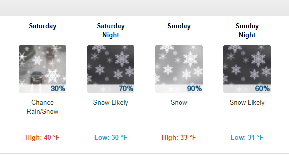
I'm just really confused right now. I don't know where the cliff is at the moment, much less jumping from it. I'm asking pedestrians passing by if they know where it is, but they just keep walking....lol. GSP thinks it's a Miller A (Awesome!), Raleigh says it's going to "evolve" into a Miller B (boo!). All major models and ensembles have a crushing winter storm for north of CLT. However models are showing very marginal 850s and surface temps, and monster WAA lurking behind the curtain!. During the day Sunday looks like it can go to almost 40 degrees. Just going to keep riding this emotional roller coaster up and down...from what I can see though, the trends have been good for many on the board today. I think?
-
Here's my forecast in Mooresville. What warm nose? lol. I don't know I'm sure I'll probably switch over too, but it's nice at this point that NWS says I may not. We'll see what tomorrow holds....
-
Wow, they poo poo'd the whole thing, didn't they? Even for the Triad. Cold rain trend for the Triad? I'm lost on that one.
-
We need Kuechera ensemble mean snow maps.
-
Lol, yep, I'll take my 30 inches and love it!...until the next Euro run! I saw the low further east off the coast and I knew it was going to be a better run than last night.
-
I'm surprised that even with a strong stj storm with confluence and some blocking we still get a Miller b. I dont know how in the world to get a miller a anymore.
-
I've seen 2 noticeable trends on the EPS. First, the 50/50 low has trended stronger and SW, which I think is good. That's why our high pressure is modeled great and our confluence is keeping the low suppressed in the gulf nicely. However it seems like once the storm hits the coast, the northern stream energy is phasing and tugging it closer to the coast on the last several runs. Therefore I still like the threat of a good first thump of snow/sleet, but once the storm is to our south, things may pull north and WAA will take over. That's right now. Hopefully that 50/50 will get keep trending stronger and the northern energy will trend slower to keep this thing south.
-
Thanks grit, hopefully that corrects south tonight. It seems to be going back and forth, bit north, bit south.
-
Yeah I noticed the model output doesn't seem to reflect the snowfall output, even the Kuchera map. I don't know why. I like the pretty maps though....even in a "bad" run I'm getting nice clown maps.
-
As long as we keep having these awesome ensemble tracks that keep creeping colder and more suppressed, I won't worry about op runs until Thursday. Other than UK and Euro. I want them in my camp continually and right now. That goes without saying right?
-
Lol, what in the world is that? feedback issues? Squiggly wiggly...
-
Wait, what? Is that a 12-15 inch mean on the EPS ensembles? Trying to work here people, how did this happen? lol. I don't think I've ever seen that kind of thing. Beautiful.
-
Agreed, the ensembles seem rock steady on rolling this thing east along the panhandle and off the coast. I hope the FV3 idea of the inland tug is out to lunch. Temps, confluence and CAD seem to be the question mark still. What on the 500 maps do we look for better/worse confluence? Thank you Grit for the excellent play by play on this storm by the way...
-
Are the means cold? I thought they were pretty marginal, from 850 means that I could see.
-
At this long lead, I wonder why the NWS doesn't lean more heavily on ensembles. They seem to base their forecast on guidance from operational models in their discussion.
-
Man if we can't get a warning criteria snow in the NC piedmont/Upstate out of that sweet look in December, I will never expect snow again in December. Geez. I don't know how I could draw it any better, other than a stronger high. We suck if we can't snow with that.
-
Boo, Dr No does it again. Can't beat a EURO/UK combo. Temps just don't want to play ball in early December. Maybe we can reset and get a similar setup in January for the win....
-
Not terrible, but not the cold run we wanted. Also the low is a bit more north than we'd like. I don't know. UK and Euro on the warmer side doesn't make me overly optimistic today. On to tomorrow.