(002).png.f2cbd7c955dc3007a02ab79925b174ec.png)
ChescoWx
-
Posts
11,182 -
Joined
-
Last visited
Content Type
Profiles
Blogs
Forums
American Weather
Media Demo
Store
Gallery
Everything posted by ChescoWx
-
(002).thumb.png.6e3d9d46bca5fe41aab7a74871dd8af8.png)
1/6 snowstorm - nuisance event or something bigger?
ChescoWx replied to LVblizzard's topic in Philadelphia Region
-
1/6 snowstorm - nuisance event or something bigger?
ChescoWx replied to LVblizzard's topic in Philadelphia Region
-
1/6 snowstorm - nuisance event or something bigger?
ChescoWx replied to LVblizzard's topic in Philadelphia Region
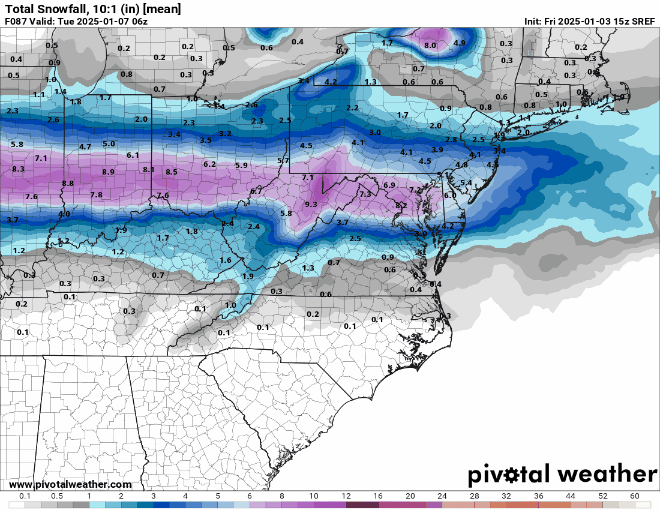
That high??? -
1/6 snowstorm - nuisance event or something bigger?
ChescoWx replied to LVblizzard's topic in Philadelphia Region
GFS also just a hair north of 6z run -
1/6 snowstorm - nuisance event or something bigger?
ChescoWx replied to LVblizzard's topic in Philadelphia Region
Canadian at 12z came north from it's 0z run -
1/6 snowstorm - nuisance event or something bigger?
ChescoWx replied to LVblizzard's topic in Philadelphia Region
Thanks Kevin! -
Another sub-freezing day on tap today before light snow arrives toward daybreak tomorrow from southwest to northeast across the area. The well-advertised snow event should bring the most relative snow to areas closest to the Maryland and Delaware borders. Depending on how much snow falls in your area we could see some blowing and drifting snow issues by Tuesday afternoon. Cold temperatures but dry for the rest of the week before another potential winter event may arrive next weekend.
-
1/6 snowstorm - nuisance event or something bigger?
ChescoWx replied to LVblizzard's topic in Philadelphia Region
Thinking 1" for Northern Chesco to as much as 3" for Southern Chesco...if I was forecasting. -
1/6 snowstorm - nuisance event or something bigger?
ChescoWx replied to LVblizzard's topic in Philadelphia Region
NAM with a relative significant reduction in snow totals coming into line with the other models. Finally some strong agreement! -
1/6 snowstorm - nuisance event or something bigger?
ChescoWx replied to LVblizzard's topic in Philadelphia Region
12z NBM -
1/6 snowstorm - nuisance event or something bigger?
ChescoWx replied to LVblizzard's topic in Philadelphia Region
12z HRRR -
1/6 snowstorm - nuisance event or something bigger?
ChescoWx replied to LVblizzard's topic in Philadelphia Region
Seems to do better with adjusting for temps to show better or less than 10:1 -
1/6 snowstorm - nuisance event or something bigger?
ChescoWx replied to LVblizzard's topic in Philadelphia Region
Suspect most would be most pleased if the 0z NAM was close to reality (not that I believe it) but very nice run! Still snowing at 8pm -
1/6 snowstorm - nuisance event or something bigger?
ChescoWx replied to LVblizzard's topic in Philadelphia Region
By 1pm on the 0z NAM -
1/6 snowstorm - nuisance event or something bigger?
ChescoWx replied to LVblizzard's topic in Philadelphia Region
0z NAM has 6 inch line up thru almost half of Chester County at 11am -
1/6 snowstorm - nuisance event or something bigger?
ChescoWx replied to LVblizzard's topic in Philadelphia Region
NAM has 3" line up to Turnpike at 8am Monday.... -
1/6 snowstorm - nuisance event or something bigger?
ChescoWx replied to LVblizzard's topic in Philadelphia Region
18z NAM with it's typical NAMmed run with an increase in snow amounts over 12z -
1/6 snowstorm - nuisance event or something bigger?
ChescoWx replied to LVblizzard's topic in Philadelphia Region
-
1/6 snowstorm - nuisance event or something bigger?
ChescoWx replied to LVblizzard's topic in Philadelphia Region
From Meteorologist Drew Anderson at Fox 29 (If I was forecasting this is what mine would look like) -
1/6 snowstorm - nuisance event or something bigger?
ChescoWx replied to LVblizzard's topic in Philadelphia Region
Steve at NYNJPA's forecast this AM -
A few snow showers are across the area this AM. Temps today will struggle to get much above 30 degrees in most spots. Sunny tomorrow before snow arrives toward Monday morning. Any potential snow should be over by Monday evening. Well below normal temperatures but dry all this coming week before our next potential snow event next weekend.
-
1/6 snowstorm - nuisance event or something bigger?
ChescoWx replied to LVblizzard's topic in Philadelphia Region
-
1/6 snowstorm - nuisance event or something bigger?
ChescoWx replied to LVblizzard's topic in Philadelphia Region