ChescoWx
-
Posts
9,684 -
Joined
-
Last visited
Content Type
Profiles
Blogs
Forums
American Weather
Media Demo
Store
Gallery
Everything posted by ChescoWx
-
Today will be the warmest day of the next week with many spots outside of the higher elevations reaching 90 degrees for the first time here in July. We turn cooler and finally less humid tomorrow and Saturday with temperatures running a couple of degrees below normal highs for late July. Shower chances increase again by Saturday night into Sunday. Early next week looks like it will continue to be a little below normal with comfortable humidity levels.

-

E PA/NJ/DE Summer 2025 Obs/Discussion
ChescoWx replied to Hurricane Agnes's topic in Philadelphia Region
Today will be the warmest day of the next week with many spots outside of the higher elevations reaching 90 degrees for the first time here in July. We turn cooler and finally less humid tomorrow and Saturday with temperatures running a couple of degrees below normal highs for late July. Shower chances increase again by Saturday night into Sunday. Early next week looks like it will continue to be a little below normal with comfortable humidity levels.
-
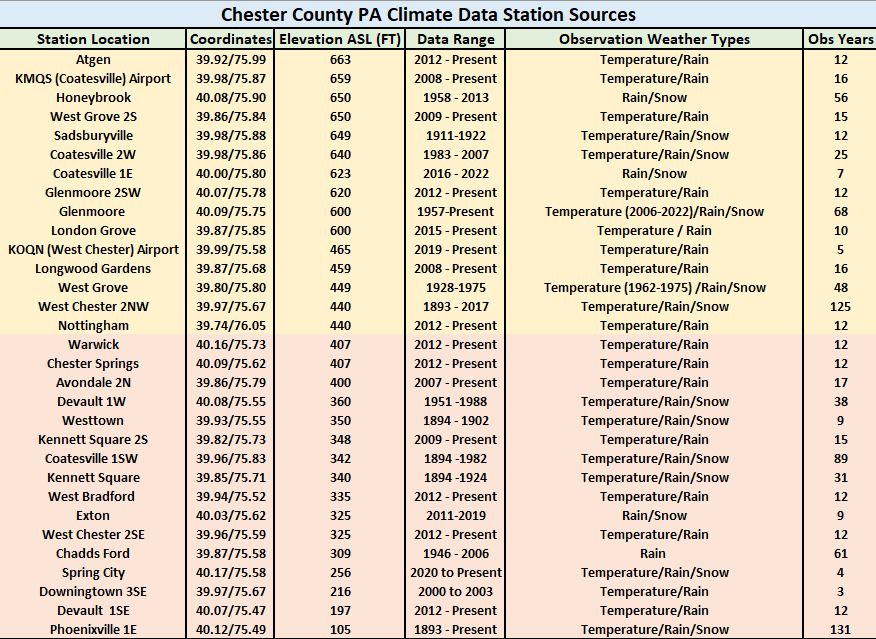
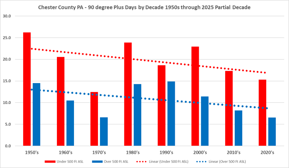
Actually at Avondale 2N almost flat very slight upward trend mainly thanks to last year....after this low 90 plus season it will change! The clear data of remaining validated stations is a downward trend in 90 plus days!
-
If we exclude it the trend of course remains...
-
LOL!! so the cooling trend must be real if the UHI PHL Airport agrees!!
-
2012 for Atglen
-
Yes - below is over the last 15 years across 15 Chester County PA stations with reporting and no movements
-
I mean across all of the other stations in the county
-
But the rest of the data still clearly shows a lessening of 90 plus days....not surprising in our current warm cycle with higher DPs and mins with lower maxes.
-
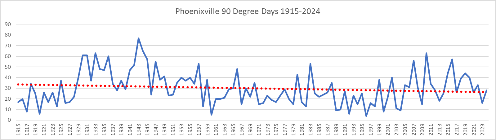
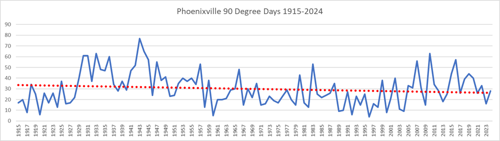
By the way Charlie that Phoenixville chart includes Ghastly ghost data from 1896 thru 1914.....wonder if that fake data impacted your charting??
-
Nope - Phoenixville 90 plus days are indeed decreasing
-
As seems to always be the case in this pattern showers are again likely later today into this evening. Today and tomorrow look like our warmest days...with some spots especially tomorrow possibly touching 90 degrees for the first time here in the month of July. The NWS has issued a heat advisory for tomorrow afternoon. We then turn a bit cooler with high temperatures maybe a couple of degrees below normal, starting Friday and through the weekend with highs in the low 80's. Highest rain chances after this evening look to be Saturday night into Sunday.

-
E PA/NJ/DE Summer 2025 Obs/Discussion
ChescoWx replied to Hurricane Agnes's topic in Philadelphia Region
As seems to always be the case in this pattern showers are again likely later today into this evening. Today and tomorrow look like our warmest days...with some spots especially tomorrow possibly touching 90 degrees for the first time here in the month of July. The NWS has issued a heat advisory for tomorrow afternoon. We then turn a bit cooler with high temperatures maybe a couple of degrees below normal, starting Friday and through the weekend with highs in the low 80's. Highest rain chances after this evening look to be Saturday night into Sunday.
-
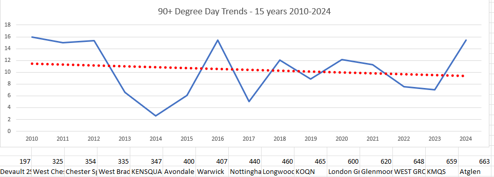
An analysis below of our declining number of 90 degree days over the past 7.5 decades here in Chester County. I have split the stations by elevation. Those over 500 ft vs those at lower elevations.
-
An analysis below of our declining number of 90 degree days over the past 7.5 decades here in Chester County. I have split the stations by elevation. Those over 500 ft vs those at lower elevations.
-
E PA/NJ/DE Summer 2025 Obs/Discussion
ChescoWx replied to Hurricane Agnes's topic in Philadelphia Region
Some rainfall amounts from yesterday Glenmoore 1.63" / East Nantmeal 1.83" / Atglen 0.20" / Chester Springs 0.75" / Devault 0.42" / Kennett Square 1.52" / Longwood Gardens 0.84" / West Bradford 0.75" / Nottingham 0.16" / Warwick Twp. 1.50" / West Chester 0.43'/ West Grove 0.09" / Avondale 2N 0.35" / KOQN Airport 0.36" / KMQS Airport 0.38". Some spots like here in East Nantmeal are up to almost 6" of rain so far this month. But that is nowhere near the record rains for the month of July across Chester and SE Berks Counties - see the top 10 rainy months below. Of course we still have time and more rain looks likely this week....so stay tuned!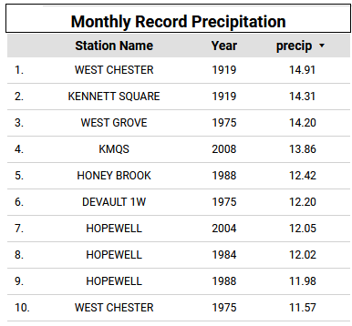
-
1.81" so far in East Nantmeal with 5.91" in July so far.....
-
E PA/NJ/DE Summer 2025 Obs/Discussion
ChescoWx replied to Hurricane Agnes's topic in Philadelphia Region
1.81" so far in East Nantmeal with 5.91" in July so far..... -
Flash flood watch for today starts at 2pm and lasts till 2am. We should see widespread rain and t-storms later today into tonight. Some spots could see 1" to as much as 3" of rain. Shower chances will continue most of the week before finally some improvement toward next weekend. Suspect we may see another flood watch for later tomorrow into Wednesday.

-
E PA/NJ/DE Summer 2025 Obs/Discussion
ChescoWx replied to Hurricane Agnes's topic in Philadelphia Region
Flash flood watch for today starts at 2pm and lasts till 2am. We should see widespread rain and t-storms later today into tonight. Some spots could see 1" to as much as 3" of rain. Shower chances will continue most of the week before finally some improvement toward next weekend. Suspect we may see another flood watch for later tomorrow into Wednesday.
-
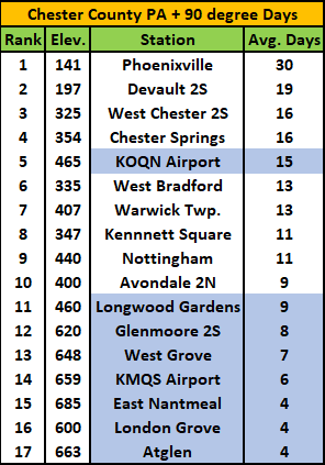
Below is an analysis of the average number of 90 plus days here in Chester County. You will notice how important elevation is to the number of such days. Elevations above 460 feet average 15.3 days over 90 degrees while locations below 460 feet (blue highlighted stations) average only 7.1 days in the summer.
-
E PA/NJ/DE Summer 2025 Obs/Discussion
ChescoWx replied to Hurricane Agnes's topic in Philadelphia Region
Today looks like a perfect beach day...but I have a family event down in Wildwood which will not involve the beach. Have an awesome day!! -
Zero evidence that any small impacts of our current warming climate change cycle has led to any disasters anywhere in the world!