(002).png.f2cbd7c955dc3007a02ab79925b174ec.png)
ChescoWx
-
Posts
11,175 -
Joined
-
Last visited
Content Type
Profiles
Blogs
Forums
American Weather
Media Demo
Store
Gallery
Everything posted by ChescoWx
-
(002).thumb.png.6e3d9d46bca5fe41aab7a74871dd8af8.png)
E PA/NJ/DE Summer 2026 Obs/Discussion
ChescoWx replied to PhiEaglesfan712's topic in Philadelphia Region
Our extreme heat watch goes into effect starting on Wednesday. The next couple of days will be close to average for the end of June. Most spots should reach the low 90's starting on Wednesday with the peak hot days being both Thursday and Friday with highs in the upper 90's in most spots to near 100 in lower elevation valley locations. Storm chances increase a little on Independence Day and will help trim temperatures a little by the end of next weekend.

-
You will no doubt see and hear a lot of alarmist news stories later this week saying the current heatwave is "unprecedented" across the Eastern US. However, as confirmed in a new peer reviewed study in the Journal of Theoretical and Applied Climatology, Christy (2026) “The results indicate that extremes in heat-related metrics for daily TMax in the summer have not increased and in fact often show modest declines since 1899, due mostly to the early heat events during 1925-1954” Those period of years are also the hottest period here in Chester County PA. So over the last century, there has been no evidence of an increase in heatwaves in the United Stares no matter what you will see on your TV later this week. It is simply called summer!! Stay cool!!
-
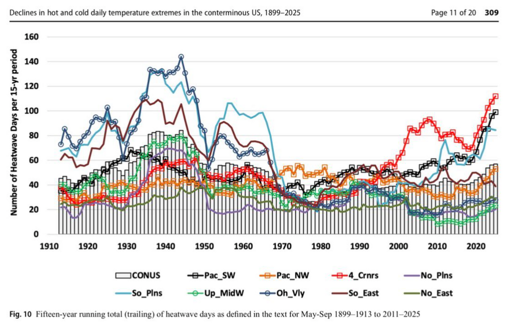
A really interesting statistic for the entire USA which exactly mirrors the data I share here from the philly burbs of Chester County. This below analysis measures not the typical metric of 90+ days but unusual hot periods of at least 4 days on average across the entire country where the average temperature reaches a level based on historical records that would be expected to only occur once every 10 years. Look how much hotter the entire nation was back in 1930's and 1940's compared to today! No matter how much we hear about how hot it is today we have still not reached that peak heating from the 1930 through 1942 period which matches the hottest period here in Chester County PA.

-
Central PA Summer 2026 Discussion/Obs Thread
ChescoWx replied to Voyager's topic in Upstate New York/Pennsylvania
A really interesting statistic for the entire USA which exactly mirrors the data I share here from the philly burbs of Chester County. This below analysis measures not the typical metric of 90+ days but unusual hot periods of at least 4 days on average across the entire country where the average temperature reaches a level based on historical records that would be expected to only occur once every 10 years. Look how much hotter the entire nation was back in 1930's and 1940's compared to today! No matter how much we hear about how hot it is today we have still not reached that peak heating from the 1930 through 1942 period which matches the hottest period here in Chester County PA.
-
E PA/NJ/DE Summer 2026 Obs/Discussion
ChescoWx replied to PhiEaglesfan712's topic in Philadelphia Region
A really interesting statistic for the entire USA which exactly mirrors the data I share here from Chester County. This below analysis measures not the typical metric of 90+ days but unusual hot periods of at least 4 days on average across the entire country where the average temperature reaches a level based on historical records that would be expected to only occur once every 10 years. Look how much hotter the entire nation was back in 1930's and 1940's compared to today! No matter how much we hear about how hot it is today we have still not reached that peak heating from the 1930 through 1942 period which matches the hottest period here in Chester County PA.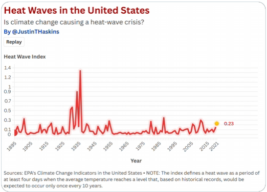
-
Central PA Summer 2026 Discussion/Obs Thread
ChescoWx replied to Voyager's topic in Upstate New York/Pennsylvania
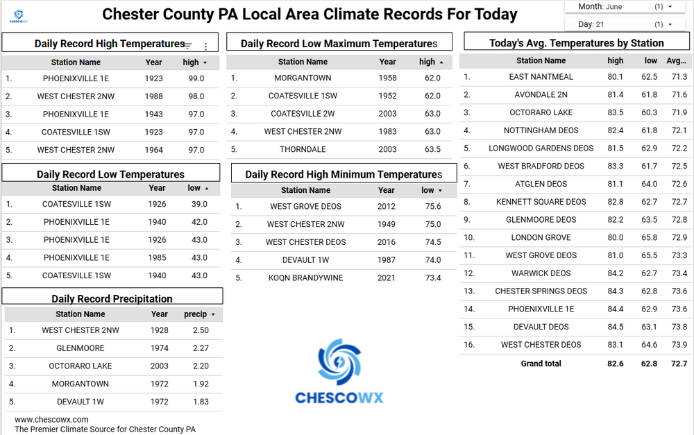
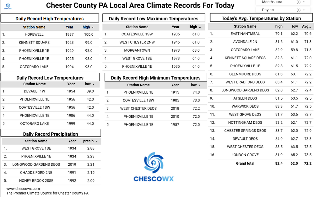
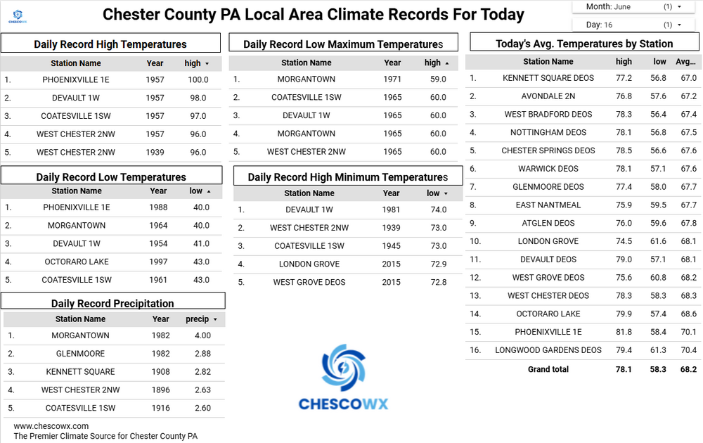
Plenty of lows in the 50's across the area this morning with the lowest being the 50.0 at the Warwick DEOS. Today will be our 9th day in the last 10 with slightly below normal temperatures. Great weather through Thursday before rain chances increase again by Thursday night into Saturday morning. We should slowly warm up next week to above normal temperatures as we close out the month of June.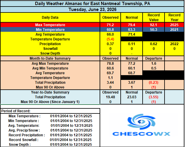

-
E PA/NJ/DE Summer 2026 Obs/Discussion
ChescoWx replied to PhiEaglesfan712's topic in Philadelphia Region
Plenty of lows in the 50's across the area this morning with the lowest being the 50.0 at the Warwick DEOS. Today will be our 9th day in the last 10 with slightly below normal temperatures. Great weather through Thursday before rain chances increase again by Thursday night into Saturday morning. We should slowly warm up next week to above normal temperatures as we close out the month of June.
-
E PA/NJ/DE Summer 2026 Obs/Discussion
ChescoWx replied to PhiEaglesfan712's topic in Philadelphia Region
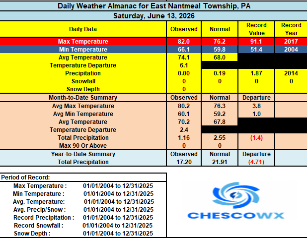
1.34" in East Nantmeal since yesterday -
E PA/NJ/DE Summer 2026 Obs/Discussion
ChescoWx replied to PhiEaglesfan712's topic in Philadelphia Region
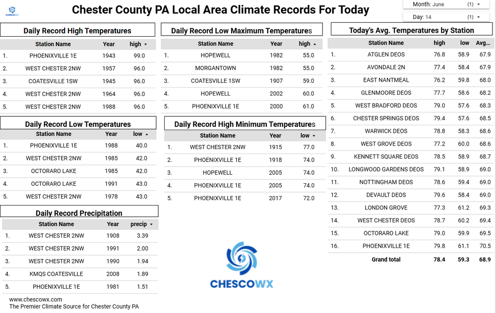
Some area rain amounts so far from this afternoon. KOQN 1.30"/ East Nantmeal 0.95" / Devault 0.75" / Warwick 0.46" / Chester Springs 0.11" / KMQS 0.03" / Glenmoore 0.08" / Nottingham 0.20" Kennett Square 0.30" / West Chester DEOS 0.71" -
Central PA Summer 2026 Discussion/Obs Thread
ChescoWx replied to Voyager's topic in Upstate New York/Pennsylvania
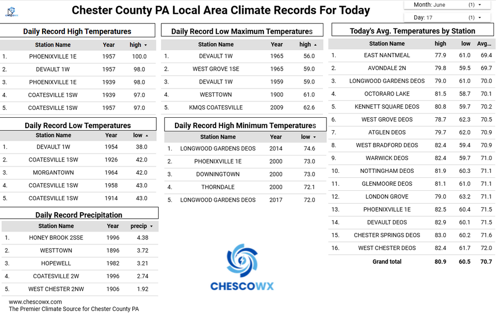
A Flood watch is in effect starting at 2pm today. Rain will arrive from west to east later this afternoon. We could see some thunderstorms. There is still some uncertainty to where the heaviest rain will fall. For now it appears from 0.5" across NW Chesco to over an inch possible toward SE Chester County. Highs today and tomorrow will be several degrees below normal with the clouds and rain. We dry out later Tuesday through much of Thursday before more rain arrives Thursday night into Friday.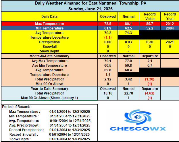
-
E PA/NJ/DE Summer 2026 Obs/Discussion
ChescoWx replied to PhiEaglesfan712's topic in Philadelphia Region
A Flood watch is in effect starting at 2pm today. Rain will arrive from west to east later this afternoon. We could see some thunderstorms. There is still some uncertainty to where the heaviest rain will fall. For now it appears from 0.5" across NW Chesco to over an inch possible toward SE Chester County. Highs today and tomorrow will be several degrees below normal with the clouds and rain. We dry out later Tuesday through much of Thursday before more rain arrives Thursday night into Friday.
-
Central PA Summer 2026 Discussion/Obs Thread
ChescoWx replied to Voyager's topic in Upstate New York/Pennsylvania
Happy Father's Day to all the dad's out there! Plus happy first day of summer which began this morning at 4:24am. Another great weather day is on tap across the area. Temperatures are not far from typical levels for very early summer. Rain chances to ramp up by later tomorrow before we clear out for mid-week. Shower chances return again by Thursday afternoon.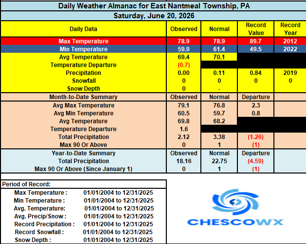
-
E PA/NJ/DE Summer 2026 Obs/Discussion
ChescoWx replied to PhiEaglesfan712's topic in Philadelphia Region
Happy Father's Day to all the dad's out there! Plus happy first day of summer which began this morning at 4:24am. Another great weather day is on tap across the area. Temperatures are not far from typical levels for very early summer. Rain chances to ramp up by later tomorrow before we clear out for mid-week. Shower chances return again by Thursday afternoon.
-
Central PA Summer 2026 Discussion/Obs Thread
ChescoWx replied to Voyager's topic in Upstate New York/Pennsylvania
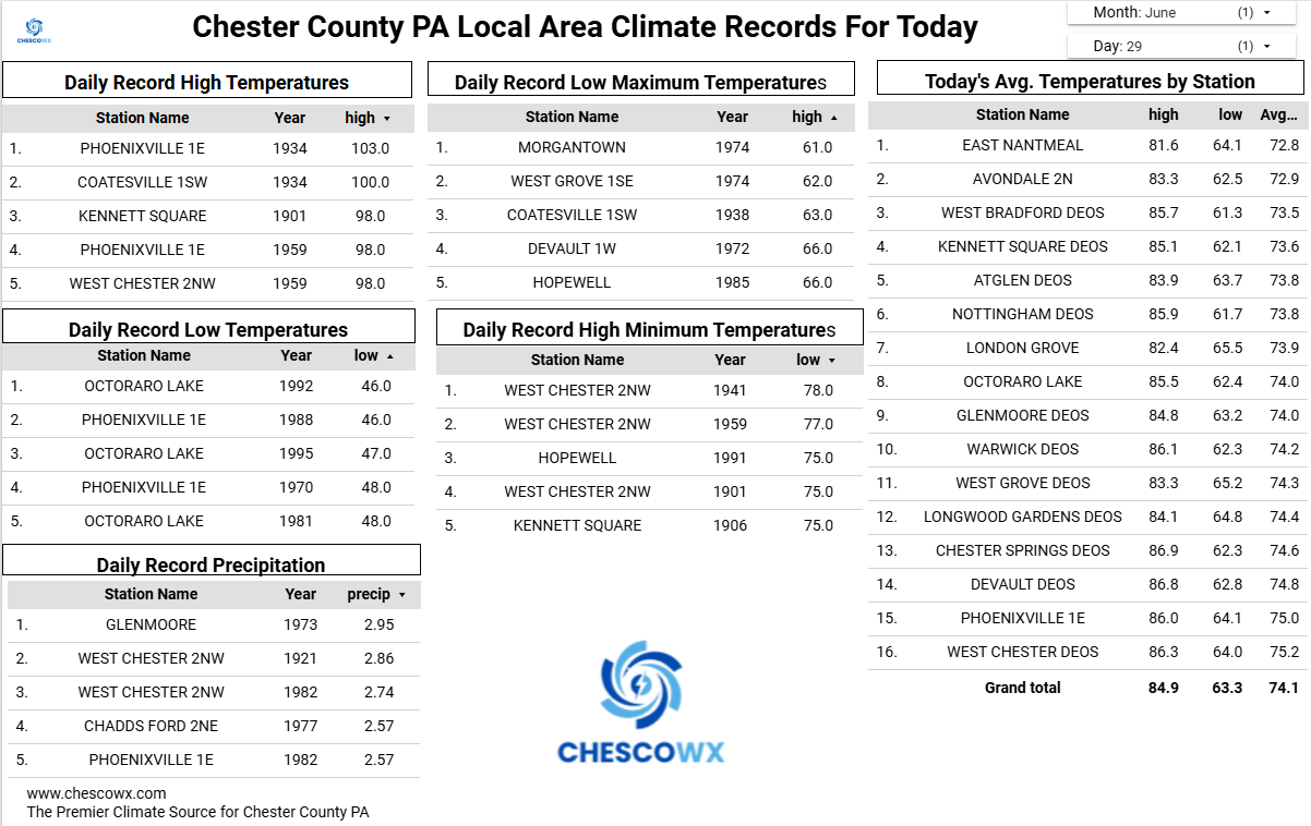
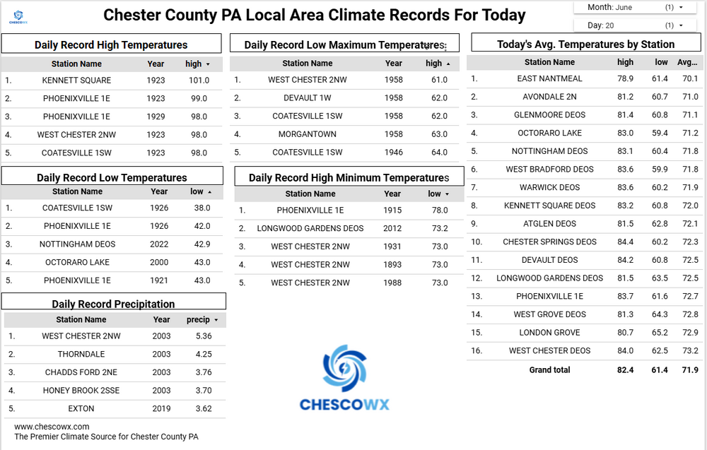
Plenty of 50's and even 40's this morning with our typical cold valley location Warwick Twp reaching 49.8 degrees. To contrast that just a couple miles south of there but a few hundred feet higher in East Nantmeal Twp. we only reached 59.9 (over 10 degrees warmer). Great weather continues today and tomorrow with highs close to normal around 80 degrees. It still looks like Monday will bring some beneficial rains to the area with at least an inch of rain for many spots still likely. We turn drier and cooler for the rest of the work week with highs a couple of degrees below normal.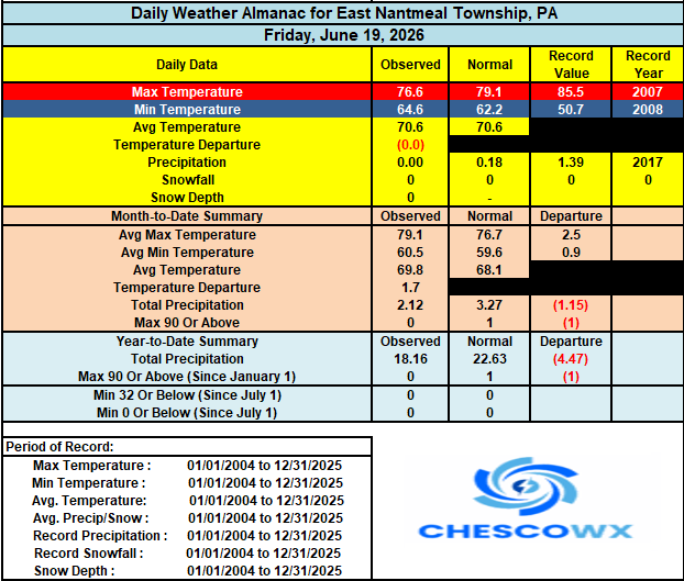
-
E PA/NJ/DE Summer 2026 Obs/Discussion
ChescoWx replied to PhiEaglesfan712's topic in Philadelphia Region
Plenty of 50's and even 40's this morning with our typical cold valley location Warwick Twp reaching 49.8 degrees. To contrast that just a couple miles south of there but a few hundred feet higher in East Nantmeal Twp. we only reached 59.9 (over 10 degrees warmer). Great weather continues today and tomorrow with highs close to normal around 80 degrees. It still looks like Monday will bring some beneficial rains to the area with at least an inch of rain for many spots still likely. We turn drier and cooler for the rest of the work week with highs a couple of degrees below normal.
-
Central PA Summer 2026 Discussion/Obs Thread
ChescoWx replied to Voyager's topic in Upstate New York/Pennsylvania
Below normal temperatures for most of the next week with beneficial rains arriving for much of the area by late Sunday into Monday. Sun should return this afternoon with lower humidity. The weekend looks great with highs in the upper 70's to near 80 degrees and lows in the 50's. The rain Monday could be significant with most models painting as much as 1" to 1.5" of needed rain.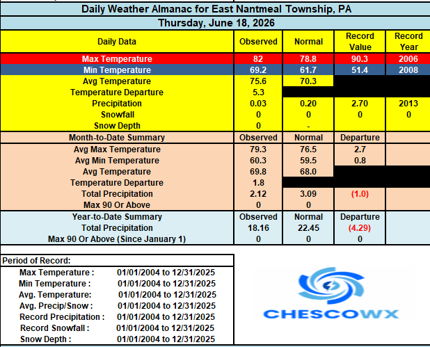
-
E PA/NJ/DE Summer 2026 Obs/Discussion
ChescoWx replied to PhiEaglesfan712's topic in Philadelphia Region
Below normal temperatures for most of the next week with beneficial rains arriving for much of the area by late Sunday into Monday. Sun should return this afternoon with lower humidity. The weekend looks great with highs in the upper 70's to near 80 degrees and lows in the 50's. The rain Monday could be significant with most models painting as much as 1" to 1.5" of needed rain.
-
Central PA Summer 2026 Discussion/Obs Thread
ChescoWx replied to Voyager's topic in Upstate New York/Pennsylvania
Today will be our warmest day for at least the next week. Highs today will be at least 5 degrees above normal in the mid to upper 80's. Some showers are around this morning into early this afternoon. There is a chance of a heavier storm with the cold frontal passage this afternoon, but unfortunately no widespread rain appears likely. We turn back to normal to below temperatures through the middle of next week with highs in the upper 70's to low 80's and lows in the mid to upper 50's. Shower chances increase by Sunday night into Monday morning.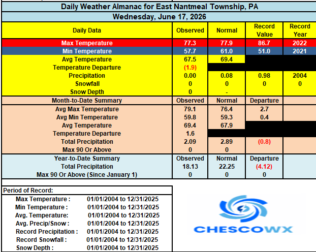

-
E PA/NJ/DE Summer 2026 Obs/Discussion
ChescoWx replied to PhiEaglesfan712's topic in Philadelphia Region
Today will be our warmest day for at least the next week. Highs today will be at least 5 degrees above normal in the mid to upper 80's. Some showers are around this morning into early this afternoon. There is a chance of a heavier storm with the cold frontal passage this afternoon, but unfortunately no widespread rain appears likely. We turn back to normal to below temperatures through the middle of next week with highs in the upper 70's to low 80's and lows in the mid to upper 50's. Shower chances increase by Sunday night into Monday morning.
-
Central PA Summer 2026 Discussion/Obs Thread
ChescoWx replied to Voyager's topic in Upstate New York/Pennsylvania
With the exception of tomorrow temperatures over the next week should be near normal for late June with highs in the upper 70's to lower 80's. Thursday will be our warmest day of the week along with a chance of some showers. Lows over the weekend will return to the comfortable 50's for most spots across the area. Shower chances increase by Sunday night and through Monday.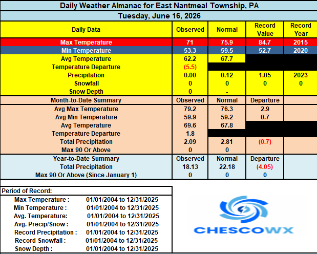
-
E PA/NJ/DE Summer 2026 Obs/Discussion
ChescoWx replied to PhiEaglesfan712's topic in Philadelphia Region
With the exception of tomorrow temperatures over the next week should be near normal for late June with highs in the upper 70's to lower 80's. Thursday will be our warmest day of the week along with a chance of some showers. Lows over the weekend will return to the comfortable 50's for most spots across the area. Shower chances increase by Sunday night and through Monday.
-
Central PA Summer 2026 Discussion/Obs Thread
ChescoWx replied to Voyager's topic in Upstate New York/Pennsylvania
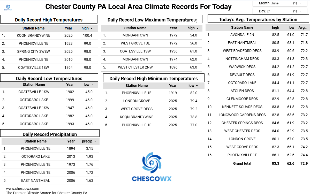
Plenty of chilly lows in the 40's across Chesco valley locales this AM. The lowest I could find was the 45.8 low at our typical chilly spot up in Warwick Twp. Another near perfect day on tap today with highs from the mid 70's along the ridges to the upper 70's in the valleys. We warm up with shower chances both Wednesday night and Thursday with highs well into the 80's. We turn cooler again for the weekend with highs remaining in the 70's in the higher spots with lots of sunshine.
-
E PA/NJ/DE Summer 2026 Obs/Discussion
ChescoWx replied to PhiEaglesfan712's topic in Philadelphia Region
Plenty of chilly lows in the 40's across Chesco valley locales this AM. The lowest I could find was the 45.8 low at our typical chilly spot up in Warwick Twp. Another near perfect day on tap today with highs from the mid 70's along the ridges to the upper 70's in the valleys. We warm up with shower chances both Wednesday night and Thursday with highs well into the 80's. We turn cooler again for the weekend with highs remaining in the 70's in the higher spots with lots of sunshine.
-
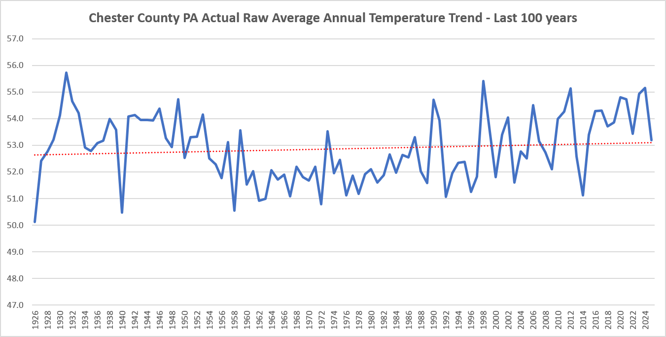
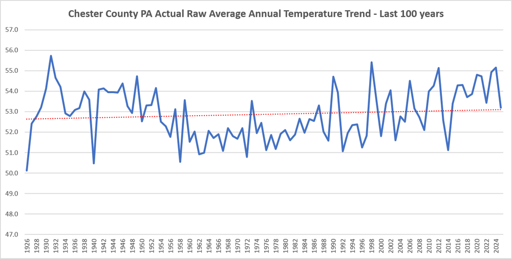
Sure after chilling adjustments made to the past for 90 consecutive years across Chester County......below is the realistic and actual temperature graph covering the last 100 years....no climate crisis here without those consistent post hoc alterations to the actual real data! Still trying to get as warm as the old days back in the 1930's and 1940's!
-
Central PA Summer 2026 Discussion/Obs Thread
ChescoWx replied to Voyager's topic in Upstate New York/Pennsylvania
Much more humid today before a strong cold front crosses later this evening. The best chances for thunderstorms and rain will be between 8pm and 11pm across the area. Tomorrow and Tuesday will feature much cooler weather with highs only in the low to mid 70's with night well down into the 50's with 40's possible in our usually colder valley locations. We briefly warm again toward Thursday before we turn cooler for next weekend.