(002).png.f2cbd7c955dc3007a02ab79925b174ec.png)
ChescoWx
-
Posts
11,175 -
Joined
-
Last visited
Content Type
Profiles
Blogs
Forums
American Weather
Media Demo
Store
Gallery
Everything posted by ChescoWx
-
(002).thumb.png.6e3d9d46bca5fe41aab7a74871dd8af8.png)
Central PA Summer 2026 Discussion/Obs Thread
ChescoWx replied to Voyager's topic in Upstate New York/Pennsylvania
Folks that live here understand the difference....and the data backs it up. thanks! -
Central PA Summer 2026 Discussion/Obs Thread
ChescoWx replied to Voyager's topic in Upstate New York/Pennsylvania
Of course see below. You do realize that the facts and actual stats clearly show with a significant p-value that the fact remain that my EN station and the Chester County PA USCRN are statistically exactly the same with over 7,000 days of daily historical data since 2007. Facts have nothing to do with a degreed meteorologist view or "thoughts" on the actual data. You may not like it but it is factual and they don't care about your feelings.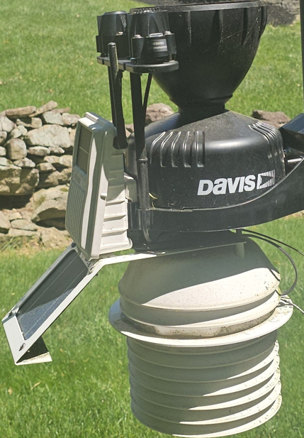
-
Central PA Summer 2026 Discussion/Obs Thread
ChescoWx replied to Voyager's topic in Upstate New York/Pennsylvania
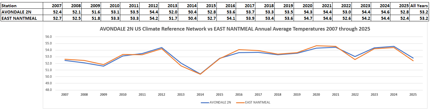
LOL!! Both you and @Stebohave of course been clearly wrong for years as the below data certainly shows. Below is an analysis of the US Climate Resource Network Site here in Chester County vs. East Nantmeal for the last 19 years of average annual temperature data. Well looky at this! Over the last 19 years we are not only close we are exactly the same!!! 53.2 degrees vs 53.2 degrees!! If you are unfamiliar with US CRN it is a systematic network of more than 130 highly accurate climate-monitoring stations across the United States, managed by the National Oceanic and Atmospheric Administration (NOAA). Now how many degrees again do you think EN is off??
-
Central PA Summer 2026 Discussion/Obs Thread
ChescoWx replied to Voyager's topic in Upstate New York/Pennsylvania
Of course not...even today only a 1.8 degree difference from the highest elevation station mine in East Nantmeal at 94.8 and West Grove in far Southern Chesco at 96.6 -
Central PA Summer 2026 Discussion/Obs Thread
ChescoWx replied to Voyager's topic in Upstate New York/Pennsylvania
As of 5pm no Chester County professional stations have hit 100 degrees the highest was at the Longwood Gardens DEOS with 99.3 degrees. All stations were between 95 and 99 degrees -
Central PA Summer 2026 Discussion/Obs Thread
ChescoWx replied to Voyager's topic in Upstate New York/Pennsylvania
94.8 degrees for the high so far today in EN. This is now the 5th warmest reading here in East Nantmeal in the last 23 years back to 2004! Top 10 warmest are below...of note that same day 7/22/11 is the only day KMQS Coatesville Airport has ever recorded a 100 degree reading.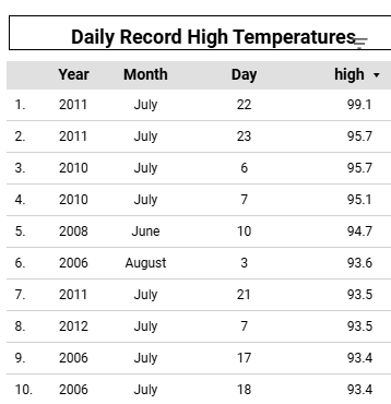
-
E PA/NJ/DE Summer 2026 Obs/Discussion
ChescoWx replied to PhiEaglesfan712's topic in Philadelphia Region
KMQS has only reached 100 degrees one time since records began on July 22, 2011 when they hit 100.4 - that was also my hottest day when we hit 99.1 degrees -
E PA/NJ/DE Summer 2026 Obs/Discussion
ChescoWx replied to PhiEaglesfan712's topic in Philadelphia Region
I went to a business persons special during that magical summer of 1993 against the Cardinals....I was dripping the entire game! I have no idea how folks are sitting through this game at CBP this afternoon!! -
Central PA Summer 2026 Discussion/Obs Thread
ChescoWx replied to Voyager's topic in Upstate New York/Pennsylvania
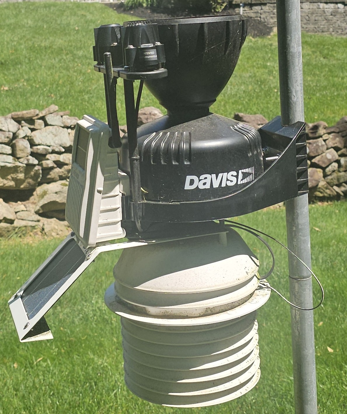
Some folks on my FB page were asking about thermometer siting after seeing some reports of 107 in my area while I am 92.6 I posted the below along with some guidance from the NWS. Some have questioned if they should allow their thermometer to receive direct sunlight. Per the NWS "Radiation Shield: "Never place a thermometer in direct sunlight" unless you have a louvered radiation shield and/or a fan aspiration unit (see my station photo below) My station does receive direct sunlight but I have both the shield and fan aspiration to ensure my reported temps are not sun inflated. Per the NWS "Use a slotted "beehive" or louvered radiation shield that blocks direct and reflected sunlight while allowing air to flow freely.Surrounding Terrain: The thermometer should sit over natural vegetation, such as grass, rather than over patios, artificial turf, or bare dirt.Clearance from Obstructions: Place the sensor away from structures. The distance between your thermometer and any nearby trees, buildings, or fences should be at least four times the height of the obstruction (e.g., if a tree is 20 feet tall, the sensor should be 80 feet away). Artificial Heat Sources: Keep the sensor at least 100 feet away from paved driveways, parking lots, and large concrete surfaces. Additionally, ensure it is far from artificial heat exhausts, such as furnace vents, chimneys, and air conditioning."
-
E PA/NJ/DE Summer 2026 Obs/Discussion
ChescoWx replied to PhiEaglesfan712's topic in Philadelphia Region
Some folks on my FB page were asking about thermometer siting after seeing some reports of 107 in my area while I am 92.6 I posted the below along with some guidance from the NWS. Some have questioned if they should allow their thermometer to receive direct sunlight. Per the NWS "Radiation Shield: "Never place a thermometer in direct sunlight" unless you have a louvered radiation shield and/or a fan aspiration unit (see my station photo below) My station does receive direct sunlight but I have both the shield and fan aspiration to ensure my reported temps are not sun inflated. Per the NWS "Use a slotted "beehive" or louvered radiation shield that blocks direct and reflected sunlight while allowing air to flow freely.Surrounding Terrain: The thermometer should sit over natural vegetation, such as grass, rather than over patios, artificial turf, or bare dirt.Clearance from Obstructions: Place the sensor away from structures. The distance between your thermometer and any nearby trees, buildings, or fences should be at least four times the height of the obstruction (e.g., if a tree is 20 feet tall, the sensor should be 80 feet away). Artificial Heat Sources: Keep the sensor at least 100 feet away from paved driveways, parking lots, and large concrete surfaces. Additionally, ensure it is far from artificial heat exhausts, such as furnace vents, chimneys, and air conditioning."
-
Central PA Summer 2026 Discussion/Obs Thread
ChescoWx replied to Voyager's topic in Upstate New York/Pennsylvania
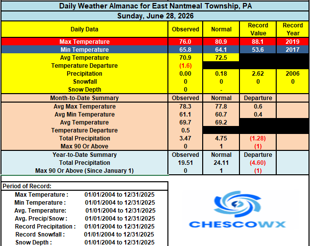
Today will be our hottest day with the possibility that many lower spots touch 100 degrees and could approach the record for the day of 103 degrees set way back in 1901 at Coatesville 1SW at 103 degrees. We have not set a record high in the month of July since back on July 24, 2016 when a record of 100 degrees was set at Phoenixville 1E. The heat continues through the weekend but with shower chances steadily increasing by later July 4th through the day on Monday. Temperatures will fall back to near normal by Tuesday and back to below normal temperatures by Wednesday.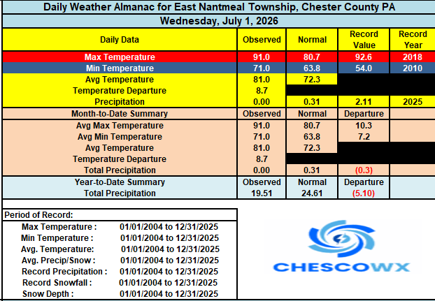

-
E PA/NJ/DE Summer 2026 Obs/Discussion
ChescoWx replied to PhiEaglesfan712's topic in Philadelphia Region
Today will be our hottest day with the possibility that many lower spots touch 100 degrees and could approach the record for the day of 103 degrees set way back in 1901 at Coatesville 1SW at 103 degrees. We have not set a record high in the month of July since back on July 24, 2016 when a record of 100 degrees was set at Phoenixville 1E. The heat continues through the weekend but with shower chances steadily increasing by later July 4th through the day on Monday. Temperatures will fall back to near normal by Tuesday and back to below normal temperatures by Wednesday.
-
Central PA Summer 2026 Discussion/Obs Thread
ChescoWx replied to Voyager's topic in Upstate New York/Pennsylvania
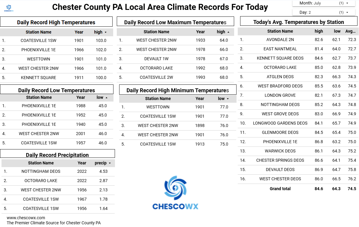
Here in East Nantmeal I recorded a high of 91.0 degrees this is only the 66th time since 2004 we have seen a 90+ day at this location. This is the first such day here since last June 25, 2025. Other area highs Atglen DEOS 92.2 / KMQS 92.1 / Glenmoore DEOS 93.6 / Nottingham DEOS 91.2 / Warwick DEOS 94.8 / Devault DEOS 94.8 / Kennett Square DEOS 94.3 / Longwood Gardens DEOS 94.6 / West Bradford DEOS 93.1 / West Chester DEOS 96.8 / West Grove DEOS 92.6 -
E PA/NJ/DE Summer 2026 Obs/Discussion
ChescoWx replied to PhiEaglesfan712's topic in Philadelphia Region
Here in East Nantmeal I recorded a high of 91.0 degrees this is only the 66th time since 2004 we have seen a 90+ day at this location. This is the first such day here since last June 25, 2025. Other area highs Atglen DEOS 92.2 / KMQS 92.1 / Glenmoore DEOS 93.6 / Nottingham DEOS 91.2 / Warwick DEOS 94.8 / Devault DEOS 94.8 / Kennett Square DEOS 94.3 / Longwood Gardens DEOS 94.6 / West Bradford DEOS 93.1 / West Chester DEOS 96.8 / West Grove DEOS 92.6 -
Central PA Summer 2026 Discussion/Obs Thread
ChescoWx replied to Voyager's topic in Upstate New York/Pennsylvania
Got it! thanks! -
Central PA Summer 2026 Discussion/Obs Thread
ChescoWx replied to Voyager's topic in Upstate New York/Pennsylvania
We finished June with temperatures for the month only slightly above normal. Our extremely hot stretch of weather begins today and will continue through the weekend. The hottest days look to be both Thursday and Friday where we will be in the upper 90's on the ridges and near or above 100 degrees in the valley locales. Shower chances increase by July 4th night and continue into Sunday and Monday. This will start to trim the extremely high temperatures and by next Tuesday we will be back to near normal with highs in the mid 80's.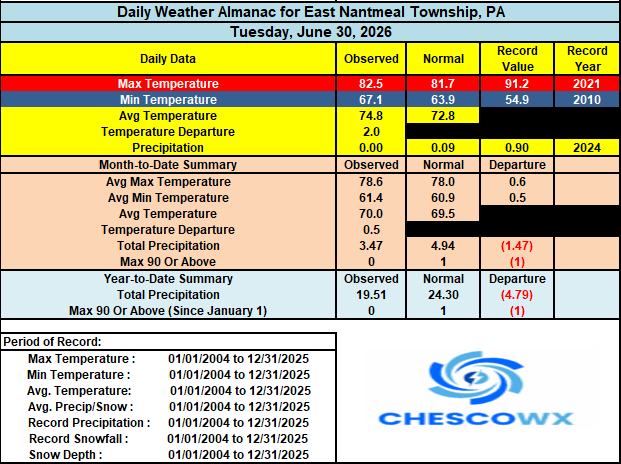

-
E PA/NJ/DE Summer 2026 Obs/Discussion
ChescoWx replied to PhiEaglesfan712's topic in Philadelphia Region
We finished June with temperatures for the month only slightly above normal. Our extremely hot stretch of weather begins today and will continue through the weekend. The hottest days look to be both Thursday and Friday where we will be in the upper 90's on the ridges and near or above 100 degrees in the valley locales. Shower chances increase by July 4th night and continue into Sunday and Monday. This will start to trim the extremely high temperatures and by next Tuesday we will be back to near normal with highs in the mid 80's.
-
E PA/NJ/DE Summer 2026 Obs/Discussion
ChescoWx replied to PhiEaglesfan712's topic in Philadelphia Region
Today should be our last sub 90 degree high until Monday. Mid to upper 80's today rising into the low to mid 90's tomorrow and then upper 90's in higher spots to near 100 in our valley locations both Thursday and Friday. Shower chances increase later July 4th with the days trending slightly cooler with highs by Monday in the upper 80's.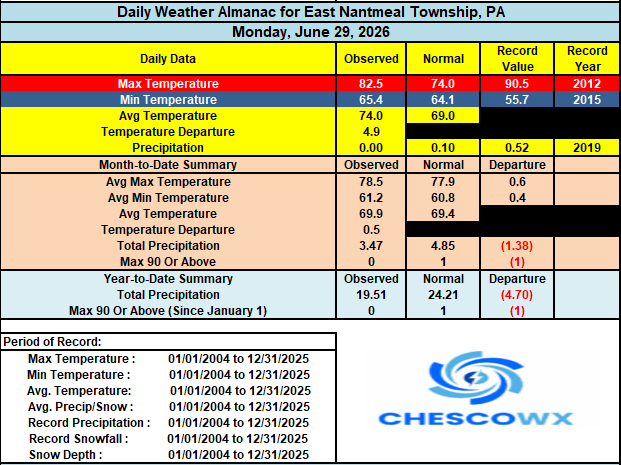
-
Central PA Summer 2026 Discussion/Obs Thread
ChescoWx replied to Voyager's topic in Upstate New York/Pennsylvania
Of course station location placement and relative elevation -
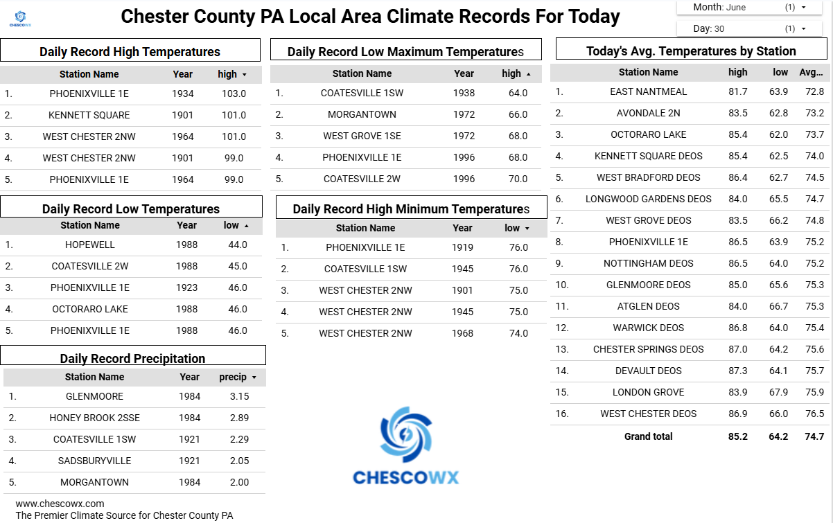
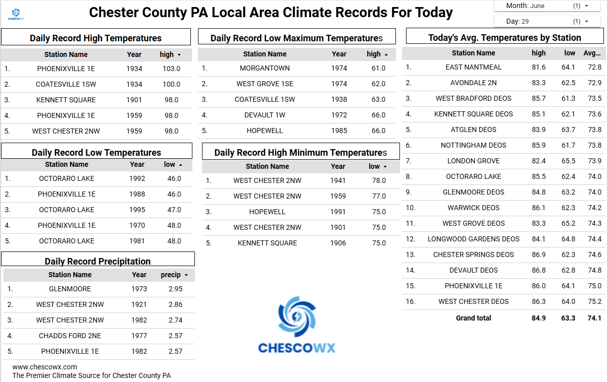
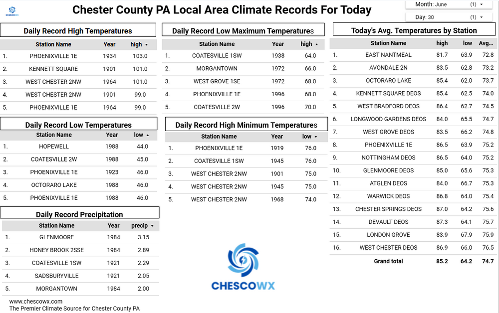
With a chance that some locations could see a 100-degree day later this week I went back and analyzed 30 temperature stations across the area to see just how rare such a day has become. A 100-degree day is a rare occurrence across most spots across the County. With the potential being even more rare across the relatively higher ridge stations above 595 ft. In fact the last time any ridge location station saw a 100-degree reading was 15 years ago back on July 22, 2011. Of the 18 current stations across the area that report temperatures 9 of these have never recorded such a day. Our lowest elevation stations at Phoenixville and nearby Spring City both recorded a 100+ day last June. To illustrate how different the temperature elevation impact can be on June 26, 2025 while Spring City (256 ft ASL) was hitting the century mark....not too far away at Glenmoore DEOS (620 FT ASL) but 400 feet higher the high was 10 degrees cooler at "only" 90.6

-
Central PA Summer 2026 Discussion/Obs Thread
ChescoWx replied to Voyager's topic in Upstate New York/Pennsylvania
With a chance that some locations could see a 100-degree day later this week I went back and analyzed 30 temperature stations across the area to see just how rare such a day has become. A 100-degree day is a rare occurrence across most spots across the County. With the potential being even more rare across the relatively higher ridge stations above 595 ft. In fact the last time any ridge location station saw a 100-degree reading was 15 years ago back on July 22, 2011. Of the 18 current stations across the area that report temperatures 9 of these have never recorded such a day. Our lowest elevation stations at Phoenixville and nearby Spring City both recorded a 100+ day last June. To illustrate how different the temperature elevation impact can be on June 26, 2025 while Spring City (256 ft ASL) was hitting the century mark....not too far away at Glenmoore DEOS (620 FT ASL) but 400 feet higher the high was 10 degrees cooler at "only" 90.6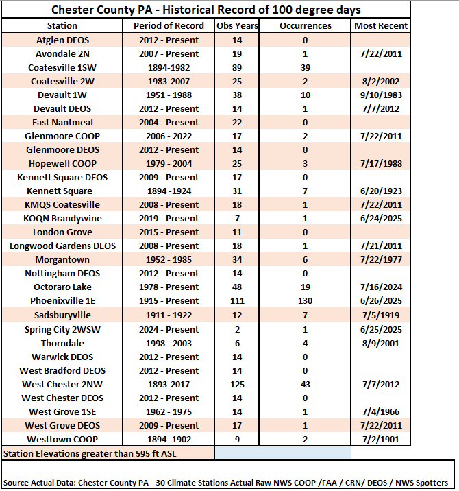
-
E PA/NJ/DE Summer 2026 Obs/Discussion
ChescoWx replied to PhiEaglesfan712's topic in Philadelphia Region
With a chance that some locations could see a 100-degree day later this week I went back and analyzed 30 temperature stations across the area to see just how rare such a day has become. A 100-degree day is a rare occurrence across most spots across the County. With the potential being even more rare across the relatively higher ridge stations above 595 ft. In fact the last time any ridge location station saw a 100-degree reading was 15 years ago back on July 22, 2011. Of the 18 current stations across the area that report temperatures 9 of these have never recorded such a day. Our lowest elevation stations at Phoenixville and nearby Spring City both recorded a 100+ day last June. To illustrate how different the temperature elevation impact can be on June 26, 2025 while Spring City (256 ft ASL) was hitting the century mark....not too far away at Glenmoore DEOS (620 FT ASL) but 400 feet higher the high was 10 degrees cooler at "only" 90.6
-
Central PA Summer 2026 Discussion/Obs Thread
ChescoWx replied to Voyager's topic in Upstate New York/Pennsylvania
Our extreme heat watch goes into effect starting on Wednesday. The next couple of days will be close to average for the end of June. Most spots should reach the low 90's starting on Wednesday with the peak hot days being both Thursday and Friday with highs in the upper 90's in most spots to near 100 in lower elevation valley locations. Storm chances increase a little on Independence Day and will help trim temperatures a little by the end of next weekend.