(002).png.f2cbd7c955dc3007a02ab79925b174ec.png)
ChescoWx
-
Posts
11,175 -
Joined
-
Last visited
Content Type
Profiles
Blogs
Forums
American Weather
Media Demo
Store
Gallery
Everything posted by ChescoWx
-
(002).thumb.png.6e3d9d46bca5fe41aab7a74871dd8af8.png)
Central PA Spring 2026 Discussion/Obs Thread
ChescoWx replied to Voyager's topic in Upstate New York/Pennsylvania
Some outstanding weather on the way for much of the next week. We will stay a few degrees below normal until maybe warming up close to average temperatures for June by next weekend. In fact here in East Nantmeal May will finish as the 6th below normal month over the last 8 months dating back to last October. Rain chances look slim to none over the next week.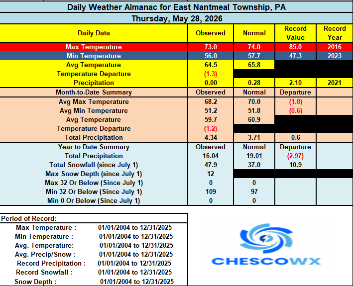
-
E PA/NJ/DE Spring 2026 Obs/Discussion
ChescoWx replied to PhiEaglesfan712's topic in Philadelphia Region
Some outstanding weather on the way for much of the next week. We will stay a few degrees below normal until maybe warming up close to average temperatures for June by next weekend. In fact here in East Nantmeal May will finish as the 6th below normal month over the last 8 months dating back to last October. Rain chances look slim to none over the next week.
-
Central PA Spring 2026 Discussion/Obs Thread
ChescoWx replied to Voyager's topic in Upstate New York/Pennsylvania
A great stretch of weather with temperatures running at least a few degrees below normal for the end of May and the start of June. With highs in the upper 60's to lower 70's and nights in the upper 40's to lower 50's. No rain chances through the weekend.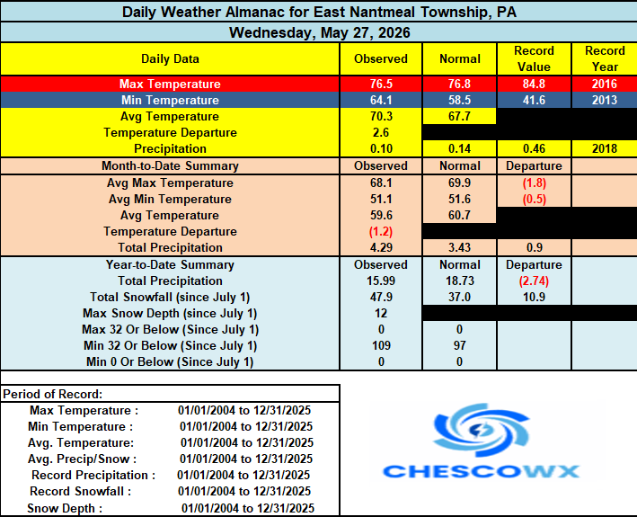
-
E PA/NJ/DE Spring 2026 Obs/Discussion
ChescoWx replied to PhiEaglesfan712's topic in Philadelphia Region
A great stretch of weather with temperatures running at least a few degrees below normal for the end of May and the start of June. With highs in the upper 60's to lower 70's and nights in the upper 40's to lower 50's. No rain chances through the weekend.
-
Central PA Spring 2026 Discussion/Obs Thread
ChescoWx replied to Voyager's topic in Upstate New York/Pennsylvania
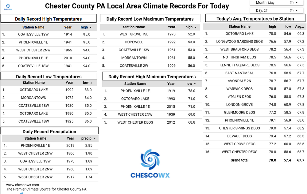
Some more needed rain is crossing the area this morning. We are now up to over 85% of our normal rainfall for the year to date here in East Nantmeal with some spots now approaching average precipitation levels for the year. Today will be our last in a stretch of mainly cloudy and wet days. A beautiful end to the work week and upcoming weekend is on the way. Plenty of sun on the way with temperatures running a few degrees below normal as we close out May and move into June.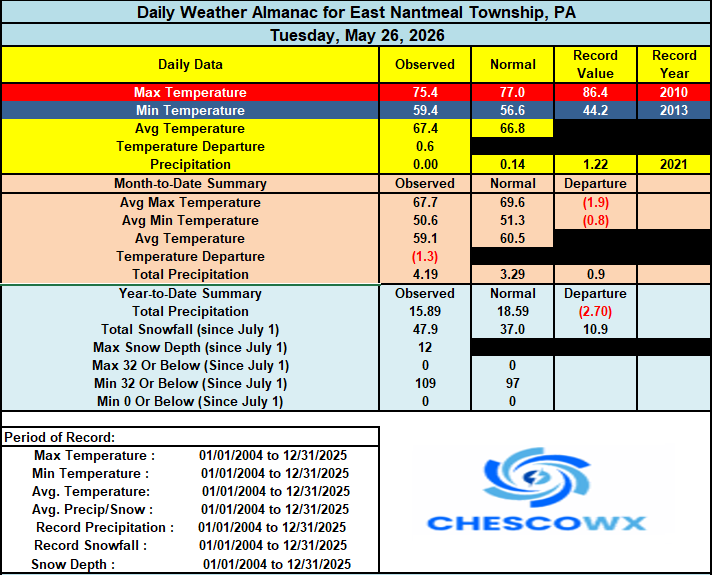
-
E PA/NJ/DE Spring 2026 Obs/Discussion
ChescoWx replied to PhiEaglesfan712's topic in Philadelphia Region
Some more needed rain is crossing the area this morning. We are now up to over 85% of our normal rainfall for the year to date here in East Nantmeal with some spots now approaching average precipitation levels for the year. Today will be our last in a stretch of mainly cloudy and wet days. A beautiful end to the work week and upcoming weekend is on the way. Plenty of sun on the way with temperatures running a few degrees below normal as we close out May and move into June.
-
Central PA Spring 2026 Discussion/Obs Thread
ChescoWx replied to Voyager's topic in Upstate New York/Pennsylvania
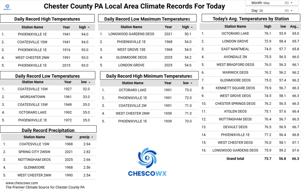
Partly sunny today with a chance of some showers tomorrow morning. Today and tomorrow will be our warmest days of the week with temperatures a couple of degrees above normal for late May with highs in the upper 70's. A great stretch of weather begins on Thursday and through the weekend with sunny skies and with temperatures cooling to several degrees below normal by Saturday with highs near 70 degrees.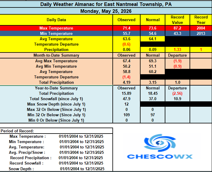
-
E PA/NJ/DE Spring 2026 Obs/Discussion
ChescoWx replied to PhiEaglesfan712's topic in Philadelphia Region
Partly sunny today with a chance of some showers tomorrow morning. Today and tomorrow will be our warmest days of the week with temperatures a couple of degrees above normal for late May with highs in the upper 70's. A great stretch of weather begins on Thursday and through the weekend with sunny skies and with temperatures cooling to several degrees below normal by Saturday with highs near 70 degrees.
-
Always fun to revisit our favorite climate alarmist - Mr. Al Gore to see how his "predictions" from The Inconvenient Truth have done with now 20 years of real data to assess his accuracy. Ice-Free Arctic Summers: Gore claimed there was a 75% chance the north polar ice cap would be completely ice-free in summer within five to seven years (by 2013-2016). The Arctic sea ice minimums have fluctuated but persist. Disappearing Snows of Kilimanjaro: He predicted that by 2016, Africa’s Mount Kilimanjaro would have no more snow. Measurable snow and glaciers remain on the mountain. Melting Glacier National Park: The film claimed that by 2021, Glacier National Park would lose all of its glaciers. The park's glaciers have shrunk, but they are still present, prompting changes to park signage. Escalating Hurricane Frequency: The documentary argued that global warming would cause a dramatic increase in the frequency and severity of hurricanes. Global data shows no trend of increasing frequency, and global accumulated cyclone energy has remained highly variable without a net upward trajectory.
-
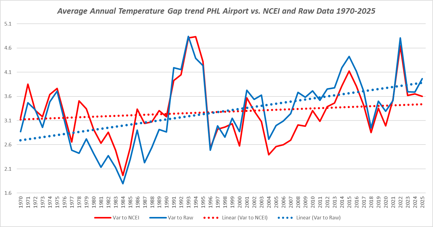
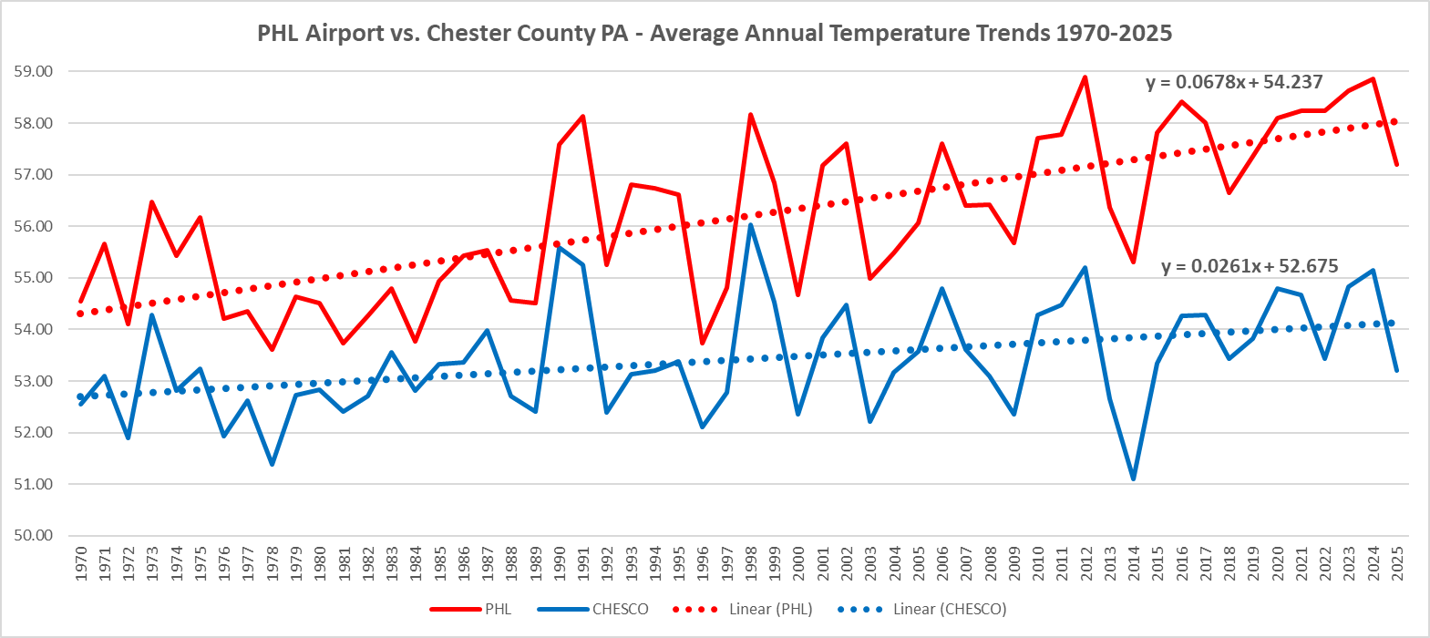
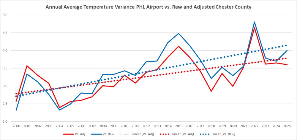
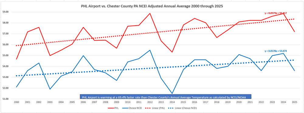
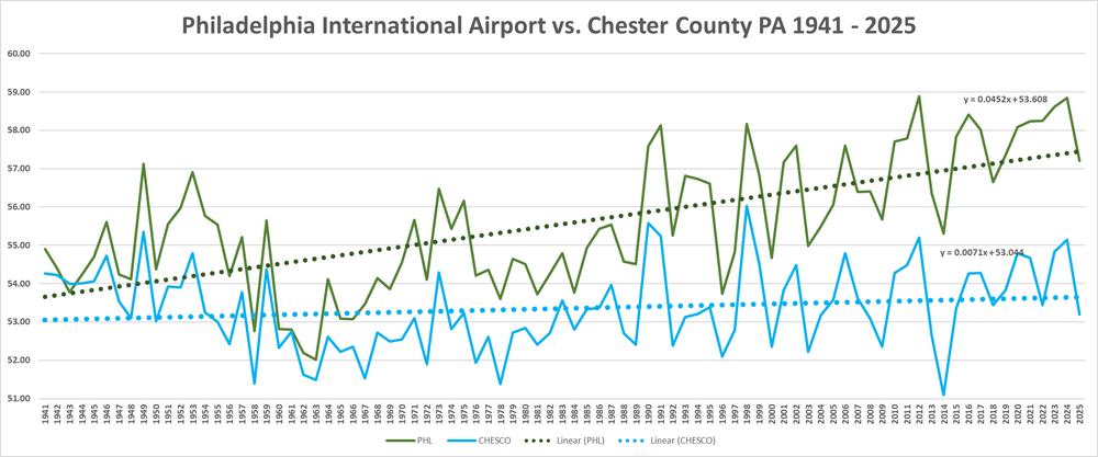
But again the facts remain - either way we look at the data both raw and altered still shows a widening gap since 1970 - no reason to think that gap will not continue to widen.

-
Central PA Spring 2026 Discussion/Obs Thread
ChescoWx replied to Voyager's topic in Upstate New York/Pennsylvania
Happy Memorial Day and thank you to those who serve our country. Still some showers around today before we finally see a return of the sun tomorrow. Temperatures both tomorrow and Wednesday will be several degrees above normal with highs not far from 80 degrees. We then see a return of cooler than normal temperatures but with mostly sunny days right through next weekend.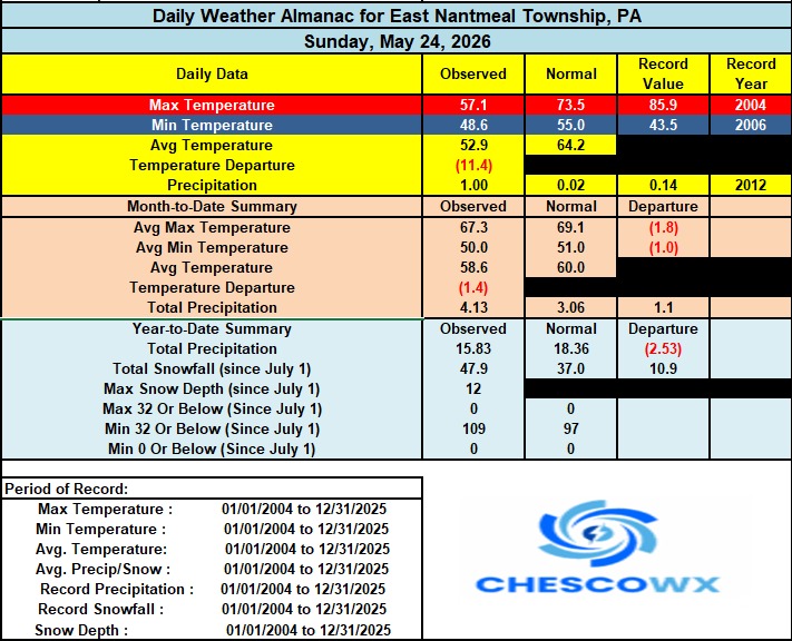

-
E PA/NJ/DE Spring 2026 Obs/Discussion
ChescoWx replied to PhiEaglesfan712's topic in Philadelphia Region
Happy Memorial Day and thank you to those who serve our country. Still some showers around today before we finally see a return of the sun tomorrow. Temperatures both tomorrow and Wednesday will be several degrees above normal with highs not far from 80 degrees. We then see a return of cooler than normal temperatures but with mostly sunny days right through next weekend.
-
No matter how you slice it using either the raw or altered adjusted data. The gap is clearly widening between PHL and Chester County
-
Central PA Spring 2026 Discussion/Obs Thread
ChescoWx replied to Voyager's topic in Upstate New York/Pennsylvania
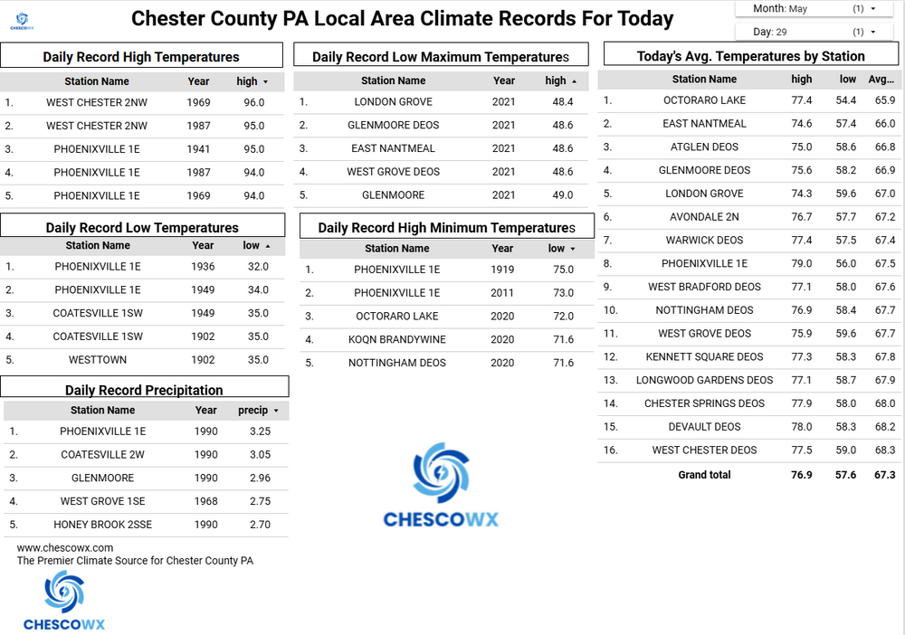
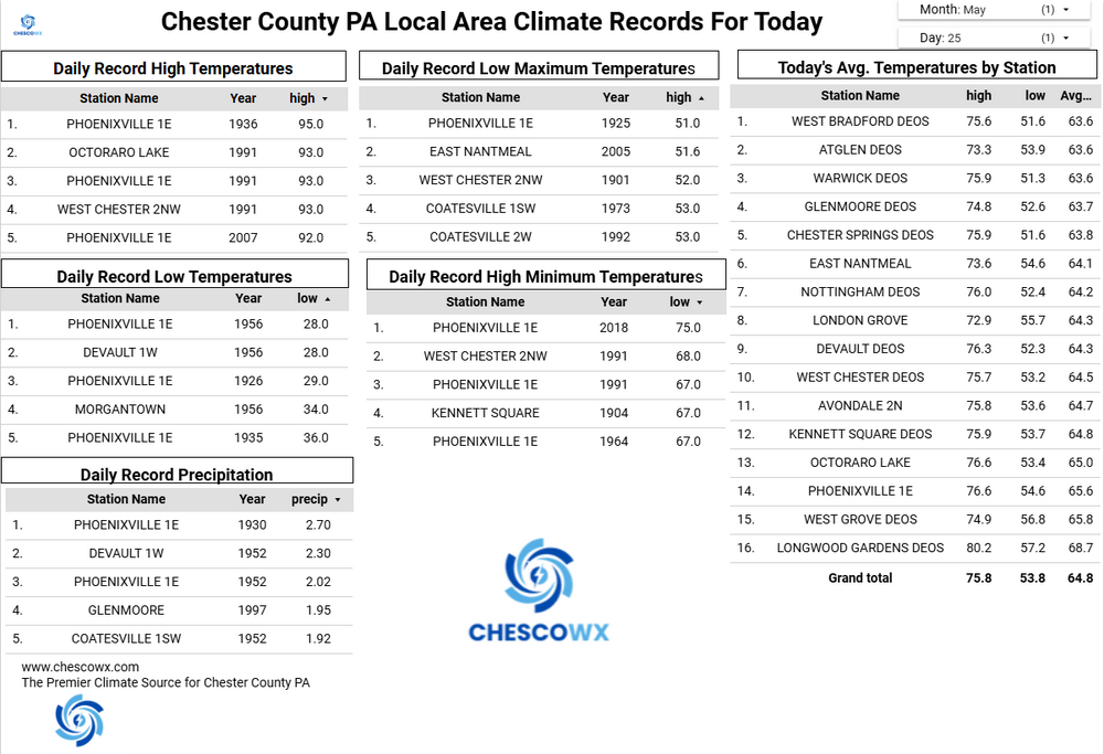
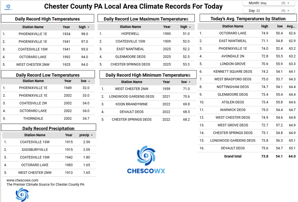
Since Tuesday a general 2.5" to 5.0" of very welcome rainfall has taken place across Chester County. West Grove 5.14" / West Bradford 4.39" / Kennett Square 4.32" / Longwood Gardens 4.22" / West Chester 3.97" / Nottingham 3.24" / Atglen 2.91" / Glenmoore 2.87" / Chester Springs 2.79" / East Nantmeal 2.62" and Warwick Twp. 2.48" -
E PA/NJ/DE Spring 2026 Obs/Discussion
ChescoWx replied to PhiEaglesfan712's topic in Philadelphia Region
Since Tuesday a general 2.5" to 5.0" of very welcome rainfall has taken place across Chester County. West Grove 5.14" / West Bradford 4.39" / Kennett Square 4.32" / Longwood Gardens 4.22" / West Chester 3.97" / Nottingham 3.24" / Atglen 2.91" / Glenmoore 2.87" / Chester Springs 2.79" / East Nantmeal 2.62" and Warwick Twp. 2.48" -
Central PA Spring 2026 Discussion/Obs Thread
ChescoWx replied to Voyager's topic in Upstate New York/Pennsylvania
Temperatures across the area have dropped into the 40's after a midnight high in the low 50's. Today will be breezy and raw with rain increasing as we move through the afternoon and especially tonight. Most of the steadiest rain should exit Chester County to the east by later tomorrow morning. Most areas should see around an inch of rain by tomorrow afternoon. Some showers will continue on Monday begore we finally dry out on Tuesday. We briefly warm up to above normal temperatures by Wednesday before we trend back to below normal temperatures by the end of the week and into next weekend.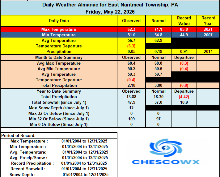
-
E PA/NJ/DE Spring 2026 Obs/Discussion
ChescoWx replied to PhiEaglesfan712's topic in Philadelphia Region
Temperatures across the area have dropped into the 40's after a midnight high in the low 50's. Today will be breezy and raw with rain increasing as we move through the afternoon and especially tonight. Most of the steadiest rain should exit Chester County to the east by later tomorrow morning. Most areas should see around an inch of rain by tomorrow afternoon. Some showers will continue on Monday begore we finally dry out on Tuesday. We briefly warm up to above normal temperatures by Wednesday before we trend back to below normal temperatures by the end of the week and into next weekend.
-
So let's go ahead and use the adjusted NCEI average annual temperatures for Chester County PA from NCEI this century. These are the adjusted altered figures Charlie....what does this tell us? Even after adjustments by NOAA PHL is indeed warming almost 70% faster than Chester County PA - the PHL UHI is a problem even NOAA shows it....
-
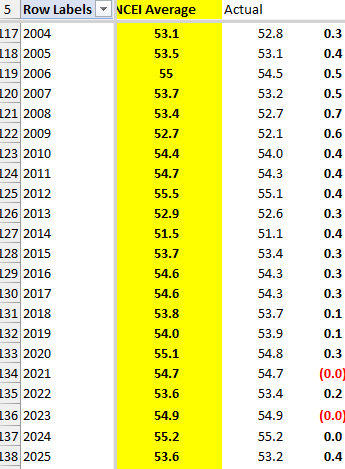
Bad assumption only using the warmest station which is Phoenixville 1E - to better determine the true Chesco average you should add in the nice mix we have today of high and low elevations to capture the true average Chester County average temperature. Heck the averages I derive from these stations is in reality supports almost exactly the calculated average temperatures posted by NCEI on their site for their recent Chester County PA average temperatures. If NCEI develops an average temperature for the county that is statistically the same as what I calculate from the raw stations. See below since 2004. NCEI must think the mix of stations I use is strong correct?
-
Central PA Spring 2026 Discussion/Obs Thread
ChescoWx replied to Voyager's topic in Upstate New York/Pennsylvania
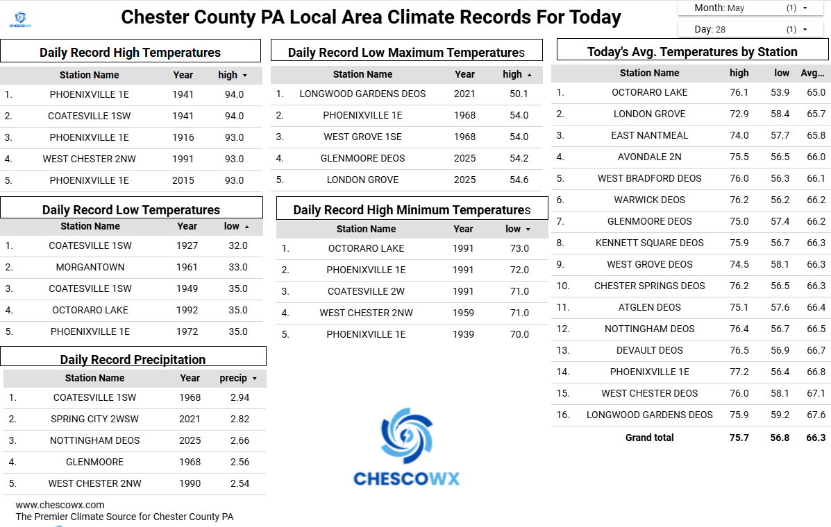
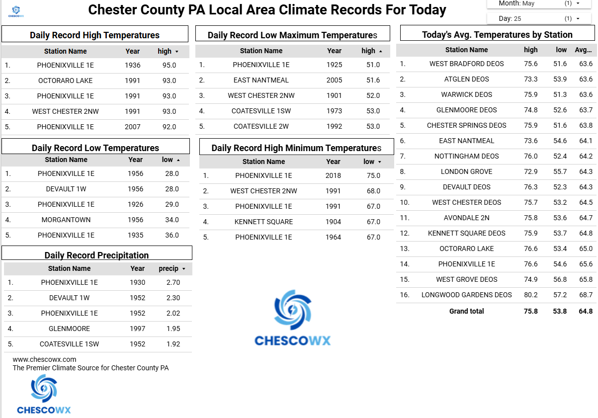
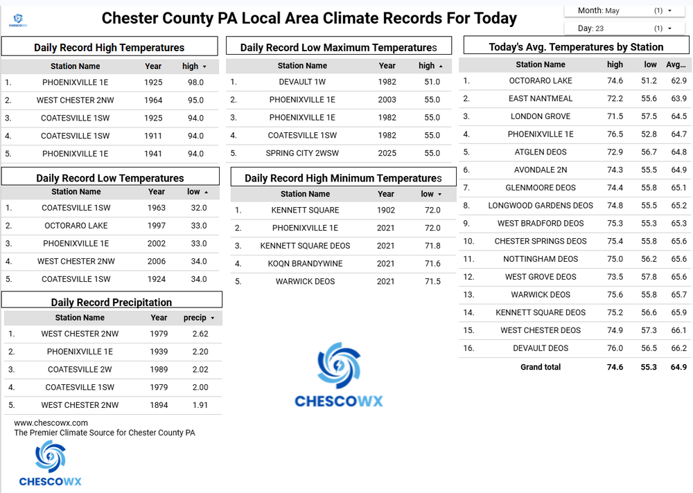
Happy Memorial Day Weekend! Unfortunately weather wise it will be wet and almost record cold especially tomorrow afternoon. Most models now keep temperatures below 50 degrees tomorrow afternoon - this would break the Chester County record for low maximum temperatures for the date set back in 1982. There is a chance it could be the coldest late season high temperature on record. With gusty winds it will feel a lot more like early March than Memorial Day Weekend. Rain-wise models show between an inch to as much as 3.5" of much needed rain!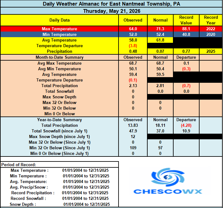
-
E PA/NJ/DE Spring 2026 Obs/Discussion
ChescoWx replied to PhiEaglesfan712's topic in Philadelphia Region
Happy Memorial Day Weekend! Unfortunately weather wise it will be wet and almost record cold especially tomorrow afternoon. Most models now keep temperatures below 50 degrees tomorrow afternoon - this would break the Chester County record for low maximum temperatures for the date set back in 1982. There is a chance it could be the coldest late season high temperature on record. With gusty winds it will feel a lot more like early March than Memorial Day Weekend. Rain-wise models show between an inch to as much as 3.5" of much needed rain!

-
Your amateur altered facts and fake math do not change the facts. To just prove it to you yet again - let's simply take the next period of time after all those changes that you think made such an impact. Let's target the modern era from 1970 through 2025. Again clear as it can be that PHL is clearly and statistically warming faster than Chester County both the trend line and the slope prove this as fact. The gap due to PHL UHI continues to widen - just wait to see by 2036 how much further apart these get!

-
Fortunately Charlie we have the facts and math to prove clearly how much faster PHL is warming than Chester County PA from 1941 through 2025. Since the growth rate not just to the eye but based on the slope certainly shows that PHL has a much steeper warming growth line than Chester County. Charlie as you can plainly see it is not even close. PHL is warming much faster than Chesco! The facts show this gap has never been wider....well not until we finish this year!
-
Central PA Spring 2026 Discussion/Obs Thread
ChescoWx replied to Voyager's topic in Upstate New York/Pennsylvania
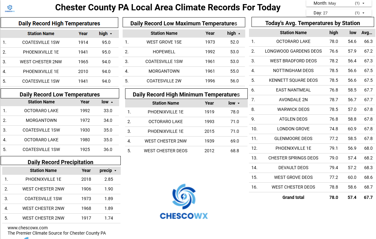
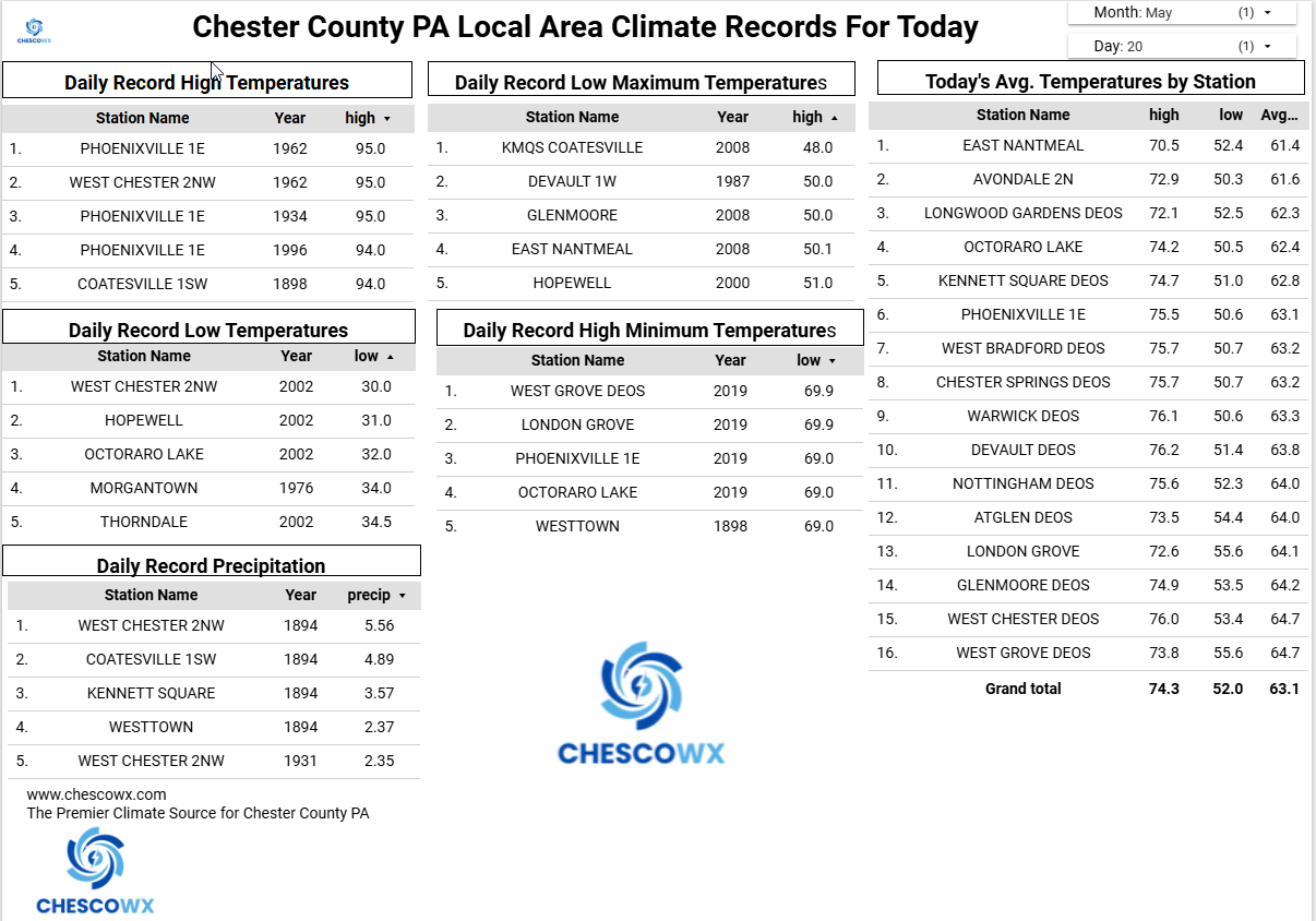
Who is ready for some weather whiplash? After one more unseasonably warm day today we flip to unseasonably chilly starting tomorrow and lasting through at least Sunday. Tomorrow's afternoon temperatures are likely to be more than 30 degrees chillier than today with widespread 50's. We turn even chillier by Saturday with some models hinting at record low maximum temperatures with highs struggling to escape the cold 40's during the afternoon. Some much-needed rain looks to arrive later today and continue off and on through tomorrow. More steady rain arrives Friday night and continues through Saturday. This combination of rain and cold will make Saturday feel more like a raw early March day than Memorial Day Weekend.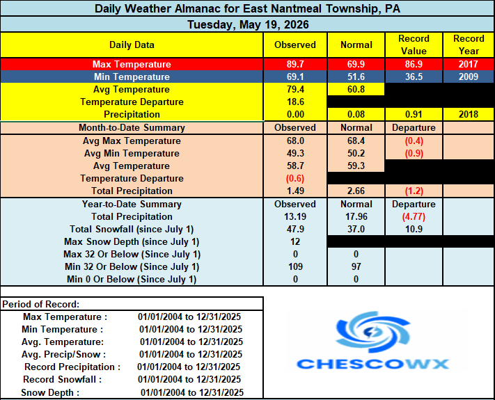

-
E PA/NJ/DE Spring 2026 Obs/Discussion
ChescoWx replied to PhiEaglesfan712's topic in Philadelphia Region
Who is ready for some weather whiplash? After one more unseasonably warm day today we flip to unseasonably chilly starting tomorrow and lasting through at least Sunday. Tomorrow's afternoon temperatures are likely to be more than 30 degrees chillier than today with widespread 50's. We turn even chillier by Saturday with some models hinting at record low maximum temperatures with highs struggling to escape the cold 40's during the afternoon. Some much-needed rain looks to arrive later today and continue off and on through tomorrow. More steady rain arrives Friday night and continues through Saturday. This combination of rain and cold will make Saturday feel more like a raw early March day than Memorial Day Weekend.