(002).png.f2cbd7c955dc3007a02ab79925b174ec.png)
ChescoWx
-
Posts
11,175 -
Joined
-
Last visited
Content Type
Profiles
Blogs
Forums
American Weather
Media Demo
Store
Gallery
Everything posted by ChescoWx
-
(002).thumb.png.6e3d9d46bca5fe41aab7a74871dd8af8.png)
E PA/NJ/DE Spring 2026 Obs/Discussion
ChescoWx replied to PhiEaglesfan712's topic in Philadelphia Region
Unseasonably chilly weather this weekend with high temperatures more than 10 degrees below normal for the end of April. We have picked up 0.04" of rain so far today here in East Nantmeal and it looks like as much as another inch could fall across the area by noon tomorrow. Temperatures this afternoon will likely fall into the 40's by evening and reach the upper 30's by morning. We warm back into the low 60's but still several degrees below normal for the rest of the work week with more rain chances by Tuesday night through Wednesday.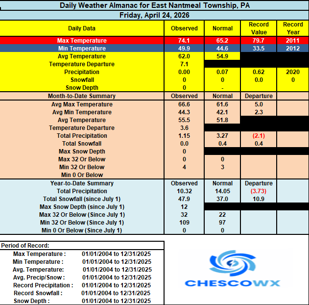
-
Central PA Spring 2026 Discussion/Obs Thread
ChescoWx replied to Voyager's topic in Upstate New York/Pennsylvania
Unseasonably chilly weekend on the way with temperatures at least 15 degrees below normal levels for late April. We start the cooling trend today with a backdoor cold front moving in from the northeast today highs should be at least 5 degrees cooler than yesterday. Beneficial rain arrives tomorrow morning and we should see rain a good bit of the time Saturday into Sunday morning with temperatures on Saturday remaining in the chilly 40's for high temperatures. We could see at least an inch of rain in many spots which is great news for our local farmers and green thumbs! We moderate next week but still a few degrees cooler than average with more showers possible by later Tuesday.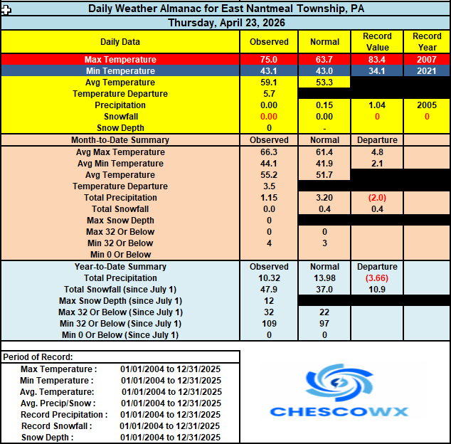

-
E PA/NJ/DE Spring 2026 Obs/Discussion
ChescoWx replied to PhiEaglesfan712's topic in Philadelphia Region
Unseasonably chilly weekend on the way with temperatures at least 15 degrees below normal levels for late April. We start the cooling trend today with a backdoor cold front moving in from the northeast today highs should be at least 5 degrees cooler than yesterday. Beneficial rain arrives tomorrow morning and we should see rain a good bit of the time Saturday into Sunday morning with temperatures on Saturday remaining in the chilly 40's for high temperatures. We could see at least an inch of rain in many spots which is great news for our local farmers and green thumbs! We moderate next week but still a few degrees cooler than average with more showers possible by later Tuesday.
-
Central PA Spring 2026 Discussion/Obs Thread
ChescoWx replied to Voyager's topic in Upstate New York/Pennsylvania
Today will likely be our mildest day for quite a while. We start a cooling trend tomorrow and it looks like our pattern over at least the next several weeks will feature generally below normal temperatures and above normal precipitation. Of note since March 1st we are at about 80% of our normal precipitation. We could pick up a 1/2 to 3/4 of an inch of rain from Friday night through Saturday. Saturday will be a chilly and raw day with winds off the still chilly ocean keeping temperatures not far from the current ocean water temp of around 50 degrees. Temperatures next week look to remain a little cooler than normal with rain chances increasing again by Monday night into Tuesday.
-
E PA/NJ/DE Spring 2026 Obs/Discussion
ChescoWx replied to PhiEaglesfan712's topic in Philadelphia Region
Today will likely be our mildest day for quite a while. We start a cooling trend tomorrow and it looks like our pattern over at least the next several weeks will feature generally below normal temperatures and above normal precipitation. Of note since March 1st we are at about 80% of our normal precipitation. We could pick up a 1/2 to 3/4 of an inch of rain from Friday night through Saturday. Saturday will be a chilly and raw day with winds off the still chilly ocean keeping temperatures not far from the current ocean water temp of around 50 degrees. Temperatures next week look to remain a little cooler than normal with rain chances increasing again by Monday night into Tuesday.
-
To state it better - The above chart Charlie highlights shows that NCEI has met their objective of taking out actual raw station data to alter the data to hide the cyclical pattern in the raw data. Of course, if you leave in all the station changes you won't match the revised/altered NCEI or any other "scientific" analysis. The above thread and data produced by chescowx consistently uses certified NWS actual data and ensures it is not influenced by bad analysis or exhibits any of the clear confirmation bias that underscores the altered data often used to support climate alarmism.
-
Central PA Spring 2026 Discussion/Obs Thread
ChescoWx replied to Voyager's topic in Upstate New York/Pennsylvania
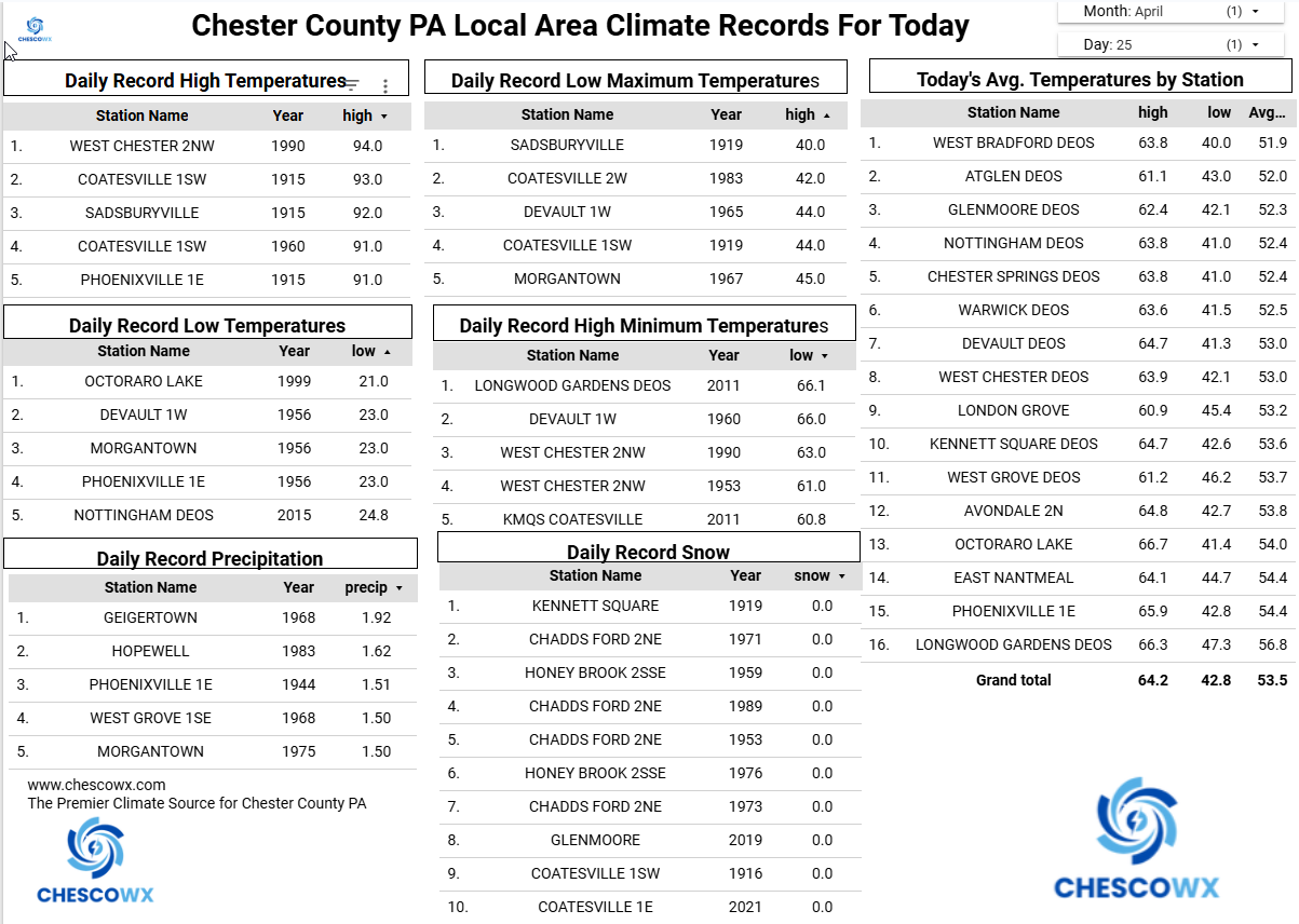
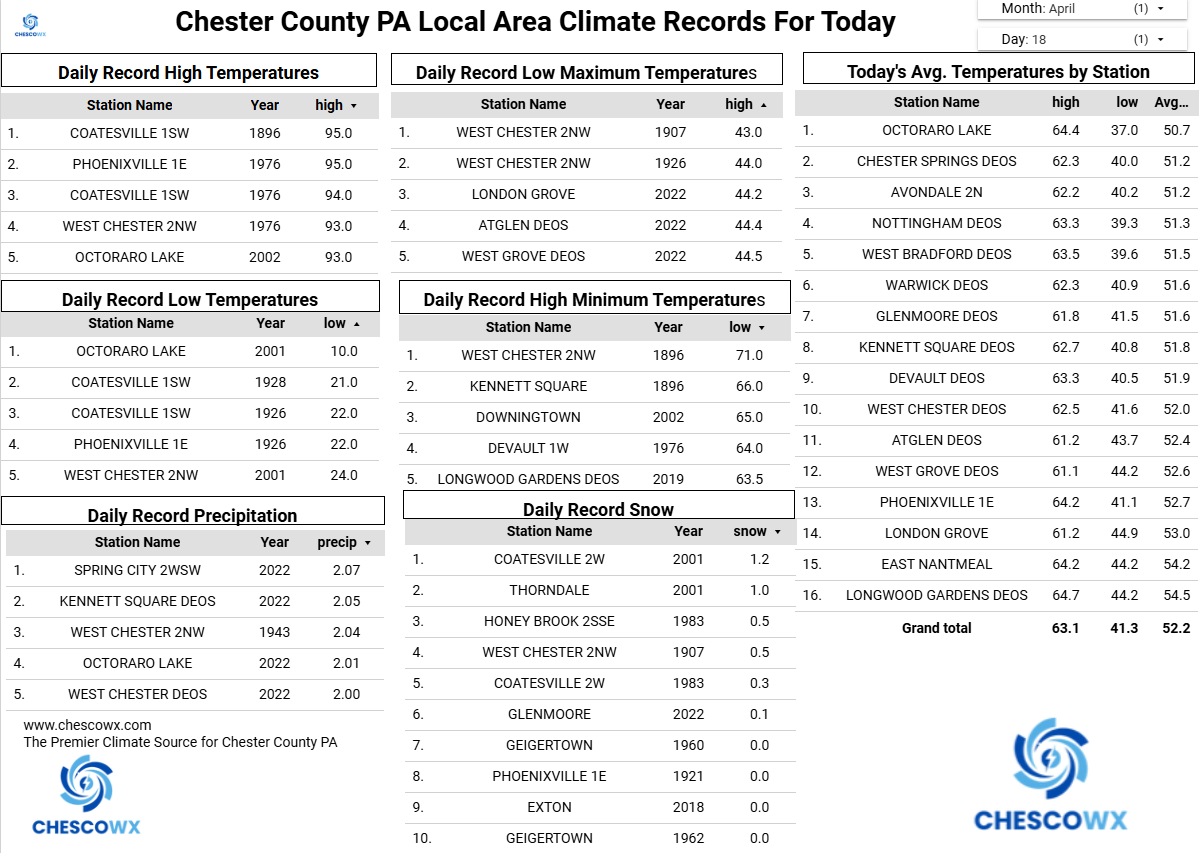
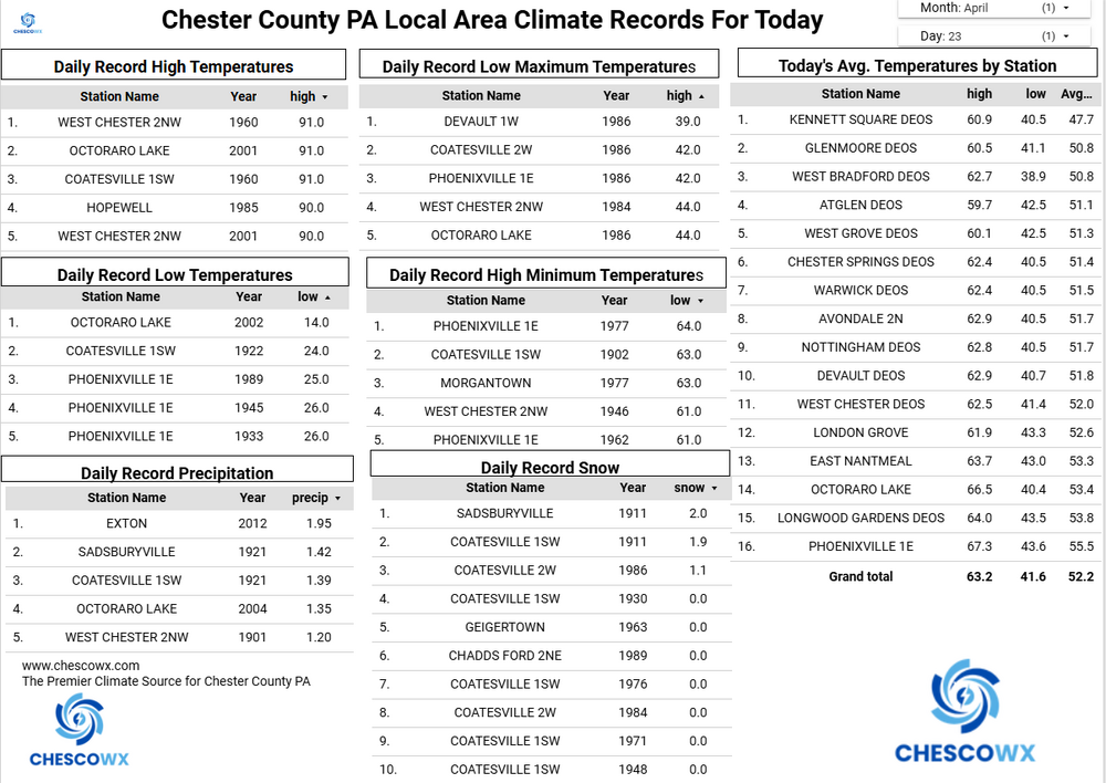
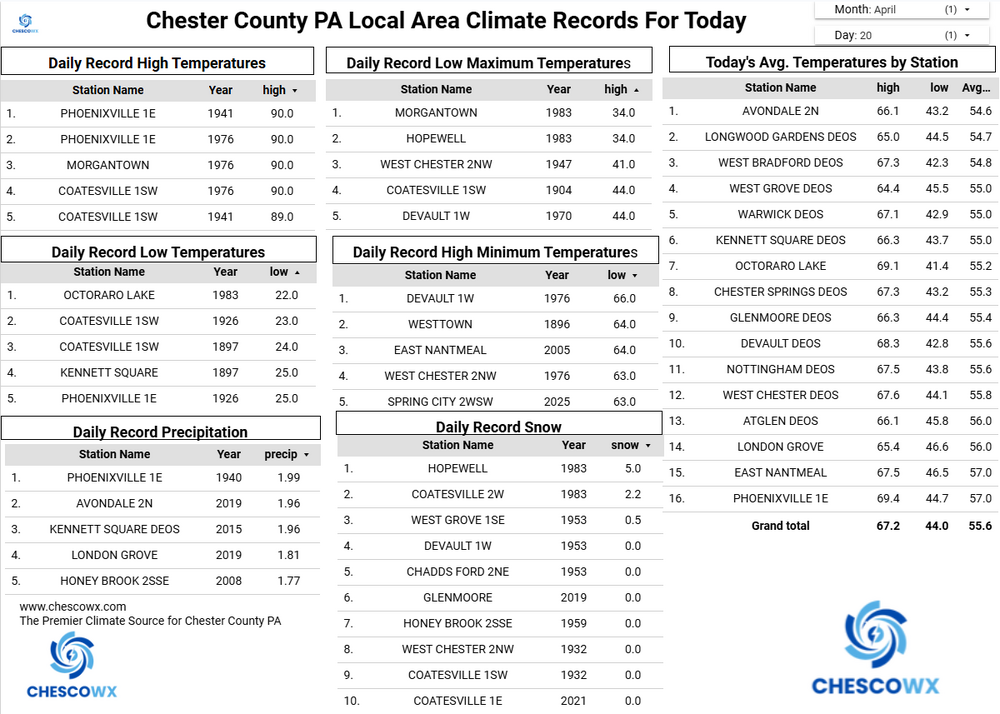
We had a widespread hard freeze (sub 28 degree) this morning with the latest sub-30-degree temperature I have ever recorded (records back to 2004) here in East Nantmeal with a low of 27.4. In looking back at records for the higher elevation spots (+600 ft ASL) of Chester County this appears to be the latest reading in the 20's in 37 years since the 27-degree reading at Coatesville 2W on April 24, 1989. Both KMQS Coatesville Airport and the Longwood Gardens DEOS station with 18 years of records also recorded their latest sub 30 degree reading this morning. In addition, many of our shorter-term stations with 15 years of records also set a record for latest hard freeze including DEOS stations in Atglen, Devault, Glenmoore, Kennett Square, Warwick, West Chester and West Grove. We stay unseasonable chilly through tomorrow with highs by tomorrow warming to near 60 degrees. We should see above normal temperatures by Thursday before we fall back below normal for the weekend. We have some light shower chances tomorrow morning with a better chance at more significant rains by Saturday.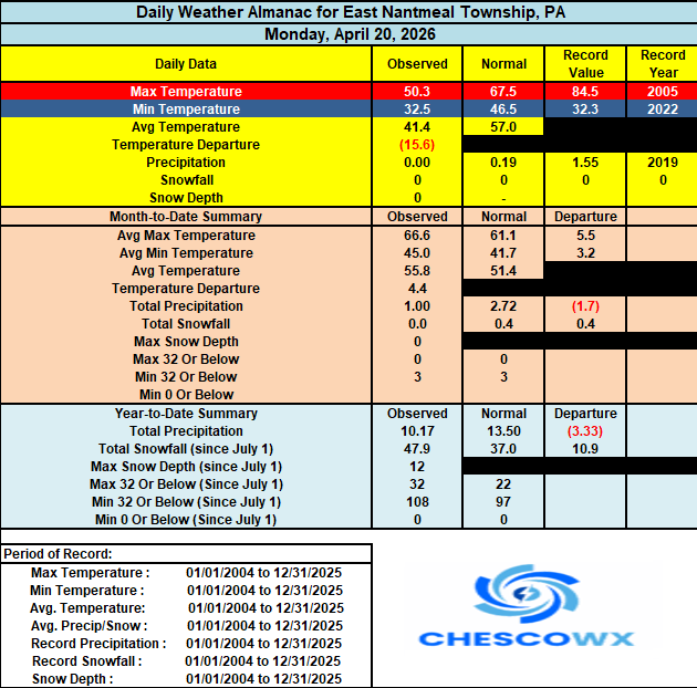

-
E PA/NJ/DE Spring 2026 Obs/Discussion
ChescoWx replied to PhiEaglesfan712's topic in Philadelphia Region
We had a widespread hard freeze (sub 28 degree) this morning with the latest sub-30-degree temperature I have ever recorded (records back to 2004) here in East Nantmeal with a low of 27.4. In looking back at records for the higher elevation spots (+600 ft ASL) of Chester County this appears to be the latest reading in the 20's in 37 years since the 27-degree reading at Coatesville 2W on April 24, 1989. Both KMQS Coatesville Airport and the Longwood Gardens DEOS station with 18 years of records also recorded their latest sub 30 degree reading this morning. In addition, many of our shorter-term stations with 15 years of records also set a record for latest hard freeze including DEOS stations in Atglen, Devault, Glenmoore, Kennett Square, Warwick, West Chester and West Grove. We stay unseasonable chilly through tomorrow with highs by tomorrow warming to near 60 degrees. We should see above normal temperatures by Thursday before we fall back below normal for the weekend. We have some light shower chances tomorrow morning with a better chance at more significant rains by Saturday.
-
E PA/NJ/DE Spring 2026 Obs/Discussion
ChescoWx replied to PhiEaglesfan712's topic in Philadelphia Region
Ugh! we missed out here in Chesco! So we will close our 2025-26 winter season with 15 winter events!! Actually Birds I am more efficient than you surmised with the entire Chester County data set on 2 cloud servers and an external drive. Spreadsheet wise - even more efficient with only 1 source excel spreadsheet mirrored on Google Sheets for analytics run off of Data Studio (a great analytics program by the way!) -
Truth! Only long running climate data works!
-
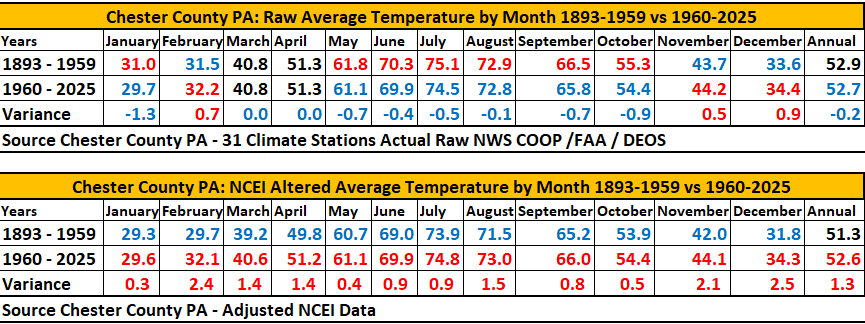
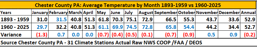
Due to multiple requests below for comparison I have added the recast National Centers for Environmental Information (NCEI) temperature data that includes the chilling adjustments to the older data. That chart is now below the actual raw data. I split our weather database almost down the middle to compare how our climate here in Chester County has changed compared to the first 66 years of climate data (1893-1959) vs. the last 67 years of data (1960-2025). With the actual data we see that 7 of our months have trended cooler - 3 have trended warmer and 2 have remained about the same. Overall, on an annual basis the actual raw data has trended cooler by 0.2 degrees during our most recent half of climate data 1960-2025. However, once NCEI applies their adjustments it paints a very different picture. We see clear warming in each and every month during our more recent climate history from 1960-2025. This aligns well with the expected warming narrative.
-
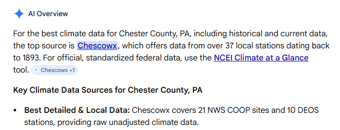
Well if AI says it's so.....
-
Central PA Spring 2026 Discussion/Obs Thread
ChescoWx replied to Voyager's topic in Upstate New York/Pennsylvania
A Freeze Warning is in effect tonight through 9am tomorrow morning. Be sure to protect any tender plants by late tonight. In my 22 years here the average date of my last freeze has been April 10th. Valley locations across the area have averaged later last freeze dates. High temperatures today will be almost 20 degrees below normal temperatures in the 40's. We start a warming trend through the rest of the work week before chilling down and turning wet for the weekend.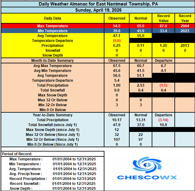
-
E PA/NJ/DE Spring 2026 Obs/Discussion
ChescoWx replied to PhiEaglesfan712's topic in Philadelphia Region
A Freeze Warning is in effect tonight through 9am tomorrow morning. Be sure to protect any tender plants by late tonight. In my 22 years here the average date of my last freeze has been April 10th. Valley locations across the area have averaged later last freeze dates. High temperatures today will be almost 20 degrees below normal temperatures in the 40's. We start a warming trend through the rest of the work week before chilling down and turning wet for the weekend.
-
I split our weather database almost down the middle to compare how our climate here in Chester County has changed compared to the first 66 years of climate data (1893-1959) vs. the last 67 years of data (1960-2025). Of note 7 months have trended cooler - 3 have trended warmer and 2 have remained about the same. Overall, on an annual basis we have trended cooler by 0.2 degrees during the latest period of record.
-
Central PA Spring 2026 Discussion/Obs Thread
ChescoWx replied to Voyager's topic in Upstate New York/Pennsylvania
I split our weather database almost down the middle to compare how our climate here in Chester County has changed compared to the first 66 years of climate data (1893-1959) vs. the last 67 years of data (1960-2025). Of note 7 months have trended cooler - 3 have trended warmer and 2 have remained about the same. Overall, on an annual basis we have trended cooler by 0.2 degrees during the latest period of record.
-
E PA/NJ/DE Spring 2026 Obs/Discussion
ChescoWx replied to PhiEaglesfan712's topic in Philadelphia Region
The correct answer remains as always - climate change!! LOL!! -
E PA/NJ/DE Spring 2026 Obs/Discussion
ChescoWx replied to PhiEaglesfan712's topic in Philadelphia Region
If looking to stay away from that summer like heat from this week....the ensemble models keep us below normal into May. -
Central PA Spring 2026 Discussion/Obs Thread
ChescoWx replied to Voyager's topic in Upstate New York/Pennsylvania
A much chillier day underway with showers across the area. We have already picked up 0.12" here in East Nantmeal with a little more on the way with shower chances continuing till about noon. Today’s temperatures will run about 20 degrees colder than normal with highs struggling to escape the 40's. Unseasonable cold tomorrow with highs again in the 40's. A freeze watch starts tomorrow night at midnight with lows by Tuesday morning in the low to mid 20's in the colder valley locations. We start a slow warming trend that lasts through the week with temperatures by Thursday near 70 degrees.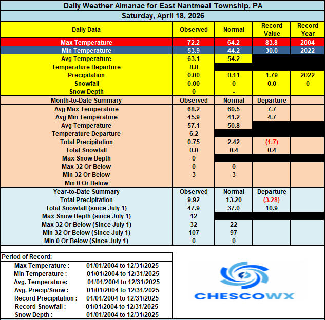
-
E PA/NJ/DE Spring 2026 Obs/Discussion
ChescoWx replied to PhiEaglesfan712's topic in Philadelphia Region
A much chillier day underway with showers across the area. We have already picked up 0.12" here in East Nantmeal with a little more on the way with shower chances continuing till about noon. Today’s temperatures will run about 20 degrees colder than normal with highs struggling to escape the 40's. Unseasonable cold tomorrow with highs again in the 40's. A freeze watch starts tomorrow night at midnight with lows by Tuesday morning in the low to mid 20's in the colder valley locations. We start a slow warming trend that lasts through the week with temperatures by Thursday near 70 degrees.
-
Central PA Spring 2026 Discussion/Obs Thread
ChescoWx replied to Voyager's topic in Upstate New York/Pennsylvania
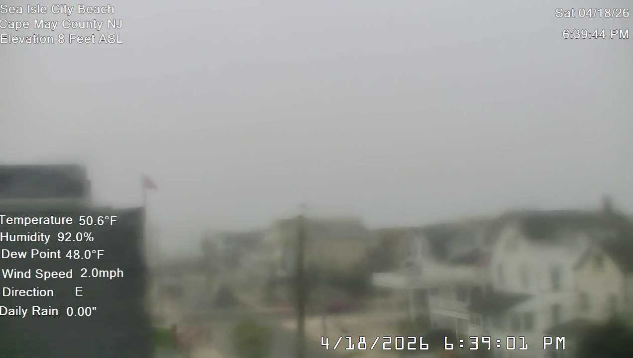
For those folks down the shore - the chilly ocean water temps working their unfortunate magic for folks down in Sea Isle City NJ for Girl's weekend....highs in SIC have not moved much from around 50 degrees all day. The beauty of coastal climes in the Northeast US in spring! Can hardly see through the fog and marine shank!
-
E PA/NJ/DE Spring 2026 Obs/Discussion
ChescoWx replied to PhiEaglesfan712's topic in Philadelphia Region
For those folks down the shore - the chilly ocean water temps working their unfortunate magic for folks down in Sea Isle City NJ for Girl's weekend....highs in SIC have not moved much from around 50 degrees all day. The beauty of coastal climes in the Northeast US in spring! Can hardly see through the fog and marine shank!
-
Central PA Spring 2026 Discussion/Obs Thread
ChescoWx replied to Voyager's topic in Upstate New York/Pennsylvania
Today will be our last above normal day though Wednesday. Today’s temperature will approach 70 degrees especially the further west you go. Tomorrow temperatures will struggle to escape the lower 50's. We should see some showers along the cold front during the morning tomorrow with between 0.10" to 0.40" of rain possible. By Monday temperatures in the higher spots will likely stay in the 40's with a freeze likely Monday night into Tuesday morning. We start to moderate with temperatures back to several degrees above normal in the low 70's by Friday.

-
E PA/NJ/DE Spring 2026 Obs/Discussion
ChescoWx replied to PhiEaglesfan712's topic in Philadelphia Region
Today will be our last above normal day though Wednesday. Today’s temperature will approach 70 degrees especially the further west you go. Tomorrow temperatures will struggle to escape the lower 50's. We should see some showers along the cold front during the morning tomorrow with between 0.10" to 0.40" of rain possible. By Monday temperatures in the higher spots will likely stay in the 40's with a freeze likely Monday night into Tuesday morning. We start to moderate with temperatures back to several degrees above normal in the low 70's by Friday.