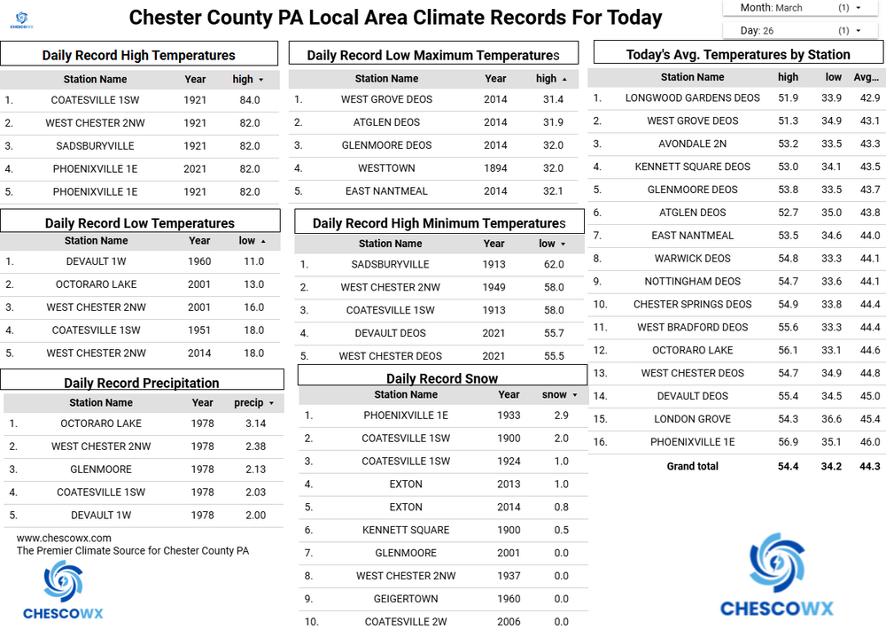
(002).png.f2cbd7c955dc3007a02ab79925b174ec.png)
ChescoWx
-
Posts
11,175 -
Joined
-
Last visited
Content Type
Profiles
Blogs
Forums
American Weather
Media Demo
Store
Gallery
Everything posted by ChescoWx
-
(002).thumb.png.6e3d9d46bca5fe41aab7a74871dd8af8.png) Charlie again you are not following! If after the 1948 move it was colder than the City of Coatesville riddle me why they continued the same chilling adjustment to the newer chillier location? Not just for 1 year but for every year but 1 from 1948 through 1971. Even more bizarre can you explain why those NCEI number in 15 of the 20 years from 1952 thru 1971 were actually adjusted by NCEI to averages even lower than the high elevation station in Morgantown? Where is the control arm station that figures let's cool down the new chiller station location to even colder than a higher elevation further north station? There is absolutely zero support for these adjustments! 1948 51.2 50.0 (1.1) 1949 53.4 52.6 (0.8) 1950 51.1 50.8 (0.3) 1951 52.2 51.2 (1.0) 1952 52.4 51.6 (0.8) 1953 53.7 52.8 (1.0) 1954 52.3 51.8 (0.6) 1955 52.3 51.9 (0.5) 1956 51.3 49.6 (1.7) 1957 52.6 52.0 (0.6) 1958 50.2 50.2 0.0 1959 53.5 51.8 (1.8) 1960 51.7 51.2 (0.5) 1961 52.3 50.4 (1.9) 1962 51.0 49.8 (1.2) 1963 50.7 49.5 (1.2) 1964 51.8 49.8 (2.0) 1965 51.8 50.3 (1.5) 1966 51.4 50.3 (1.2) 1967 51.1 49.6 (1.5) 1968 51.9 50.8 (1.1) 1969 51.5 50.2 (1.3) 1970 51.5 49.8 (1.7) 1971 51.7 50.7 (1.0)
Charlie again you are not following! If after the 1948 move it was colder than the City of Coatesville riddle me why they continued the same chilling adjustment to the newer chillier location? Not just for 1 year but for every year but 1 from 1948 through 1971. Even more bizarre can you explain why those NCEI number in 15 of the 20 years from 1952 thru 1971 were actually adjusted by NCEI to averages even lower than the high elevation station in Morgantown? Where is the control arm station that figures let's cool down the new chiller station location to even colder than a higher elevation further north station? There is absolutely zero support for these adjustments! 1948 51.2 50.0 (1.1) 1949 53.4 52.6 (0.8) 1950 51.1 50.8 (0.3) 1951 52.2 51.2 (1.0) 1952 52.4 51.6 (0.8) 1953 53.7 52.8 (1.0) 1954 52.3 51.8 (0.6) 1955 52.3 51.9 (0.5) 1956 51.3 49.6 (1.7) 1957 52.6 52.0 (0.6) 1958 50.2 50.2 0.0 1959 53.5 51.8 (1.8) 1960 51.7 51.2 (0.5) 1961 52.3 50.4 (1.9) 1962 51.0 49.8 (1.2) 1963 50.7 49.5 (1.2) 1964 51.8 49.8 (2.0) 1965 51.8 50.3 (1.5) 1966 51.4 50.3 (1.2) 1967 51.1 49.6 (1.5) 1968 51.9 50.8 (1.1) 1969 51.5 50.2 (1.3) 1970 51.5 49.8 (1.7) 1971 51.7 50.7 (1.0) -
Central PA Spring 2026 Discussion/Obs Thread
ChescoWx replied to Voyager's topic in Upstate New York/Pennsylvania
Today will be our first above normal temperature day since Easter Sunday. We should see some sun later today with temperatures well into the 60's. We chill back to normal temperatures over the weekend with highs in the low 60's before a big warmup next week. The warmest day here in Chester County looks to be Wednesday with highs in the low to mid 80's (1st 90+ possible near the Philly heat island area) Temperatures start to cool a bit later next week. Sadly, no rain in the forecast at all!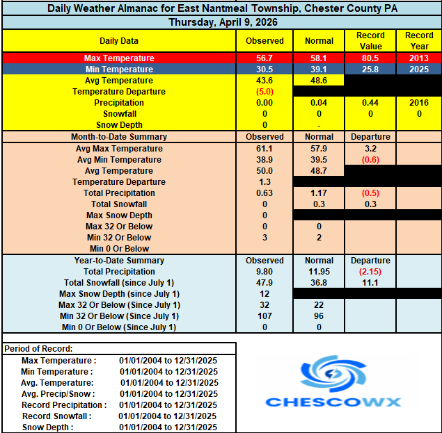

-
E PA/NJ/DE Spring 2026 Obs/Discussion
ChescoWx replied to PhiEaglesfan712's topic in Philadelphia Region
Today will be our first above normal temperature day since Easter Sunday. We should see some sun later today with temperatures well into the 60's. We chill back to normal temperatures over the weekend with highs in the low 60's before a big warmup next week. The warmest day here in Chester County looks to be Wednesday with highs in the low to mid 80's (1st 90+ possible near the Philly heat island area) Temperatures start to cool a bit later next week. Sadly, no rain in the forecast at all!
-
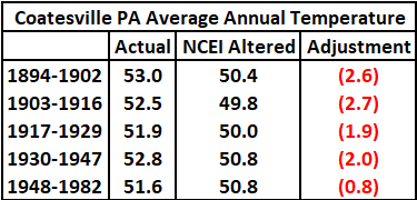
Easily disproved by the actual NCEI adjustments made - see below. Based on what you show above there was no need for cooling from 1941-1946 yet look at what NCEI did...actual raw on left adjustment on left. 47 1940 49.1 47.6 (1.5) 48 1941 53.8 51.6 (2.2) 49 1942 53.6 51.3 (2.3) 50 1943 53.4 50.4 (3.0) 51 1944 53.8 51.2 (2.7) 52 1945 53.6 50.8 (2.8) 53 1946 53.5 51.3 (2.2)
-
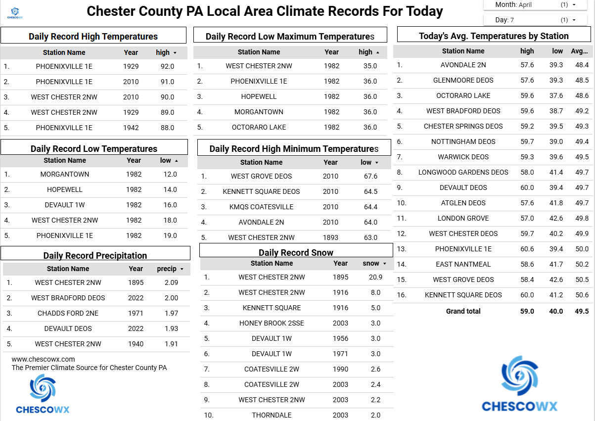
On X today ABC Chief Meteorologist Ginger Zee answered a message I sent to her regarding the controversial NCEI temperature adjustments that have been made to the actual historical raw NWS Cooperative Data. Below is her response and a link with her "deep dive" report on the controversy. To be honest her report for the most part simply repeated the standard response saying "the science supports it" which is what you will always hear. For many folks with that answer from a professional meteorologist, they will simply nod their heads and say well if the science says it must be so. This in most cases will often stop any further questioning of the data. To Ginger's credit she agrees with my long-held stance in the video that science should always be questioned and evaluated. I certainly have questions and have to date not found any solid support for the consistent 2-to-3-degree chilling of the old data for every single year from 1895 through 2000. So, I will continue to question these adjustments. Science is always about questioning data not blindly following! https://t.co/e5CFYdO803 Below is my response to Ginger with the data to try and support any adjustments to the raw data. Thanks Ginger but you didn't get into the deeper detail as to the explanation for the changes made to not only the ASOS sites at Airports you mentioned but to the NWS Cooperative Observer Data. A case in point is the long running Coatesville 1SW NWS Cooperative Station data for the philly burbs of Chester County PA with data from 1894 through 1983. There are many reasons given for these post observation ad hoc adjustments. The most common are station moves and time of observation adjustments. Below shows that for this station NCEI chilled 86 of the 89 years between 1894 through 1982. Below are the station moves grouped by year. These were all within a couple miles in each case with annual clear consistent cooling adjustments applied to the raw data. The time of observation adjustment also is not relevant in this case as only for 11 years (1910-21) was the daily observation taken only in the evening. So how and why exactly was this particular station chilled so consistently across 97% of all years?

-
Central PA Spring 2026 Discussion/Obs Thread
ChescoWx replied to Voyager's topic in Upstate New York/Pennsylvania
Another widespread freeze this morning across the area with our lowest Chesco climate station the 24.7 at the Warwick DEOS. We remain well below normal today with highs in the middle 50’s, but a nice warming trend kicks in starting tomorrow and we get very warm with low 80's possible by next Tuesday and Wednesday! We could use a little rain but nothing in sight over the next week.
-
E PA/NJ/DE Spring 2026 Obs/Discussion
ChescoWx replied to PhiEaglesfan712's topic in Philadelphia Region
Another widespread freeze this morning across the area with our lowest Chesco climate station the 24.7 at the Warwick DEOS. We remain well below normal today with highs in the middle 50’s, but a nice warming trend kicks in starting tomorrow and we get very warm with low 80's possible by next Tuesday and Wednesday! We could use a little rain but nothing in sight over the next week.
-
Central PA Spring 2026 Discussion/Obs Thread
ChescoWx replied to Voyager's topic in Upstate New York/Pennsylvania
East Nantmeal broke it’s record low this morning with a low of 25.9. The old record was 27.8 set back in 2007. While a short-term record here since 2004 nowhere close to record across the county. The lowest reading I could find this morning was the 21.6 at our typical cold spot in Warwick Township. Another well below normal temperature day with highs struggling into to the low 50’s. Another freeze potential tonight before we start a slow warming trend to near normal temperatures by the weekend with highs in the low 60’s. We should see well above normal temperatures early next week before another cool down sets in by the end of next week. No real rain chances through the week.
-
E PA/NJ/DE Spring 2026 Obs/Discussion
ChescoWx replied to PhiEaglesfan712's topic in Philadelphia Region
East Nantmeal broke it’s record low this morning with a low of 25.9. The old record was 27.8 set back in 2007. While a short-term record here since 2004 nowhere close to record across the county. The lowest reading I could find this morning was the 21.6 at our typical cold spot in Warwick Township. Another well below normal temperature day with highs struggling into to the low 50’s. Another freeze potential tonight before we start a slow warming trend to near normal temperatures by the weekend with highs in the low 60’s. We should see well above normal temperatures early next week before another cool down sets in by the end of next week. No real rain chances through the week.
-
Central PA Spring 2026 Discussion/Obs Thread
ChescoWx replied to Voyager's topic in Upstate New York/Pennsylvania
Some unseasonably cold temperatures through mid-week including a hard freeze tomorrow night into Wednesday morning. Temperatures will remain in the upper 40's which is a solid 10 degrees below normal for the date. We slowly modify to slightly above normal temperatures with highs in the mid to upper 60's by the weekend. Looking ahead to next week we should see a big warmup well into the 70's before another cool down back to below normal temperatures by late next week. Overall, a dry pattern throughout the period.

-
E PA/NJ/DE Spring 2026 Obs/Discussion
ChescoWx replied to PhiEaglesfan712's topic in Philadelphia Region
Some unseasonably cold temperatures through mid-week including a hard freeze tomorrow night into Wednesday morning. Temperatures will remain in the upper 40's which is a solid 10 degrees below normal for the date. We slowly modify to slightly above normal temperatures with highs in the mid to upper 60's by the weekend. Looking ahead to next week we should see a big warmup well into the 70's before another cool down back to below normal temperatures by late next week. Overall, a dry pattern throughout the period. Albedoman will not be pleased!
-
Central PA Spring 2026 Discussion/Obs Thread
ChescoWx replied to Voyager's topic in Upstate New York/Pennsylvania
Happy Easter to all who celebrate! Many lower elevation spots reached the lower 80's yesterday. While higher spots remained below 80 degrees, we did set a record high for my East Nantmeal station yesterday breaking the old record from 2011 by almost 5 degrees. However, the Chester County record from 1963 of 84 degrees at West Grove was not reached by any of the record stations across the County. With our backdoor cold front temperatures have fallen below forecasted levels to well down into the 40's across the area. We may struggle to get much above 60 degrees today. We turn much chillier tonight with well below normal temperatures through Wednesday. There is the potential of a hard freeze by Wednesday morning. Shower chances are around today but dry for much of the upcoming work week.
-
E PA/NJ/DE Spring 2026 Obs/Discussion
ChescoWx replied to PhiEaglesfan712's topic in Philadelphia Region
Happy Easter to all who celebrate! Many lower elevation spots reached the lower 80's yesterday. While higher spots remained below 80 degrees, we did set a record high for my East Nantmeal station yesterday breaking the old record from 2011 by almost 5 degrees. However, the Chester County record from 1963 of 84 degrees at West Grove was not reached by any of the record stations across the County. With our backdoor cold front temperatures have fallen below forecasted levels to well down into the 40's across the area. We may struggle to get much above 60 degrees today. We turn much chillier tonight with well below normal temperatures through Wednesday. There is the potential of a hard freeze by Wednesday morning. Shower chances are around today but dry for much of the upcoming work week.
-
Central PA Spring 2026 Discussion/Obs Thread
ChescoWx replied to Voyager's topic in Upstate New York/Pennsylvania
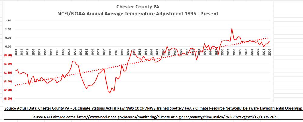
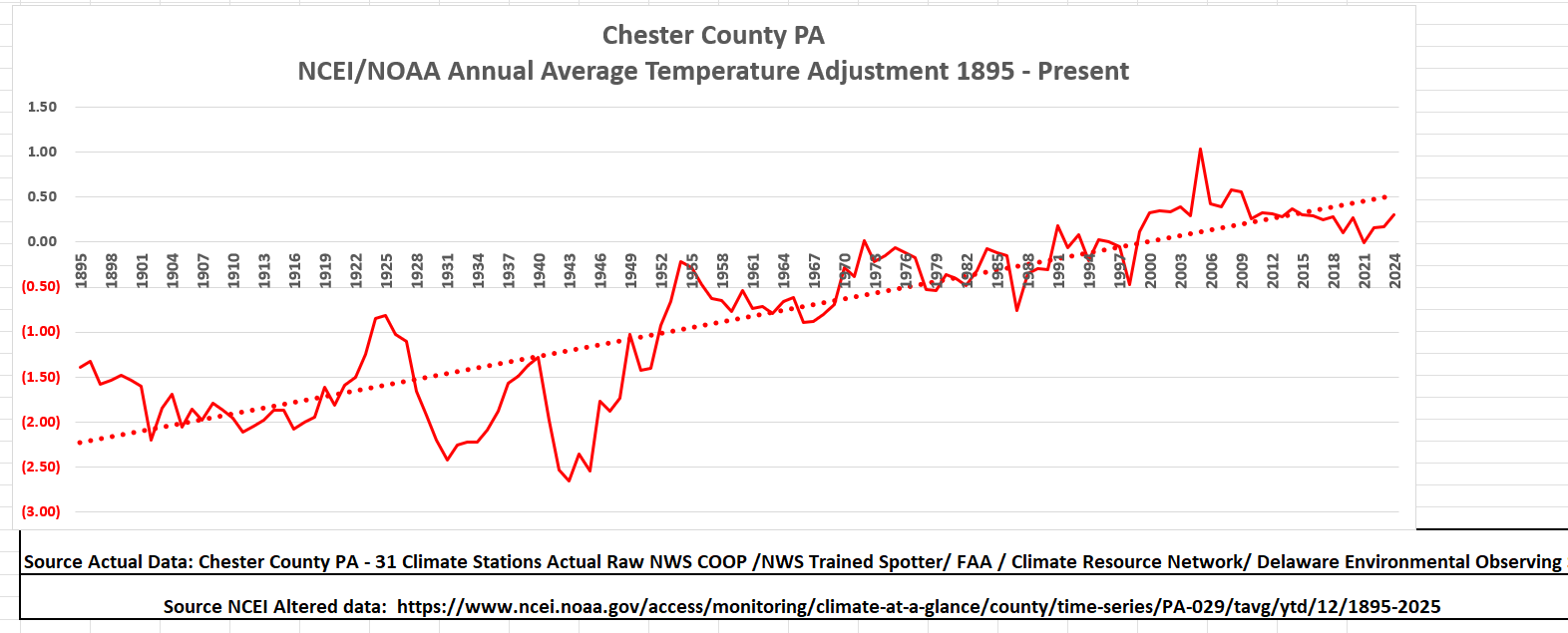
March 2026 finished as our 18th warmest March since 1894 here in Chester County PA. The top 5 warmest March months are below. I also have attached the average temperature trends for March since 1894. Blue is raw and Red in NOAA altered adjusted temperatures.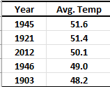
-
E PA/NJ/DE Spring 2026 Obs/Discussion
ChescoWx replied to PhiEaglesfan712's topic in Philadelphia Region
March 2026 finished as our 18th warmest March since 1894 here in Chester County PA. The top 5 warmest March months are below. I also have attached the average temperature trends for March since 1894. Blue is raw and Red in NOAA altered adjusted temperatures.
-
No warming or cooling is my point you miss - just typical cyclical normal climate changes FTW!!
-
Central PA Spring 2026 Discussion/Obs Thread
ChescoWx replied to Voyager's topic in Upstate New York/Pennsylvania
We will finish March with our 1st above normal temperature month since way back in September. Every fall and winter month except September ended with below normal temperatures. Our seesaw temperatures typical of spring will continue over the next several days. We have a well above normal day today before we turn much chiller tomorrow. We warm again by Friday through the weekend before turning much cooler again to start the new work week. Rain chances to really ramp up tomorrow into Wednesday night.
-
E PA/NJ/DE Spring 2026 Obs/Discussion
ChescoWx replied to PhiEaglesfan712's topic in Philadelphia Region
We will finish March with our 1st above normal temperature month since way back in September. Every fall and winter month except September ended with below normal temperatures. Our seesaw temperatures typical of spring will continue over the next several days. We have a well above normal day today before we turn much chiller tomorrow. We warm again by Friday through the weekend before turning much cooler again to start the new work week. Rain chances to really ramp up tomorrow into Wednesday night.
-
bdgwx just keep on cherry picking - you will always get the anwer you want!!
-
Poor Cobalt!! Little does he seem to know.....
-
Cherry picking always gives the desired answer.....
-
Central PA Spring 2026 Discussion/Obs Thread
ChescoWx replied to Voyager's topic in Upstate New York/Pennsylvania
To those that celebrate....welcome to Phillies Opening Day!! Go Phillies! It will be a beautiful spring day today with highs reaching the 70's. Shower chances increase tonight into tomorrow morning. Much colder tomorrow with temperatures falling during the day and falling below freezing tomorrow night. Saturday will be the coldest day of the weekend with highs barely escaping the 30's. We moderate back to near normal temperatures by Sunday. Go Phillies!!
-
E PA/NJ/DE Spring 2026 Obs/Discussion
ChescoWx replied to PhiEaglesfan712's topic in Philadelphia Region
To those that celebrate....welcome to Phillies Opening Day!! Go Phillies! It will be a beautiful spring day today with highs reaching the 70's. Shower chances increase tonight into tomorrow morning. Much colder tomorrow with temperatures falling during the day and falling below freezing tomorrow night. Saturday will be the coldest day of the weekend with highs barely escaping the 30's. We moderate back to near normal temperatures by Sunday. Go Phillies!!
-
Central PA Spring 2026 Discussion/Obs Thread
ChescoWx replied to Voyager's topic in Upstate New York/Pennsylvania
Hi Jns, Attached is a link to my website with the site descriptions. They are a combination of NWS COOP / CRN / AWOS / DEOS stations. No Cocorahs are included - but I may in the future. Let me know if any other questions. Thanks! Paul https://chescowx.com/detailed-station-data/ -
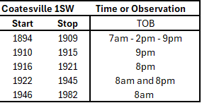
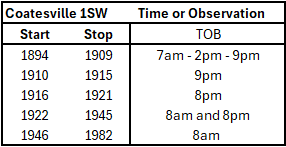
Many climate alarmist like to point to the Time of Observation Bias (TOB) as solid "scientific adjustments" required to correct that bias. NOAA/NCEI in fact chose to chill every year at Coatesville from 1895 thru 1982. However, if anything when we look at the facts of when these observations were taken (see the below of COOP observation time/years) we see that with the exception of 11 years.... temperatures were in reality recorded in the morning. So if their rationale is correct the bias for Coatesville should in fact be too cool with all of those AM minimum temperature reports. Yet they chose to not warm those years - they actually made additional chilling adjustments.