(002).png.f2cbd7c955dc3007a02ab79925b174ec.png)
ChescoWx
-
Posts
11,175 -
Joined
-
Last visited
Content Type
Profiles
Blogs
Forums
American Weather
Media Demo
Store
Gallery
Everything posted by ChescoWx
-
(002).thumb.png.6e3d9d46bca5fe41aab7a74871dd8af8.png)
Central PA Spring 2026 Discussion/Obs Thread
ChescoWx replied to Voyager's topic in Upstate New York/Pennsylvania
The Devault DEOS station recorded a high of 90.7 yesterday this is the first 90 degree reading at any County station so far this year. None of the other stations reached 90 but upper 80's were common across the valley locations. Today should be 10 to 12 degrees cooler with highs in the mid to upper 70's. This is still 10+ degrees above normal levels. We chill well below normal by Sunday with highs remaining in the low to mid 50's with shower chances increasing. A freeze remains a possibility by Tuesday morning.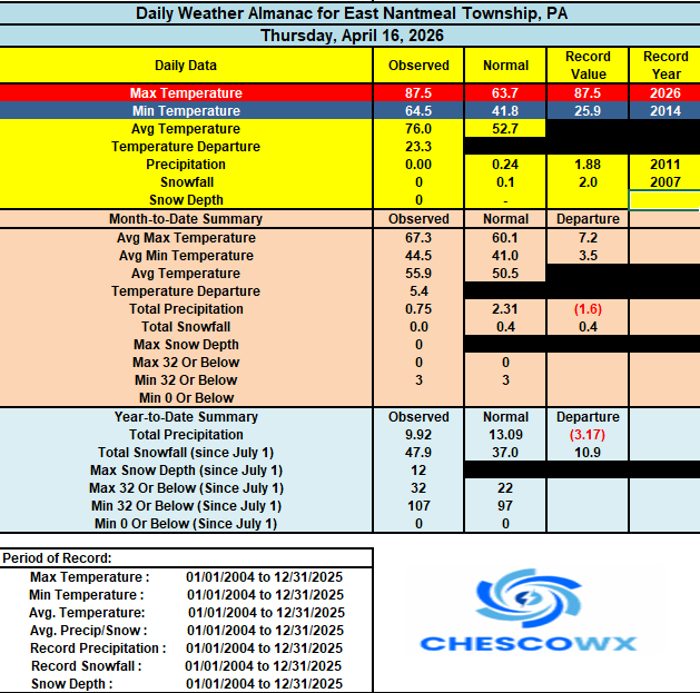
-
E PA/NJ/DE Spring 2026 Obs/Discussion
ChescoWx replied to PhiEaglesfan712's topic in Philadelphia Region
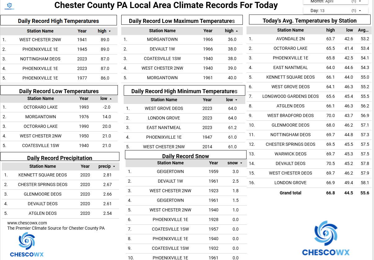
Warmest day of the year 87.5 for the high in East Nantmeal -
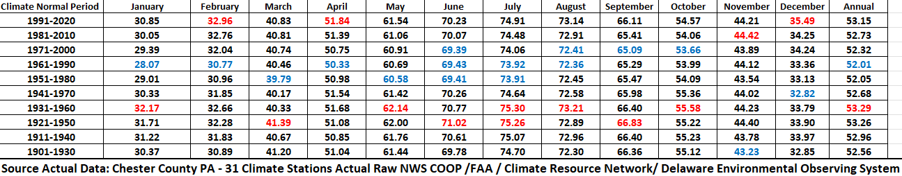
As per the World Meteorological Organization (WMO) Current climate normals are calculated using the past 3 complete decades and recalculated every 10 years. So, I went back and calculated what was normal for the last 10 climate normal periods specifically for Chester County PA. The below show what the climate normals were for the 10 years following each calculation with the earliest being 1901-1930 normals and the latest being our current climate normal period of 1991-2020. Averages in red are the warmest and blue the coolest across those periods. Of note our warmest climate normal period was 1931-1960 and our coolest period was 1961-1990.

-
Central PA Spring 2026 Discussion/Obs Thread
ChescoWx replied to Voyager's topic in Upstate New York/Pennsylvania
As per the World Meteorological Organization (WMO) Current climate normals are calculated using the past 3 complete decades and recalculated every 10 years. So, I went back and calculated what was normal for the last 10 climate normal periods specifically for Chester County PA. The below show what the climate normals were for the 10 years following each calculation with the earliest being 1901-1930 normals and the latest being our current climate normal period of 1991-2020. Averages in red are the warmest and blue the coolest across those periods. Of note our warmest climate normal period was 1931-1960 and our coolest period was 1961-1990.
-
E PA/NJ/DE Spring 2026 Obs/Discussion
ChescoWx replied to PhiEaglesfan712's topic in Philadelphia Region
As per the World Meteorological Organization (WMO) Current climate normals are calculated using the past 3 complete decades and recalculated every 10 years. So, I went back and calculated what was normal for the last 10 climate normal periods specifically for Chester County PA. The below show what the climate normals were for the 10 years following each calculation with the earliest being 1901-1930 normals and the latest being our current climate normal period of 1991-2020. Averages in red are the warmest and blue the coolest across those periods. Of note our warmest climate normal period was 1931-1960 and our coolest period was 1961-1990.
-
Central PA Spring 2026 Discussion/Obs Thread
ChescoWx replied to Voyager's topic in Upstate New York/Pennsylvania
Today will be out last day with temperatures in the 80’s with highs in some valley spots getting within a couple degrees of 90. We fall back into the 70’s tomorrow and Saturday before we fall back below normal by Sunday through next Tuesday. Some shower chances later tomorrow and a better chance on Saturday night. We could have some freeze or frost concerns by Monday night into Tuesday morning.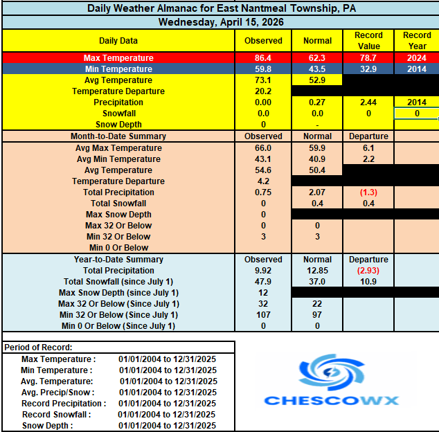

-
E PA/NJ/DE Spring 2026 Obs/Discussion
ChescoWx replied to PhiEaglesfan712's topic in Philadelphia Region
Today will be our last day with temperatures in the 80’s with highs in some valley spots getting within a couple degrees of 90. We fall back into the 70’s tomorrow and Saturday before we fall back below normal by Sunday through next Tuesday. Some shower chances later tomorrow and a better chance on Saturday night. We could have some freeze or frost concerns by Monday night into Tuesday morning.
-
E PA/NJ/DE Spring 2026 Obs/Discussion
ChescoWx replied to PhiEaglesfan712's topic in Philadelphia Region
I remember this well! I was playing in a stickball marathon in philly and received the worst sunburn of my life! memories..... -
E PA/NJ/DE Spring 2026 Obs/Discussion
ChescoWx replied to PhiEaglesfan712's topic in Philadelphia Region
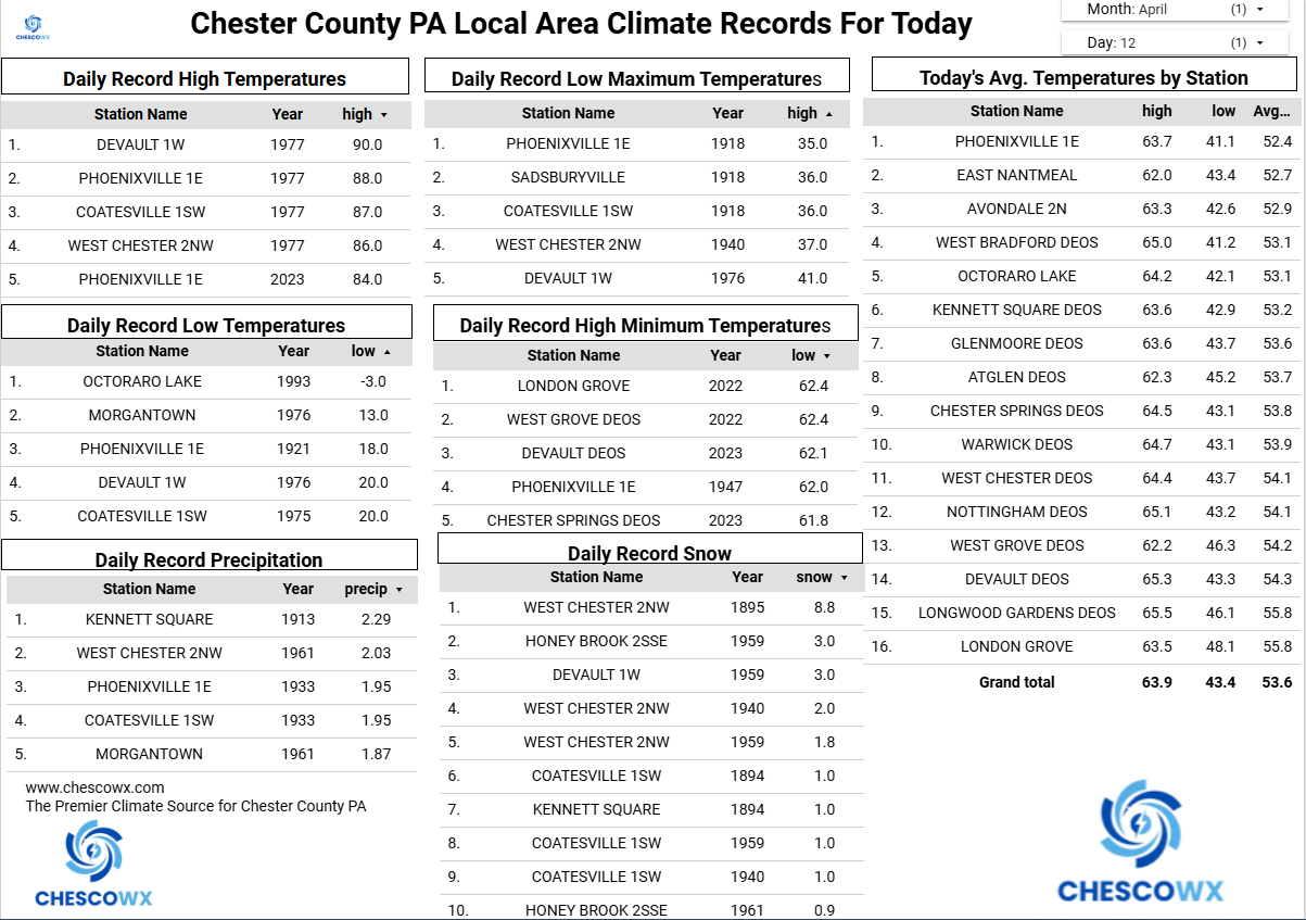
Here in Chester County so far no climate stations have touched 90 this month. The last time we hit 90 in the month of April in Chesco was April 7, 2010 when it hit 91 at Phoenixville 1E. The earliest 90+ day in County history was way back on March 22, 1948 with a 90 at Phoenixville 1E -
Central PA Spring 2026 Discussion/Obs Thread
ChescoWx replied to Voyager's topic in Upstate New York/Pennsylvania
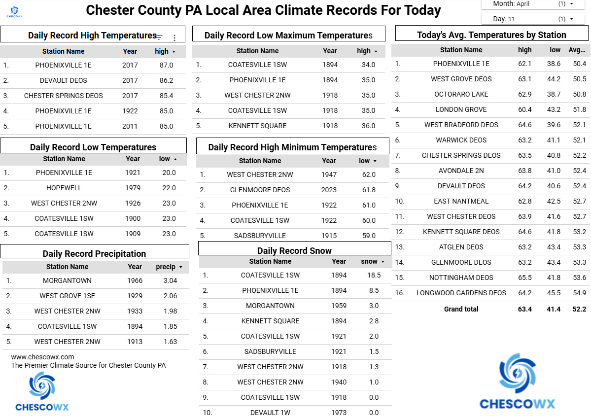
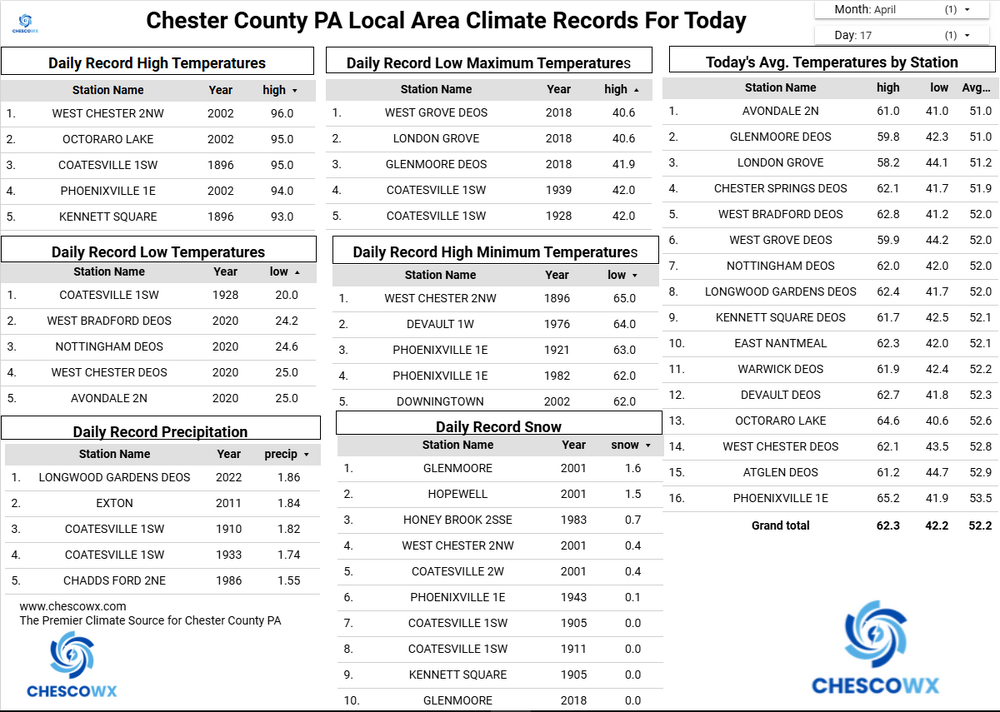
We picked up between 0.03" to 0.25" of rain with more across southern areas. Today will be our warmest day of the week and the year so far with temperatures reaching the middle to upper 80's. The record County high for today is 89 degrees set back in 1941 (Phoenixville) and 1896 (Kennett Square). Still unseasonable warm tomorrow through Saturday. We chill back to below normal by Monday and temperatures in some of the higher spots may struggle to escape the unseasonably cold 40's in the afternoon. There will also be a potential for a frost or freeze by Tuesday morning. Below normal temperatures appear increasingly likely for the remainder of April. Best chances of some much-needed rain looks to be Friday with better chances with the cold front on Sunday afternoon.

-
E PA/NJ/DE Spring 2026 Obs/Discussion
ChescoWx replied to PhiEaglesfan712's topic in Philadelphia Region
We picked up between 0.03" to 0.25" of rain with more across southern areas. Today will be our warmest day of the week and the year so far with temperatures reaching the middle to upper 80's. The record County high for today is 89 degrees set back in 1941 (Phoenixville) and 1896 (Kennett Square). Still unseasonable warm tomorrow through Saturday. We chill back to below normal by Monday and temperatures in some of the higher spots may struggle to escape the unseasonably cold 40's in the afternoon. There will also be a potential for a frost or freeze by Tuesday morning. Below normal temperatures appear increasingly likely for the remainder of April. Best chances of some much-needed rain looks to be Friday with better chances with the cold front on Sunday afternoon.
-
Central PA Spring 2026 Discussion/Obs Thread
ChescoWx replied to Voyager's topic in Upstate New York/Pennsylvania
Well above normal temperatures continue through Saturday before we see another pattern change to normal to below average temperatures lasting through much of the rest of the month. The warmest day looks like Wednesday with highs in the mid to upper 80's. Shower chances increase Friday night and especially Saturday night into Sunday with the cold front. Temperatures by next Monday may struggle to escape the mid-50's.
-
E PA/NJ/DE Spring 2026 Obs/Discussion
ChescoWx replied to PhiEaglesfan712's topic in Philadelphia Region
Well above normal temperatures continue through Saturday before we see another pattern change to normal to below average temperatures lasting through much of the rest of the month. The warmest day looks like Wednesday with highs in the mid to upper 80's. Shower chances increase Friday night and especially Saturday night into Sunday with the cold front. Temperatures by next Monday may struggle to escape the mid-50's.
-
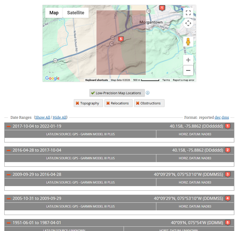
"That is a clear sign of a major station change, probably at Morgantown." That would be incorrect Charlie no station changes took place at all during the period that temperatures were reported by the NWS Coop observer. There were some moves after those temperature obs ended and they moved to just precip and snow obs.
-
Central PA Spring 2026 Discussion/Obs Thread
ChescoWx replied to Voyager's topic in Upstate New York/Pennsylvania
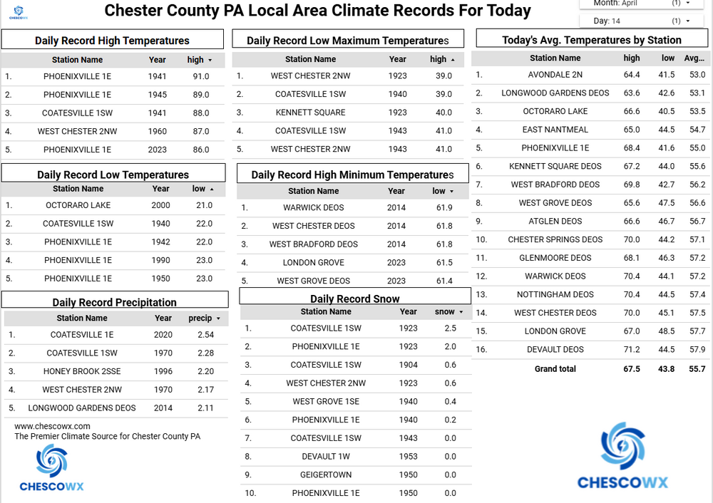
We start our major warm up today with temperatures reaching well into the 70's. We warm into the 80's on Tuesday with our warmest days both Wednesday and Thursday. While places along the I95 corridor could see record highs in the 90's it looks like we should stay in the middle 80's here in Chester County. Our Chester County record high for Wednesday is 89 degrees set in Phoenixville way back in 1941. Thursday's record high is 92 degrees set at multiple county stations back in 1896 and 2002. We have a slight chance of showers this afternoon and again on Wednesday night, but our best chance of any showers looks to arrive on Saturday night.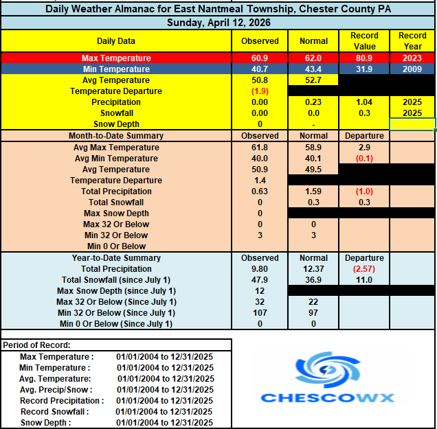

-
E PA/NJ/DE Spring 2026 Obs/Discussion
ChescoWx replied to PhiEaglesfan712's topic in Philadelphia Region
We start our major warm up today with temperatures reaching well into the 70's. We warm into the 80's on Tuesday with our warmest days both Wednesday and Thursday. While places along the I95 corridor could see record highs in the 90's it looks like we should stay in the middle 80's here in Chester County. Our Chester County record high for Wednesday is 89 degrees set in Phoenixville way back in 1941. Thursday's record high is 92 degrees set at multiple county stations back in 1896 and 2002. We have a slight chance of showers this afternoon and again on Wednesday night, but our best chance of any showers looks to arrive on Saturday night.
-
Even vs. Morgantown a few hundred feet higher we see the same telltale pattern of chilling the past - altering those stations below what any actual station shows for the area.

-
Central PA Spring 2026 Discussion/Obs Thread
ChescoWx replied to Voyager's topic in Upstate New York/Pennsylvania
Another near normal temperature day today with highs around 60 degrees before we see much warmer weather moving in tomorrow and lasting much of the upcoming work week. The warmest day looks to be Wednesday with highs in the middle 80's. We have a slight chance of some showers both tomorrow night and again on Wednesday night.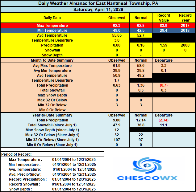

-
E PA/NJ/DE Spring 2026 Obs/Discussion
ChescoWx replied to PhiEaglesfan712's topic in Philadelphia Region
Another near normal temperature day today with highs around 60 degrees before we see much warmer weather moving in tomorrow and lasting much of the upcoming work week. The warmest day looks to be Wednesday with highs in the middle 80's. We have a slight chance of some showers both tomorrow night and again on Wednesday night.
-
Central PA Spring 2026 Discussion/Obs Thread
ChescoWx replied to Voyager's topic in Upstate New York/Pennsylvania
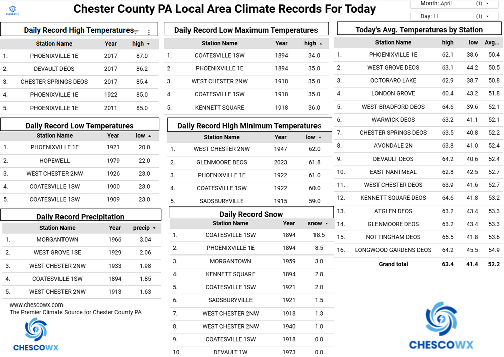
Today way back in 1894 Chester County shoveled out of the largest April snowstorm in County history with over a foot of snow across much of the county including 29.2" at the Coatesville 1SW NWS cooperative observer station. Nothing like that in our future this April as after near normal temperatures around 60 degrees both today and tomorrow we start a nice warmup peaking with high temperatures in the mid 80's both Wednesday and Thursday. Our best chances of showers arrive by the end of the upcoming work week.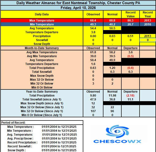
-
E PA/NJ/DE Spring 2026 Obs/Discussion
ChescoWx replied to PhiEaglesfan712's topic in Philadelphia Region
Today way back in 1894 Chester County shoveled out of the largest April snowstorm in County history with over a foot of snow across much of the county including 29.2" at the Coatesville 1SW NWS cooperative observer station. Nothing like that in our future this April as after near normal temperatures around 60 degrees both today and tomorrow we start a nice warmup peaking with high temperatures in the mid 80's both Wednesday and Thursday. Our best chances of showers arrive by the end of the upcoming work week.
-
Thank you! You finally admit you don't know which stations were used from the 1930's thru 1980's to make those chilling adjustments to the one specific station (Coatesville 1SW) for each of those adjustment years!! It only took several years LOL!!!
-
So show us the exactly which "other stations" you are referencing that were used for the calculation? You say Coatesville 1SW results/raw vs the NCEI adjusted figures above for Coatesville 1SW don't provide evidence about the adjustments. Agreed that is what I am looking for evidence and the underlying calculation based on the "other stations" you reference so we can tie down those annual adjustments from the raw to the adjusted/altered figures. Those adjustments above are unique to the Coatesville 1SW station so show us the reference stations used to make the call to adjust lower than Morgantown and in many cases lower than any reporting station at all in Chester County. You never show any of that data...you simply keep saying just believe that NCEI "could be right"
-
The fact you are on here indicates you have the same hobby or profession as I do! Plus tell me what you know about my life. family, economic position, happiness etc. - I bet you know nothing yet judge another person's existence as sad based on one's weather hobby/passion! I am pretty sure the sadest existence is one who criticizes another's existence or life without any deep knowledge of any aspects of that person's life. Be better!