(002).png.f2cbd7c955dc3007a02ab79925b174ec.png)
ChescoWx
-
Posts
11,175 -
Joined
-
Last visited
Content Type
Profiles
Blogs
Forums
American Weather
Media Demo
Store
Gallery
Everything posted by ChescoWx
-
(002).thumb.png.6e3d9d46bca5fe41aab7a74871dd8af8.png)
E PA/NJ/DE Spring 2026 Obs/Discussion
ChescoWx replied to PhiEaglesfan712's topic in Philadelphia Region
Final seasonal NWS reported snowfall maps -
Central PA Spring 2026 Discussion/Obs Thread
ChescoWx replied to Voyager's topic in Upstate New York/Pennsylvania
Another below normal temperature day on tap today before we see a brief warm up with some valley locations touching 80 degrees by Tuesday before we turn much chillier again by the end of the week. Highs by Thursday through Saturday may struggle to escape the upper 50's. Rain chances increase with a cold front by Tuesday night.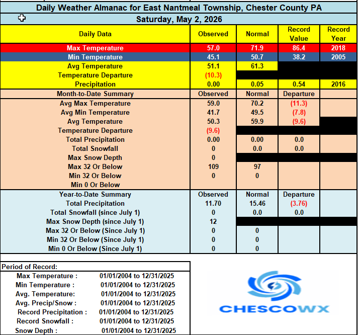
-
E PA/NJ/DE Spring 2026 Obs/Discussion
ChescoWx replied to PhiEaglesfan712's topic in Philadelphia Region
Another below normal temperature day on tap today before we see a brief warm up with some valley locations touching 80 degrees by Tuesday before we turn much chillier again by the end of the week. Highs by Thursday through Saturday may struggle to escape the upper 50's. Rain chances increase with a cold front by Tuesday night.
-
Welp I guess if our climate began in 1980 there could be a story there....
-
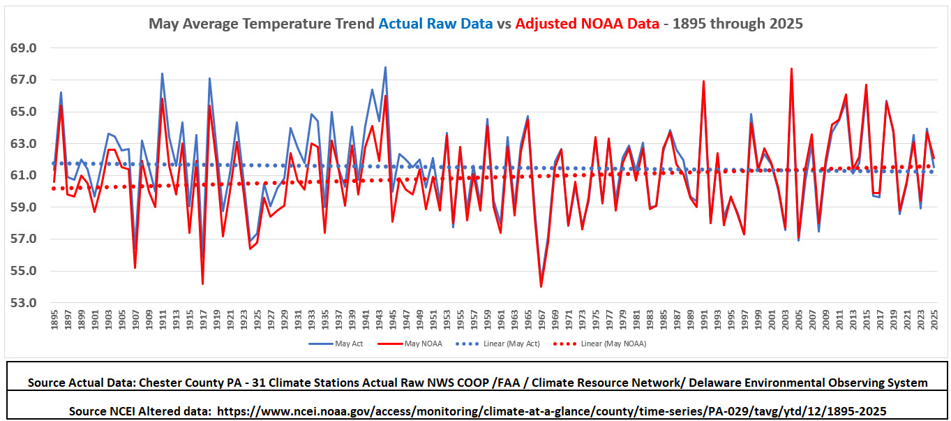
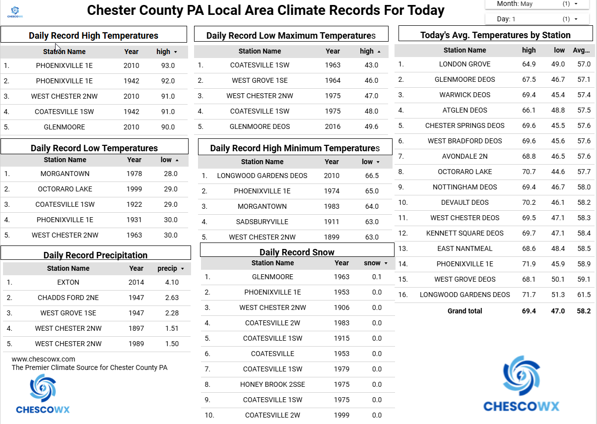
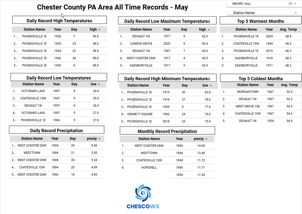
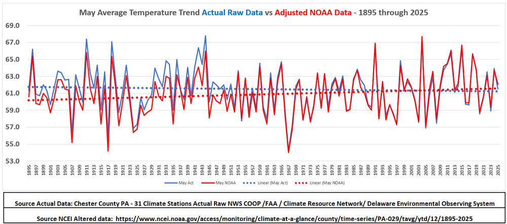
Below for the Philly burbs of Chester County PA are the all-time May climate records and below that the climate trends for the month. Based on the actual historical data (blue) our average May temperatures show a slight cooling trend since 1893 while the adjusted NCEI (red) temperatures indicate a very slight warming trendline.
-
LOL!! but it is the only 134 years of data we have for this beautiful county of Chester....so we analyze!!!
-
Central PA Spring 2026 Discussion/Obs Thread
ChescoWx replied to Voyager's topic in Upstate New York/Pennsylvania
Below for the Philly burbs of Chester County PA are the all-time May climate records and below that the climate trends for the month. Based on the actual historical data (blue) our average May temperatures show a slight cooling trend since 1893 while the adjusted NCEI (red) temperatures indicate a very slight warming trendline.
-
E PA/NJ/DE Spring 2026 Obs/Discussion
ChescoWx replied to PhiEaglesfan712's topic in Philadelphia Region
Below for the Philly burbs of Chester County PA are the all-time May climate records and below that the climate trends for the month. Based on the actual historical data (blue) our average May temperatures show a slight cooling trend since 1893 while the adjusted NCEI (red) temperatures indicate a very slight warming trendline.
-
Central PA Spring 2026 Discussion/Obs Thread
ChescoWx replied to Voyager's topic in Upstate New York/Pennsylvania
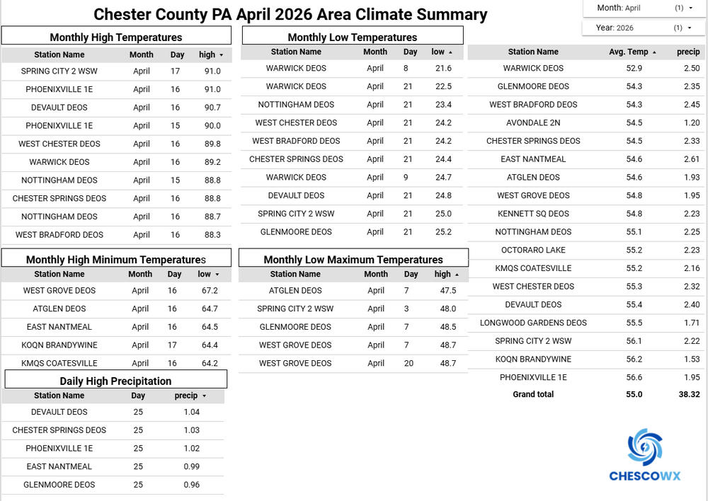
April finished as the 12th warmest (POR 133 years) first month of spring here in Chester County PA below are the Top 20 warm years. Our average of 55.0 was +2.8 degrees above our 1991-2020 climate normal of 52.2 degrees. January thru April 2026 is the 57th warmest first 4 months of a yea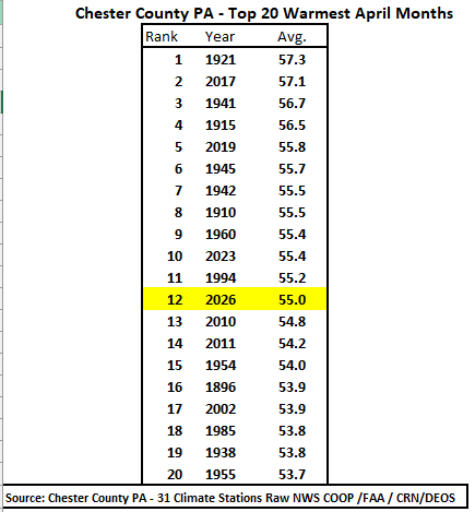
-
E PA/NJ/DE Spring 2026 Obs/Discussion
ChescoWx replied to PhiEaglesfan712's topic in Philadelphia Region
April finished as the 12th warmest (POR 133 years) first month of spring here in Chester County PA below are the Top 20 warm years. Our average of 55.0 was +2.8 degrees above our 1991-2020 climate normal of 52.2 degrees. January thru April 2026 is the 57th warmest first 4 months of a yea
-
I simply posed a question I did not say it was proof of anything...I unlike some understand when the n is way too short - LOL!!
-
Central PA Spring 2026 Discussion/Obs Thread
ChescoWx replied to Voyager's topic in Upstate New York/Pennsylvania
Today will be our 7th consecutive below normal temperature day with our temperatures remaining below normal through this weekend before we warm to above normal by Tuesday. We then turn cooler again for the rest of the first week of May. Overall, the long-range models see a chillier than normal month with some models continuing the relative chill into June. We have some slight shower chances tonight with rain chances increasing toward the middle of next week.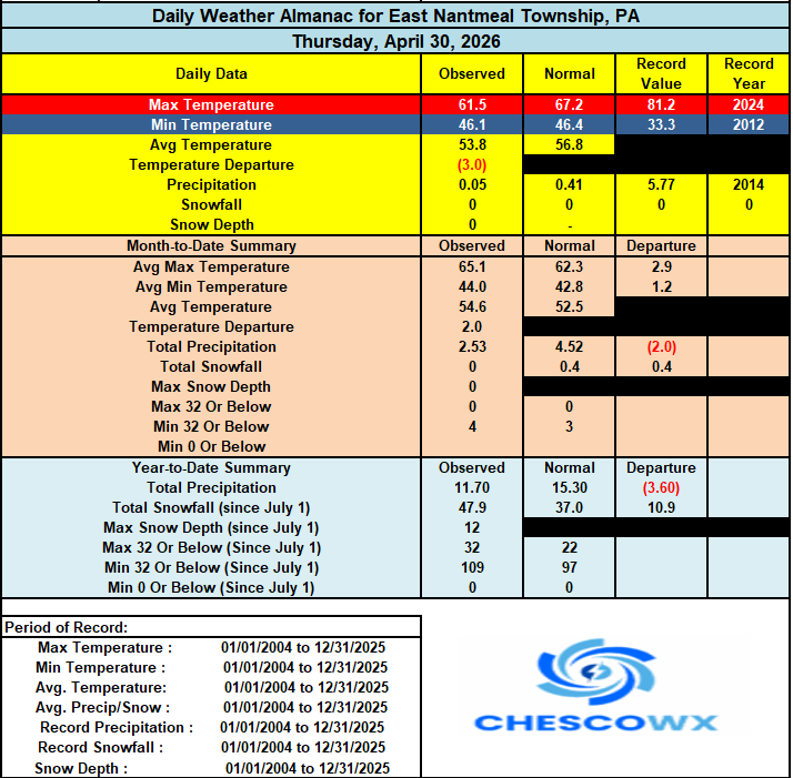

-
E PA/NJ/DE Spring 2026 Obs/Discussion
ChescoWx replied to PhiEaglesfan712's topic in Philadelphia Region
Today will be our 7th consecutive below normal temperature day with our temperatures remaining below normal through this weekend before we warm to above normal by Tuesday. We then turn cooler again for the rest of the first week of May. Overall, the long-range models see a chillier than normal month with some models continuing the relative chill into June. We have some slight shower chances tonight with rain chances increasing toward the middle of next week.
-
E PA/NJ/DE Spring 2026 Obs/Discussion
ChescoWx replied to PhiEaglesfan712's topic in Philadelphia Region
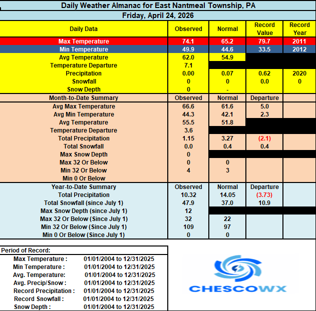
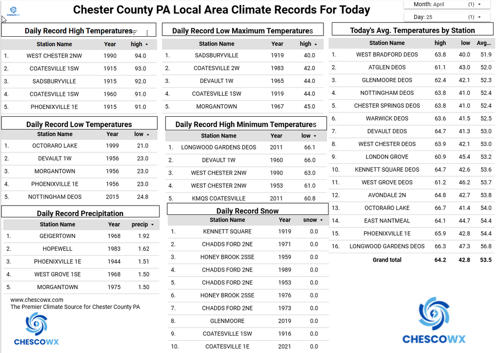
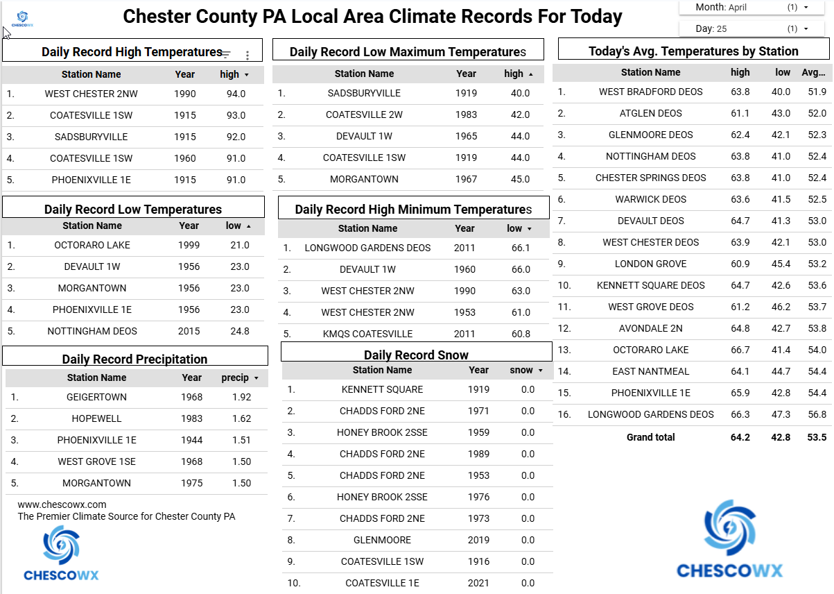
East Nantmeal finished with an April temperatures of 54.6 (+2.0 degrees above the 2003-2025 average) this is good for the 5th warmest April across 23 years of records. I am working up the overall Chester County climate records today and will share later. Overall with records back to 1893 we should come in close to a top 15 warmest April. -
E PA/NJ/DE Spring 2026 Obs/Discussion
ChescoWx replied to PhiEaglesfan712's topic in Philadelphia Region
Today was our 6th straight below normal temperature day and we picked up another 0.04" of rain this evening with the passing shower. -
Fortunately we have leadership and the people coming around to the climate grifts that have been taking place with folks like Al Gore...but c'mon chesco don't be a denier - there is clear scientific consensus - you know that 97% consensus story - LOL!!!!
-
LOL!!! OMG 131 years of history....what was the average temperature to the nearest 1c in Omaha NE in April 1779?? ridiculous cherry picking of small data history!
-
From our Administrator of the US EPA to congress "I'm also done with the likes of AOC, Al Gore, John Kerry, and the rest of the lying cabal that make stupid climate predictions, plunder tens of billions of tax dollars, enrich their well-connected allies, and are committed to strangulating out of existence entire sectors of our economy. Climate alarmist AOC wants to be taken seriously while also insisting the world is imminently about to end due to climate change (Just under 5 years remain on her nutty Jan 2019 prediction that only 12 years of life are left on Earth). Al Gore is now speaking publicly about his concern with global freezing after decades of grift talking about global warming. “Within the decade there will be no more snows of Kilimanjaro,” said Gore in 2006 (There’s still snow on Kilimanjaro year-round). Gore also predicted in 2009 ice-free Arctic summers within 5-7 years. John Kerry warned in 2009 that the Arctic would be ice-free by 2013. These people are dishonest, power-hungry hacks. The GREEN NEW SCAM is DEAD!!!
-
Central PA Spring 2026 Discussion/Obs Thread
ChescoWx replied to Voyager's topic in Upstate New York/Pennsylvania
Below normal temperatures are likely for the foreseeable future. We also turn wetter with rain chances increasing tomorrow morning and especially tomorrow night. Each day trends a bit chillier through the upcoming weekend with highs by Saturday around 15 degrees below normal for the start of May.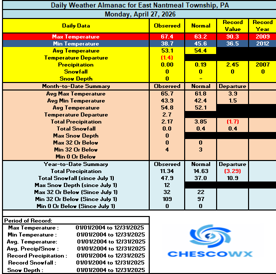
-
E PA/NJ/DE Spring 2026 Obs/Discussion
ChescoWx replied to PhiEaglesfan712's topic in Philadelphia Region
Makes sense! thanks Mike! -
E PA/NJ/DE Spring 2026 Obs/Discussion
ChescoWx replied to PhiEaglesfan712's topic in Philadelphia Region
Hi Mike - no doubt a silly question for you!! But in the AFD write up what determines unseasonably warm or unseasonably chilly? Is there a degree threshold above or below or subjective? Yesterday was in my view unseasonably chilly with temps around 10 degrees below normal values - yet in the AFD it said seasonably chilly. Thanks! Paul -
Central PA Spring 2026 Discussion/Obs Thread
ChescoWx replied to Voyager's topic in Upstate New York/Pennsylvania
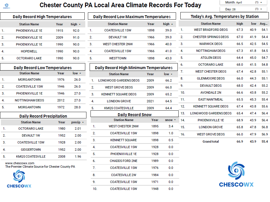
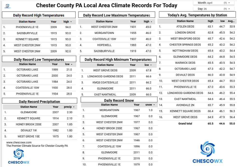
We received between 0.50” to 1.04” across the County with more falling across the north with that higher amount recorded at the Chester Springs DEOS station. We continue with unseasonably chilly weather today with highs remaining around the middle 50’s. Tonight, we could see some patchy frost and even a freeze in some of our typically colder valley locations We moderate to near normal in the mid 60’s both Monday and Tuesday before we turn chillier again and wetter by mid-week.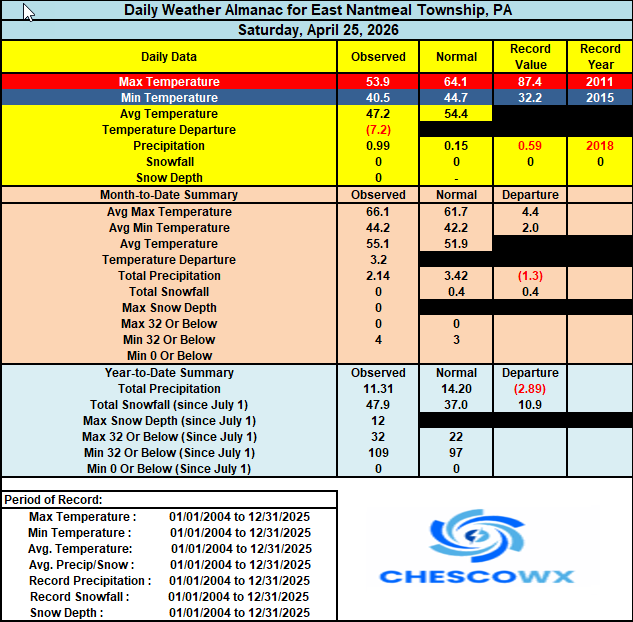
-
E PA/NJ/DE Spring 2026 Obs/Discussion
ChescoWx replied to PhiEaglesfan712's topic in Philadelphia Region
We received between 0.50” to 1.04” across the County with more falling across the north with that higher amount recorded at the Chester Springs DEOS station. We continue with unseasonably chilly weather today with highs remaining around the middle 50’s. Tonight, we could see some patchy frost and even a freeze in some of our typically colder valley locations We moderate to near normal in the mid 60’s both Monday and Tuesday before we turn chillier again and wetter by mid-week.
-
Central PA Spring 2026 Discussion/Obs Thread
ChescoWx replied to Voyager's topic in Upstate New York/Pennsylvania
Unseasonably chilly weather this weekend with high temperatures more than 10 degrees below normal for the end of April. We have picked up 0.04" of rain so far today here in East Nantmeal and it looks like as much as another inch could fall across the area by noon tomorrow. Temperatures this afternoon will likely fall into the 40's by evening and reach the upper 30's by morning. We warm back into the low 60's but still several degrees below normal for the rest of the work week with more rain chances by Tuesday night through Wednesday.