(002).png.f2cbd7c955dc3007a02ab79925b174ec.png)
ChescoWx
-
Posts
11,082 -
Joined
-
Last visited
Content Type
Profiles
Blogs
Forums
American Weather
Media Demo
Store
Gallery
Everything posted by ChescoWx
-
(002).thumb.png.6e3d9d46bca5fe41aab7a74871dd8af8.png)
Central PA Summer 2026 Discussion/Obs Thread
ChescoWx replied to Voyager's topic in Upstate New York/Pennsylvania
Many of our valley locations saw lows well down into the 50's with the coolest being the 53.6 at Warwick Township. We start the week with near normal temperatures and low humidity but by Thursday many spots will be in the low 90's with increasing humidity. We look to stay hot through the weekend, but it looks to be short lived with cooler temperatures arriving next week. Our best rain chance will be Wednesday afternoon into the evening.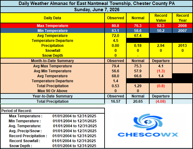
-
E PA/NJ/DE Spring 2026 Obs/Discussion
ChescoWx replied to PhiEaglesfan712's topic in Philadelphia Region
Many of our valley locations saw lows well down into the 50's with the coolest being the 53.6 at Warwick Township. We start the week with near normal temperatures and low humidity but by Thursday many spots will be in the low 90's with increasing humidity. We look to stay hot through the weekend, but it looks to be short lived with cooler temperatures arriving next week. Our best rain chance will be Wednesday afternoon into the evening.
-
Central PA Summer 2026 Discussion/Obs Thread
ChescoWx replied to Voyager's topic in Upstate New York/Pennsylvania
Temperatures similar to yesterday with highs in the low to mid 80's. We turn a couple of degrees cooler tomorrow. We then start a warming trend with some spots touching 90 degrees on both Thursday and Friday. There will be some chances at a shower by Thursday night.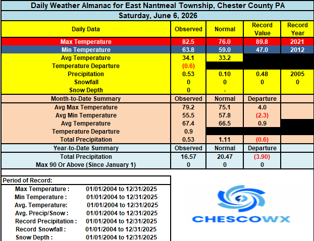
-
E PA/NJ/DE Spring 2026 Obs/Discussion
ChescoWx replied to PhiEaglesfan712's topic in Philadelphia Region
Temperatures similar to yesterday with highs in the low to mid 80's. We turn a couple of degrees cooler tomorrow. We then start a warming trend with some spots touching 90 degrees on both Thursday and Friday. There will be some chances at a shower by Thursday night.
-
Central PA Summer 2026 Discussion/Obs Thread
ChescoWx replied to Voyager's topic in Upstate New York/Pennsylvania
Today the PHL Airport looks to record a "heat wave" with their 3rd straight 90+ day. Here in Chesco most spots have not hit 90 degrees over the last few weeks, but we should see many spots do so today. There is a chance of some thunderstorms later this evening that would be welcomed as we continue to run dry across the region. A few degrees cooler tomorrow and several degrees cooler than that on Monday. We start another warming trend on Tuesday and could reach close to 90 degrees again by Thursday.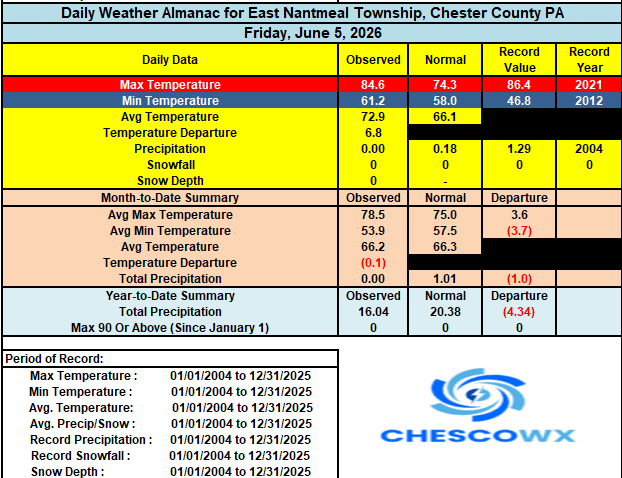
-
E PA/NJ/DE Spring 2026 Obs/Discussion
ChescoWx replied to PhiEaglesfan712's topic in Philadelphia Region
Today the PHL Airport looks to record a "heat wave" with their 3rd straight 90+ day. Here in Chesco most spots have not hit 90 degrees over the last few weeks, but we should see many spots do so today. There is a chance of some thunderstorms later this evening that would be welcomed as we continue to run dry across the region. A few degrees cooler tomorrow and several degrees cooler than that on Monday. We start another warming trend on Tuesday and could reach close to 90 degrees again by Thursday.
-
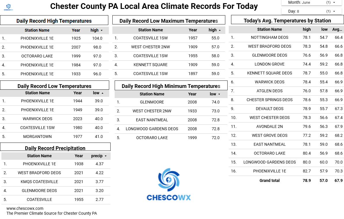
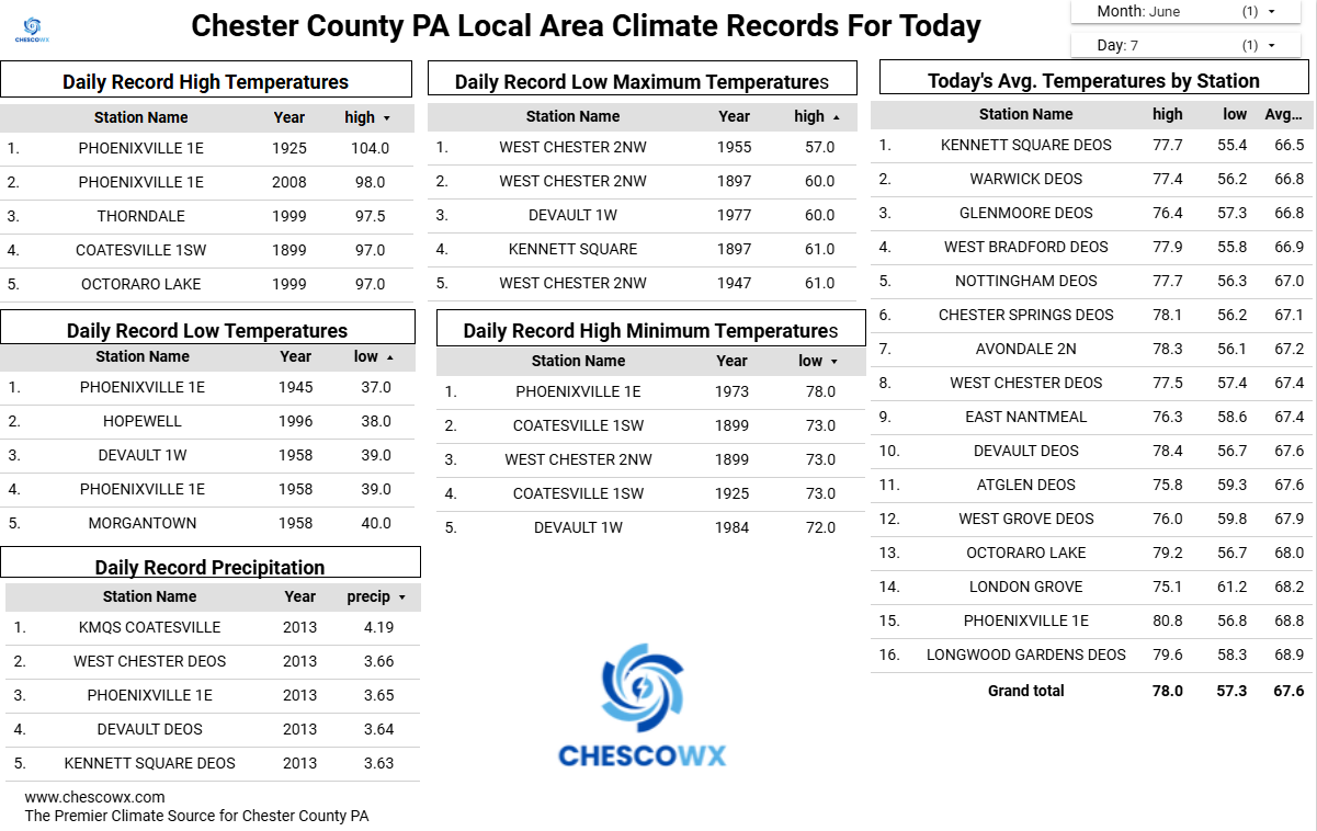
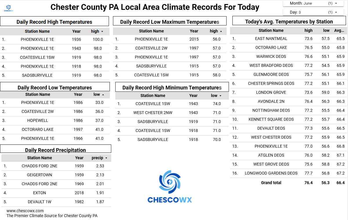
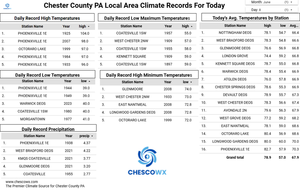
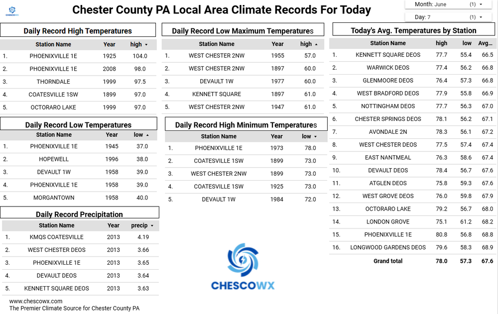
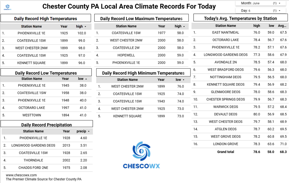
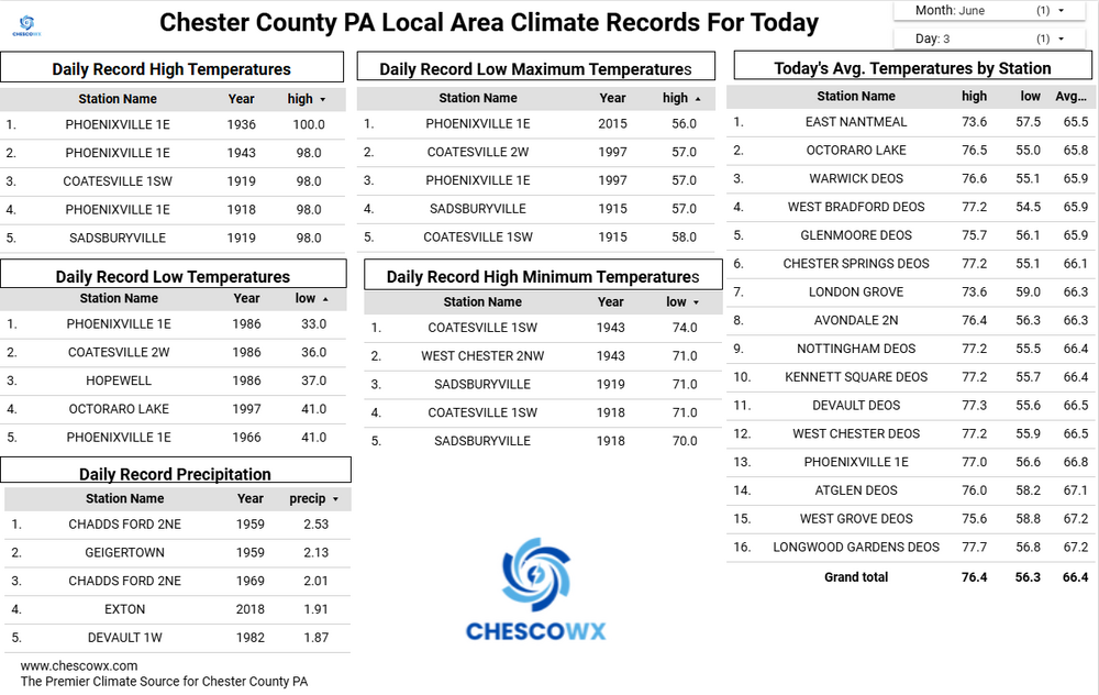
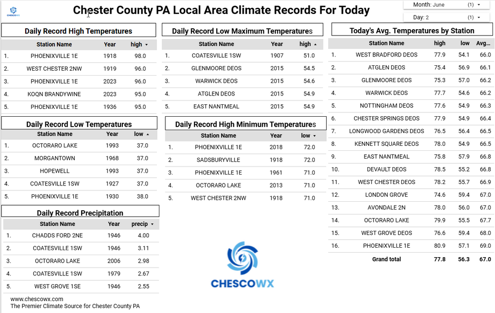
Below is the Chester County PA area daily climate records for June since 1893. Also below is the June warmest high temperatures by state. Of note 32 states set their June record highs before 1960 this is similar to here in Chester County where 26 of our 30 June daily record highs all occurred prior to 1960.

-
Central PA Summer 2026 Discussion/Obs Thread
ChescoWx replied to Voyager's topic in Upstate New York/Pennsylvania
Through May this has been our coldest start to a year since 2015. We should finally see some above normal temperatures starting tomorrow and peaking at around 90 degrees by Saturday. We then see some increasing chances of showers by Saturday night with temperatures cooling back to near normal levels by next Monday.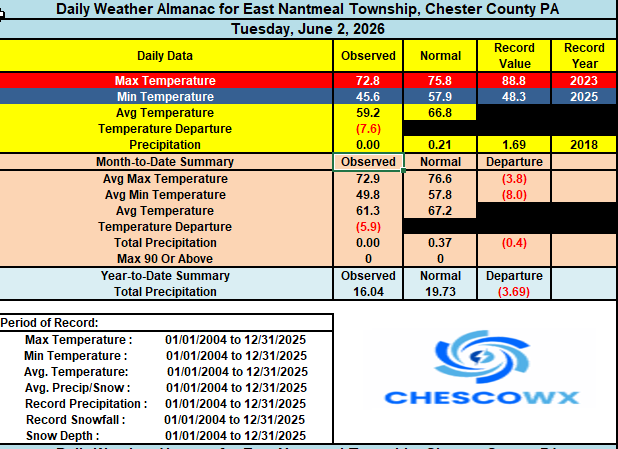
-
E PA/NJ/DE Spring 2026 Obs/Discussion
ChescoWx replied to PhiEaglesfan712's topic in Philadelphia Region
Through May this has been our coldest start to a year since 2015. We should finally see some above normal temperatures starting tomorrow and peaking at around 90 degrees by Saturday. We then see some increasing chances of showers by Saturday night with temperatures cooling back to near normal levels by next Monday.
-
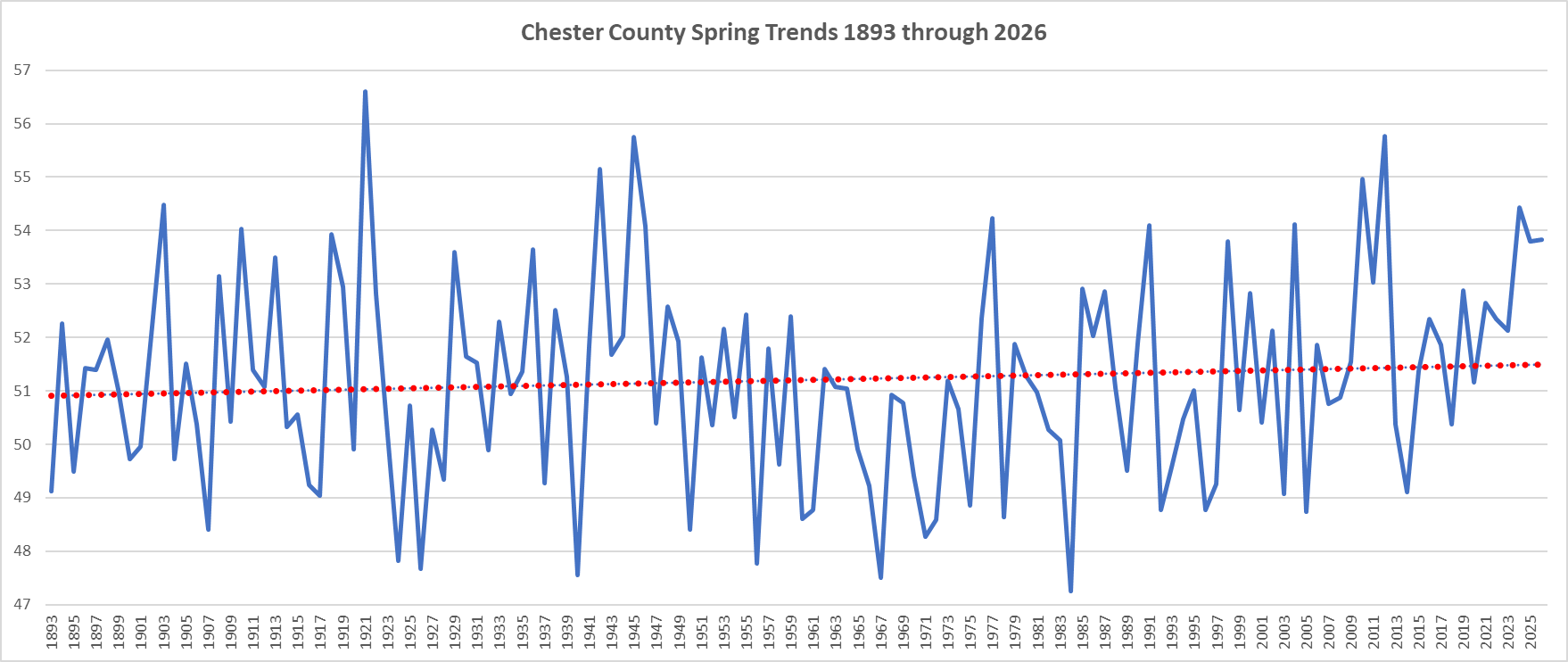
Of note Spring of 2026 was the 14th warmest Spring since 1893 - conversely Winter 2025-26 was our 14th coldest! Our weather does have a way of balancing out! Below is our Spring Temperature trends since 1893....only some slight warming evidenced by the data.

-
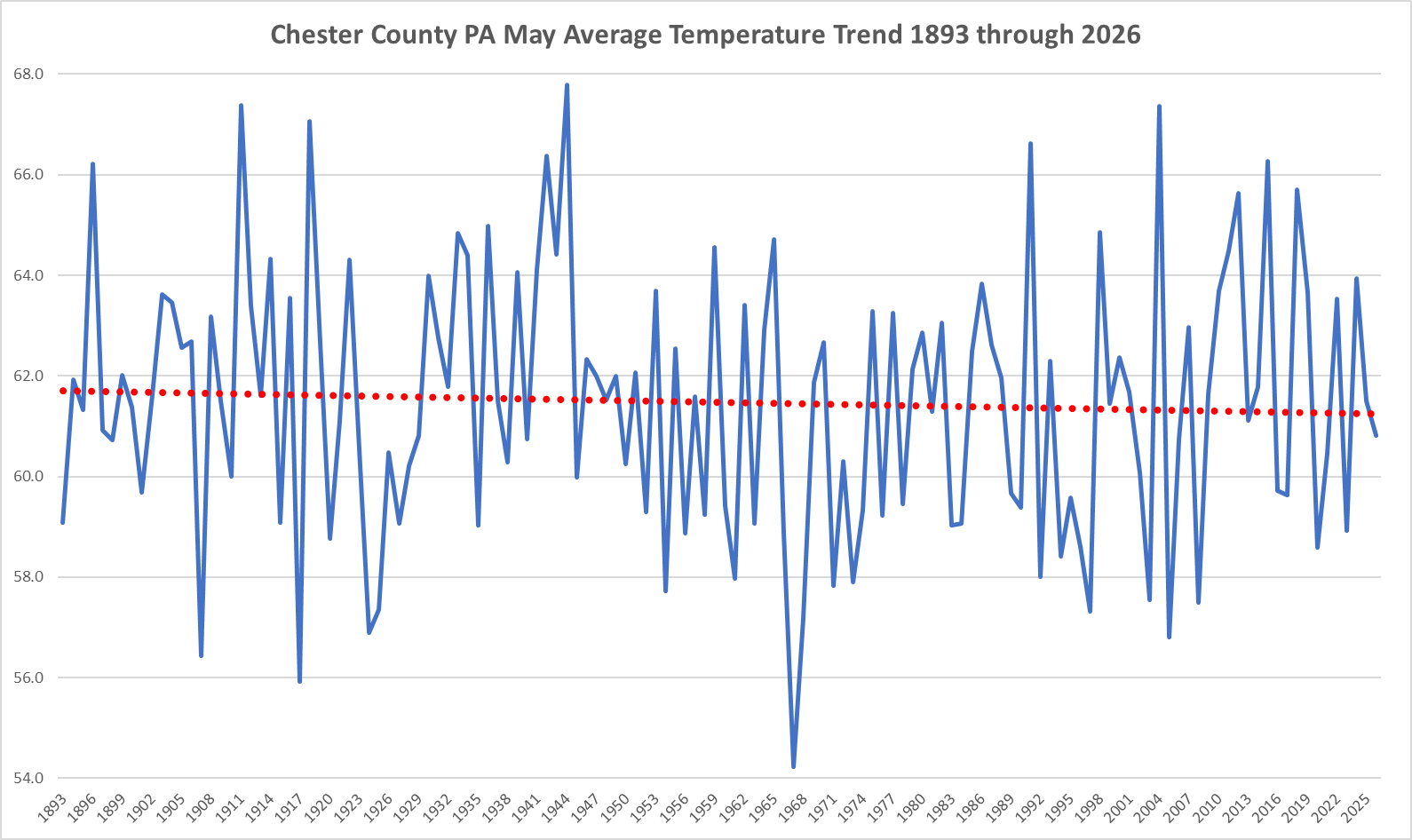
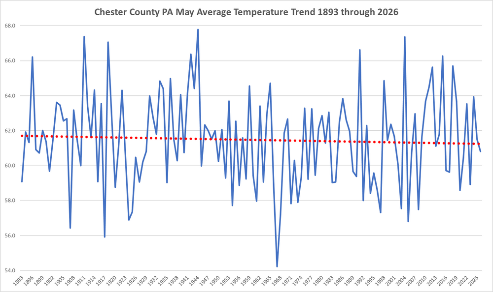
Since 1893 we have seen a cooling trend during the month of May here in Chester County PA
-
Central PA Summer 2026 Discussion/Obs Thread
ChescoWx replied to Voyager's topic in Upstate New York/Pennsylvania
Of note here in the philly burbs of Chester County PA Spring of 2026 was the 14th warmest Spring since 1893 - conversely Winter 2025-26 was our 14th coldest! Our weather does have a way of balancing out! Below is our Spring Temperature trends since 1893....only some slight warming is shown.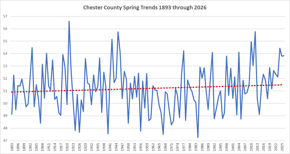
-
E PA/NJ/DE Spring 2026 Obs/Discussion
ChescoWx replied to PhiEaglesfan712's topic in Philadelphia Region
Of note here in the philly burbs of Chester County PA Spring of 2026 was the 14th warmest Spring since 1893 - conversely Winter 2025-26 was our 14th coldest! Our weather does have a way of balancing out! Below is our Spring Temperature trends since 1893....only some slight warming is shown.
-
Central PA Summer 2026 Discussion/Obs Thread
ChescoWx replied to Voyager's topic in Upstate New York/Pennsylvania
Since 1893 we have seen a cooling trend during the month of May
-
E PA/NJ/DE Spring 2026 Obs/Discussion
ChescoWx replied to PhiEaglesfan712's topic in Philadelphia Region
Since 1893 we have seen a cooling trend during the month of May
-
Central PA Summer 2026 Discussion/Obs Thread
ChescoWx replied to Voyager's topic in Upstate New York/Pennsylvania
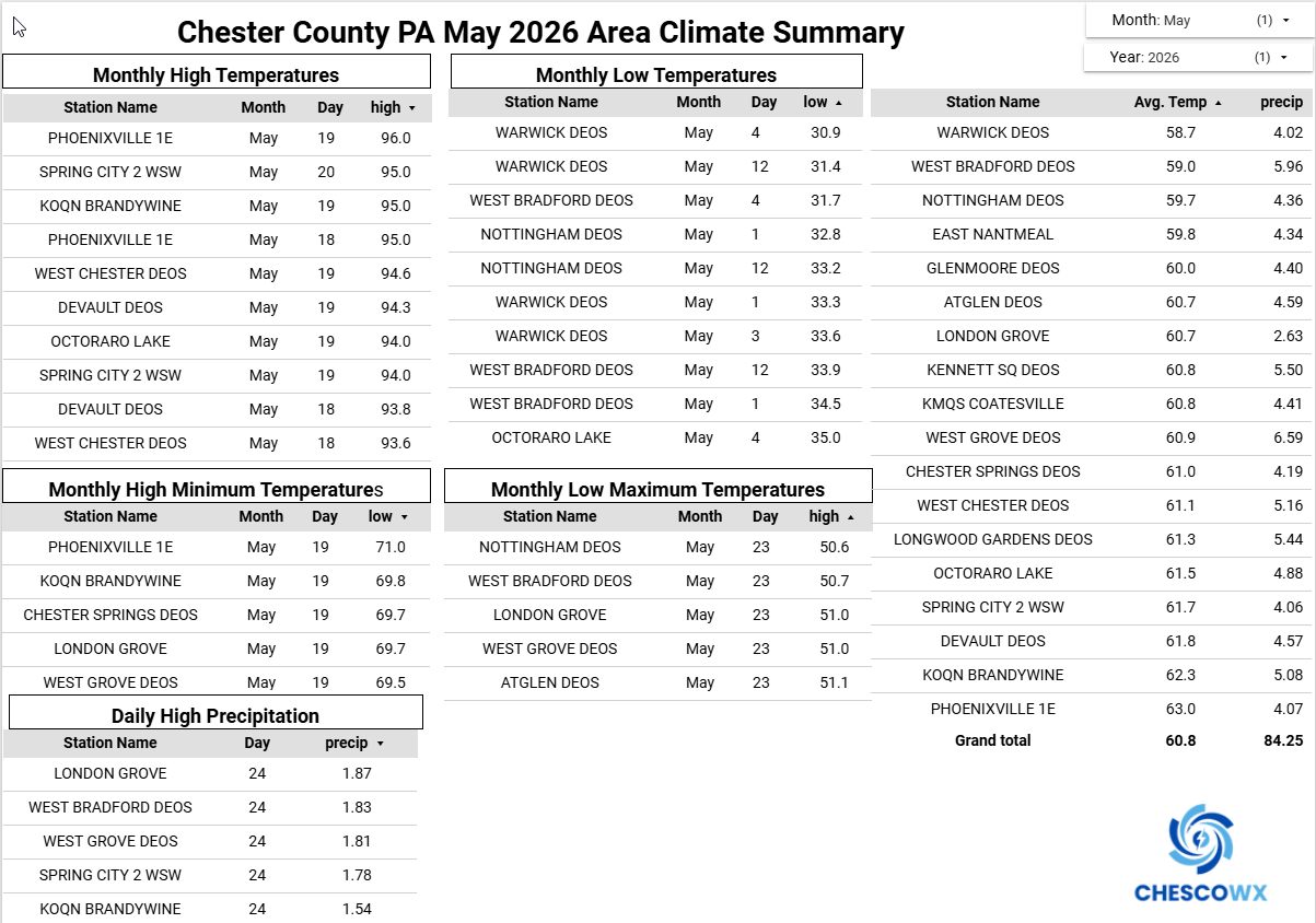
Below is the May 2026 Chester County Climate Summary. We finished May with an average temperature of 60.8 degrees across all stations. This was 0.7 degrees below the 1991-2020 average May temperature of 61.5 degrees. This was the 56th coldest May in 134 years of records back to 1893.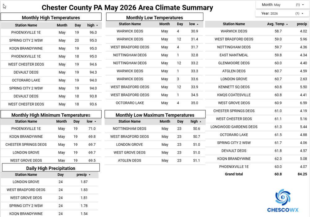
-
E PA/NJ/DE Spring 2026 Obs/Discussion
ChescoWx replied to PhiEaglesfan712's topic in Philadelphia Region
Below is the May 2026 Chester County Climate Summary. We finished May with an average temperature of 60.8 degrees across all stations. This was 0.7 degrees below the 1991-2020 average May temperature of 61.5 degrees. This was the 56th coldest May in 134 years of records back to 1893.
-
Central PA Summer 2026 Discussion/Obs Thread
ChescoWx replied to Voyager's topic in Upstate New York/Pennsylvania
Today will be the 11th of the last 13 days with below normal temperatures. Sunny and dry through Saturday. We should finally see some warmer than average temperatures by the end of the week and into the weekend. Rain chances look to increase by Sunday.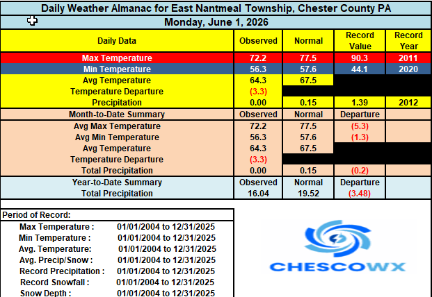
-
E PA/NJ/DE Spring 2026 Obs/Discussion
ChescoWx replied to PhiEaglesfan712's topic in Philadelphia Region
I am compiling the final averages but it looks like Chester County will finish around a 1 degree below the 1991-2020 average for the Month of May -
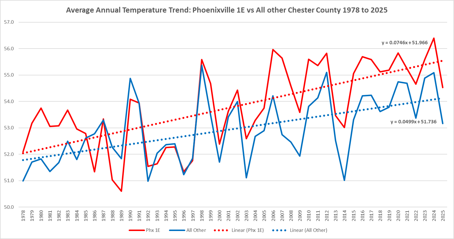
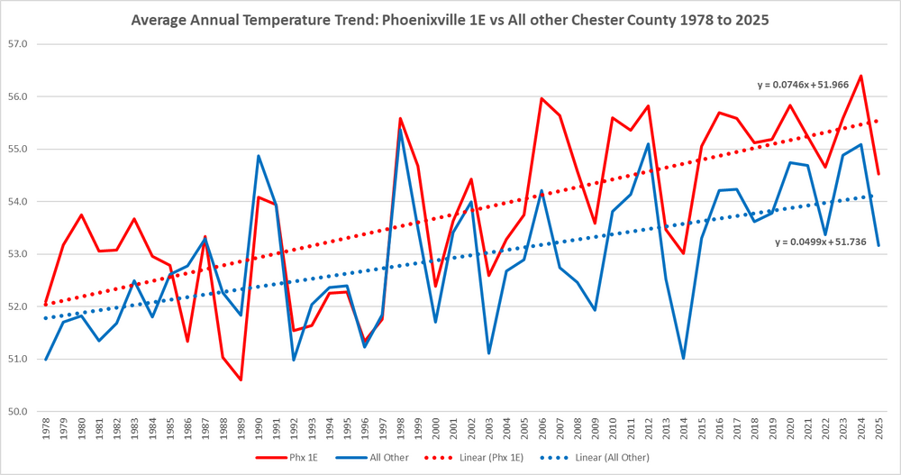
But of course during that 1978 to 2025 period Phoenixville 1E is warming at almost a 50% faster rate than the rest of Chester County. The Phoenixville area is about as least representative of the entire county with about 60% of Chesco lying at over 400ft above sea level
-
Central PA Spring 2026 Discussion/Obs Thread
ChescoWx replied to Voyager's topic in Upstate New York/Pennsylvania
Lows this morning were not too far from record cold levels for the final day of May. The lowest was the 38-degree reading at Warwick Township. During our last 37 days we have seen 26 of those days with below normal temperatures here in East Nantmeal. This pattern looks to it will continue through mid-week before we finally see temperatures warming to above normal by the end of the work week. Unfortunately there is no rain in site.
-
E PA/NJ/DE Spring 2026 Obs/Discussion
ChescoWx replied to PhiEaglesfan712's topic in Philadelphia Region
Lows this morning were not too far from record cold levels for the final day of May. The lowest was the 38-degree reading at Warwick Township. During our last 37 days we have seen 26 of those days with below normal temperatures here in East Nantmeal. This pattern looks to it will continue through mid-week before we finally see temperatures warming to above normal by the end of the work week. Unfortunately there is no rain in site.
-
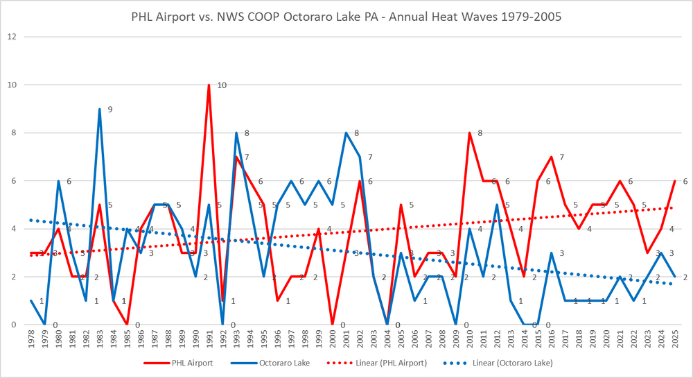
Maybe an even better example of the Urban Heat Island Problem at PHL Airport is to compare the airport to NWS COOP observations at Octoraro Lake on the SW border of Chester County at about 40 nautical miles due west of the airport. Octoraro Lake is a relative low elevation spot (260 ft asl) and that NWS COOP station is clearly seeing decreasing heat waves while PHL continues to have increasing "heat waves". The only material difference is rural vs UHI
-
Welp except for what you have stated before were the multiple moves from a relatively more urban locale to rural at Coatesville 1SW and of course the increase in elevation with the 1983 move to Coatesville 2W and then over to KMQS.......