-
Posts
7,506 -
Joined
-
Last visited
Content Type
Profiles
Blogs
Forums
American Weather
Media Demo
Store
Gallery
Everything posted by ChescoWx
-
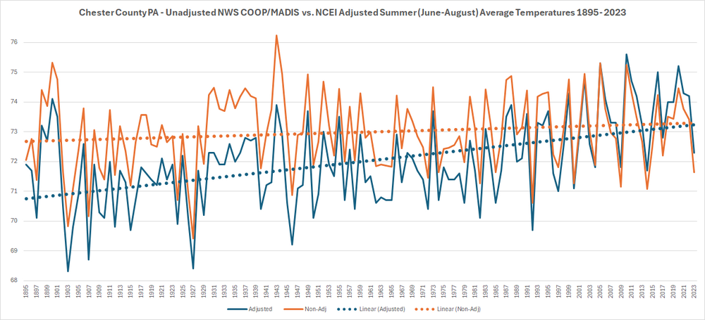
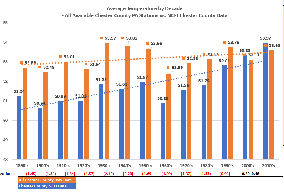
I have been working with the great folks at the Delaware Environmental Observing System (Thanks to Chris!!) to add even more weather observation points and stations across Chester County PA. With the updated data and summer coming I thought I would run an analysis of Summer (June-August) temperatures across the County from 1895 through last summer (now with 25 Chester County Stations at least partially in the data since 1895 and 15 current observation sites included). Overall in the non-adjusted data there is only as expected normal cyclical warm and cool cycles but I thought I would show you a comparison of the post observation adjustment applied by the the National Center of Environmental Information (NCEI) who have applied 111 consecutive years of post observation adjustments to chill the actual observations to each and every summer from 1895 through 2005 and have every year since 2005 now applied a warming adjustment. As you can see in the trend lines the orange non-adjusted and blue adjusted paint a far different rate of our rate of warming.
-

E PA/NJ/DE Spring 2024 OBS/Discussion
ChescoWx replied to Hurricane Agnes's topic in Philadelphia Region
I have been working with the great folks at the Delaware Environmental Observing System (Thanks to Chris!!) to add even more weather observation points and stations across Chester County PA. With the updated data and summer coming I thought I would run an analysis of Summer (June-August) temperatures across the County from 1895 through last summer (now with 25 Chester County Stations at least partially in the data since 1895 and 15 current observation sites included). Overall in the non-adjusted data there is only as expected normal cyclical warm and cool cycles but I thought I would show you a comparison of the post observation adjustment applied by the the National Center of Environmental Information (NCEI) who have applied 111 consecutive years of post observation adjustments to chill the actual observations to each and every summer from 1895 through 2005 and have every year since 2005 now applied a warming adjustment. As you can see in the trend lines the orange non-adjusted and blue adjusted paint a far different rate of our rate of warming. -
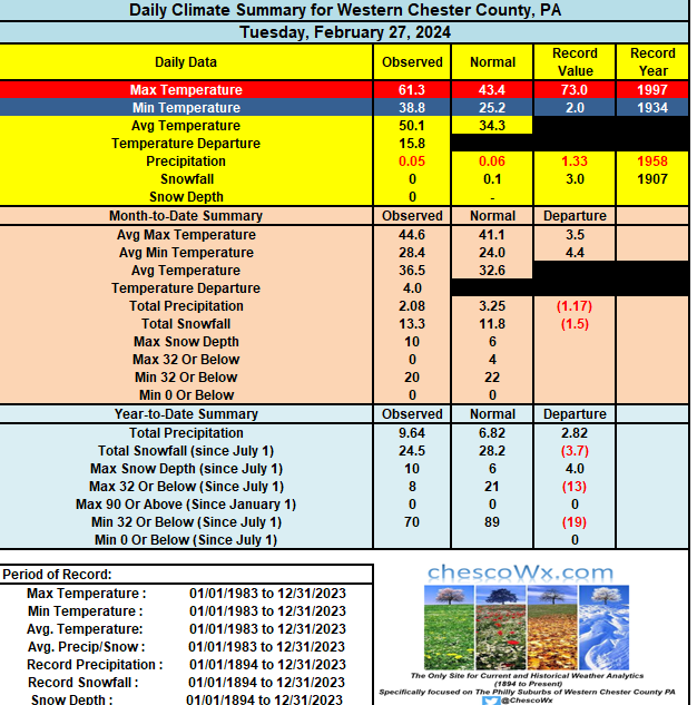
Beautiful stretch of weather starts today through Thursday. Temps rising into the low 60's today to upper 60's by Thursday. Next chance of showers Thursday night into Friday AM. Chester County records: High 84 West Chester (1990) / Low 1 above Phoenixville (1934) / Rain 1.68" West Grove (1936)/ Snow 4.3" East Nantmeal (2022)
-

E PA/NJ/DE Spring 2024 OBS/Discussion
ChescoWx replied to Hurricane Agnes's topic in Philadelphia Region
Beautiful stretch of weather starts today through Thursday. Temps rising into the low 60's today to upper 60's by Thursday. Next chance of showers Thursday night into Friday AM. Chester County records: High 84 West Chester (1990) / Low 1 above Phoenixville (1934) / Rain 1.68" West Grove (1936)/ Snow 4.3" East Nantmeal (2022) -
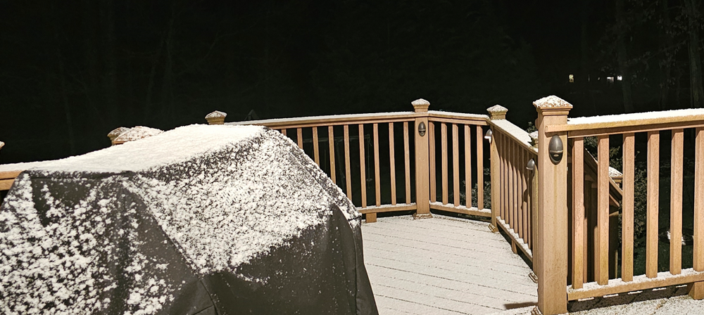
Along with our 0.3" of snow last evening was our first below freezing temperature since March 1st. Wind advisory remains in effect till 8pm tonight. Near normal temps today before a nice warming trend starts tomorrow. Some southern parts of Chesco could even touch 70 degrees by Thursday. Next week will be quite a bit cooler. County wide records for today: High 82 West Chester (2016) / Low 6 Phoenixville (1960) / Rain 2.60" Glenmoore (2011) / Snow 4.5" West Grove (1934)
-

E PA/NJ/DE Spring 2024 OBS/Discussion
ChescoWx replied to Hurricane Agnes's topic in Philadelphia Region
Along with our 0.3" of snow last evening was our first below freezing temperature since March 1st. Wind advisory remains in effect till 8pm tonight. Near normal temps today before a nice warming trend starts tomorrow. Some southern parts of Chesco could even touch 70 degrees by Thursday. Next week will be quite a bit cooler. County wide records for today: High 82 West Chester (2016) / Low 6 Phoenixville (1960) / Rain 2.60" Glenmoore (2011) / Snow 4.5" West Grove (1934) -

E PA/NJ/DE Spring 2024 OBS/Discussion
ChescoWx replied to Hurricane Agnes's topic in Philadelphia Region
-
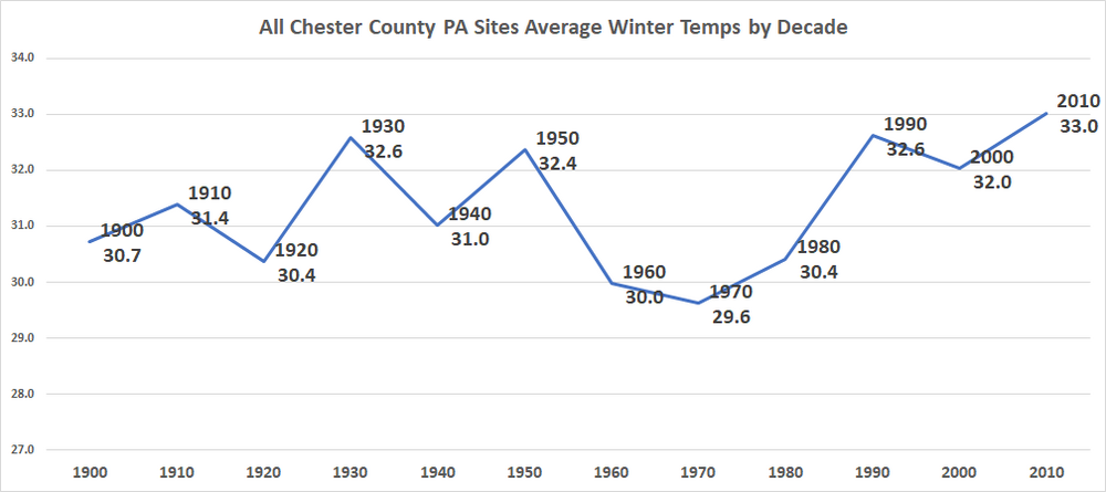
Below by decade are complete winter (Dec-Jan-Feb) average raw non-NCEI adjusted temperatures for all available Chester County PA Stations (22 total stations since 1900) as expected very cyclical in nature with the warmest decades being the 1930's / 1950's / 1990's and 2010's
-

Philadelphia Historical Snowfall Data:
ChescoWx replied to ncforecaster89's topic in Philadelphia Region
-
The first 7 days of March have been the warmest start to March in 20 years (2004). The warmest start in March history across all available Chester County sites was 50 years ago back in 1974. We look to turn chillier with closer to normal temps over the weekend with temps remaining in the 40's with rain tomorrow into Saturday night. We warm again during the next week before a pattern change to colder than normal starting toward the end of next week. Chester County wide records for today: High 80 degrees at Glenmoore / Honey Brook and Coatesville (2000) / Low zero West Chester (2007) / Rain 2.96" Coatesville (1995) / Snow 10.7" Phoenixville (1941)
-

E PA/NJ/DE Spring 2024 OBS/Discussion
ChescoWx replied to Hurricane Agnes's topic in Philadelphia Region
The first 7 days of March have been the warmest start to March in 20 years (2004). The warmest start in March history across all available Chester County sites was 50 years ago back in 1974. We look to turn chillier with closer to normal temps over the weekend with temps remaining in the 40's with rain tomorrow into Saturday night. We warm again during the next week before a pattern change to colder than normal starting toward the end of next week. Chester County wide records for today: High 80 degrees at Glenmoore / Honey Brook and Coatesville (2000) / Low zero West Chester (2007) / Rain 2.96" Coatesville (1995) / Snow 10.7" Phoenixville (1941) -
We continue our wet year as over the last 2 days rain totals ranged from a low of 0.68" at Glenmoore to as much as 1.00" in West Chester. We can a break with some sun and continued mild both today and tomorrow before rain arrives again Saturday. By Sunday morning we could see close to another inch of rain. County wide records for today: High 75 Coatesville (1921) / Low 4 below West Chester (2015) / Rain 2.70" West Grove (1967) / Snow 13.0" West Grove (1962)
-

E PA/NJ/DE Spring 2024 OBS/Discussion
ChescoWx replied to Hurricane Agnes's topic in Philadelphia Region
We continue our wet year as over the last 2 days rain totals ranged from a low of 0.68" at Glenmoore to as much as 1.00" in West Chester. We can a break with some sun and continued mild both today and tomorrow before rain arrives again Saturday. By Sunday morning we could see close to another inch of rain. County wide records for today: High 75 Coatesville (1921) / Low 4 below West Chester (2015) / Rain 2.70" West Grove (1967) / Snow 13.0" West Grove (1962) -
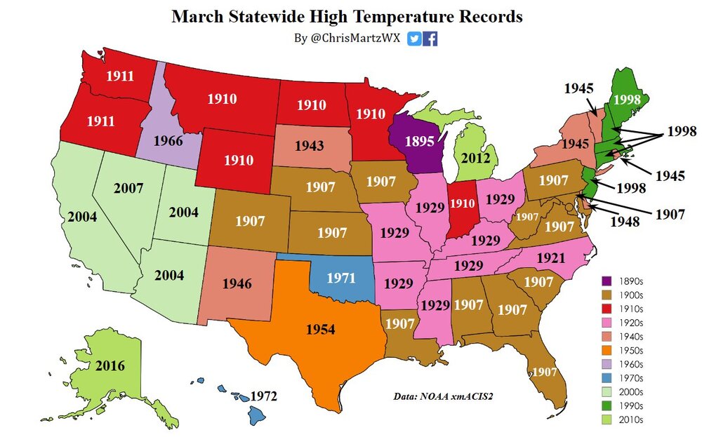
Below is a great list (Thanks Chris Martz) of all-time US by State high temperature records (of course before adjustments NOAA adjustments etc.). Per Chris "35 states set their “all-time” March monthly record high temperatures prior to 1955. Thirteen states set theirs in 1907 alone, the most in a single year and a single decade. Eight states set their March records in the 1920s, seven of which were in 1929. I ran the numbers by hand from NOAA's database on xmACIS2 and have been consulting with just about every state climatologist to confirm that these are in fact legitimate, as NOAA NCEI only lists records set for all months, not individual months."
-
0.83" of rain so far here in East Nantmeal. Some other area totals Atgen 0.72" /Warwick 0.75" / Chester Springs 0.82" / Glenmoore 0.84"/ Kennett Square 0.96" / West Bradford 0.93" / West Chester 0.93". Rain should continue through much of today with another 0.50" to 0.75" possible. Sun returns tomorrow and temps should get close to 60 degrees. County wide records for today: High 76 degrees Phoenixville (1972) / Low 1 above Phoenixville (1967) / Rain 1.65" West Grove (1954) / Snow 12.0" Devault (1969)
-

E PA/NJ/DE Spring 2024 OBS/Discussion
ChescoWx replied to Hurricane Agnes's topic in Philadelphia Region
0.83" of rain so far here in East Nantmeal. Some other area totals Atgen 0.72" /Warwick 0.75" / Chester Springs 0.82" / Glenmoore 0.84"/ Kennett Square 0.96" / West Bradford 0.93" / West Chester 0.93". Rain should continue through much of today with another 0.50" to 0.75" possible. Sun returns tomorrow and temps should get close to 60 degrees. County wide records for today: High 76 degrees Phoenixville (1972) / Low 1 above Phoenixville (1967) / Rain 1.65" West Grove (1954) / Snow 12.0" Devault (1969) -
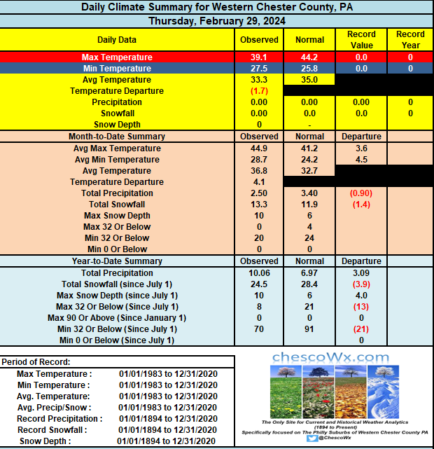
So across all available Chester County stations February ended with an average temp of 37.0 degrees - ranging from 35.9 at Warwick to 37.7 at Kennett Square. This is the 11th warmest overall County wide February on record. The top 5 warmest were: 2017 (40.8 /1998 (40.1) / 1990 (39.6) / 1909 (39.5) and 1954 (39.5)
-

E PA/NJ/DE Spring 2024 OBS/Discussion
ChescoWx replied to Hurricane Agnes's topic in Philadelphia Region
So across all available Chester County stations February ended with an average temp of 37.0 degrees - ranging from 35.9 at Warwick to 37.7 at Kennett Square. This is the 11th warmest overall County wide February on record. The top 5 warmest were: 2017 (40.8 /1998 (40.1) / 1990 (39.6) / 1909 (39.5) and 1954 (39.5) -
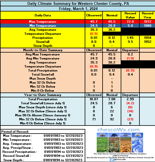
We saw subfreezing lows to start the day across Chesco this AM....but that should be the last below freezing day for at least the next week. A beautiful day today with high temps right about where they should be for March 1st in the mid-40's. Rain arrives toward midnight tonight and should last much of the day tomorrow with at least a half-inch of rain across most spots. The sun returns Sunday with highs well up into the 50's to near 60 degrees. County wide records for today: High 75 Chadds Ford (1972) / Low 1 above Phoenixville (1934) / Rain 1.45" Coatesville (1954) / Snow 11.0" Phoenixville (1952)
-

E PA/NJ/DE Spring 2024 OBS/Discussion
ChescoWx replied to Hurricane Agnes's topic in Philadelphia Region
We saw subfreezing lows to start the day across Chesco this AM....but that should be the last below freezing day for at least the next week. A beautiful day today with high temps right about where they should be for March 1st in the mid-40's. Rain arrives toward midnight tonight and should last much of the day tomorrow with at least a half-inch of rain across most spots. The sun returns Sunday with highs well up into the 50's to near 60 degrees. County wide records for today: High 75 Chadds Ford (1972) / Low 1 above Phoenixville (1934) / Rain 1.45" Coatesville (1954) / Snow 11.0" Phoenixville (1952) -
Today we end the winter months of December, January and February. While this year has been very warm it is actually almost a degree cooler than last winter. The warmest winter ever was way back in 1931/32 with an average temp of 39.51 degrees. Of note in our current warm cycle we have recorded 7 of the top 10 warmest DJF periods all just since the year 2000!!!
-

E PA/NJ/DE Winter 2023-2024 OBS/Discussion
ChescoWx replied to The Iceman's topic in Philadelphia Region
Today we end the winter months of December, January and February. While this year has been very warm it is actually almost a degree cooler than last winter. The warmest winter ever was way back in 1931/32 with an average temp of 39.51 degrees. Of note in our current warm cycle we have recorded 7 of the top 10 warmest DJF periods all just since the year 2000!!! -
0.15" of rain since yesterday so far here in East Nantmeal. We should see a couple rounds of heavy rain today. The first around the lunchtime hour and the 2nd with the cold frontal passage toward the 7pm hour. Some spots could see over 1/2 inch of rain today. Temps will again soar to near 60 degrees before the front passes. Behind the front winds will increase to near 40mph and temps will plunge from near 60 degrees at around 7pm to near freezing by 11pm. Tomorrow we will stay in the below normal 30's before our next warm up gets underway on Friday. County wide records for today: High 73 Devault and Phoenixville (1997) / Low 16 below Phoenixville (1934) / Rain 1.82" Coatesville (1902) / Snow 7.5" Coatesville (2005)
-

E PA/NJ/DE Winter 2023-2024 OBS/Discussion
ChescoWx replied to The Iceman's topic in Philadelphia Region
0.15" of rain since yesterday so far here in East Nantmeal. We should see a couple rounds of heavy rain today. The first around the lunchtime hour and the 2nd with the cold frontal passage toward the 7pm hour. Some spots could see over 1/2 inch of rain today. Temps will again soar to near 60 degrees before the front passes. Behind the front winds will increase to near 40mph and temps will plunge from near 60 degrees at around 7pm to near freezing by 11pm. Tomorrow we will stay in the below normal 30's before our next warm up gets underway on Friday. County wide records for today: High 73 Devault and Phoenixville (1997) / Low 16 below Phoenixville (1934) / Rain 1.82" Coatesville (1902) / Snow 7.5" Coatesville (2005) -

E PA/NJ/DE Winter 2023-2024 OBS/Discussion
ChescoWx replied to The Iceman's topic in Philadelphia Region
Nah nothing remotely sobering at all! Well only if you adjust the 1920's thru 1960's like our friends at NOAA/NCEI did for example here (see below) in Chester County PA - those nifty post adjustment fixes make quite the difference in that blue scary (sobering) line!!

