

CoastalWx
-
Posts
177,341 -
Joined
-
Last visited
Content Type
Profiles
Blogs
Forums
American Weather
Media Demo
Store
Gallery
Everything posted by CoastalWx
-
Significant upper middle Atlantic S/CNE mix/snow potential Jan 3+
CoastalWx replied to Typhoon Tip's topic in New England
I don't see how that indicates "Unhappy" and not seen as a joke. We all say that about his area. Don't forget the front is 1200' but the backyard is 1100'. -
Significant upper middle Atlantic S/CNE mix/snow potential Jan 3+
CoastalWx replied to Typhoon Tip's topic in New England
We're all so happy for him. -
Significant upper middle Atlantic S/CNE mix/snow potential Jan 3+
CoastalWx replied to Typhoon Tip's topic in New England
Might be in a better spot there? I wouldn’t lose sleep over it lol. There is a decent erly fetch at 700 which can sometimes surprise. -
Significant upper middle Atlantic S/CNE mix/snow potential Jan 3+
CoastalWx replied to Typhoon Tip's topic in New England
That was the same day! Even for the NAM that is bad. -
Hubbdave Mehing his way into the top of the weenie food chain.
-
The SSW is more like a displacement. It is legit, but I'm not sure how it will effect the troposphere.
-
I definitely wouldn't rule something out prior, just the overall look. It's quite possible something sneaks in before 1/15. I think for me personally, I look forward to after the 12-15th or so.
-
Significant upper middle Atlantic S/CNE mix/snow potential Jan 3+
CoastalWx replied to Typhoon Tip's topic in New England
76 pages lol. Oye. -
Significant upper middle Atlantic S/CNE mix/snow potential Jan 3+
CoastalWx replied to Typhoon Tip's topic in New England
Might be some -SN (maybe an inch or so) inside 495 near coast tonight into tomorrow morning. -
Significant upper middle Atlantic S/CNE mix/snow potential Jan 3+
CoastalWx replied to Typhoon Tip's topic in New England
One of the worst model fails I have ever seen. Up there with the NAM back in mid Feb 2014 when it had like 12-18" for me on the 18z run and I got 6". -
Significant upper middle Atlantic S/CNE mix/snow potential Jan 3+
CoastalWx replied to Typhoon Tip's topic in New England
Must have been a Stein Slot. Bone dry and 32. -
Seems like I should have stuck to my gut and said second half of Jan. Anything before is gravy.
-
Significant upper middle Atlantic S/CNE mix/snow potential Jan 3+
CoastalWx replied to Typhoon Tip's topic in New England
I hope Taunton is a field Of Joshua Trees by August. -
Significant upper middle Atlantic S/CNE mix/snow potential Jan 3+
CoastalWx replied to Typhoon Tip's topic in New England
This week was garbage anyways. It doesn’t mean next few days won’t suck weather wise. I enjoy the sunny days. The true melts of online insults and domestics won’t be here. -
Significant upper middle Atlantic S/CNE mix/snow potential Jan 3+
CoastalWx replied to Typhoon Tip's topic in New England
If that’s appealing, I feel bad. -
Significant upper middle Atlantic S/CNE mix/snow potential Jan 3+
CoastalWx replied to Typhoon Tip's topic in New England
Boy clouds and 38F will be epic for the next 3-4 days. Can’t wait. -
Significant upper middle Atlantic S/CNE mix/snow potential Jan 3+
CoastalWx replied to Typhoon Tip's topic in New England
Enjoy the rain. -
Significant upper middle Atlantic S/CNE mix/snow potential Jan 3+
CoastalWx replied to Typhoon Tip's topic in New England
Looks like RA/SN like over Braintree/Quincy border. About 2.5 miles NW.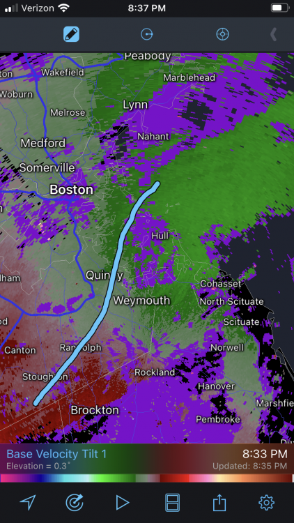
-
Significant upper middle Atlantic S/CNE mix/snow potential Jan 3+
CoastalWx replied to Typhoon Tip's topic in New England
Guidance pretty good with that. Blah. -
Significant upper middle Atlantic S/CNE mix/snow potential Jan 3+
CoastalWx replied to Typhoon Tip's topic in New England
Remember when the euro had a month’s worth of QPF on the cape at 18z yesterday? Fail of all fails. Pretty sure it ****ed Nova Scotia too. -
Significant upper middle Atlantic S/CNE mix/snow potential Jan 3+
CoastalWx replied to Typhoon Tip's topic in New England
Nah not convective like that. I don’t mean banded, it’s literally cellular. -
Significant upper middle Atlantic S/CNE mix/snow potential Jan 3+
CoastalWx replied to Typhoon Tip's topic in New England
Might grab a local 1-2 there. -
Significant upper middle Atlantic S/CNE mix/snow potential Jan 3+
CoastalWx replied to Typhoon Tip's topic in New England
I honestly don’t think I’ve ever seen a radar so shredded like this. It’s not meant to poo poo or anything like that. From a met standpoint, that’s hard to do. Usually you have a solid band of rather moderate or greater echoes. -
Significant upper middle Atlantic S/CNE mix/snow potential Jan 3+
CoastalWx replied to Typhoon Tip's topic in New England
Nothing? Just noting. -
Significant upper middle Atlantic S/CNE mix/snow potential Jan 3+
CoastalWx replied to Typhoon Tip's topic in New England
?? Radar is atrocious. Compare the radar with any other pedestrian event and it’s night and day even from that. You aren’t supposed to have no echoes near to 30DBZ echoes.


