RitualOfTheTrout
-
Posts
3,691 -
Joined
-
Last visited
Content Type
Profiles
Blogs
Forums
American Weather
Media Demo
Store
Gallery
Everything posted by RitualOfTheTrout
-

Western PA/Pittsburgh Summer Discussion 2021
RitualOfTheTrout replied to Ahoff's topic in Upstate New York/Pennsylvania
Latest trends do seem to have shifted SE with the track and expanse of the heaviest rain. That map looks like so many Winter Storms over the past several years it almost triggers some PTSD lol. Only this time I’ll be fine getting fringed, 1-2 inches will be much more manageable and another tick SE puts most of the city out of significant impact. -
Western PA/Pittsburgh Summer Discussion 2021
RitualOfTheTrout replied to Ahoff's topic in Upstate New York/Pennsylvania
Yeah it's hard to say what to "root" for on this in terms of mitigating impacts. Hopefully some of those rain amounts are overdone at this range. 4-5 inches in an 18-24 hour period will no doubt cause some problems.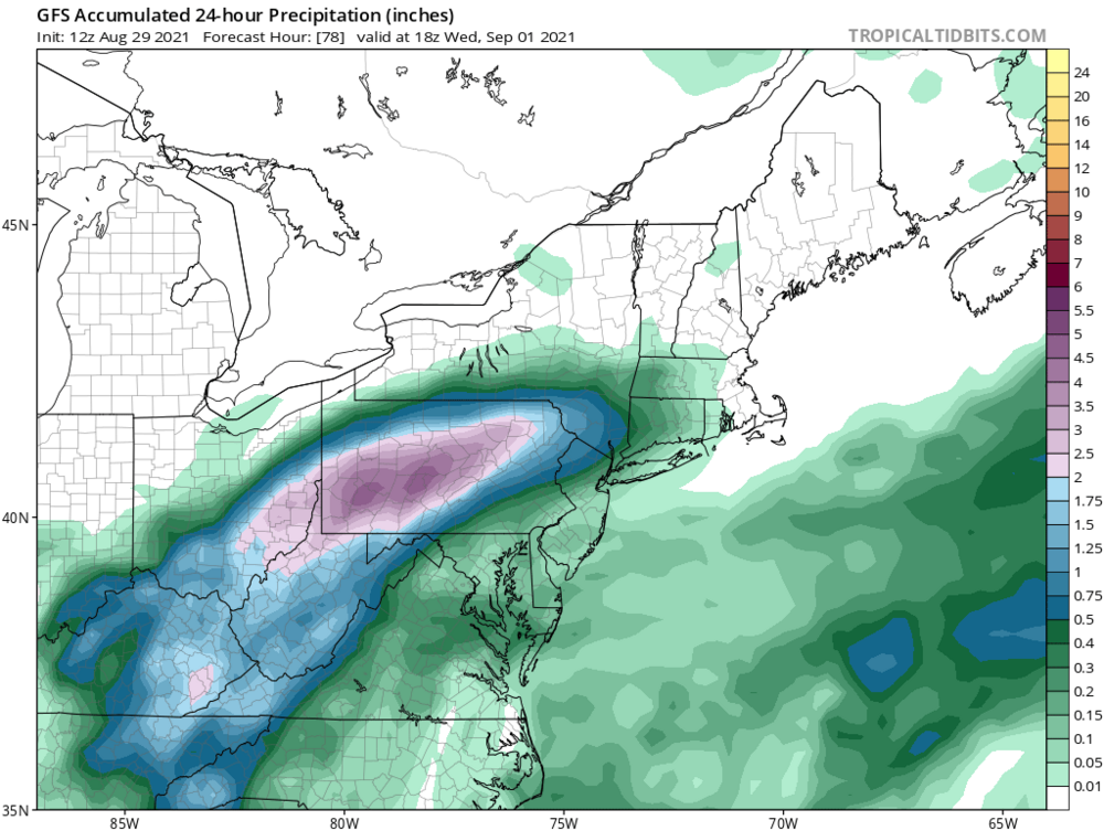
-
Western PA/Pittsburgh Summer Discussion 2021
RitualOfTheTrout replied to Ahoff's topic in Upstate New York/Pennsylvania
Interesting watching the radar this morning. Not often you can see a clearly defined center of circulation from a tropical storm / remnants moving right towards us. -
Western PA/Pittsburgh Summer Discussion 2021
RitualOfTheTrout replied to Ahoff's topic in Upstate New York/Pennsylvania
Yeah, I'm ready for this pattern to break for a long dry spell. Pool needs drained every other day and my backyard fill project on hold because it's just so muddy. One good thing I guess, the garden is going crazy. -
Western PA/Pittsburgh Summer Discussion 2021
RitualOfTheTrout replied to Ahoff's topic in Upstate New York/Pennsylvania
At work, but I heard 3 rumbles of Thunder! wohoo -
Western PA/Pittsburgh Spring Discussion 2021
RitualOfTheTrout replied to Ahoff's topic in Upstate New York/Pennsylvania
That's interesting, I hadn't checked the records / realized May 9th had that many cold records. -
Western PA/Pittsburgh Spring Discussion 2021
RitualOfTheTrout replied to Ahoff's topic in Upstate New York/Pennsylvania
I just hope when this pattern ends we don't shoot right into mid 80s and humidity. Average May weather is pretty enjoyable so it does suck to be so cool right now. On the other hand, it wouldn't have taken much to be slightly colder to break some May snowfall records today. If it's going to be 40 and rain may as well be 35 and snow in my opinion and make it interesting. -
Western PA/Pittsburgh Spring Discussion 2021
RitualOfTheTrout replied to Ahoff's topic in Upstate New York/Pennsylvania
Just sprinkles so far imby today. Think I've only heard thunder once this Spring which is unusual. -
Western PA/Pittsburgh Spring Discussion 2021
RitualOfTheTrout replied to Ahoff's topic in Upstate New York/Pennsylvania
Yeah that was a heck of a night here... Phones went off with the warning and woke us up, my wife was like should we be worried, I looked outside and saw the rain going horizontal as the radar loaded on my phone and yelled yes get the kids and let's get in the basement. We could hear patio furniture sliding across the deck. We were without power for a solid 12 hours afterwards. Luckily no damage other than a destroyed trampoline. I remember being glad I had a dying 80 ft locust tree near the house cut down 2 weeks earlier. Wouldn't mind some thunderstorms either but can do without the tornado. -
Western PA/Pittsburgh Spring Discussion 2021
RitualOfTheTrout replied to Ahoff's topic in Upstate New York/Pennsylvania
Maybe last snow of the season on tap. I say bring it on, unrelenting summer heat will set in soon for a good 3-4 months either way. -
They don't make them much more miserable than this that's for sure as far as spring days go.
-
Ill say.. Amazing storm. Doubtful we ever see something of that magnitude again in our lifetime but possible a smaller storm could still produce locally similar results. Heck of a blizzard taking shape out west.
-
There’s a reason winters like that are memorable; they are rare. Your not going to have record breaking seasons every year and if that’s your bar you’ll be disappointed frequently. It was a great winter, March looking warmer but not all that unexpected once the SSW effects fade. Still will probably have some shots at snow. Some data indicates blocking is favored following a predominantly -AO / NAO winter so something positive to see if that pans out next season. Seems weird not having to check the models daily but whatever happens with regards to snow hopefully we will have some thunderstorms to track soon.
-
Looking at the 3k NAM the city gets about .1 -.15 qpf, so yeah if you can manage 10:1 ratios I think that's a reasonable ceiling. Further NE of the city you get the more qpf and should be less warm air so those areas should do slightly better.
-
It's really been a solid deep winter feel this month so far. No matter what happens going forward this goes in my book as a great winter. Started December 1st, big storm mid December, White Christmas, No real torch periods through January, then February with the prolonged stretch of snow cover and cold days. Multiple 4-5in snow events sprinkled through the season with multiple days of at least some snow in the air and we will finish at least a foot over average. Can't draw one up much better than that and still a shot possible for some March magic.
-
Crisp 24 degrees tonight with light snow falling again tonight. Nice night for a walk. Should make for another nice scene tomorrow, I love how fresh snow sparkles in the early morning.
-
Looks like NWS trimmed down any accumulations for tonight too now. Tomorrow still a shot at some snow showers so we will see if anyone gets lucky. Not worth analyzing anything for next Friday imho other than just quick glance to see if it’s still somewhere on the map for the next couple days. Monday looks like rain /snow mix at best right now unless all your eggs are in the CMC basket.
-
Euro nailed this one for my yard. It showed about an inch or less and that’s what I ended up with. Will have to see what happens once the winds back to W /NW later today and through the day tomorrow. Won’t take much for that to beat this storm.
-
Yeah I don't think I saw any models snow before midnight at the earliest. Probably doesn't mean much but can't hurt right? I think usually the WAA snow starts faster than modeled most of the time.
-
Gotcha, yeah that would make all the difference. NWS has a page with all the definitions / criteria for our area for all the different headlines they issue: https://www.weather.gov/pbz/winterterms
-
Nothing to add outside what has already been said for the upcoming event. On a side note, took a walk late this morning and it was in the teens, but the sun was out. I could feel the warmth through all the layers and the cold air, even saw some areas of snow melting. Snow pack retention portion of the season is nearly at an end. It's been great having all these days below freezing and overcast. It's nice only having to dry the dogs paws off from some melted snow rather than trying to clean mud when they come in and out. March has to be my least favorite month aside from it being cutoff low season which can produce some interesting storms. Outside of something special its really a blah month.
-
This is the criteria for an advisory: A winter storm event (sleet, snow, freezing rain, snow and blowing snow, or a combination of events) is expected to meet or exceed local winter weather advisory criteria in the next 12 to 36 hours but stay below warning criteria. Criteria for snow is 4 inches or more in 12 hours or less covering at least 50 percent of the zone or encompassing most of the population. Use "mid-point" of snowfall range to trigger advisory (i.e 2 to 5 inches of snow = advisory). Criteria for ice is any ice accumulation less than 1/2 inch over at least 50 percent of the zone or encompassing most of the population. Winter Weather Advisory can also be issued for black ice. This is optional. Given the significant NW cutoff will create a steep gradient that will bisect Allegheny county I wouldn't be confident that 50 percent of the county sees 4 inches or more based on current guidance would you? Now my understanding is these rules aren't absolute, they can for example take into account time of day (evening / morning commute) or be more likely to issue an advisory for the first snow of a season etc. Based on the text in the discussion and the fact we probably see the biggest amounts overnight into the morning commute and it's likely the city gets at least 3 inches they will probably expand to include Allegheny unless as we draw closer the short term models lower totals further. I don't get all riled up over what the NWS posts for any area in terms of warning / advisory etc. It doesn't affect what we actually get and usually they err on the side of issuing something to raise awareness over doing nothing.
-
Also of note, from a quick glance it looks like all the 6z runs at least halted the South trend, if not a very minor subtle improvement. I don't think it would take much to increase the qpf a bit more on the NW edge with a few slight adjustments. f we can squeeze another 5in or more storm out of this that would be a win. Overall it looks like the bigger totals out east are also coming down somewhat, where the good qpf is it's also mixy so..
-
The trend continues 00z GFS.

-
It tries to calculate based on temperature at various levels, in a borderline scenario it would likely give you a truer outcome as it will assume less than 10:1 or if it's colder it would assume higher ratio. It also tries to take into account melting / compaction as you mentioned. Here's a good read from pivotal about the slr calculations: https://home.pivotalweather.com/guides/snowfall Snow maps are also flawed in that they use the temperature at a given forecast period then assume all qpf that falls after it will have the same conditions until the next interval. So image hour 3 all layers are below zero, then hour 4 850 goes above but the next interval isn't until hour 6, your going to have 2 hours of qpf assumed snow that is a mix.