-
Posts
3,687 -
Joined
-
Last visited
Content Type
Profiles
Blogs
Forums
American Weather
Media Demo
Store
Gallery
Everything posted by RitualOfTheTrout
-
Western PA/Pittsburgh Winter 2021/22 Discussion
RitualOfTheTrout replied to meatwad's topic in Upstate New York/Pennsylvania
I've also noted the subtle but consistent ticks NW of the precip field over the past 36 hours or so, should that be accurate and continue through game time certainly bodes well to maybe snag another inch or so. If the 12z models are NW again today NWS possibly expands advisories to include Allegheny / Armstrong / Indiana. The speed of the system though will still be tough to overcome. -

Western PA/Pittsburgh Winter 2021/22 Discussion
RitualOfTheTrout replied to meatwad's topic in Upstate New York/Pennsylvania
I agree, realistically this didn't have that big of an upside for our area. Seems like most places are going to be in a 1-3 / 2-4 type range with possibly a very narrow stripe of 5+ way further SE. Just getting 1-2 inches though is fine by me, we can break the December snowfall total by a magnitude of 10 in a single storm. I think it's been since late November since I've even had any snow on the ground. Going forward in time, the pattern is at least conducive for more snow chances and we might get downright cold for awhile. The overall trough axis in the longer range is probably not ideal (to far east) but that's far from set in stone as we've seen good looks change slightly in ways that degrade the pattern. Could easily see a clipper type pattern setup for a time (Whos up for a Saskatchewan screamer?), and those won't even really show on models until the short / medium range and track and interaction with the lakes etc will all remain short term forecasts. -

Western PA/Pittsburgh Winter 2021/22 Discussion
RitualOfTheTrout replied to meatwad's topic in Upstate New York/Pennsylvania
That piece of energy streaming across north of the system needs to trend weaker / faster. It's knocking down heights ahead of our storm and since it's not an overly powerful system to begin with that is likely one of the leading causes that would limit how far NW this can go and ultimately how fast it can strengthen. That type of interaction probably won't be modeled very well in advance. -

Western PA/Pittsburgh Winter 2021/22 Discussion
RitualOfTheTrout replied to meatwad's topic in Upstate New York/Pennsylvania
NAM looking better at 00z. At the end of it's run and all that but a solid step towards having a storm vs previous runs. -

Western PA/Pittsburgh Winter 2021/22 Discussion
RitualOfTheTrout replied to meatwad's topic in Upstate New York/Pennsylvania
I'd take that and run after the awful December. -

Western PA/Pittsburgh Winter 2021/22 Discussion
RitualOfTheTrout replied to meatwad's topic in Upstate New York/Pennsylvania
I think as we head into January there will be at least a few interludes with cooler temperatures, but as you mention timing those brief favorable periods with a storm will only complicate the necessary setups we need for a decent storm. Outside of something minor it looks like an uphill battle for any big storms that would produce mainly frozen have much of a chance, the typical cold chasing moisture behind a frontal passage with NW flow or snow to slop / rain storm are likely the more favored outcomes. It seems the Nina base state is overwhelming the MJO, phase 7 should be acceptable for January but just not seeing much of a response in the pattern. It does seem over the past several years whatever the dominant features at play close in on record breaking territories, maybe a sign of the impacts of climate change? December thus far is +6 in temperature departure and +.5 for precipitation (only .3in total of which has been snow). We only look to build on both of those to close out the month, which makes it hard to imagine January could be any worse in terms of snow prospects. -

Western PA/Pittsburgh Winter 2021/22 Discussion
RitualOfTheTrout replied to meatwad's topic in Upstate New York/Pennsylvania
Not that our preference has any effect, but if we could get warm and dry / cold and dry / or cold and wet (snow) I'd take any of those over warm and wet, nothing worse than overcast / fog / rain and the short days imho. -

Western PA/Pittsburgh Winter 2021/22 Discussion
RitualOfTheTrout replied to meatwad's topic in Upstate New York/Pennsylvania
Models seem to keep washing out the SE Ridge past day 7-10, so things look better a week out only to hedge warmer. Maybe 5-7 days ago it looked colder Christmas Eve / Day with maybe some light snow, now 50s and rain. It's going to be hard to mitigate that record -PNA we have going on right now. This December may be the all time record for that. Right now it's basically a shut out pattern. I think our best shot may be into the first part of the new year, if we can time some blocking and at least a relaxation of the SE Ridge / - PNA pattern I could see a decent cold shot, and hopefully at least a better chance to time a shortwave with some cold air but think we will could be fighting warm / wet vs cold / dry. All patterns relax even if they only reload, our hope may lie in timing something with those, on the converse if we lose the high latitude blocking and the -PNA flexes again I think some record highs will get broken. -

Western PA/Pittsburgh Winter 2021/22 Discussion
RitualOfTheTrout replied to meatwad's topic in Upstate New York/Pennsylvania
Thanks for sharing your thoughts, I tend to agree odds favor a below average snowfall winter given everything we can see right now. There is always the chance mother nature throws a curve ball, and even in a lousy pattern brief interludes of something favorable as things re-shuffle and re-establish the lousy base state can yield a few windows of opportunity, and if you get lucky with a few storms during those windows then even though your general thoughts on the winter pattern were correct from a pure numbers standpoint maybe it doesn't look like that bad of winter at the end of the season. Not a big fan of a crap pattern getting established during December in a La-Nina which typically favors colder and snowy starts. Maybe the "front loaded" portion of Winter was the end of November snow and cold.. I hope not. Overall I think this makes sense, from a statistical standpoint if you start off below average in the beginning with snow then you need some above average hits later on to make up for it, which with La-Nina favoring an early start to Winter puts you even further behind the 8 ball for later months to make up for a bad start vs say an El-Nino with typically less snowy starts and but a solid chance later in the season. We can always hope that since the start is not typcial La-Nina maybe the middle and end won't be either. It's going to be hard to beat last year in any of the upcoming years in my book for a great December, big storm on the 16th, then another storm on Christmas Eve and a white Christmas is about as good as it gets. As I get older its easier to just have an "it is what is" attitude towards this hobby, when I was younger I'd let emotions get the best of me, and after all when you wait all year for snow storm tracking and you get nothing who wouldn't be disappointed, but that's the price of admission for something we have zero control over. Anyways, hey, look outside its snowing now. -

Western PA/Pittsburgh Fall Weather Discussion
RitualOfTheTrout replied to Ahoff's topic in Upstate New York/Pennsylvania
It's a LaNina winter, long range in these Winters always seems to look good only to deteriorate back to Nina climo as we close in. That being said usually front loaded in LaNinas so hopefully we can get a couple scores in December, although who knows as things don't seem to behave as expected in the new climate normal. -

Western PA/Pittsburgh Fall Weather Discussion
RitualOfTheTrout replied to Ahoff's topic in Upstate New York/Pennsylvania
Nice little appetizer for winter. It was a nice change to be doing holiday decorating with cold and snow on the way. -

Western PA/Pittsburgh Fall Weather Discussion
RitualOfTheTrout replied to Ahoff's topic in Upstate New York/Pennsylvania
Thankfully it's later in the year / we didn't have a lot of instability cause it sounds like per that discussion other things were lining up so the storms wanted to spin. -

Western PA/Pittsburgh Fall Weather Discussion
RitualOfTheTrout replied to Ahoff's topic in Upstate New York/Pennsylvania
Looks like the warned storm weakened enough they let the tornado warning expire.. No complaints here as it was aimed right at me. -

Western PA/Pittsburgh Fall Weather Discussion
RitualOfTheTrout replied to Ahoff's topic in Upstate New York/Pennsylvania
You know what they say, every tornado warning after October 15th equals a foot of snow in the coming winter, and we are at 4 for the area today. By they I mean I just coined the phrase now. -

Western PA/Pittsburgh Fall Weather Discussion
RitualOfTheTrout replied to Ahoff's topic in Upstate New York/Pennsylvania
Got a warning for Tornado, looks like three of them in the area, anything sighted or just radar indicated so far? -

Western PA/Pittsburgh Fall Weather Discussion
RitualOfTheTrout replied to Ahoff's topic in Upstate New York/Pennsylvania
Nothing exciting here. Rumble or two of thunder and some heavy rain. -

Western PA/Pittsburgh Summer Discussion 2021
RitualOfTheTrout replied to Ahoff's topic in Upstate New York/Pennsylvania
I'd think areas under that heavy band earlier had to have recorded at least .5-1 more than they got out at the airport but that's pure speculation. -

Western PA/Pittsburgh Summer Discussion 2021
RitualOfTheTrout replied to Ahoff's topic in Upstate New York/Pennsylvania
Overall, looks like the heaviest is now behind us, just some light to moderate showers now but you can see the back edge quickly approaching into eastern OH. -

Western PA/Pittsburgh Summer Discussion 2021
RitualOfTheTrout replied to Ahoff's topic in Upstate New York/Pennsylvania
I made it to work this morning, I'd say I was on Washing Blvd around 6am and it was pouring but still passable and open. If that had been closed when I went to go through I was just going to turn around and go home. As I made it further South and passed Kennywood it was a very light rain and almost no issues. Sort of the opposite of what I expected, figured it would get worse the further South, but it looks like from the City NE is getting slammed right now. Probably had I left an hour later it would be a different story. -

Western PA/Pittsburgh Summer Discussion 2021
RitualOfTheTrout replied to Ahoff's topic in Upstate New York/Pennsylvania
Gotcha, yeah I didn't take into account the timing of your post vs the models I was looking at. The worst is still SE of Pittsburgh and although it seems like whatever the trend is in the last 12-18 hours continues until game time I don't see guidance being the far off but if there are any convective components to the rainfall that will through another variable into the mix. That line moving through now will saturate the ground before the main event for sure. I was hoping to have some clarity, my commute in takes me through various flood prone areas so it would have been nice to make the call on whether to just stay home tomorrow. Last thing I want is to get detoured or stuck on Washington Blvd. -

Western PA/Pittsburgh Summer Discussion 2021
RitualOfTheTrout replied to Ahoff's topic in Upstate New York/Pennsylvania
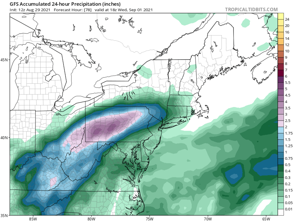
I was thinking the opposite after reviewing 12z models, most seemed to have nudged a bit North. NWS put out a solid discussion pertaining the upcoming situation. .SYNOPSIS... The remnants of Hurricane Ida will bring heavy rainfall and potentially significant flood impacts to the Upper Ohio Valley tonight into Wednesday. Cooler, drier air is expected after the system passes Wednesday night. && .NEAR TERM /THROUGH WEDNESDAY/... Regional radar imagery shows a line of showers developing and strengthening in area of modest CAPE (~500 J/kg) and along/near a diffuse frontal boundary stretching along and just north of I-70. With rainfall rates of up to 2 inches per hour possible, any training segments will pose a flash flood risk. Total amounts in the highest areas will likely be in the vicinity of 2 inches per HREF probabilities, effectively saturating the ground in those areas before tomorrow`s rainfall. This convection should wane towards dusk. Attention then turns to the remnants of Ida and a potentially significant flood event for the Upper Ohio Valley into the Allegheny Mountains. Ida is forecast to move into Appalachia Tuesday night before heading off the Mid-Atlantic coast on Wednesday. Very high moisture content associated with Ida will surge northward into the Upper Ohio Valley along a strengthening frontal/baroclinic zone that will lie right across the forecast area. Strong frontogenetical and isentropic lift in the frontal zone in the right entrance region of the northern stream jet will allow for a band of moderate-to-heavy rainfall to develop and persist across the area. Run-over-run model guidance has been consistent with placing the axis of heaviest rainfall in an area stretching from the Mon Valley to areas northeastward such as Uniontown and Connellsville and then into the Laurel Highlands. 24- hour totals ending 8PM Wednesday look to be around or possibly in excess of 6 inches in this heaviest axis, with rainfall totals dropping off fairly precipitously to north and west. The greatest uncertainty in the rainfall forecast will be across the rainfall gradient , which will encompass the immediate Pittsburgh metro area. HREF probabilities suggest rainfall amounts may be upwards of 4 inches towards the southern portion of Allegheny County, dropping significantly to perhaps just around 1 inch towards the Beaver County border. No changes are currently planned for the flash flood watch. Officially the watch begins at 2am, though rain is expected to begin before that. Wouldn`t rule out a warning or two today with afternoon convection or this evening as the initiate wave of Ida rainfall approaches the area. As far as impacts, we`re anticipating a somewhat similar scenario to significant tropical systems of the past such as Gordon (2018) or even Francis/Ivan (2014). The similarities exist within rainfall totals and duration, though the axis of heaviest rainfall will likely be slightly farther southeast than it occurred with Francis or Ivan. This will cause significant rises in the Monongahela River and its tributaries such as the Youghiogheny and Cheat Rivers. Additionally, flash flooding is likely in those surrounding areas with many smaller streams likely going to exceed bankful. If you live in a flood prone area, please have an emergency plan in place and methods for receiving warning information. Rainfall should begin to exit eastern Ohio and NW PA by noon Wednesday, eventually exiting the entire Pittsburgh forecast area by tomorrow evening once Ida shifts off and cool, drier air ensues. -

Western PA/Pittsburgh Summer Discussion 2021
RitualOfTheTrout replied to Ahoff's topic in Upstate New York/Pennsylvania
Latest trends do seem to have shifted SE with the track and expanse of the heaviest rain. That map looks like so many Winter Storms over the past several years it almost triggers some PTSD lol. Only this time I’ll be fine getting fringed, 1-2 inches will be much more manageable and another tick SE puts most of the city out of significant impact. -

Western PA/Pittsburgh Summer Discussion 2021
RitualOfTheTrout replied to Ahoff's topic in Upstate New York/Pennsylvania
Yeah it's hard to say what to "root" for on this in terms of mitigating impacts. Hopefully some of those rain amounts are overdone at this range. 4-5 inches in an 18-24 hour period will no doubt cause some problems. -

Western PA/Pittsburgh Summer Discussion 2021
RitualOfTheTrout replied to Ahoff's topic in Upstate New York/Pennsylvania
Interesting watching the radar this morning. Not often you can see a clearly defined center of circulation from a tropical storm / remnants moving right towards us. -

Western PA/Pittsburgh Summer Discussion 2021
RitualOfTheTrout replied to Ahoff's topic in Upstate New York/Pennsylvania
Yeah, I'm ready for this pattern to break for a long dry spell. Pool needs drained every other day and my backyard fill project on hold because it's just so muddy. One good thing I guess, the garden is going crazy.


