

RitualOfTheTrout
-
Posts
3,673 -
Joined
-
Last visited
Content Type
Profiles
Blogs
Forums
American Weather
Media Demo
Store
Gallery
Everything posted by RitualOfTheTrout
-

Western PA/Pittsburgh Fall Weather Discussion
RitualOfTheTrout replied to Ahoff's topic in Upstate New York/Pennsylvania
Got a warning for Tornado, looks like three of them in the area, anything sighted or just radar indicated so far? -
Western PA/Pittsburgh Fall Weather Discussion
RitualOfTheTrout replied to Ahoff's topic in Upstate New York/Pennsylvania
Nothing exciting here. Rumble or two of thunder and some heavy rain. -
Western PA/Pittsburgh Summer Discussion 2021
RitualOfTheTrout replied to Ahoff's topic in Upstate New York/Pennsylvania
I'd think areas under that heavy band earlier had to have recorded at least .5-1 more than they got out at the airport but that's pure speculation. -
Western PA/Pittsburgh Summer Discussion 2021
RitualOfTheTrout replied to Ahoff's topic in Upstate New York/Pennsylvania
Overall, looks like the heaviest is now behind us, just some light to moderate showers now but you can see the back edge quickly approaching into eastern OH. -
Western PA/Pittsburgh Summer Discussion 2021
RitualOfTheTrout replied to Ahoff's topic in Upstate New York/Pennsylvania
I made it to work this morning, I'd say I was on Washing Blvd around 6am and it was pouring but still passable and open. If that had been closed when I went to go through I was just going to turn around and go home. As I made it further South and passed Kennywood it was a very light rain and almost no issues. Sort of the opposite of what I expected, figured it would get worse the further South, but it looks like from the City NE is getting slammed right now. Probably had I left an hour later it would be a different story. -
Western PA/Pittsburgh Summer Discussion 2021
RitualOfTheTrout replied to Ahoff's topic in Upstate New York/Pennsylvania
Gotcha, yeah I didn't take into account the timing of your post vs the models I was looking at. The worst is still SE of Pittsburgh and although it seems like whatever the trend is in the last 12-18 hours continues until game time I don't see guidance being the far off but if there are any convective components to the rainfall that will through another variable into the mix. That line moving through now will saturate the ground before the main event for sure. I was hoping to have some clarity, my commute in takes me through various flood prone areas so it would have been nice to make the call on whether to just stay home tomorrow. Last thing I want is to get detoured or stuck on Washington Blvd. -
Western PA/Pittsburgh Summer Discussion 2021
RitualOfTheTrout replied to Ahoff's topic in Upstate New York/Pennsylvania
I was thinking the opposite after reviewing 12z models, most seemed to have nudged a bit North. NWS put out a solid discussion pertaining the upcoming situation. .SYNOPSIS... The remnants of Hurricane Ida will bring heavy rainfall and potentially significant flood impacts to the Upper Ohio Valley tonight into Wednesday. Cooler, drier air is expected after the system passes Wednesday night. && .NEAR TERM /THROUGH WEDNESDAY/... Regional radar imagery shows a line of showers developing and strengthening in area of modest CAPE (~500 J/kg) and along/near a diffuse frontal boundary stretching along and just north of I-70. With rainfall rates of up to 2 inches per hour possible, any training segments will pose a flash flood risk. Total amounts in the highest areas will likely be in the vicinity of 2 inches per HREF probabilities, effectively saturating the ground in those areas before tomorrow`s rainfall. This convection should wane towards dusk. Attention then turns to the remnants of Ida and a potentially significant flood event for the Upper Ohio Valley into the Allegheny Mountains. Ida is forecast to move into Appalachia Tuesday night before heading off the Mid-Atlantic coast on Wednesday. Very high moisture content associated with Ida will surge northward into the Upper Ohio Valley along a strengthening frontal/baroclinic zone that will lie right across the forecast area. Strong frontogenetical and isentropic lift in the frontal zone in the right entrance region of the northern stream jet will allow for a band of moderate-to-heavy rainfall to develop and persist across the area. Run-over-run model guidance has been consistent with placing the axis of heaviest rainfall in an area stretching from the Mon Valley to areas northeastward such as Uniontown and Connellsville and then into the Laurel Highlands. 24- hour totals ending 8PM Wednesday look to be around or possibly in excess of 6 inches in this heaviest axis, with rainfall totals dropping off fairly precipitously to north and west. The greatest uncertainty in the rainfall forecast will be across the rainfall gradient , which will encompass the immediate Pittsburgh metro area. HREF probabilities suggest rainfall amounts may be upwards of 4 inches towards the southern portion of Allegheny County, dropping significantly to perhaps just around 1 inch towards the Beaver County border. No changes are currently planned for the flash flood watch. Officially the watch begins at 2am, though rain is expected to begin before that. Wouldn`t rule out a warning or two today with afternoon convection or this evening as the initiate wave of Ida rainfall approaches the area. As far as impacts, we`re anticipating a somewhat similar scenario to significant tropical systems of the past such as Gordon (2018) or even Francis/Ivan (2014). The similarities exist within rainfall totals and duration, though the axis of heaviest rainfall will likely be slightly farther southeast than it occurred with Francis or Ivan. This will cause significant rises in the Monongahela River and its tributaries such as the Youghiogheny and Cheat Rivers. Additionally, flash flooding is likely in those surrounding areas with many smaller streams likely going to exceed bankful. If you live in a flood prone area, please have an emergency plan in place and methods for receiving warning information. Rainfall should begin to exit eastern Ohio and NW PA by noon Wednesday, eventually exiting the entire Pittsburgh forecast area by tomorrow evening once Ida shifts off and cool, drier air ensues. -
Western PA/Pittsburgh Summer Discussion 2021
RitualOfTheTrout replied to Ahoff's topic in Upstate New York/Pennsylvania
Latest trends do seem to have shifted SE with the track and expanse of the heaviest rain. That map looks like so many Winter Storms over the past several years it almost triggers some PTSD lol. Only this time I’ll be fine getting fringed, 1-2 inches will be much more manageable and another tick SE puts most of the city out of significant impact. -
Western PA/Pittsburgh Summer Discussion 2021
RitualOfTheTrout replied to Ahoff's topic in Upstate New York/Pennsylvania
Yeah it's hard to say what to "root" for on this in terms of mitigating impacts. Hopefully some of those rain amounts are overdone at this range. 4-5 inches in an 18-24 hour period will no doubt cause some problems.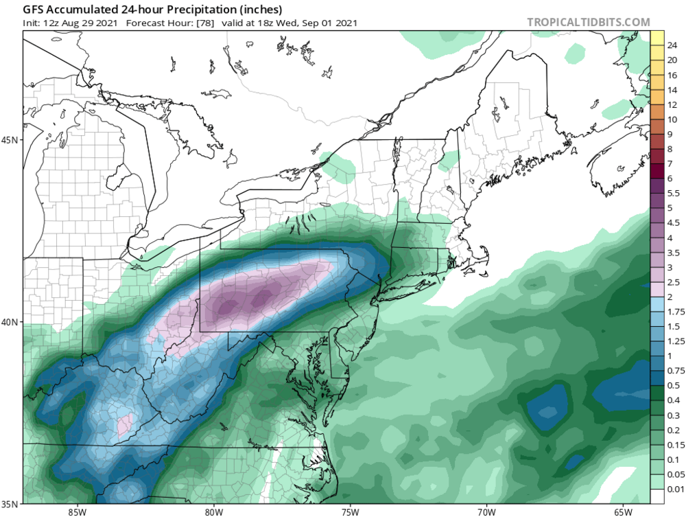
-
Western PA/Pittsburgh Summer Discussion 2021
RitualOfTheTrout replied to Ahoff's topic in Upstate New York/Pennsylvania
Interesting watching the radar this morning. Not often you can see a clearly defined center of circulation from a tropical storm / remnants moving right towards us. -
Western PA/Pittsburgh Summer Discussion 2021
RitualOfTheTrout replied to Ahoff's topic in Upstate New York/Pennsylvania
Yeah, I'm ready for this pattern to break for a long dry spell. Pool needs drained every other day and my backyard fill project on hold because it's just so muddy. One good thing I guess, the garden is going crazy. -
Western PA/Pittsburgh Summer Discussion 2021
RitualOfTheTrout replied to Ahoff's topic in Upstate New York/Pennsylvania
At work, but I heard 3 rumbles of Thunder! wohoo -
Western PA/Pittsburgh Spring Discussion 2021
RitualOfTheTrout replied to Ahoff's topic in Upstate New York/Pennsylvania
That's interesting, I hadn't checked the records / realized May 9th had that many cold records. -
Western PA/Pittsburgh Spring Discussion 2021
RitualOfTheTrout replied to Ahoff's topic in Upstate New York/Pennsylvania
I just hope when this pattern ends we don't shoot right into mid 80s and humidity. Average May weather is pretty enjoyable so it does suck to be so cool right now. On the other hand, it wouldn't have taken much to be slightly colder to break some May snowfall records today. If it's going to be 40 and rain may as well be 35 and snow in my opinion and make it interesting. -
Western PA/Pittsburgh Spring Discussion 2021
RitualOfTheTrout replied to Ahoff's topic in Upstate New York/Pennsylvania
Just sprinkles so far imby today. Think I've only heard thunder once this Spring which is unusual. -
Western PA/Pittsburgh Spring Discussion 2021
RitualOfTheTrout replied to Ahoff's topic in Upstate New York/Pennsylvania
Yeah that was a heck of a night here... Phones went off with the warning and woke us up, my wife was like should we be worried, I looked outside and saw the rain going horizontal as the radar loaded on my phone and yelled yes get the kids and let's get in the basement. We could hear patio furniture sliding across the deck. We were without power for a solid 12 hours afterwards. Luckily no damage other than a destroyed trampoline. I remember being glad I had a dying 80 ft locust tree near the house cut down 2 weeks earlier. Wouldn't mind some thunderstorms either but can do without the tornado. -
Western PA/Pittsburgh Spring Discussion 2021
RitualOfTheTrout replied to Ahoff's topic in Upstate New York/Pennsylvania
Maybe last snow of the season on tap. I say bring it on, unrelenting summer heat will set in soon for a good 3-4 months either way. -
They don't make them much more miserable than this that's for sure as far as spring days go.
-
Ill say.. Amazing storm. Doubtful we ever see something of that magnitude again in our lifetime but possible a smaller storm could still produce locally similar results. Heck of a blizzard taking shape out west.
-
There’s a reason winters like that are memorable; they are rare. Your not going to have record breaking seasons every year and if that’s your bar you’ll be disappointed frequently. It was a great winter, March looking warmer but not all that unexpected once the SSW effects fade. Still will probably have some shots at snow. Some data indicates blocking is favored following a predominantly -AO / NAO winter so something positive to see if that pans out next season. Seems weird not having to check the models daily but whatever happens with regards to snow hopefully we will have some thunderstorms to track soon.
-
Looking at the 3k NAM the city gets about .1 -.15 qpf, so yeah if you can manage 10:1 ratios I think that's a reasonable ceiling. Further NE of the city you get the more qpf and should be less warm air so those areas should do slightly better.
-
It's really been a solid deep winter feel this month so far. No matter what happens going forward this goes in my book as a great winter. Started December 1st, big storm mid December, White Christmas, No real torch periods through January, then February with the prolonged stretch of snow cover and cold days. Multiple 4-5in snow events sprinkled through the season with multiple days of at least some snow in the air and we will finish at least a foot over average. Can't draw one up much better than that and still a shot possible for some March magic.
-
Crisp 24 degrees tonight with light snow falling again tonight. Nice night for a walk. Should make for another nice scene tomorrow, I love how fresh snow sparkles in the early morning.
-
Looks like NWS trimmed down any accumulations for tonight too now. Tomorrow still a shot at some snow showers so we will see if anyone gets lucky. Not worth analyzing anything for next Friday imho other than just quick glance to see if it’s still somewhere on the map for the next couple days. Monday looks like rain /snow mix at best right now unless all your eggs are in the CMC basket.
-
Euro nailed this one for my yard. It showed about an inch or less and that’s what I ended up with. Will have to see what happens once the winds back to W /NW later today and through the day tomorrow. Won’t take much for that to beat this storm.


