Sey-Mour Snow
-
Posts
6,904 -
Joined
-
Last visited
Content Type
Profiles
Blogs
Forums
American Weather
Media Demo
Store
Gallery
Everything posted by Sey-Mour Snow
-
 Would be a widespread outage for southern ct verbatim 12” of snow at 33 degrees
 -
It was a Flop... February 2024 Disco. Thread
Sey-Mour Snow replied to Prismshine Productions's topic in New England
Wild loaded look for Presidents’ Day -
Box going 4-10” with wind for the watch . Upton going 6-10” most in hills. Power outages will be a major issue with wind and on the southern extent of significant snow.
-
It was a Flop... February 2024 Disco. Thread
Sey-Mour Snow replied to Prismshine Productions's topic in New England
Ya they are nice -
It was a Flop... February 2024 Disco. Thread
Sey-Mour Snow replied to Prismshine Productions's topic in New England
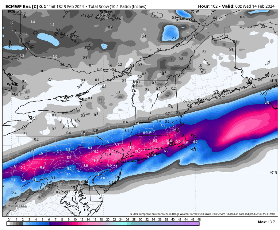
If anyone wanted to know what EURO was going to do post day 10 take a look at the control run for sh*ts and giggles.. Some wild solutions are likely in the 10-15 day timeframe -
Mid level tracks are the reason not qpf
-
EURO has been so damn jumpy unlike GFS for a change.. Last run that was shifted 150 miles SW
-
Not about jacking, the further north it is the more mixing for southern 3rd of CT, you are just far enough north to be pretty solid no matter what unless this just goes wagons north..
-
It shifted thats why I posted that it shifted .
-
Much juicier yes , heaviest axis north though, I'd like to see that settle down over us tomorrow .. Not really worried with so much guidance south..
-
I measured it with radar scope, might get like 65.5 miles if you use your astronomer buddy's protractor.
-
That's about a 65 mile shift north with the heavy snow axis on EPS.. Yikes
-
I agree, that was just the high end tease of what’s possible ..
-
I actually really like where we sit, with plenty of guidance south and GFS / EURO north ..
-
Ray just sitting back smiling after a 25" dopamine drip.. thats probably the best run yet for the entire New England forum 3-6" south shore that 12-18" just inland for most with an 18-24" stripe in all of NE mass
-
lmao its way north
-
RGEM looks great too, great start to 00z would be a crushing for all of SNE.
-
ya from that primary tracking into West Virginia
-
It's well south and looks good.
-
Ya it just has the low pressure off of Carolina/VA coast at 84, thats pretty damn south.. But it has good precip well north.
-
ya its actually believable at 84.. same timing and thermals as the big boys. Looks a bit weaker, south, and colder , but it's a possible solution I guess.
-
FWIW long range NAM is way south and looks like it would be good for SNE extrapolated
-
only 6 hours of my daily 20 hour fast.. People could use a break from the constant insulin spikes..
-
Lets get Kevins mega band from SWCT to CT to RAY and many people are happy
-
The EURO control is replacing the current EURO as the new operational later this year I believe.. So I've been looking at that as well. The control is always very close to the current OP especially inside day 6-7.. Since 18z op only went out to 90 here's what the control had at 18z for the rest of the storm.