Sey-Mour Snow
-
Posts
6,904 -
Joined
-
Last visited
Content Type
Profiles
Blogs
Forums
American Weather
Media Demo
Store
Gallery
Everything posted by Sey-Mour Snow
-

It was a Flop... February 2024 Disco. Thread
Sey-Mour Snow replied to Prismshine Productions's topic in New England
Ensembles really like CNE and NNE on the 12-13th.. -
It was a Flop... February 2024 Disco. Thread
Sey-Mour Snow replied to Prismshine Productions's topic in New England
Legit chance you get 10 weenies on that one .. It's day 12.. Need a legit PNA spike to bring something north as we've been saying for that timeframe.. -
It was a Flop... February 2024 Disco. Thread
Sey-Mour Snow replied to Prismshine Productions's topic in New England
Meh .. 24” or bust -
It was a Flop... February 2024 Disco. Thread
Sey-Mour Snow replied to Prismshine Productions's topic in New England
LBSW on 18z 975 SE of BM ..Such a thread the needle .. it's actually mostly rain for south coast.. -
It was a Flop... February 2024 Disco. Thread
Sey-Mour Snow replied to Prismshine Productions's topic in New England
Deep interior favored on GEFS and EPS with this one.... for now.. Will be a ton of waffling around the next 6 days.. Definitely a thread the needle look with not much cold to be found, 6z gfs shows you how to get it done. Will need a bomb with the perfect track to get a good event. Some pretty big timing differences on GEFS and EPS anywhere from Monday to Thursday AM also about 25% of the members are really amped.. -
It was a Flop... February 2024 Disco. Thread
Sey-Mour Snow replied to Prismshine Productions's topic in New England
Still looks fine, it’s a bit “troughier” out west but that’s what you need for the storms. Just don’t want the mega trough out in the PAC NW. -
It was a Flop... February 2024 Disco. Thread
Sey-Mour Snow replied to Prismshine Productions's topic in New England
If you take a look at the indies there’s actually more like the op a ton of interior northeast hits and a few at the coast. -
It was a Flop... February 2024 Disco. Thread
Sey-Mour Snow replied to Prismshine Productions's topic in New England
Verbatim there’s a ton of cold and a great airmass, it cuts west before transferring so the mid levels warm south of the pike and a ton of mixing. All we can take out of this run is that it has a juicy storm again -
It was a Flop... February 2024 Disco. Thread
Sey-Mour Snow replied to Prismshine Productions's topic in New England
Exactly plus with that subtropical moisture feed I think we will be fine. -
It was a Flop... February 2024 Disco. Thread
Sey-Mour Snow replied to Prismshine Productions's topic in New England
RAY : “He said Nashua and suppression”
-
It was a Flop... February 2024 Disco. Thread
Sey-Mour Snow replied to Prismshine Productions's topic in New England
Impressive, family? -
It was a Flop... February 2024 Disco. Thread
Sey-Mour Snow replied to Prismshine Productions's topic in New England
I’m thinking they may be the same person? Kinda odd to have two people so similar in posting style to just randomly pop up and start mass posting -
It was a Flop... February 2024 Disco. Thread
Sey-Mour Snow replied to Prismshine Productions's topic in New England
Cosgrove already alerting the masses for PD3 .. but seriously things do look very favorable for something big in that time period… lets hope it’s a uniform snowfall for all . -
It was a Flop... February 2024 Disco. Thread
Sey-Mour Snow replied to Prismshine Productions's topic in New England
Well ya not the greatest set up with that low in Canada on that 18z run . 60 more gfs cycles to lock it in. I’m sure we will get a few warmer runs and a few SECS runs -
It was a Flop... February 2024 Disco. Thread
Sey-Mour Snow replied to Prismshine Productions's topic in New England
No, I'm using a site you actually pay for.. -
It was a Flop... February 2024 Disco. Thread
Sey-Mour Snow replied to Prismshine Productions's topic in New England
LMAO that is one of your worst posts ever. You have been better lately.. You literally picked the only bad frame that storms gives your area 6" + and CNE 12-18" of clown snow.. -
It was a Flop... February 2024 Disco. Thread
Sey-Mour Snow replied to Prismshine Productions's topic in New England
especially love that EPS look tremendous blocking in the Arctic. Things really start shuffling by day 8-9.. And that pattern starts locking in by day 10-12.. We should be tracking a region-wide plowable event by sometime next week hopefully some 60s too while we track.. -
Noticed them the past week in the elementary school playground dozens of them.
-
Geeze, I’m only 20 miles south of you yet it looks like you live in a different country. Looks like March 31st here geese are out not a snow pile in sight.
-
It was a Flop... February 2024 Disco. Thread
Sey-Mour Snow replied to Prismshine Productions's topic in New England
NAMs with an outlier cold solution and weenie SWCT 2-4” snow band early Friday AM. Every other piece of guidance is far too warm., -
It was a Flop... February 2024 Disco. Thread
Sey-Mour Snow replied to Prismshine Productions's topic in New England
I like the 3" spot in Maine.. -
It was a Flop... February 2024 Disco. Thread
Sey-Mour Snow replied to Prismshine Productions's topic in New England
If I got teased like that again with multiple storms of 12-24” within 25 miles of me id retire from weather. -
It was a Flop... February 2024 Disco. Thread
Sey-Mour Snow replied to Prismshine Productions's topic in New England
Lol no I had a trace on my truck -
It was a Flop... February 2024 Disco. Thread
Sey-Mour Snow replied to Prismshine Productions's topic in New England
“Snowing” now -
It was a Flop... February 2024 Disco. Thread
Sey-Mour Snow replied to Prismshine Productions's topic in New England
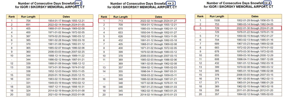
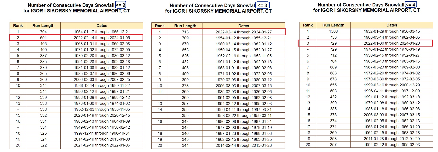
BDR futility chart from Ralph Wx Obs on twitter. This type of stretch has happened before for BDR. Seems like the real anomaly is the extremely snowy stretch BDR had in the 2000s. Currently in the 729+ day mark without a 4”+ snowfall which is no where near the record which was 1508+ days in the 50s. It’s not uncommon there on the immediate shore to go a few years without a decent snowfall.