

Sey-Mour Snow
-
Posts
6,904 -
Joined
-
Last visited
Content Type
Profiles
Blogs
Forums
American Weather
Media Demo
Store
Gallery
Everything posted by Sey-Mour Snow
-
 funny now that you say this .. I called this with All snow earlier in the week worst case scenario would verify .. Today would trend south and screw up our 65 degree day .. and Sunday would trend north and screw up our accumulating snow ..
 -
it was actually pretty nice 55-60 over most of the tri-state yesterday 57 here .. Euro had today warm sectored and sunny .. today's storm just trended south (65-75 in DC Baltimore and Philly) if not it would have been mild as well
-
Yes, this seems much more realistic to me .. the snow in NNE is from today .. matches up with our map pretty well too ..
-
again you still look fine, I'm just "deflating" me and Scott and the south coast lmao
-
It's been trending north not south, I don't see how that stops.. Coast has absolutely no chance at anything.. This is well inland north of 84 and/or elevation IMO ..
-
congrats , might rent a wagon to go north so I can car pool the southern weenies up to your hood so we can see some actual snow..
-
Ya I’m still leaning goodbye lol .. maybe we will catch a bone and it can be a tick or two south. I’ll check back in tomorrow.
-
Pretty low odds of you matching last March
-
Ya usually 500' + gets it done to see a big difference around here.. Then I notice another uptick around 1000'
-
I wouldn't toss the clowns verbatim 84 north .. It's like 1-2" rates for a few hours 32-33 degrees .. But it's the euro and it's 18z that won't verify so who cares lol just analyzing for fun
-
About Hartford north stays isothermal
-
I know I mentioned that earlier it's +1 over most of CT
-
The EPS has been pretty jumpy too for an ensemble.. Our first storm of the year when you got 18" .. It had my area in the 8-10" zone right up until game-time until the rug got pulled out and everything shifted north..
-
I still believe nothing until we get multi guidance agreement .. rain / snow / shredded mess all still on table.. Although your spot in NE CT at 1000' has the most wiggle room and is pretty likely to see plowable snow
-
Dude wtf is going on with the EURO ... I mean it actually matches up with GFS decently now .. 18z GFS and EURO have a predawn snow start time Sunday for CT lol no one is expecting that .. I feel like that maximizes the cold and snow potential in CT because temps don't rise into the upper 30s like originally forecast .. rather they are 32-33 when precip moves in
-
ya wild has a band of 1"+ per hour heavy wet snow pre dawn Sunday - It's acting like the NAM with these swings in sensible weather and its only 60-72 hours out as well ..
-
Ya I thought it was all rain at first glance.. Not quite sure how it's computing snow in Central CT with 850 temps of +1
-
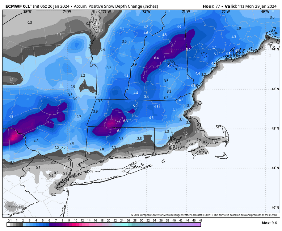
The run to run changes are wild on the Euro... Moderate to Heavy Snow starts at 2-4am Sunday on the 18z EURO for Western New England.. A good stripe of 6-8" 84 north .. It's a thump of snow , break, then some CCB snow tries to form at the end but its a ragged precip shield ..
-
when it's 33-34 degrees and crappy rates
-
ya rain changing to snow with no dynamics and 33-34 degrees wont accumulate most places outside heavy bands and hills
-
Gotta love DT going all out on a Major snowstorm at 12:55pm why not take a peak at EURO before you publish.. some major balls/stupidity to post what he posted before the 12z came out when most had a strong hunch it would be much less impressive at 12z.
-
The King permanently dethroned forever.. From a widespread warning event to a coating to 2" for most lmao .. Went from 1.7" wpf to .3" qpf over my area
-
not even close lol
-
Speaking of what feels like SWCT always feeling like the rain jack... The HRAP has a 47" jack of precip over BDR over the past 180 days.. Highest anywhere other than the Cascades and a few 49" spots near Tallahassee and Miami.. Thats double the average rainfall
-
Lol well I only say those two towns bc they are the nearest hills to Orange ..


