Sey-Mour Snow
-
Posts
6,893 -
Joined
-
Last visited
Content Type
Profiles
Blogs
Forums
American Weather
Media Demo
Store
Gallery
Everything posted by Sey-Mour Snow
-
 4.0" 29.5 . pounding out
 -
Grass is 100% covered for the first time since Jan 2022.
-
Hrrr has 4-6" after 8am for your area , lets hope thats right
-
Thanks but I'm sure you'll get into some goods, need to spread the wealth on this positive bust
-
radar starting to light up for the whole state including the areas that got skunked so far
-
5" Warren , northern CT definitely cashing in, only coatings to 1" at the shore so far..
-
Persistent fronto band just south of 84 wont quit
-
I sucked this storm I must admit, our bet is from late January on no snow over 3" anywhere in New England before Valentines Day.. He was 48 hours off..
-
It's too warm in Mid-town urban heat effect.. best banding so far is just inland 2-4.5" widespread from merritt parkway to rt 84.. 4.5" new fairfield .. 8-11am should crush along shore .. Also with several 3"+ reports I won the bet against @qg_omega
-
Congrats dude how you doing there
-
Ya it’s pretty annoying , we know mid levels looked great but who honestly expected Southington to wake up at 5am to 1-2” per hour rates. We enjoy now take the L for the forecast and enjoy a snow day with the kids. Congrats @The 4 Seasons you the champ on this one
-
29.8 out heavy snow over an inch it seems edit 1.8”
-
Meso issued for shore 1-2+ for several hours
-
Ya I feel the same
-
Evidently that’s got nothing on Drake..
-
Ya that’s a major outlier 1-1.3” liquid south of 84. Cut back northern edge
-
Don't know if this was posted.. Yes @qg_omega called it ..
-
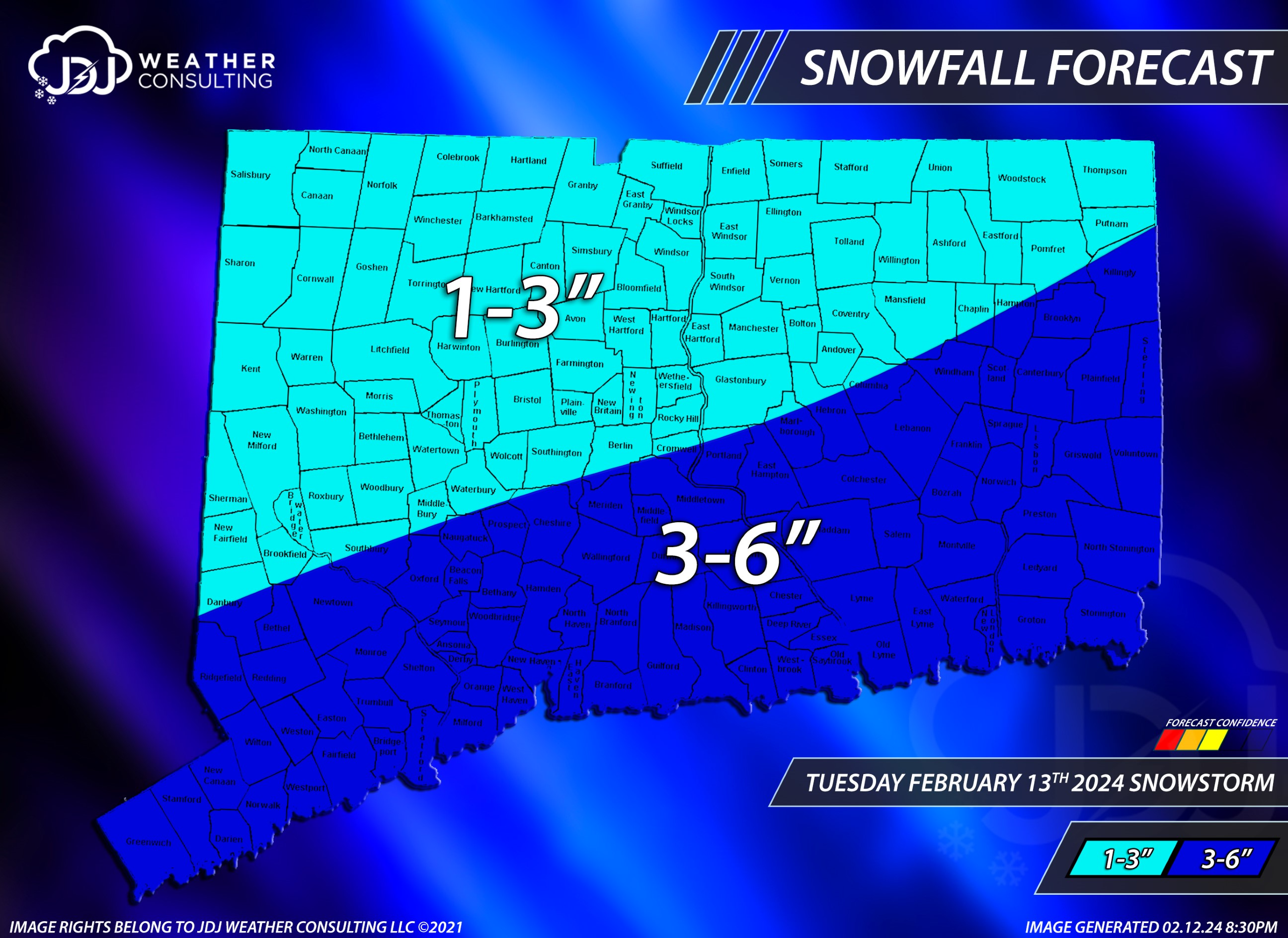
After an in depth discussion with @Torch Tiger @jbenedet and @qg_omega we decided to lower totals. "GIDDY UP" *Disclaimer @The 4 Seasons does not approve of this map.

-
has anyone else seen a bunch of large flys the past two days? I've had three in two different indoor locations? The low 60s Saturday woke them up?
-
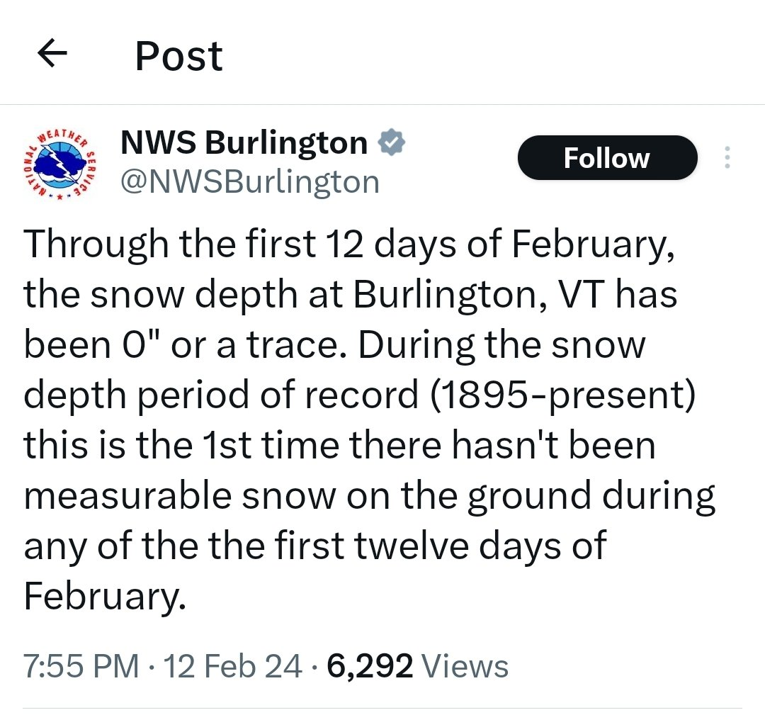
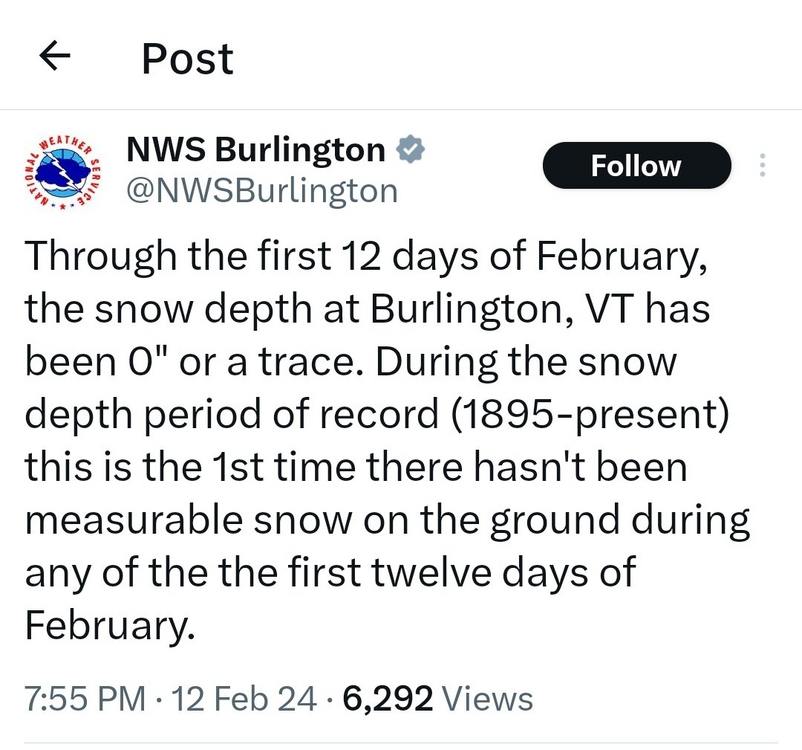
Parts of CT and Mass were well within the 12-18" cone at 18 hours out to potentially see zero inches of snow. @ORH_wxman how many times has that happened this close in?
-
Best part is I may owe @qg_omega $25 while he's sitting there smiling when no one sees 3" tomorrow
-
The rug has been pulled out for most!
-
Been thinking the same thing all day
-
Really hope you do well