Sey-Mour Snow
-
Posts
6,904 -
Joined
-
Last visited
Content Type
Profiles
Blogs
Forums
American Weather
Media Demo
Store
Gallery
Everything posted by Sey-Mour Snow
-
I have zero trust in Euro it’s an outlier as of now in terms of sustained cold. The way I see it is we cool down next 7-10 days to at or just below normal with maybe one really cold day and a wintry threat. then hopefully warm up last week of March to a tad above normal at least. First half of March will end up +9 to + 12 for many after we touch 60 first half today which is wild.
-
CoastalSeaBreeze?
-
71! 12z gfs has a week of temps around 40, then right back to Morch last week of March.
-
Tomorrow is 62-68 for CT as well
-
Morch 2012 continues
-
Up 5 from yesterday here 62 again already . Think we make a run at 66-67 here.
-
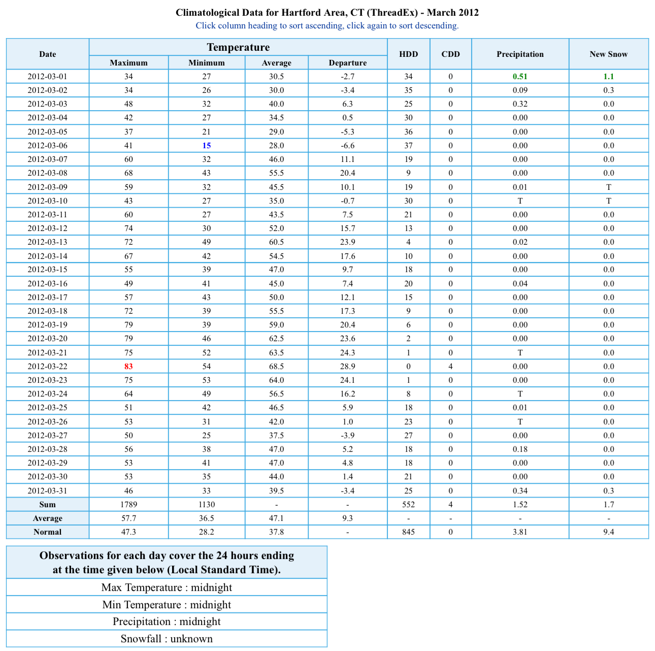
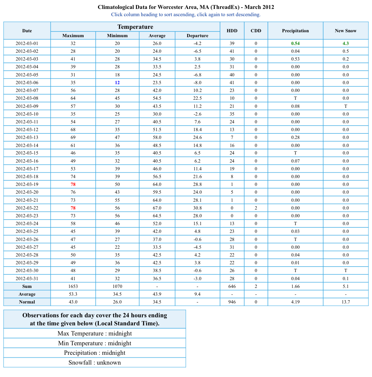
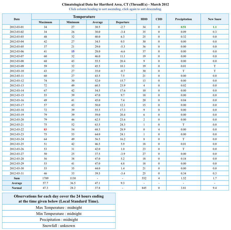
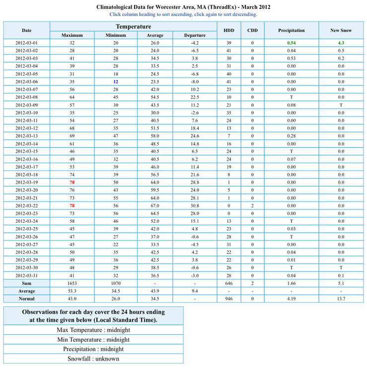
No one Morch 2012 to me stands out for the 10-15 days above 60 degrees. Here’s the actual numbers. No 90s … Barely 80 just one day over 80 at BDL none at ORH. the first half of this month will definitely be similar to Morch 2012 but the 2nd half of this month will probably just be seasonable. Using the BOX forecast for BDL next two days. You get an average high of 54.2 the first half of March 2024 compared to 52.9 for the first half of March 2012. also to note 5.1” of snow at ORH 1.7” BDL and a pretty strong March arctic shot early in the month with a record low.
-
Definite positive bust last two days in the MOS department
-
62 again today so far might get to 65 before the winds shift. What a nice week, maybe 65-70 tomorrow and Friday? Nice start to Morch!
-
2.90” another rain storm around 3” several this winter…
-
1.03” already back yard flooded again
-
ya if that verifies F this Winter! You can see it now, the weenie long range will finally verify this one time once the calendar flips to spring .. But it'll be too late and still produce 30s and rain.
-
 Ya it was very loud. Just no “Damageinseymour” wind reports were meh locally
 -
When do the winds start? Asking for a friend .
-
It was a Flop... February 2024 Disco. Thread
Sey-Mour Snow replied to Prismshine Productions's topic in New England
Damn! What a time to be in Chicago kinda jealous -
It was a Flop... February 2024 Disco. Thread
Sey-Mour Snow replied to Prismshine Productions's topic in New England
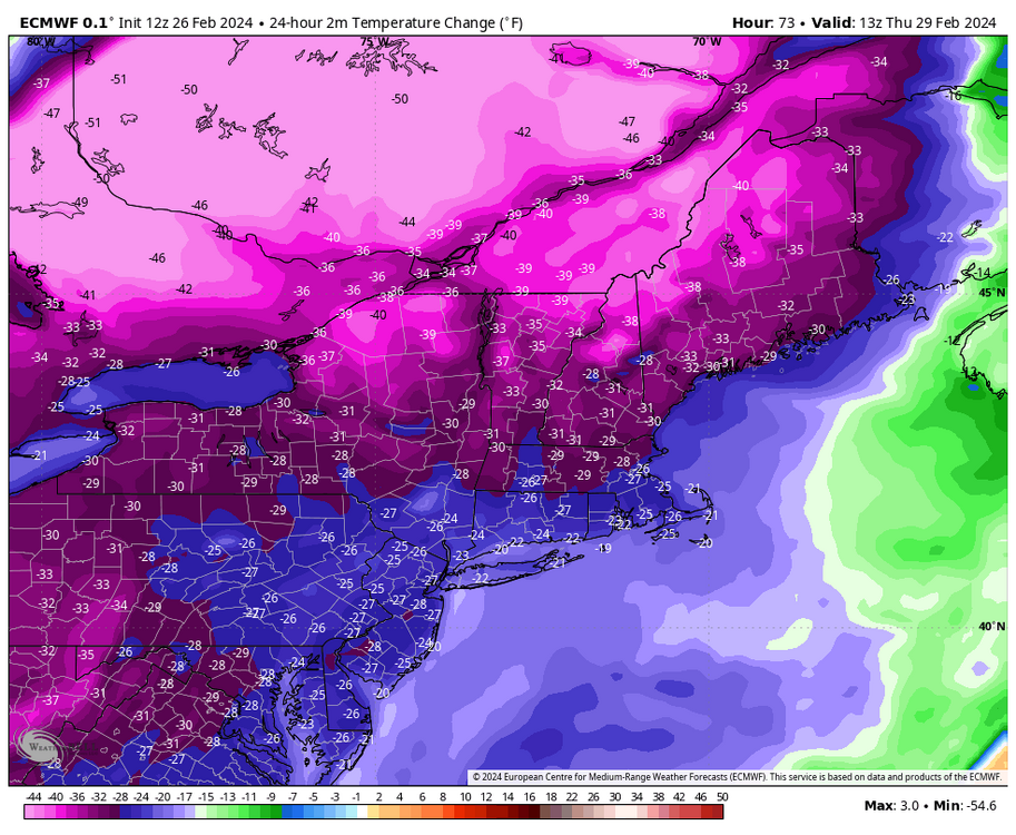
Highs near 60 early in the week. Wind chills in teens and 20s Thursday. With a 3 hour drop of 15-25 degrees for New England.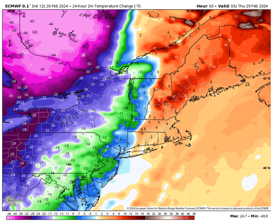
-
Ya that 96 in April was the highest temp. 95 in September and 94 in early June
-
April 14th was 96 at BDL - 5 days in a row 76+
-
We were mid to upper 90s mid April last year..
-
It was a Flop... February 2024 Disco. Thread
Sey-Mour Snow replied to Prismshine Productions's topic in New England
Ya that would be welcome by all.. All out torch .. Last seasonable day would be this Sunday .. Then we go 50 and 60s until mid March with probably a few days around 70 or so and dry weather to boot -
Saturday February 16th - Another CT/ Cape special?
Sey-Mour Snow replied to Sey-Mour Snow's topic in New England
2.7 and .5 for 3.2” total -
It was a Flop... February 2024 Disco. Thread
Sey-Mour Snow replied to Prismshine Productions's topic in New England
Just looking at wiz’s chart BDL is hitting 70 over the last 20 years just as frequently as the 1960-1980 period. as far as 80 . BDL hit 80 4 times before 1990 3 times since 1990. off first glance 60s seem more prevalent recently -
It was a Flop... February 2024 Disco. Thread
Sey-Mour Snow replied to Prismshine Productions's topic in New England
Ya 70s in March aren’t unusual. I remember one year maybe 97 or 98 we hit 88. -
It was a Flop... February 2024 Disco. Thread
Sey-Mour Snow replied to Prismshine Productions's topic in New England
Not too slow lol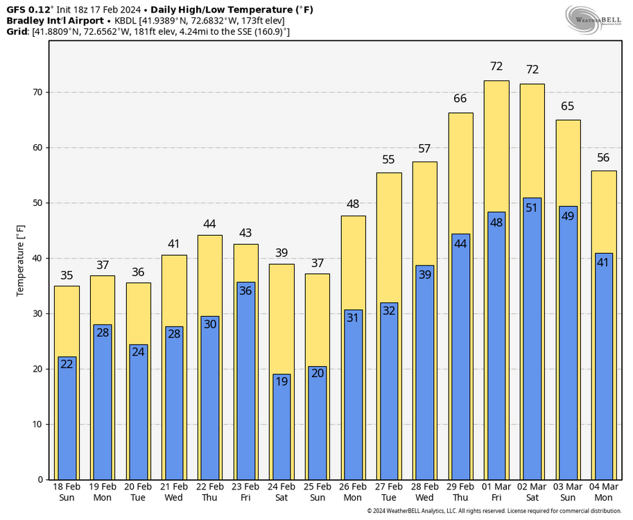
-
20.2” on the season