Sey-Mour Snow
-
Posts
6,904 -
Joined
-
Last visited
Content Type
Profiles
Blogs
Forums
American Weather
Media Demo
Store
Gallery
Everything posted by Sey-Mour Snow
-
Enjoy it we freeze in the pool and wear hoodies at night next week I’m fine with a week break of the steam bath.
-
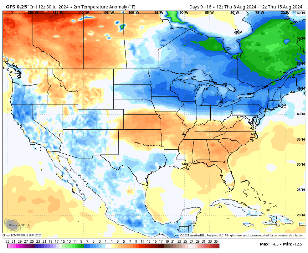
Summers back broken by end of first week of August? It’s usually hard to get big sustained heat after Mid-August.

-
2012
-
What year?
-
Stamford and extreme SWct got hit good
-
Another weak warning for New Haven County
-
Strongest cell with winds now headed for Trumbull.
-
Looks like one goes south and one goes north of Trumbull.
-
Yes I agree.
-
Yes, in all honesty there isn’t. It’s all sheltered by Long Island with no wave action and a bunch of shells and seaweed. I go to Rhode Island .
-
None
-
Ya ensembles reload the heat nationwide days 10-15
-
70+ dews happen in October every few years too.
-
I’m right in the coolest spot 78 in Ludlow still a great day in the pond.

-
Wagons north
-
It’s absolutely disgusting out there. Too hot for me , 88/78 at the house
-
Good thing we had that comfortable break today like WTNH mentioned. Max heat index only 101 today felt great
-
GFS is pretty alarming for mid to late week several more inches of rain likely - possibly widespread with the convergence over us in between the upper level low to the west and Bermuda high . PWATS through the roof
-
Unreal 22.90” since April 1 and 10.02” since June 14.
-
9” of rain and counting in the gauge in the last 21 days. Wild after a very dry first 2 weeks of June.
-
Tropical down pours close to an inch in less than 15 min
-

Sunday, June 30, 2024 Thunderstorm Thread
Sey-Mour Snow replied to weatherwiz's topic in New England
Seems like the intense winds winds were very isolated this time.. About as meh as you can get with a storm here, though another 1"+ of rain.. MTD now over 7 inches. -
Sunday, June 30, 2024 Thunderstorm Thread
Sey-Mour Snow replied to weatherwiz's topic in New England
Rain train setting up for south-central CT -
Sunday, June 30, 2024 Thunderstorm Thread
Sey-Mour Snow replied to weatherwiz's topic in New England
They canceled this warning for Bridgeport worst one I’ve ever seen. -
Sunday, June 30, 2024 Thunderstorm Thread
Sey-Mour Snow replied to weatherwiz's topic in New England
Except snow