Sey-Mour Snow
-
Posts
6,822 -
Joined
-
Last visited
Content Type
Profiles
Blogs
Forums
American Weather
Media Demo
Store
Gallery
Everything posted by Sey-Mour Snow
-
GFS is a scorcher again starting Tuesday til end of run .. seems to always start at day 7 though …
-
Seriously sucks for a pool party , too many clouds, cool, umbrellas won’t stay up, leaves accumulating in the pool, meh !
-

May 2024 Discussion - Welcome to Severe Season!!!!
Sey-Mour Snow replied to weatherwiz's topic in New England
That line just blasted through with an additional 1.00” .. 1.47” on the day after this mornings rain. -
May 2024 Discussion - Welcome to Severe Season!!!!
Sey-Mour Snow replied to weatherwiz's topic in New England
75/70 here in SWCT some 80/70 obs showing up closer to NY border -
May 2024 Discussion - Welcome to Severe Season!!!!
Sey-Mour Snow replied to weatherwiz's topic in New England
Ya I was outside in Middletown all day I got fried mostly sunny until about 3-4pm.. -
April 2024 Disco- SNE’s favorite month
Sey-Mour Snow replied to HoarfrostHubb's topic in New England
Ya 85/68 is perfect hot enough for pool weather and outdoor activities are still manageable 75 dews aren’t too workable/ enjoyable at all -
April 2024 Disco- SNE’s favorite month
Sey-Mour Snow replied to HoarfrostHubb's topic in New England
34.0 for a low -
April 2024 Disco- SNE’s favorite month
Sey-Mour Snow replied to HoarfrostHubb's topic in New England
Most trees are starting to leaf out here at 600’ -
April 2024 Disco- SNE’s favorite month
Sey-Mour Snow replied to HoarfrostHubb's topic in New England
Another 2.3” here unreal -
April 2024 Disco- SNE’s favorite month
Sey-Mour Snow replied to HoarfrostHubb's topic in New England
Horrible trends in 12z guidance hopefully that changes. GFS is just atrocious through day 15. -
April 2024 Disco- SNE’s favorite month
Sey-Mour Snow replied to HoarfrostHubb's topic in New England
75! What a day! First round of good yard work done - Scotts 3:1 laid ahead of the rain this week. -
April 2024 Disco- SNE’s favorite month
Sey-Mour Snow replied to HoarfrostHubb's topic in New England
Ya same here. 70-75 across many areas already -

-
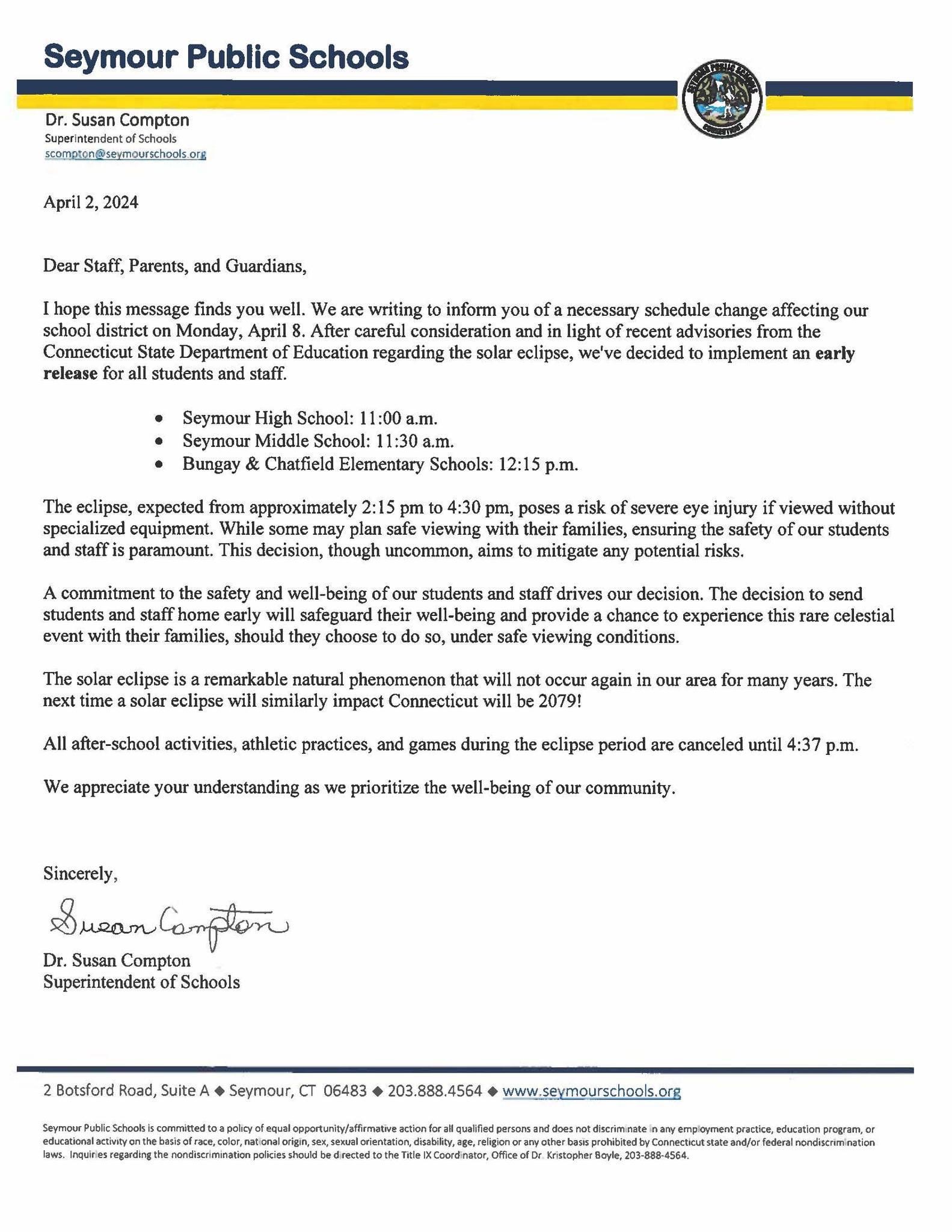
Any other school districts going with half days Monday? Our district just announced this afternoon that the kids will get out between 11am high school to 12pm elementary for the safety of the students.
-
Significant Miller B Nor'easter watch, Apr 3rd-4th
Sey-Mour Snow replied to Typhoon Tip's topic in New England
From the few times I looked over the winter it has/had a pretty significant cold bias like the FV3 -
Significant Miller B Nor'easter watch, Apr 3rd-4th
Sey-Mour Snow replied to Typhoon Tip's topic in New England
Canonical PDC CC -
Significant Miller B Nor'easter watch, Apr 3rd-4th
Sey-Mour Snow replied to Typhoon Tip's topic in New England
48” over your area no big deal -
Lol well to be fair like 90% of News Englands population is in SNE. Edit just checked 79% of New Englands population is in SNE.
-
No one lives there
-
Hopefully a repeat Saturday
-
What a day 55-65 across a good chunk of SNE currently
-
Ya the cold stretch knocked it down 3 degrees. It definitely felt worse than what the numbers show but still +7 for the month. Few days of 55-60 coming will probably finished working +8 for the month in CT at least.
-
There is none as of now, we have to wish in into existence. Hopefully second half warms up after the cool first half
-
Euro still a whiff
-
I'm down! We already got our Morch 2012 Sr the first half of the month, lets get one more snowstorm before we torch 2nd half of April ideally, probably going to be 30s and rain though or a whiff Friday though..