

wxsniss
-
Posts
5,786 -
Joined
-
Last visited
Content Type
Profiles
Blogs
Forums
American Weather
Media Demo
Store
Gallery
Everything posted by wxsniss
-
12z CMC and UK also had hints of more potent backend vorticity rounding the trough which would improve coastal development Just catching up... been a while since we've been staring at a region-wide foot+ with lots of buffer. Quick look, key variables determining 12"+ vs. 20"+ in SNE include • proficiency of coastal development, and how well it can vertically stack and better develop a comma head • ratios: 12-15:1? • CF enhancement for eastern areas? Thanks @MegaMike for that link earlier... here's an NBM product I haven't seen before, run 13z Jan 21:
-
January 2026 regional war/obs/disco thread
wxsniss replied to Baroclinic Zone's topic in New England
0z EPS jumped ~150 north compared to 12z EPS mean QPF now 0.7-1" all of SNE -
January 2026 regional war/obs/disco thread
wxsniss replied to Baroclinic Zone's topic in New England
Agree I've been browsing through NARR there are H5 similarities to Jan 1994 and Feb 2013... it's nice to be in a favorable setup for a change... in the what's-more-important cold vs. qpf debate for optimizing chances, we're rolling with cold for a few weeks and I think we do well -
January 2026 regional war/obs/disco thread
wxsniss replied to Baroclinic Zone's topic in New England
Quick glance and thoughts, sorry if posted earlier: • GFS / AIGFS alone in terms of timing of stream interactions, too little too late for SNE... can't be certain it's wrong, but I favor this having impact on SNE, and potentially very big impact if we can get northern stream interaction sooner rather than a later infusion of trailing energy at exit • some similarities to Feb 15-18 2003 aka PD2 at H5... https://www.meteo.psu.edu/ewall/NARR/2003/us0217.php • interesting that AI-GFS vs. AI-EC very different from each other compared to their strong consensus for Jan 18 event • lost in the trenches of forecasting an upcoming event... this definitely feels like we're turning a corner in SNE compared to last 4 years -
Rise of the Machines: January 18-19 Winter Storm Obs Thread
wxsniss replied to WxWatcher007's topic in New England
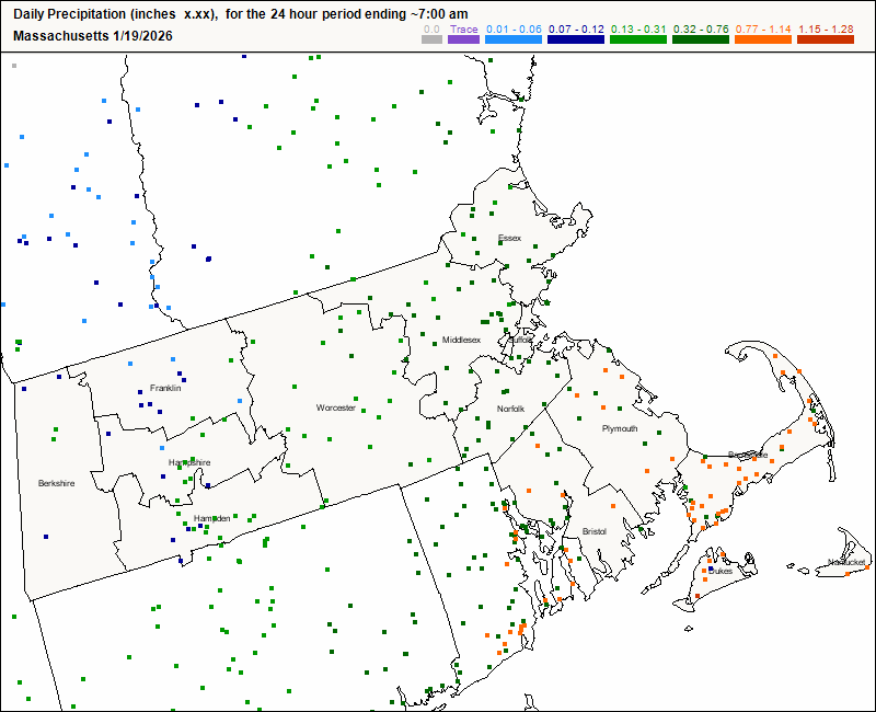
Appreciate it Vortex The flaws of KBOS/Logan snow reports (at some point near a water treatment area? jutting out into the ocean?) and poor representation of the downtown area such as Boston Commons are very familiar to this board lol In this specific case, my own measurement of 5.5” in Coolidge Corner area and neighboring PNS reports are validating… even with some margin of error, the city probably has not yet broken 6”: 1 S Brighton 5.5 in 1015 AM 01/19 Public Logan AP 5.3 in 1041 AM 01/19 Official NWS Obs Chelsea 5.2 in 1043 AM 01/19 Trained Spotter Boston 6.5 SW 5.1 in 0700 AM 01/19 COCORAHS West Roxbury 5.0 in 0940 AM 01/19 Trained Spotter Chelsea 4.9 in 0848 AM 01/19 Trained Spotter Boston 3.1 SW 4.7 in 0700 AM 01/19 COCORAHS Logan AP 4.6 in 0703 AM 01/19 Official NWS Obs Chelsea 4.5 in 0800 AM 01/19 Trained Spotter West Roxbury 4.3 in 0815 AM 01/19 Amateur Radio Logan AP 3.4 in 1200 AM 01/19 -
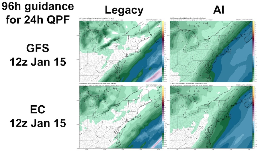
Quoted the above to help consolidate our tallies and impressions into the same thread for rolling reference... I agree: for Jan 18-19 2026 event, my impression was the AI models crushed legacy physics models in the 2-5 day range... we had multiple legacy models and cycles showing 0 QPF beyond far southeast MA vs. AI models showing with remarkable consistency solutions like those below. Within 24-48h, legacy models including EC/GFS and hi-res models NAM/HRRR etc were helpful to refine details. Can anyone suggest an objective and easily accessible measure of verification if not QPF? Here are CoCoRaHS QPF estimates for 7a-7a, compared to guidance below, all 24h ending 12z 1/19/2026:
-
Rise of the Machines: January 18-19 Winter Storm Obs Thread
wxsniss replied to WxWatcher007's topic in New England
Nice little event to help get us off the mat... My neighborhood near Coolidge Corner measured around 5.5". Logan AP 5.3", so still haven't gotten the 6" monkey off our back... almost 4 years since the Jan 2022 blizzard. Just came back sledding with the kids. Feels like winter should! Another relatively windless event producing beautifully rimmed trees. -
First Legit Storm Potential of the Season Upon Us
wxsniss replied to 40/70 Benchmark's topic in New England
Good map. Yeah this is a tough forecast. My reasoning: I figured mid level forcing would be best further southeast, so I thought 3-6 more likely further southeast MA maybe into northeast RI. And best stuff there after 7pm when BL temps and ratios are improved. But maybe if the pre stuff early afternoon and better ratios deliver, I could see 3-6 expanded further northwest. -
First Legit Storm Potential of the Season Upon Us
wxsniss replied to 40/70 Benchmark's topic in New England
A beer on me whenever I can make it to a gtg… I think you’re misreading, relax man was completely benevolent and earnest. Quick glance at 0z NAMs and RGEM, I see no reason to change my call from earlier: generally 2-4" eastern SN, spots 3-6" on south shore and Cape, 2-3" around Worcester area and less further west and an awesome snowy atmosphere at Foxboro -
First Legit Storm Potential of the Season Upon Us
wxsniss replied to 40/70 Benchmark's topic in New England
Relax man, this feels a bit like amplifying a disagreement out of thin air... (a strength of this forum is the enrichment of ENTPs?) Preponderance of legacy physics models Wed-Friday last week had Jan 18 a graze or completely out to sea vs. AI guidance almost invariably had a substantial advisory-warning hit across the southeast and more. The move of legacy models towards the AI guidance at 12z today suggested AI guidance could be correct, obviously with verification TBD. You're reiterating the point I made multiple times: a major weakness of AI guidance is that how a solution is achieved is opaque, and we can't point to a physics-based mechanism for why they are consistent or change. In any case, this field is at least something kind of evolving and cool to distract us from the latest of a series of disappointing winters. I haven't looked at guidance since 12z, but my current take for Sunday: generally 2-4" eastern SN, spots 3-6" on south shore and Cape, 2-3" around Worcester area and less further west Hoping at least for some Foxboro snow mojo of yore... -
First Legit Storm Potential of the Season Upon Us
wxsniss replied to 40/70 Benchmark's topic in New England
Also agree with this I think @CoastalWx posted... now that AI guidance has gotten us here, I'd weigh physics / deterministic and hig-res models to take us the rest of the way. Finer (and physics-based) details like rates and BL temps will be critical for eastern SNE accums. -
First Legit Storm Potential of the Season Upon Us
wxsniss replied to 40/70 Benchmark's topic in New England
I wouldn't go that far. These are empiric in the sense of being based in historic data and probability. Obviously verification TBD, but through 12z today (with major deterministic models shifting towards AI), I agree with Jerry this is shaping up to be an unambiguous win for AI guidance. I agree a major weakness (see my dedicated thread on the topic) is that reasons for a solution are opaque. We have to reverse engineer how a particular solution is reached. Also mentioned in the dedicated thread, and eager to watch how this unfolds in the next few years: physics-AI hybrids are in development. -
First Legit Storm Potential of the Season Upon Us
wxsniss replied to 40/70 Benchmark's topic in New England
0z EC AIFS actually small tick NW compared to 18z, but did not regain the big hit that was 12z... still advisory most of SNE, warning southeast of Plymouth 0z EC also small tick NW... but mostly nuisance low-end advisory outside of Cape -
First Legit Storm Potential of the Season Upon Us
wxsniss replied to 40/70 Benchmark's topic in New England
I’ve always wondered why Polymarket doesn’t have weather events -
First Legit Storm Potential of the Season Upon Us
wxsniss replied to 40/70 Benchmark's topic in New England
Preferred... for the sake of having a clear answer about the current utility of AI guidance, I want a decisive victor, not gradual ticks towards a compromise. -
First Legit Storm Potential of the Season Upon Us
wxsniss replied to 40/70 Benchmark's topic in New England
Agree, could be both at play AIs are fuzzy/probabilistic at H5 (potentially a weakness or a strength depending on context), but here's a comparison of 12z runs today, for Monday 0z timepoint... AIGFS does have significantly better tilt that could be responsible for northwest extent of QPF... and it also seems to have an overdone spread of QPF (also to eastern extent) in comparison to legacy GFS: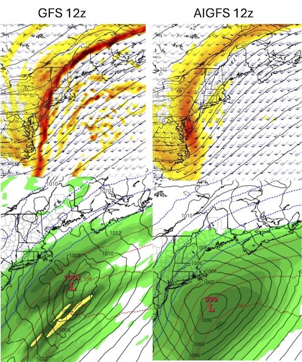
-
First Legit Storm Potential of the Season Upon Us
wxsniss replied to 40/70 Benchmark's topic in New England
Same. In case people missed it and are interested... below is a thread for general discussion on AI guidance beyond the Jan 18 storm: https://www.americanwx.com/bb/topic/62517-skynet-rise-of-the-forecast-machines-general-discussions-on-ai-guidance/ While I "do not have a lot of experience utilizing a lot of the AI guidance" (quoting Box AFD from this morning), some things I highlight in other thread relevant to Jan 18: • AI models tend to have broad QPF swaths that are overdone in areal coverage and not supported by physics • major weakness that is on display here: we have no idea why AI models do what they do... Why is AIGFS so robust here? Is it seeing something that physics models are not? Are the legacy models too sensitive to smaller features (e.g. the other day I suggested feedback between vorticity and convection sweeping off southeast coast hampering cyclogenesis), or is AI guidance not sensitive enough? If AI guidance changes, why did it change? Will that change be abrupt? These models are totally nebulous. Jan 18 is shaping up to be a great showdown.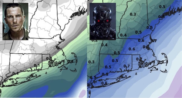
-
Most recently exemplified by this imminent showdown for Jan 18 where AI-GFS has been consistently and substantially more impactful than legacy GFS… …which is correct TBD... and because lots of people are interested in this topic, I thought I’d start a thread to encompass general debates, updates, and verification tally of AI vs. legacy non-AI / physics-based forecasting guidance. AI forecasting guidance has become operational and easily accessible in the past year. This feels like the first winter we are routinely considering these solutions. Some things this thread can encompass: • rolling tally of AI vs. non-AI performance • situations where AI does better / worse • news of model upgrades and rollouts • Ex Machina “You shouldn’t feel sorry for her. Feel sorry for yourself.” reflection: Do we want perfect AI guidance? So much of the joy in this hobby / profession is the suspense of uncertainty, dissecting vorticity and trends and pattern recognition, the thrill of the chase leading up to a storm that sometimes matches the actual storm. Will we lose this as AI improves? I summarized some relevant information here (yes, ironically with the help of ChatGPT). Major models today: • ECMWF AIFS (Artificial Intelligence Forecasting System) - Became operational early 2025, running alongside the traditional ECMWF - Supposed to be very fast and computationally cheap relative to ECMWF - Recently updated to incorporate “ physical consistency constraints through bounding layers, an updated training schedule, and an expanded set of variables”: https://arxiv.org/abs/2509.18994 • AIGFS (NOAA / experimental guidance) • GraphCast (Google DeepMind) - Claim skill competitive with global models at medium range: https://www.science.org/stoken/author-tokens/ST-1550/full) https://deepmind.google/blog/graphcast-ai-model-for-faster-and-more-accurate-global-weather-forecasting/ • FourCastNet (NVIDIA) https://build.nvidia.com/nvidia/fourcastnet/modelcard What’s driving the rollout? • Speed - AI global forecasts run in seconds to minutes, not hours • Cost & compute efficiency - Orders of magnitude cheaper than traditional NWP - Lower barrier for ensembles, re-runs, sensitivity testing • An arms race --- @Typhoon Tip articulated this nicely in the Jan 18 storm thread - ECMWF, NOAA, tech companies—everyone wants to be first (or not be left behind) • Decent skill at medium range - AI models are particularly strong at large-scale pattern evolution (trough/ridge placement, TC tracks, etc.) How have they performed so far? Strengths • Synoptic pattern recognition in mid-range, like days 3–7 • TC track forecasts • Consistency run-to-run (less chaotic noise) --- we’re seeing this already with AI-GFS / EC for the Jan 18 system Weaknesses 1) QPF magnitude and placement (especially winter storms, and Jan 18 threat might demonstrate this) • AI models often: - Smooth precipitation fields - Struggle with sharp gradients (e.g., coastal fronts, deformation bands) - Miss mesoscale enhancement tied to frontogenesis or CSI • They can produce: - Broad, confident-looking swaths that lack realistic structure --- we’re already seeing this with AI-GFS for Jan 18 - QPF maxima that are too spatially uniform • In winter storms, this shows up as: - Overdone areal coverage of moderate QPF --- again, see Jan 18 where this may be happening - Underrepresentation of narrow heavy bands - Difficulty separating rain/snow/ice impacts 2) Mesoscale & convective-scale processes: • AI models excel at large-scale pattern evolution, but:they do not explicitly resolve: - Convection initiation - Storm-scale feedbacks - Boundary interactions (outflows, lake effects, terrain-driven circulations) • As a result: - Severe weather ingredients can be misrepresented - Convective QPF tends to be overly smeared - Lake-effect and terrain-enhanced precipitation is inconsistent So, AI global models can look great at Day 5 synoptics but shaky inside Day 2–3 details. 3) Sensitivity to initial-condition uncertainty: AI models less good at knife-edge marginal setups where small differences have big impacts. 4) What’s behind the curtain is nebulous and not physically intuitive: When a physics model is wrong, you can often diagnose why (e.g. poor phasing, weak cold air damming, overmixed boundary layer) But with AI models: - Errors and biases can be systematic but reasons opaque - Forecasters will not know what to mentally discount This makes them harder to weigh or adjust the way we do with known biases (e.g. NAM is overamped, GFS southeast bias) 5) AI models are not optimized for rare events. They may overly weigh climatology and as a result miss extreme and rare events. What might we expect in the next few years? • Hybrid systems (physics + AI) becoming the norm • Continuous learning: Unlike traditional NWP (which evolves slowly via code and physics algorithm upgrades), AI models can be retrained frequently as new data become available, and incorporate recent busts or rare events more rapidly. Machine learning can incorporate more physics constraints and verification feedback. This theoretically allows self-correction and reduction in biases over time.
-
First Legit Storm Potential of the Season Upon Us
wxsniss replied to 40/70 Benchmark's topic in New England
EC a definite improvement though still a graze -
First Legit Storm Potential of the Season Upon Us
wxsniss replied to 40/70 Benchmark's topic in New England
0z EC AIFS ticked up, warnings to south shore Excellent trends at 0z so far -
First Legit Storm Potential of the Season Upon Us
wxsniss replied to 40/70 Benchmark's topic in New England
Just catching up... Holy AI GFS... 6z-12z-18z-0z today have been steady ticks to increase QPF in SNE... at H5 looks like it progressively downplays the lagging vorticity that shears out off the southeast coast. We get better tilt of the trough by 0z Monday. Will be a memorable GFS vs. AIGFS showdown. Can we rely on the age-old RGEM+AIGFS combo? -
First Legit Storm Potential of the Season Upon Us
wxsniss replied to 40/70 Benchmark's topic in New England
Increasingly interesting how these perform (at least as a distraction from a middling winter) 12z-18-0-6 GFS AI steadily ticked up each cycle 12z GFS AI stabilized / ticked back but would still be warning southeast SNE 12z EC AI has been fairly steady, advisory most of southeast SNE -
First Legit Storm Potential of the Season Upon Us
wxsniss replied to 40/70 Benchmark's topic in New England
You're right. I was proposing more the convection -> latent heat release -> amplified PV, so a feedback amplification of the remnant vorticity. But you'd expect that more downstream rather than upstream of the convection popping up. Anyway this is academic, not the biggest impediment to this system. -
First Legit Storm Potential of the Season Upon Us
wxsniss replied to 40/70 Benchmark's topic in New England
Probably both true... it is indeed remnant of a trailing S/W (circled in green below), but it also pulses off the southeast coast (green circle in 2nd frame) and I wonder if it's convection-related feedback... in any case, that might be interfering with more proficient cyclogenesis Variation of theme of too many chefs and lacking a discrete enough shortwave I don't think the 0z Euro or 6z models close this potential. AIs support advisory and probably what I'd favor at this point, but everything from a graze to warning in parts of SNE still realistic possibilities 84h out.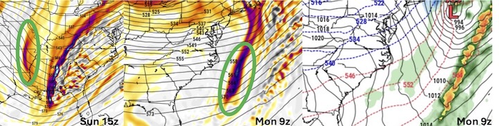
-
First Legit Storm Potential of the Season Upon Us
wxsniss replied to 40/70 Benchmark's topic in New England
Euro AI stable 12z-18z-0z, just outside BM, widespread advisory


