dendrite
-
Posts
73,513 -
Joined
Content Type
Profiles
Blogs
Forums
American Weather
Media Demo
Store
Gallery
Everything posted by dendrite
-
Was that generated by weathergeek?
-
It’s weird. The max/mins in nowdata are the same as this. The total precipitation is the same. The snow depth is the same. But the daily precip and snow numbers are slightly different.
-
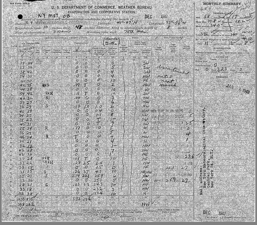
Where does the 26.4” in 1947 come from? The original COOP form has 25.8”
-
Probably near normal to date. But I probably average high 70s long term so maybe 12-18” away from normal.
-
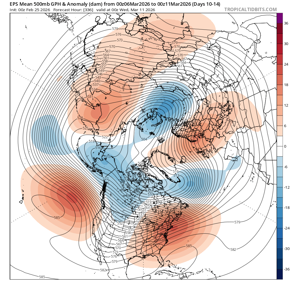
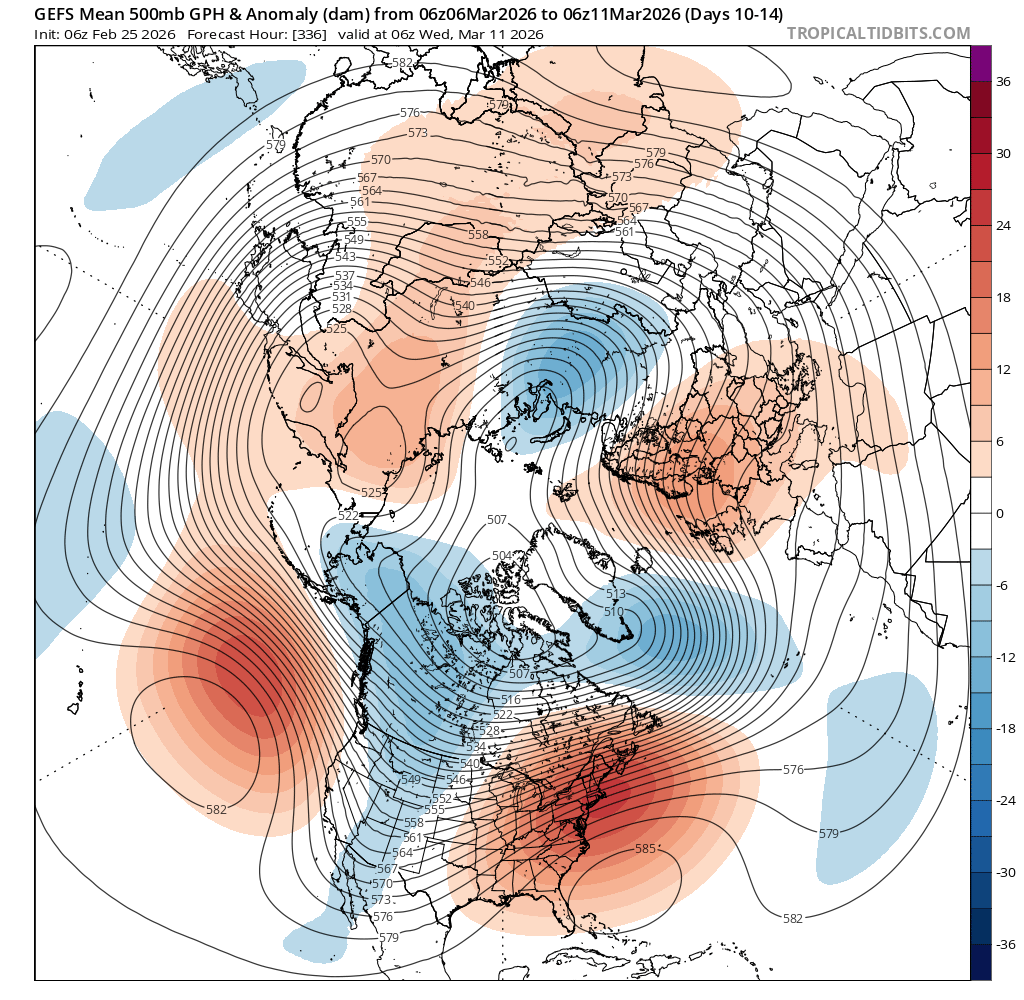
From 6z??
-
It sounds like he doesn’t need anymore snow
-
I find that difficult to believe given the visibility over those 3 hours. 18z 1/4sm 19z 1/4sm 20z 1 1/4sm 21z 2sm But it is what it is.
-
I think the accurate cocorahs guys are around 60”
-
At this point I think it’d be funny to finish BN while they crush it down there.
-

"Don’t do it" 2026 Blizzard obs, updates and pictures.
dendrite replied to Ginx snewx's topic in New England
I think I read in one of his comments that he saves them live and pieces them together. -
Clipper Fires In Wednesday Feb 25 Disco/ Obs
dendrite replied to Damage In Tolland's topic in New England
They claim there’s a penny shortage, but not up here. 0.9”/0.06” final -
"Don’t do it" 2026 Blizzard obs, updates and pictures.
dendrite replied to Ginx snewx's topic in New England
No idea. -
"Don’t do it" 2026 Blizzard obs, updates and pictures.
dendrite replied to Ginx snewx's topic in New England
Someday Wow will fix it -
Clipper Fires In Wednesday Feb 25 Disco/ Obs
dendrite replied to Damage In Tolland's topic in New England
There has to be an initialization issue right? Even the 3k completely lost it at 12.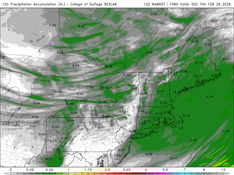
-
I had 142 2/3” in 07-08
-
Agree 100%. If we’re calling these models “guidance”…it definitely guided us along the correct path more than the others did. But I think it does matter come go time. I don’t put a lot of faith in most of the hires mesos (I think I made that clear the other day) so there was a point close in where the GFS was on an island compared to the other globals wrt NW extent. I was expecting it to meet consensus so it was no big deal to me, but for those believing it religiously on the northern edge got a bad surprise on 00z 23rd.
-
I get it…don’t take offense, but I think sometimes you get a little self centric. We all get boned. Any single one of us rarely jackpots. There’s this narrative that I steal big events up here, but I have 2 events where I’ve gotten 20” or more in the 20 years I’ve been here. 21” in Jan 11 and the 34” in Dec 20. Otherwise, I rack up the 10-15” type events. I asked you the other day how many 20”+ events you’ve had since EUSWX started. I’m going to guess more than 2 and I know you had that 30” burger where the NWS didn’t have you in the final PNS. I guess my point is that we would all have more if things trended more our way. Considering the BOS total and what S NH did, I don’t feel like you were that screwed. It was just the part of the gradient of the storm. Just my $0.02…not trying to instigate.
-
Clipper Fires In Wednesday Feb 25 Disco/ Obs
dendrite replied to Damage In Tolland's topic in New England
Yeah like that ^^^^^^ -
Clipper Fires In Wednesday Feb 25 Disco/ Obs
dendrite replied to Damage In Tolland's topic in New England
If it was rain down there he’d be posting multiple emojis. -
Clipper Fires In Wednesday Feb 25 Disco/ Obs
dendrite replied to Damage In Tolland's topic in New England
Dude is mehing because SoP is getting more -
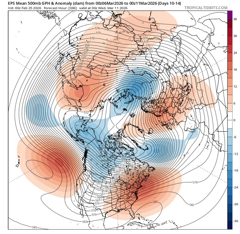
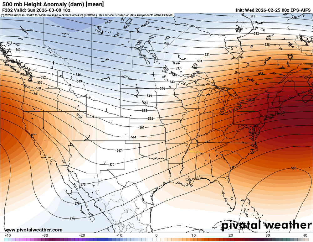
I think this one has more legs. Like Will said, it doesn’t necessarily mean tulips all of the time at the surface, but there’s probably going to be some big pack melt in one way or another.

-
Clipper Fires In Wednesday Feb 25 Disco/ Obs
dendrite replied to Damage In Tolland's topic in New England
Another overperforming S flow clipper down there. -
lol I think you’re beating me. Not sure what you mean by the last part though…you get what you get.
-
Sure. I think both of our posts are true. But it played major catch up the other day too. It was just consistently on the most northern side of guidance.
-
The GFS has done a good job at having the best idea from the medium range into the short range before making a little jump toward other guidance near go time.