

SACRUS
-
Posts
13,137 -
Joined
-
Last visited
Content Type
Profiles
Blogs
Forums
American Weather
Media Demo
Store
Gallery
Posts posted by SACRUS
-
-
Make me affirm that had we not been cloudy highs would have overperformed yesterday and will have the same potential today as we are seeing - minus seabreeze affected sites.
-
 1
1
-
-
91 / 74 here. In line with past upper 90s/low 100s
-
1
-
-
Hotter in NYC/EWR than Vegas these next 2-3 days
-
7 minutes ago, bluewave said:
The sample size for La Ninas reaching 102° and higher in June is very small. The only 2 years were 2021 and 2011. In 2021 when it reached 103° that was the high for the entire summer. But in 2011 the 102° in June was followed by 108° in late July.
in 2021 it did get into the upper 90s a few stretches in both July and August. EWR came just shy with 99 , 98's
-
Thurs is one of the days that will either be well below or way higher than projected for highs pending on the storms. Friday looks much a lock for onshore / cooler and cloudy day. Sat/Sun Flordiay style with sun hot quickly, weatch for storms.
-
89 here already and launching
clear so far.
-
Had posted last night that this ridge position and >594 DM is similar to Jul 18-19 2013 where all sites except the park got to 100. I think its closer to that , than last year's.
-
Both GFS/Euro maintain a warm and storm free 4th Mid 80s - low 90s area wide. Similar progressions - GFS a hair warmer. 276 hours out now.
2-3 : warm / humid mid 80s - low 90s
4th: warm / humid mid 80s - low 90s
5-6 : a bit wetter / storms possible -
Records:
Highs:
EWR: 99 (2024)
NYC: 96 (1888)
LGA: 99 (1988)
JFK: 94 (2010)
Lows:
EWR: 51 (1992)
NYC: 49 (1918)
LGA: 53 (1940)
JFK: 52 (1992)
Historical:1902 - The temperature at Volcano Springs, CA, soared to 129 degrees to set a June record for the U.S. (Sandra and TI Richard Sanders)
1944 - Four tornadoes killed 153 persons and caused five million dollars damage in Pennsylvania, West Virginia and Maryland. The tornadoes formed during the evening and moved southeast along parallel paths flattening everything in their way. The town of Shinnston WV was leveled, and was left with the majority of the causalities. Until that time it was believed that damaging tornadoes did not travel across mountainous terrain. (David Ludlum)
1944: The deadliest and strongest tornado in the state of West Virginia occurred on this day. The Shinnston Tornado that ravaged a path of destruction from Shinnston to Cheat Mountain, then on to Maryland and ending in Pennsylvania in the Allegheny Mountains, is the only twister to produce F4 damage in West Virginia. This tornado killed 103 people. Click HERE for more information from the History Channel.
1954: The temperature climbed to a high of 102 degrees setting a record for the date for Denver, CO. (Ref. Denver, CO Weather History)
1957 - A few miles west of Fort Stockton TX, softball size hail injured 21 persons unable to find shelter, mostly farm laborers. Some livestock were killed. (The Weather Channel)
1962: Lightning struck and injured a man near Buffalo, southwest of Denver, CO while he was riding in the back of a pick-up truck. He suffered multiple bruises...cuts...and shock. (Ref. Denver, CO Weather History)
1975: Hail up to 3/4 inch in diameter fell at Stapleton International Airport and over other parts of metro Denver, CO. Four funnel clouds were sighted: 10 miles northeast of Denver and south of Boulder and southeast of Boulder and south of Aurora. (Ref. Denver, CO Weather History)
1981: A thunderstorm produced wind gusts to 60 mph in Lttleton, CO. (Ref. Denver, CO Weather History)
1982: Two separate bolts of lightning injured three men in southwest Denver, CO and two buildings were also damaged. (Ref. Denver, CO Weather History)1987 - A massive hailstorm hit eastern Colorado causing an estimated 60 to 70 million dollars damage. At La Junta, CO, hail as large as softballs caused 37 million dollars damage. (Storm Data) (The National Weather Summary)
1988 - Thirty-four cities reported record high temperatures for the date. The reading of 90 degrees at Bluefield, WV, equalled their record for the month of June. The record high of 104 degrees at Billings, MT, was their thirteenth of the month. (The National Weather Summary)
1989 - Six cities in the High Plains Region reported record low temperatures for the date, including Sheridan, WY, with a reading of 38 degrees. Showers and thunderstorms in the eastern U.S. deluged New Castle County, DE, with 2.5 inches of rain in one hour. (The National Weather Summary)
1993: Non-convective high winds developed along the front range foothills near Denver, CO. Wind gusts to 70 mph were common near the foothills with numerous tree limbs broken by the winds. (Ref. Denver, CO Weather History)
1999: Hail as large as 1 inch in diameter was measured in the city of Denver, CO with 3/4 inch hail in Littleton, CO. (Ref. Denver, CO Weather History)2011: Damage shots from the Downers Grove EF-1 tornado Tuesday evening June 23, 2011 11:19 PM | An EF-1 tornado that went through the Downers Grove, Illinois during the evening west of the Chicago area. Greg states that the tornado began about 1 mile from his house in Woodridge, Illinois in the worst thunderstorm Chicago has had since August 2008. A weak EF1 tornado with 90-100mph winds was confirmed over Downers Grove. The tornado tracked literally right over Guy’s house where we have our poker nights every so often. Luckily his house was not damaged, unlike some of his neighbors.
2016: June 22-24. Part of a severe weather outbreak that produced over two dozen tornadoes from Illinois to West Virginia, up to 10 inches of rain fell in just 12-24 hours on June 23, setting off West Virginia's third deadliest flood. Twenty-three people lost their lives. -
37 minutes ago, Sundog said:
Do the people who are all gung ho for record heat and say they like it actually spend any appreciable time in it? Going from an air conditioned car to an air conditioned office to an air condirtioned home does not impress me.
Granted I think @LibertyBell actually enjoys suffering in heat if he sleeps in temps over 80 voluntarily. I'm not so sure about some other people.
I am let it be hot in the summer and let it snow Thanksgiving to St Pattys day kinda of old timer.
I do appreciate a dry heat / So Cal Palm Springs style . -
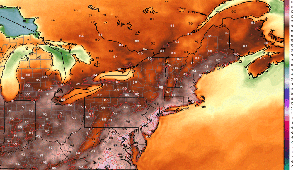
87 / 75 hot / humid and mainly clear. 72 hour (6/23 - 6/25) the heat - near or record heat this is, is on. Mid - upper 90s with some of the hottest spots getting to 100 today. Widerspread 100s minus any of the caveats of clouds and seabreeze. Could be 3 lows >80 in the metros. Wed its a race to see if storms/clouds arrive before the hottest spots get to the century mark. Clouds/showers could muddy up continuing the heatwave on Thu (6/26) before more prominent storms come through later thu into fri/ Friday clouds, showers and onshore keeps it in the 80s/ 70s.
The weekend looking to conitnue the trend with the threat of showers as the boundary linger near by, otherwise warm-hot / humid. Next week and leading up to the 4th - overall warm / humid and wetter. Ridge and heat building north and east towards the 7th.
6/23 - 6/25 : Strong Heat - upper 90s, 100s - lows >80
6/26: Hot/humid storms
6/27: Break in heat for all - clouds/showers
6/28 - 7/1: Warm-hot, humid - storms could keep it wet but period of sun (90s possible 1-2)
7/2 - beyond : Warm / humid - storms chances . Hotter towards the 6h/7th
-
10PM
EWR: 87
LGA: 87
NYC: 85
JFK: 85
New Brnswck: 82 -
Similar ridge position and forecasted 850 MB temps (100s)
Park of course missed , especially having come out of a very wet June
2013
7/18:
EWR: 101
LGA: 100
JFK: 100
NYC: 98
7/19:
EWR: 100
LGA: 100
NYC: 96
JFK: 95-
1
-
-
On a side note the ECMWF AI Ensembles package will launch July
https://events.ecmwf.int/event/487/
On Tuesday 1 July 2025, the first version of the Artificial Intelligence Forecasting System (AIFS) Ensemble model will be released and supported operationally. This release marks another milestone in ECMWF history, as AIFS ENS v1 will be the first AIFS ensemble model to be made fully operational.
AIFS ENS, v1 model will not be an upgrade of currently experimental diffusion AIFS ENS model. It is a first version of a new model that is trained using a version of the Continuous Ranked Probability Score (CRPS), a loss function that helps ensure the forecasts are both accurate and well-calibrated.
In addition to operationalisation of AIFS ENS, v1 will bring several new data and graphical probabilistic prodcuts available in the EMCWF Open charts platform.
-
1
-
-
4 minutes ago, Sundog said:
Can someone post the 18z Euro's highs for Tuesday?
Looks like 105 in NYC / NE-NJ NYC/NJ metro
-
 2
2
-
-
9PM
LGA: 88
EWR: 88
NYC: 85
JFK: 84
New Brnswck: 83 -
Still 85 / 73 here nice lifting board for tomorrow.
-
Similar placed ridge at 500MB to Jul 17-18 2013 which produced 100 degree heat.


-
2
-
-
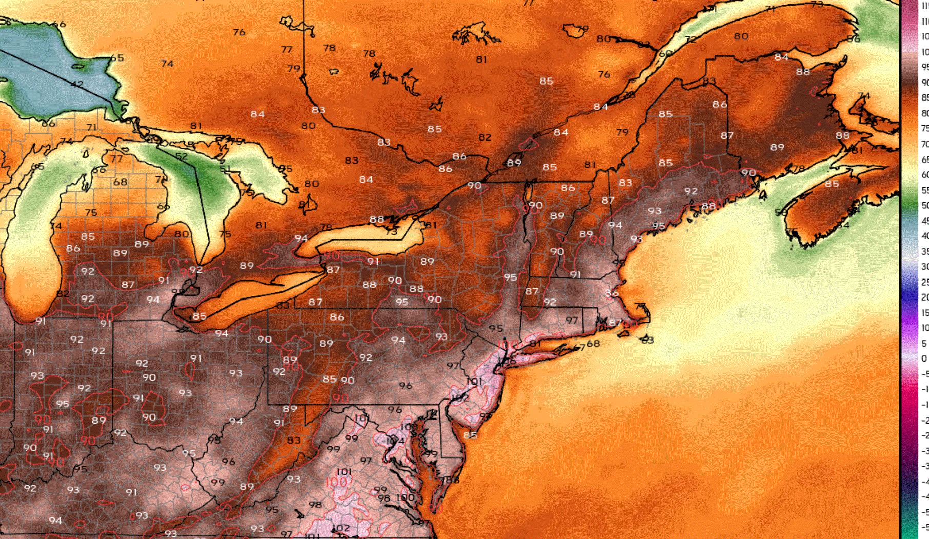
Both the GFS and Euro maintain a warm-hot and steamy day on the 4th low 90s metro, upper 80s coast beaches with no rain.
2-3 : warm / humid
5-6 : warm humid storms on the euro on the 6th -
What is left of the MCS and clouds still seen of the last few loops riding around the rim of the expanding ridge

-
Clouds through 4PM and still made it to 90 here, in most placed even with almost a full day of clouds forecasts highs were only missed by 6 - 8 degrees. Had we partly cloudy/ sunny conditions - highs would have over performed in my opinion.
-
On 4/26/2011 at 9:17 AM, SACRUS said:
2025:PHL: 3 (Apr: ; May: ; Jun: 3 ; Jul: ; Aug: ; Sep: )
EWR: 5 (Apr: ; May: ; Jun: 5 ; Jul: ; Aug: ; Sep: )
TTN: 1 (Apr: ; May: ; Jun: 1 ; Jul: ; Aug: ; Sep: )
LGA: 3 (Apr: ; May: ; Jun: 3; Jul : ; Aug: ; Sep: )
ACY: 4 (Apr: ; May: ; Jun: 4 ; Jul: ; Aug: ; Sep: )
TEB: 5 (Apr: ; May: ; Jun : 5 ; Jul: ; Aug: ; Sep: )
NYC: (Apr: ; May: ; Jun: ; Jul: ; Aug: ; Sep: )
JFK: 2 (Apr: ; May: ; Jun: 2; Jul: ; Aug: ; Sep: )
ISP: 1 (Apr: ; May: ; Jun: 1 ; Jul: ; Aug: ; Sep: )New Brunswick: 2 (Apr: ; May: ; Jun: 2 ; Jul: ; Aug: ; Sep: )
BLM: 2 (Apr: ; May: ; Jun: 2 ; Jul: ; Aug: ; Sep: )89 Degree Days:
New Brnswck: 2
TTN: 1
TEB: 1
BLM: 1
------------------------------------------------------------------------------------------------------------------------------------------------------------------------------------------
Clouds spoiled a clean sweep but late in the day comeback almost got all stations there.
EWR: 92
ISP: 91
JFK: 91
TEB: 91
LGA: 90
ACY: 90
New Brnswck: 88
BLM: 88
NYC: 88
PHL: 88
TTN: 87-
1
-
-
Highs
Clouds in the way for most of the day with a decent comeback later in the PMEWR: 92
ISP: 91
JFK: 91
TEB: 91
LGA: 90
ACY: 90
New Brnswck: 88
BLM: 88
NYC: 88
PHL: 88
TTN: 87-
1
-
-
Amazing it just has such a tendency to be cloudy of late, clouds clinging - so hard to clear out
-
1
-
June 2025 discussion-obs: Summerlike
in New York City Metro
Posted
Again the issue more with central park is its used for the center / mecca of NYC weather when reporting. So for example today's the first 90 degree day in NYC when in fact there have been between 2 - 4 already. First 100 degree day in 13 years when there have been more recently in NYC/NJ metro proper. Perception.