

SACRUS
-
Posts
13,163 -
Joined
-
Last visited
Content Type
Profiles
Blogs
Forums
American Weather
Media Demo
Store
Gallery
Posts posted by SACRUS
-
-
See if something minimal pops over FL

-
92 / 68
-
 1
1
-
-
7/5 - 7/9 : stronger heat potential with some cooler candian air to the north. Heat could be focused mainly to the south of us persistently, but spikes look to come north at times.
-
1
-
-
Overall the same but slight wrinkle Wed Pm - the thu fourth AM
7/2 - 7/3: Warm - hot , humid - 80s - low 90s, storms potential Wed evening/Thu early
7/4 : any storms clear by the early morning, clears out - dry 79s - 80s
7/5 - 7/6 : Warm - hot, humid, stronger heat possible by the weekend, storms possible -
Records:
Highs:
EWR: 102 (2021)
NYC: 101 (1934)
LGA: 98 (2021)
JFK: 99 (1959)
Lows:
EWR: 56 (1968)
NYC: 52 (1919)
LGA: 59 (1995)
JFK: 55 (1995)
Historical:1826: Thomas Jefferson made his last entry in his weather observation log on this date, just six days before he died. The weather held a fascination for Jefferson as he made regular weather observations. He bought his first thermometer while working on the Declaration of Independence and his first barometer shortly after that.
1878: The weather observer on top of Colorado's Pike's Peak noticed that a major storm remained stationary over South Park, some 50 miles away. The observer also noted that the whitened ground from hail could be seen until sunset. (Ref. Wilson Wx. History)
1899: A great flood occurred on the Brazos River in Texas. The flood waters reached a width of 12 miles and caused $10 million dollars in damage. (Ref. Wilson Wx. History)
1907: A tropical storm moved from the Gulf of Mexico to coastal North Carolina, where it dissipated. The remnants moved north and combined with a cold front moving in from the Ohio valley, producing two days of widespread severe weather through the 29th. In some areas, rainfall amounts ranged from 3 to 6.73 inches, producing flooding that exceeded the flooding of tropical storm Agnes in 1972. Thunderstorms also produced high winds, hail and tornadoes, including F2 tornadoes at Edgemont, PA where debris from a destroyed garage was carried three-quarters of a mile away. Eight people were killed, six by drowning in swollen streams or rivers.(Ref. Wilson Wx. History)
1931 - The temperature at Monticello FL hit 109 degrees to establish an all-time record for the state. (The Weather Channel)
1943" Minimum temperatures were above 75° from 23rd to 28th in Washington, DC and greater than 70°F on June 20th-29th. (Ref. Washington Weather Records - KDCA)
1954 - Hurricane Alice dumped as much as 27 inches of rain on the Lower Rio Grande Valley of Texas. The Rio Grande River at Laredo reached a level 12.6 feet above its previous highest mark, and the roadway of the U.S. 90 bridge was thirty feet below the high water. (David Ludlum)
1962: Flooding in Wichita Falls, TX resulted in a quarter million dollar loss in city equipment, man hours, and other city property. The official rainfall total at Sheppard Air Force Base was only 1.64 inches, but other reported rainfall included 2.60 inches in downtown Wichita Falls, and from 4.20 to over 5 inches at Charlie, in northern Clay County. An estimated 300 cars were stranded temporarily on highway 287 near Jolly, when sections of the highway were flooded by over two feet of water. (Ref. Wilson Wx. History)
1975: Near Kingsland, Ark.--Lightning struck and killed a 6-year-old and injured her aunt while they were on a family outing on the banks of the Saline River. (Ref. Lightning-The Underrated Killer.pdf)1987 - Thunderstorms produced severe weather in the Ohio Valley and the Great Lakes Region, with reports of large hail and damaging winds most numerous in Ohio, Indiana and Michigan. Thunderstorms spawned four tornadoes in Michigan. A tornado near Clare MI was accompanied by softball size hail. In Colorado, an untimely winter-like storm blanketed Mount Evans with six inches of snow. (The National Weather Summary) (Storm Data)
1988 - Alpena, MI, reported a record low of 39 degrees while Jackson, MS, equalled their record for the month of June with an afternoon high of 105 degrees. Thunderstorms in the central U.S. soaked Springfield MO with 3.62 inches of rain, a record for the date. (The National Weather Summary)
1989 - Thunderstorms produced severe weather in the Southern and Central High Plains Region. Thunderstorms in Colorado produced softball size hail at Kit Carson, while pea to marble size hail caused ten million dollars damage to crops in Philips County, CO. (The National Weather Summary) (Storm Data)
1990: A microburst wind estimated around 150 mph did extensive damage in the town of Streamwood, in the Chicago metro area in Illinois. At least $10 million dollars damage was done to 25 stores and industrial buildings. Radar and eyewitness accounts indicated no rain or thunderstorms in the immediate vicinity of the area at the time. (Ref. Wilson Wx. History)
1993: Flash flooding rolled across southeast South Dakota and into northwest Iowa. A phenomenal 6 to 7 inches of rain fell in Dickinson and Emmett Counties during a 3 to 4 hour period. The Des Moines River rose several feet in just a few hours. Ocheyedan received 3 inches in just 45 minutes and Allendorf picked up 2.80 inches in 30 minutes. Many locations in northwest Iowa reported winds in excess of 60 mph, with some locations clocking speeds of 70 to 80 mph. Several tornadoes were also spawned during the evening in Emmett County in the Ringsted area, 3.50 inch hail fell and baseball size hail covered the ground just north of Estherville. Millions of dollars in damage was caused from the thunderstorms across the area.1993: No river traffic was moving on the 585 miles of the Mississippi River from St. Paul, MN to Cairo, IL and on 535 miles of the Missouri River from Sioux City, IA to the point it joined the Mighty Mississippi. More than 5, 000 loaded barges were stranded. For the first time in history, major floods came down both rivers at the same time. (Ref. Wilson Wx. History)
1994: Persistent extreme heat in the Southwest as Arizona 128°F at Lake Havasu City and Nevada 125°F at Laughlin set all-time record high temperatures on the same date. (Ref. Lowest and Highest Temperatures for the 50 States)
1998: "The Corn Belt Derecho of 1998" in the following states NE, IA, IL, IN, KY. A derecho which originated in far southeast South Dakota moved across Illinois during the afternoon and evening and continued as far east as Ohio the next morning. Every county in central Illinois sustained some damage, as these severe thunderstorms passed. Winds gusted in the 60 to 80 mph range, with some localized microbursts producing winds more than 100 mph. Significant damage occurred in the microburst areas, including the towns of Morton, McLean, LeRoy, and Tolono. In Tolono, 22 cars of a southbound 101-car Illinois Central freight train were blown off the tracks. It was unknown how many vehicles were picked up by the wind, but 16 cars were turned over, and another six derailed but remained upright. The train was en route to Centralia from Chicago with a load of mixed freight, including plastic pellets and meal. The freight cars empty weighed about 60,000 pounds, while a full one weighs about 260,000 pounds. Overall, 12 people were injured, and damage was estimated at around $16 million.
2003: Tropical Storm Bill made landfall south of Houma, LA with top winds of 60 mph, spreading a six foot storm surge across the low lying portions of the Louisiana Coast. For the second time in two years, the town of Montegut, LA was flooded after the town’s protection levee was breeched. Bill dumped 5 to 8 inches from Louisiana to Alabama. A tornado at Reserve, LA injured four people.
(Ref. Wilson Wx. History)
2005: Heavy rains of 3 to 7 inches fell across far eastern Brown, western and northern Day, and most of Marshall Counties in South Dakota during the early morning and again in the afternoon hours. One location measured 5 inches of rain in two hours. In Day County, 30 roads were washed out and 15 bridges were damaged. Some rainfall amounts include 5.04 inches in Britton, 3.34 inches north of Columbia, and 2.08 inches at Aberdeen. Total June rainfall for some locations in Marshall and Day Counties was between 11 and 12 inches. The flooding continued into early July before receding by July 10th. (Ref. Wilson Wx. History)
2012: The maximum temperature today was 103 °F at the Richmond International Airport a new record maximum temperature for the date. The old record was 101 °F in 1980. (Records since 1897) The maximum at the West Henrico Co. - Glen Allen station was 102 °F at 4:20 PM. It was the hottest day here since July 22, 2011 when it was also 102 °F. Friday's derecho, a widespread and long-lived violent thunderstorm complex, affected millions of people from Chicago, Ill., to Washington, DC. Strong winds, in many cases in excess of 70 mph, downed numerous trees and power lines from Illinois to Maryland. Over 2 million people were left without power. Winds with derecho -- 86 mph at Wintergreen Mt., 80 mph at Roanoke Airport 71 mph, Dulles 70 mph at Reagan, National 59 mph in Richmond International Airport and only 37 mph in West Henrico Co. - Glen Allen VA. (Ref. Derecho Hits Ohio Valley, VA, MD See Map
(Ref. Violent Storms Virginia, Maryland, D.C (Ref. Derecho Damage- 32 pages Worth of Damage Reports
2012: Fifth of the top ten weather events - Mid-Atlantic and Midwest Derecho. June 29. The widespread severe winds associated with the band of rapidly moving thunderstorms (a derecho) left a trail of destruction from Illinois to the mid-Atlantic, leaving some 4.25 million homes and businesses without power, killing 24 people, and costing hundreds of millions of dollars in property-
2
-
-
81 / 73 sunny. Race to any clouds / storms popping, otherwise Florida style heat today upper 80s / low 90s. Sam for Monday and Tuesday with storms perhaps more widespread into later mon evening and Tue, hot /humid both days upper 80s / low 90s in the hotter spots.
Wed the GFS and Euro now drive a mcs within the trough that looks to bring storms Wed evening into the early morning of the fourth but looks to clear. Other runs had this into New England but perhaps a speedier version to last Sunday with any storms/rain in / out to make way for a gorgeous (drier/cooler) fourth upper 70s - 80s.
By next weekend heat and humidity building back north and east and it looks like spikes of heat by the 7th - 10th with cooler canadian air nearby by and the sauna below, looks overall warm - hot but some moderation between spikes of stronger heat.
6/29 - 7/3 : Hot / Humid - storms potential focus on Sun PM - Tue - Wed night
7/4 : Any storms clear out, gorgeous dry/ warm 70s - 80s
7/5 - 7/6 : Warm / Hot - humid - heat building back
7/7 - 7/10 : Hotter
7/11 - Beyond - Warm - hot , interludes of strong heat, moderation (caught between canadian cool / sauna)

-
1
-
 1
1
-
-
Highs:ACY: 91
EWR: 89
PHL: 88
New Brnswck: 87
TTN: 86
YEB: 86
BLM: 85
LGA: 85
NYC: 83
JFK: 82
ISP: 82-
1
-
-
Hope these fizzle (CPA) otherwise about 3 - 6 hours for arrival if, assuming nothing else pops.
-
83 / 71 here
Partly cloudy
-
78 / 71 partly cloudy ish now
-
Onshore has ceased a. 74 / 69 brightening skies
-
1 hour ago, LibertyBell said:
There is no perceptible difference between 98, 99 and 100 degrees. So if it's going to be 98-99 it might as well be 100. 105+ etc isn't necessary.
If we were a metric country we'd have our 32.2C days and 37.7 C days
-
1
-
-
70 / 69 , stingy clouds helding on.
-
1
-
-
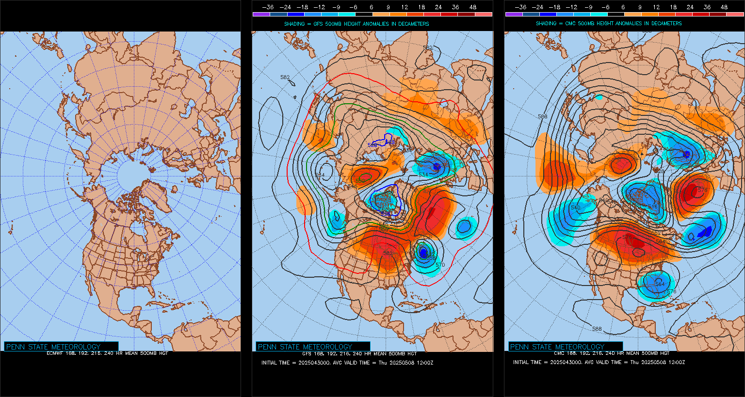
Euro still not updating in the PSU site but is between the GFS/Candn . Ridge off tne PNW forcing trough down the rockies.
-
Mainly Dry - only light isolated showers in CPA and scattered showers /offhsore ELI
-
Both runs Fri and today looking similar
7/2 - 7/3 : Warm- hot humid - mainly dry highs upper 80s/ low 90s
7/4: Dry - warm 80s - clear _ euro coolest near 80
7/5 - 7/6 : Warm - hot - humid , scattered storms.-
1
-
-
Records:
Highs:
EWR: 99 (2021)
NYC: 96 (1991)
LGA: 96 (2021)
JFK: 98 (2010)
Lows:
EWR: 53 (1970)
NYC: 54 (1995)
LGA: 55 (1995)
JFK: 54 (1995)
Historical:1788 - The Battle of Monmouth in central New Jersey was fought in sweltering heat. The temperature was 96 degrees in the shade, and there were more casualties from the heat than from bullets. (David Ludlum)
1865: 24 people were killed by a tornado which cut a 40 mile swath through Southwest Wisconsin. (Ref. Wilson Wx. History)
1892 - The temperature at Orogrande UT soared to 116 degrees to establish a record for the state. (Sandra and TI Richard Sanders)
1923 - A massive tornado hit Sandusky, OH, then swept across Lake Erie to strike the town of Lorain. The tornado killed 86 persons and caused twelve million dollars damage. The tornado outbreak that day was the worst of record for the state of Ohio up til that time. (David Ludlum)
1924: An F4 tornado hit Sandusky, OH then moved eastward across Lake Erie to strike Lorain, OH. 15 of the 64 deaths at Lorain occurred in the State Theatre, where a silent film was being shown. The tune "Sacrifice" was being played on the piano when the twister struck. The tornado produced a massive wave on Lake Erie. 85 people were killed and total damage was $12.5 million dollars (Ref. Wilson Wx. History)
1952: The highest overnight minimum temperature was 82° with a 98° maximum gave a daily mean of 90° at National Airport.
1954: All-time record temperatures for South Carolina tied at Camden, SC: 111 °F. (Ref. Lowest and Highest Temperatures for the 50 States)1975 - Lee Trevino and two other golfers are struck by lightning at the Western Open golf tournament in Oak Brook, IL. (The Weather Channel)
1980 - The temperature at Wichita Falls, TX, soared to 117 degrees, their hottest reading of record. Daily highs were 110 degrees or above between the 24th of June and the 3rd of July. (The Weather Channel)
1987 - Thunderstorms developing along a cold front produced severe weather in the north central U.S. Thunderstorms in Nebraska produced wind gusts to 70 mph and baseball size hail at Arapahoe, and wind gusts to 80 mph along with baseball size hail at Wolback and Belgrade. Six cities in the Ohio Valley reported record low temperatures for the date, including Cincinnati, OH, with a reading of 50 degrees. (The National Weather Summary) (Storm Data)
1988 - Showers and thunderstorms brought much needed rains to parts of the central U.S. Madison, WI, received 1.67 inches of rain, a record for the date, and their first measurable rain since the Mother's Day tornado outbreak on the 8th of May. (The National Weather Summary)
1989 - Evening thunderstorms deluged Winnfield LA with eleven inches of rain in four hours and fifteen minutes, and Baton Rouge LA reported 11 inches of rain in two days. Totals in west central Louisiana ranged up to 17 inches. Thunderstorms produced severe weather in the Northern High Plains. Two inch hail broke windows in nearly every building at Comstock, NE. Thunderstorms in North Dakta produced two inch hail at Killdeer, and golf ball size hail at Zap. (The National Weather Summary) (Storm Data)
1998: Record breaking heat occurred across parts of the southern Plains. Amarillo, TX (recently broken, currently 6/26/2011: 111°) and Dodge City, KS both set their all-time record high temperatures with 108° and 110° respectively. Roswell, NM recorded a record daily high of 110 °F. (Ref. Wilson Wx. History)
2003: A damaging severe thunderstorm rolled in from the east into Liberal, KS. The combination of 80 to 100 mph wind and hail larger than golf balls produced at least $8 million dollars in damage. Flash flooding occurred following the devastating hail and wind storm. Nearly all streets in and around Liberal were flooded. (Ref. Wilson Wx. History)
2006: The storm total of the 22nd - 28th of 2006 was 12.10 inches the most precipitation ever recorded at the Annandale Weather Center in a storm in the last 26 years; the old storm total record was October 6th - 8th of 2005 when 7.09 inches occurred.
We were lucky in a sense that 2006 was dry with a - 6.29 precipitation departure going into June or even more flooding would have been experienced. (Annandale Weather Center - Annandale, VA.)
2010: The maximum temperature today at the Richmond International Airport was 102 °F which not only broke the record high temperature for the date, but was close to the 104 °F record maximum for the month of June. Both June 27th and 28th had a maximum temperature 102 °F. Richmond has never had back to back 100 °F plus days before in June. Only three June days have been hotter: (June 30, 1937 103 °F) (June 19, 1944 103 °F) (June 26, 1952 104 °F ) June 2010 also had 19 days of 90 °F or hotter temperatures the record was 20 in 1943. The Richmond International Airport reported the mean temperature for June was 81.1 °F which was a new 113 year record. This breaks the old record of 79.2 °F set in 1943 and was a +8.7 °F departure from average. June had 8 new daily temperature records and all were for heat. (Ref. Richmond Weather Records - KRIC)2010: Richmond, Virginia, set record for the most days in June reaching 102 degrees F (June 24, 27, and 28). (Ref. Weatherwise U.S. Weather Highlights of 2010 page 8 )
-
1
-
-
67 / 65 still an onshore focus keeping the June gloom cloud magnet overhead the brunt of the morning into early afternoon. Once the sun returns heats up quickly to the mid / uppper 80s. Those with more prolonged periods of sun could touch 90. Scattered storms overnight. Sunnier Sunday heats up upper 80s to low 90s in the hot spots again with scattered storms overnight.
Mon looks the hottest of the week (till the 6/7th) with enough sun ahead of any storms, low perhaps some mid 90s in the hot spots. Tue storms may be abit more in coverage, otherwise hot/humid with in/out sun.
Wed - Sat : Looks like a nice stretch (perhaps the nicest) of the summer beach days , dry, sunny, warm mainly mid - upper 80s with a mainly clear and dry fourth of July. Euro is coolest for the 4th/5th keeping the area low 80s or lower. Beyond there hotter towards the 7th and we'll see how the ridge lines up , overall hotter.
6/28 - 7/1 : Hot/humid possible storms (focus Sat PM, Mon PM / Tue)
7/2 - 7/5 : Warm, dry , clear mainly 80s
7/6 - 7/7: maybe a bit wetter
7/7 - beyond : Turning Hotter
-
2
-
-
1 hour ago, LibertyBell said:
I wonder if the cool downs in 1953 were similar to the one we are in right now? It did have two super heatwaves (heatwaves of 7+ days) and that all time record 12 day super heatwave that culminated in the all time September record of 102 and 4 days of 100+ evenly split between the two super heatwaves which was only matched in 1966 (which had 4 100+ days split between three heatwaves.)
I attached the readings in the post above as a pdf for EWR. Similar coold downs for sure and lower minimums in 1953
-
1
-
-
30 minutes ago, LibertyBell said:
after mid July it's fair game because we'll have enough time to reload-- see the summers of 1953, 1966 and 1983 as prime examples of summers with multiple 100+ degree heatwaves.
'66 was a mid Jun - mid July focused heat summer,
1983 was hot throughout Jun-Jul-Aug / early Sep,1
953 was similar but had share of cooldowns culminating in the record torch late Aug-early September heat.-
1
-
-
Just now, bluewave said:
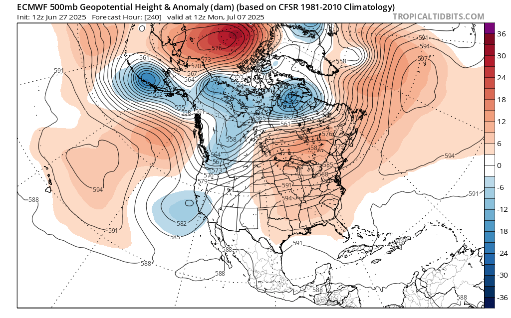
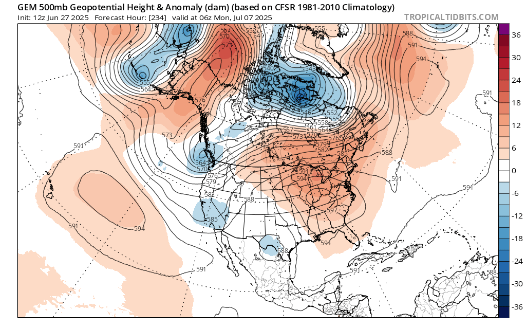
Unfortunately, the 12z guidance wants to reload another 594+ ridge in about 10 days. I was hoping we could get a break from the 100° heat. But it looks like the pattern may have other ideas. Past instances of 103° to 105° heat didn’t usually have such a quick follow up of the ridge rebuilding. So maybe we can keep it more in the 95° to 100° range in early July rather than pushing 105° again. But who knows for sure with this climate.

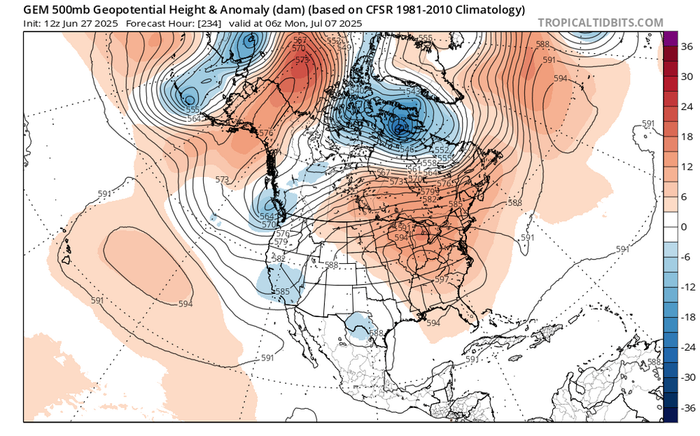
The Euro op has 600 DM ridge center in MO/KS at H 288
-
1
-
 1
1
-
-
High so far here is 69
-
3 minutes ago, forkyfork said:
i grew up in bayonne and a huge storm in the early/mid 90s is what got me into wx. it might be this one
2.05 inches of rain between the 29- 30 , 1994 at EWR
-
1
-
-
July 4th weather
in New York City Metro
Posted
12z simlar with 3rd storms potential ands a gorgeous 4th. GFS hotter for the weekend