

SACRUS
-
Posts
16,204 -
Joined
-
Last visited
Content Type
Profiles
Blogs
Forums
American Weather
Media Demo
Store
Gallery
Posts posted by SACRUS
-
-
Records:
Highs:
EWR: 103 (2011)
NYC: 104 (1977)
LGA: 100 (2019)
JFK: 99 (2019)
Lows:
EWR: 56 (1951)
NYC: 55 (1890)
LGA: 62 (1974)
JFK: 58 (1965)
Historical:
1911 - The temperature at Painter, WY, dipped to 10 degrees to equal the record low for July for the continental U.S. (The Weather Channel)
1930: The state record for Delaware was established that day with a reading of 110 °F at Millsboro, Delaware. (Ref. Lowest and Highest Temperatures for the 50 States)1934 - The temperature reached 109 degrees at Cincinnati, OH, to cap their hottest summer of record. The state record for Ohio was established that day with a reading of 113 degrees near the town of Gallipolis. (David Ludlum)
1939: Richmond, Virginia had a high temperature for the day of 65 °F making it the coolest July day on record (records since 1897). (Ref. Richmond Weather Records)
1942: This is the only occurrence Miami, FL has ever seen 100°. (Extreme Weather p. 273, by Christopher C. Burt)
1947: Holt, MO records world record 12 inches of rain in only 42 minutes.(Ref. Wilson Wx. History)1975 - Six inches of rain fell across Mercer County, NJ, in just ten hours causing the worst flooding in twenty years. Assunpink Creek crested eleven feet above flood stage at Hamilton and Trenton, the highest level of record. Traffic was brought to a standstill, and railway service between New York City and Washington D.C. was cut off for two days. Flooding left 1000 persons homeless, and caused an estimated 25 million dollars damage. (David Ludlum)
1979: Parts of Lancaster County into the west central Chester County, Pennsylvania region was hit with torrential rain during the morning, with most of the rain falling in about 5 hours. In Chester County, Newlinville received 8.11 inches and Valley Township 7.56 inches. (Ref. Wilson Wx. History)
1986: A tremendous heat wave continued across the South. This was the 15th day in a row with 100° plus degree readings at Columbia, SC. Macon, GA topped out at 106 °F. It was also the 10th consecutive day with 100° degree plus heat at Macon. (Extreme Weather p. 273, by Christopher C. Burt) (Ref. Wilson Wx. History)
1987 - Thunderstorms produced severe weather from Utah to North Dakota, spawning a dozen tornadoes in North Dakota. Thunderstorms in North Dakota also produced baseball size hail at Clifford which caused four million dollars damage, and high winds which toppled a couple of eighty foot towers cutting off power to the town of Blanchard. (The National Weather Summary) (Storm Data)
1988 - While cool air invaded the central U.S., unseasonably hot weather continued over the western states. The temperature at Spring Valley, NV, soared from a morning low of 35 degrees to an afternoon high of 95 degrees. Fallon, NV, reported an all-time record high of 108 degrees, and Death Valley, CA, reported their sixth straight day of 120 degree heat. (The Weather Channel) (The National Weather Summary)
1989 - Afternoon thunderstorms over Florida produced wind gusts to 92 mph at Jacksonville, damaging thirteen light planes at Herlong Field. Five cities in Texas reported record low temperatures for the date. Corpus Christi, TX, equalled their record low for the date with a reading of 71 degrees, and then tied their record high for the date that afternoon with a reading of 97 degrees. (The National Weather Summary) (Storm Data)
1991: Boston, MA recorded 81 °F for the warmest low temperature. 100 degree readings are not common in Rhode Island, but the mercury topped out at 102° at Providence on this day, the second day in a row that the thermometer reached the century mark. (Ref. NOAA Boston Weather Events)
1993: The Mississippi River crested at 46.9 feet at St. Louis, MO, easily breaking the old record of 43.2 feet established in the 1973 flood. The 11 mile long, 52 foot high flood wall kept water out of the city center. In spite of all the damage the flood did, it is estimated that without all of the flood-control measures in place today, the price tag from the flood would have easily doubled its astronomical $20 billion total. The record crest would be topped again on August 1st. The heavy rainfall that occurred earlier in the month set the stage for what became the flood of the century in Iowa. The city of Des Moines was very hard hit. At the peak of the flooding, nearly 35,000 households were without electricity and 50,000 were without power. Water service was out for 250,000 people, which is the largest water outage in United States history. Losses to the businesses in Des Moines were estimated at $800 million dollars, from physical damage to the buildings and lost business. Other damage in Des Moines included $30 million dollars to homes, $75 million dollars to the levee system and $20 million dollars to the water treatment plant. Damage to West Des Moines was also well over $30 million dollars. Crop damage was extensive as 6.5 million acres of cropland were damaged by the flood. (Ref. Wilson Wx. History)
1995: A camper at Colonial Beach in Westmoreland County, VA took refuge under a tree during a thunderstorm. The tree was struck by lightning, which in turn caused second degree burns over 20 percent of the camper's body. (Ref. Lightning - Virginia Weather History)
1997: Extreme flooding occurred over Baldwin County, Alabama as the remnants of Hurricane Danny drifted slowly northeastward after dumping 30 inches of rain over coastal Alabama. The worst flooding occurred around the Fish River where 500 homes were damaged. (Ref. Wilson Wx. History)
1999: The Cedar River in Charles City, IA reached its all-time crest of an estimated 22.8 feet. Approximately 100 homes had flood damage in Charles City. Almost 12 inches of rain fell in a 48 hours period over these counties. Rainfall totals that day: New Hampton, IA: 7.10 inches (wettest day on record), Charles City, IA: 6.65 inches, West Union, IA: 4 inches. (Ref. Wilson Wx. History)
2006: Western Washington: An unusual heat wave in western Washington breaks five maximum temperature records: Vancouver at 104°F, Olympia at 100°F, Seattle at 97°F, and Hoquiam at 90°F. (Ref. WxDoctor)
2011: at 4:50 PM Chicago bakes in first back-to-back 100-degree days in 16 years since deadly heat wave in July 1995 The mercury hit 101 degrees at Midway Airport at 4:40 pm Thursday afternoon marking the second straight day of triple-digit heat there. This was the city's first encounter with back- to-back 100-degree days in 16 years since the deadly heat wave of July 1995. Back then the mercury soared to 106 degrees on July 13 and was followed by a 102 degree high on July 14. The city's official site at O'Hare Airport has fallen just short of triple-digit heat for the second straight day. Today official high there was 99 degrees recorded at 1:58 pm. On Wednesday the 20th the city's official high at O'Hare international Airport was also 99 degrees. (Ref. WGN Chicago Weather Center - Tom Skilling) -
76 / 60 and much more humid air moves in on the southerly flow ahead of the front. Storms / rain into northern areas and some clearing working east out of PA to potentially heat things up for some unstable triggers later. Still think we have clouds and showers lingering a bit tomorrow before clearing out. Overall below normal 7/23 - 7/29 and with the trough in place id look for more unforeseen storms / rain chances early next week Monday. Beyond there western ridge builds heat and the atlantic ridge is building wst. 7/30 - beyond moderation to a warmer/ humid and next shot at heat potential.
-
 1
1
-
-
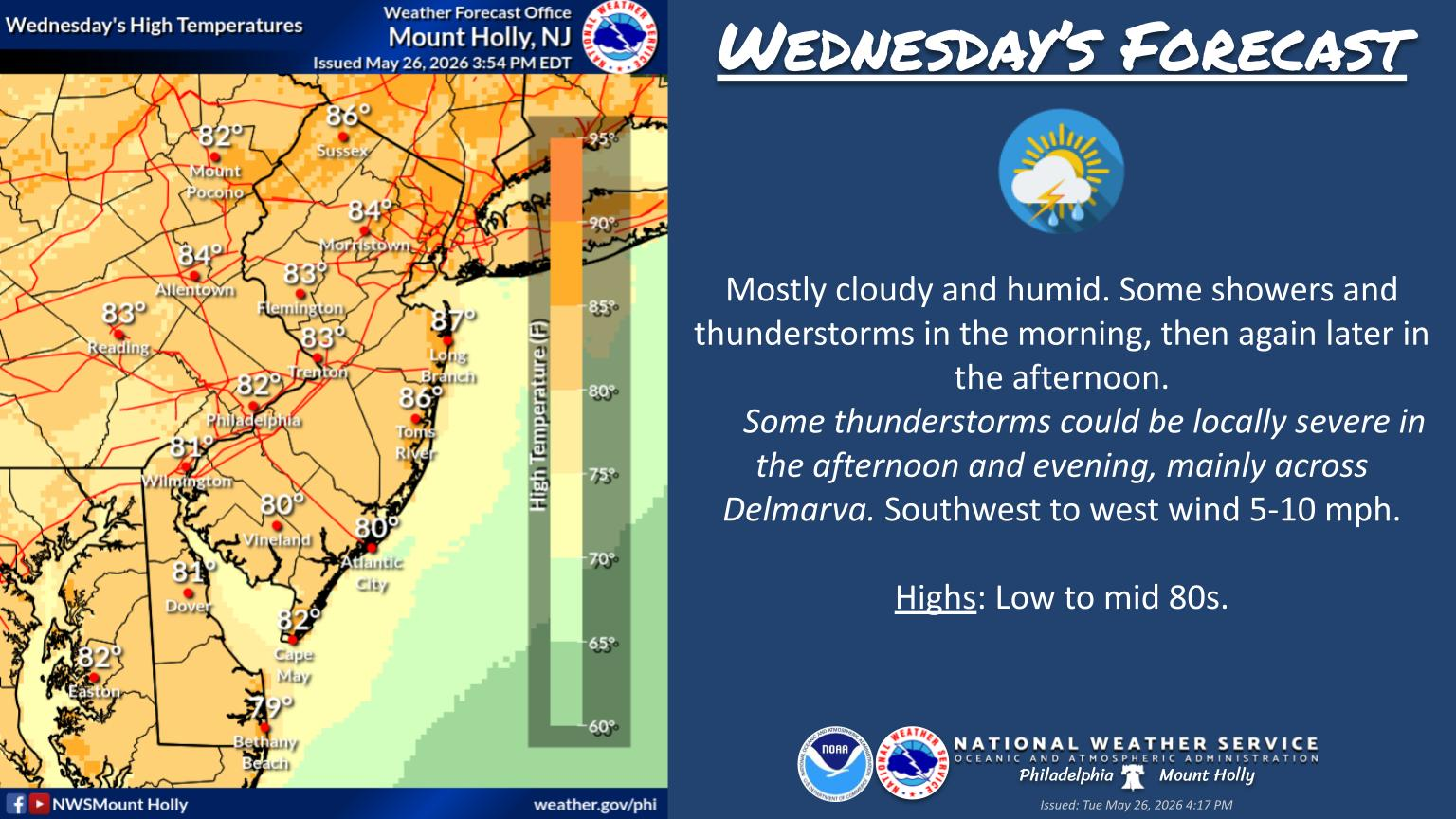
Today's Highs:
TEB: 85
PHL: 85
EWR: 84
New Brnswck: 84
LGA: 83
TTN: 83
ACY: 82
NYC: 81
BLM: 79
JFK: 79
ISP: 78 -
-
81 / 48 just a superb out day
-
4
-
-
56 minutes ago, bluewave said:
This will be a rare occasion that a dense smoke plume prevented 100°+ heat and higher departures.
Could be one of only a few where August had more 90 degree days than July and only in 2021 (since 2010) has Jun / Aug had more 90 degree days than July. EWR at 6 currently
Year July 90° Days August 90° Days Difference 2021 10 13 +3 2018 9 14 +5 2015 11 13 +2 Year June July August 2021 13 10 13 -
On 7/14/2026 at 9:42 PM, SACRUS said:


-
Records:
Highs:
EWR: 101 (1980)
NYC: 101 (1980)
LGA: 101 (1991)
JFK: 99 (2019)
Lows:
EWR: 59 (1997)
NYC: 55 (1890)
LGA: 62 (1997)
JFK: 58 (1965)
Historical:1915: A record high temperature of 115 degrees occurred in Yosemite Valley at the National Park Headquarters, California (around 4,000 feet elevation). This reading was the warmest day in a streak of 7 consecutive days of 110 degrees or higher at Yosemite Valley from the 19th through the 25th.
1921: Montana registered its record maximum 24 hour precipitation as 11.50 inches of rain fell at Circle. (Ref. Wilson Wx. History)
1930 - The temperature at Washington D.C. soared to an all-time record of 106 degrees. The next day Millsboro reached 110 degrees to set a record for the state of Delaware. July 1930 was one of the hottest and driest summers in the U.S., particularly in the Missouri Valley where severe drought conditions developed. Toward the end of the month state records were set for Kentucky with 114 degrees, and Mississippi with 115 degrees. (David Ludlum)
1934 - The temperature at Keokuk, IA, soared to 118 degrees to establish a state record. (The Weather Channel)
1946: The temperature at Medford, OR soared to an all-time high of 115° to begin a two week heat wave. During that Oregon heat wave the mercury hit 100° at Sexton Summit for the only time in 40 years of records. (Extreme Weather p. 276, by Christopher C. Burt)
1953 - Twenty-two inches of hail reportedly fell northeast of Dickinson, ND. (The Weather Channel)
1975: Annandale, Fairfax County, VA 16 people were struck and injured while picnicking. (Ref. Lightning - Virginia Weather History)
1977: A flash flood hits Johnstown, Pennsylvania, on this day in 1977, killing 84 people and causing millions of dollars in damages. This flood came 88 years after the infamous Great Flood of 1889 that killed more than 2,000 people in Johnstown.
1986 - The temperature at Charleston, SC, hit 104 degrees for the second day in a row to tie their all-time record high. (The Weather Channel)
1987 - Thunderstorms produced severe weather across Minnesota, Wisconsin and Michigan. Thunderstorms produced wind gusts to 87 mph at Mosinee, WI, and strong thunderstorm winds capsized twenty-six boats on Grand Traverse Bay drowning two women. Thunderstorms produced nine inches of rain at Shakopee, MN, with 7.83 inches reported in six hours at Chaska, MN. Thunderstorms in north central Nebraska produced hail as large as golf balls in southwestern Cherry County, which accumulated to a depth of 12 inches. (The National Weather Summary) (Storm Data)
1988 - The temperature at Redding, CA, soared to an all-time record high of 118 degrees. Showers and thunderstorms produced much needed rains from New England to southern Texas. Salem, IN, was deluged with 7.2 inches of rain resulting in flash flooding. (The National Weather Summary)
1989 - Showers and thunderstorms in the Middle Atlantic Coast Region soaked Wilmington, DE, with 2.28 inches of rain, pushing their total for the period May through July past the previous record of 22.43 inches. Heavy rain over that three month period virtually wiped out a 16.82 inch deficit which had been building since drought conditions began in 1985. Thunderstorms in central Indiana deluged Lebanon with 6.50 inches of rain in twelve hours, and thunderstorms over Florida produced wind gusts to 84 mph at Flagler Beach. (The National Weather Summary) (Storm Data)
1993: Heavy rains caused flash flooding in the Black Hills of South Dakota. 2.5 inches of rain fell within 30 minutes causing flash flooding in the Lead/Deadwood area and the northern Black Hills. The rapid runoff from the rains also caused numerous mudslides. The mudslides were as deep as three feet on area highways and even washed out a few roads. (Ref. Wilson Wx. History)
1993: Seattle, WA recorded their record maximum temperature of 100 °F which was also recorded on June 9, 1955. (Extreme Weather p. 278, by Christopher C. Burt)
1994: Several separate lightning bolts struck Camp Pickett, VA injuring seven officers. Two suffered serious injuries and had to be resuscitated several times. Most of the men were injured while inside tents with metal poles. (Ref. Lightning - Virginia Weather History)
1997: 32.54 inches of rain fell at Dauphin Island Sea Lab during the slow passage of Hurricane Danny. This set Alabama’s record 24-hour maximum precipitation record. In total 36.74 inches of rain was dumped by Danny here, 26 inches of which fell in just 7 hours the previous day. (Ref. Wilson Wx. History)
2003: A hailstorm (had ping-pong to baseball size) damaged most houses and vehicles on the east side of North Platte Nebraska; $7 million damage. A woman was struck on her head by a large hailstone in the Wal-Mart parking lot. She had to be taken to the hospital for stitches.
(Weather Guide Calendar with Phenomenal Weather Events 2007 Accord Publishing, USA)2005: Hurricane Emily made landfall in northern Mexico. When the central pressure fell to 29.43 inches of mercury, and its sustained winds reached 160 mph on the 16th, Emily became the strongest hurricane ever to form before August, breaking a record set by Hurricane Dennis just six days before. It was also the earliest Category 5 hurricane ever recorded in the Atlantic basin, beating Hurricane Allen's old record by nearly three weeks.
-
74 / 54 gorgeous day today, low to mid 80s. Front boundary pushes north tomorrow with southerly flow , humid , storms and chance for the next >1 inche of rain. Im less enthused that we clear our or have such a nice Wednesday, i think the boundary / clouds / showers linger into Wed. The period Thursday through the coming weekend looks great - but still throw caution with the trough in place that systems and rain could materialize, but overall looking below normal through the 27th. Beyond there moderation warmer and hot close and overall warmer - hot as western heat comes east. -
Today's Highs: rain doing its part to keep the park overgrowth and cooler
ACY: 84
PHL: 84
New Brnswck: 83
LGA: 83
EWR: 82
BLM: 82
JFK: 82
TEB: 81
TTN: 80
ISP: 80
NYC: 79-
1
-
-
Bertha soon to be
-
80 / 69 as drier air filters in with some cumulus , can also see stubborn lingering smoke clear out from earlier
-
2
-
-
Hope this forecast verifies for northern Minnesota and Canada with 0.5 - more inches of rain on the wild fires. Back south Bertha to keep southeast / ec wet , also notice the southwest monsoon moisture kinking into gear.
-
2
-
-
80% Bertha forms in the next day or two
-
7/18 rainfall
EWR: 2.37
JFK: 1.63
LGA: 1.57
NYC: 1.52-
1
-
-
Records:
Highs:
EWR: 100 (2013)
NYC: 102 (1977)
LGA: 100 (2013)
JFK: 97 (1963)
Lows:
EWR: 60 (1962)
NYC: 57 (1924)
LGA: 62 (2000)
JFK: 61 (1962)
Historical:1850: Tropical storm to the east of DC caused trees and signs to be blown down and some buildings were damaged. (Ref. WxDoctor)
1886 - A hurricane from the Gulf of Mexico crossed Florida causing great damage from Cedar Keys to Jacksonville. (David Ludlum)
1886: The 1886 Atlanta Hurricane season was a very active year with ten hurricanes, seven of which struck the United States. During the evening hours of July 18th, a category 1 storm made landfall near Homosassa Springs, Florida. Damage was slight as the area was thinly inhabited. The hurricane weakened to tropical storm status south of Gainsville and emerged on the eastern side of Florida, south of Jacksonville during the morning hours of the 19th. This was the fourth hurricane to make landfall in the United States.1935: Boston, Massachusetts recorded the highest average one minute wind velocity from the northwest at 52 mph. (Ref. NOAA Boston Weather Events)
1960 - Cow Creek and Greenland Ranch in Death Valley, CA, reported morning lows of 102 degrees. The afternoon high at Greenland Ranch was 124 degrees, and the high at Cow Creek that afternoon was 126 degrees. The coolest low for the entire month for both locations was 82 degrees. (The Weather Channel)
1972: The record coldest July temperature was tied at Billings, MT at 41° (also occurred 7/4/1972). The high for the day was a chilly 47°, the only occurrence of a July high temperature less than 50°. (Ref. Wilson Wx. History)
1974 - A severe thunderstorm with winds to 80 mph and up to two inches of rain washed out four to five foot deep sections of roadway in Lake Havasu City, AZ. Three persons in a station wagon died as it was carried 3000 feet down a wash by a ten foot wall of water. (The Weather Channel)
1977 - Thunderstorms produced torrential rains over parts of southwestern Pennsylvania. Some places receive more than twelve inches in a seven hour period. The heavy rains cause flash flooding along streams resulting in widespread severe damage. The cloudburst floods Johnstown with up to ten feet of water resulting in 76 deaths, countless injuries, and 424 million dollars damage. (David Ludlum) (The Weather Channel)
1983: July 19, ........"The I-94 Derecho"....ND, MN, IA, WI, MI, IL, IN1987 - Fifteen cities in the western and the southeastern U.S. reported record low temperatures for the date, including Winnemucca, NV, with a reading of 33 degrees. Flagstaff AZ reported a record low of 34 degrees. Afternoon and evening thunderstorms produced severe weather in New York State and New Jersey. High winds and hail two inches in diameter injured two persons and caused considerable damage to crops in the Pine Island area of central New York State. (The National Weather Summary) (Storm Data)
1988 - Thunderstorms in Nebraska produced more than five inches of rain at Red Cloud, including two inches in fifteen minutes. Torrid temperatures continued over California, with record highs of 115 degrees at Red Bluff and 116 degrees at Redding. (The National Weather Summary) (Storm Data)
1989 - Early morning thunderstorms in the Lower Mississippi Valley produced 5.50 inches of rain south of Alexander, AR, in just ninety minutes, and flash flooding which resulted claimed the life of one woman. Thunderstorms in Indiana produced 4.95 inches of rain in twelve hours east of Muncie. Eight cities in the southwestern U.S. reported record high temperatures for the date, including Las Vegas, NV, with a reading of 115 degrees, and Phoenix, AZ, with a high of 116 degrees. The low that night at Phoenix of 93 degrees was the warmest of record for that location. (The National Weather Summary) (Storm Data)
1993: In Winnsboro, SC, lightning hit a nearby tree and resulting debris fell on a car. The driver left the car to sweep debris away, saying “lightning never strikes twice in the same spot.” He was wrong. CPR saved him. The soles of his wife's shoes were also blown off. (Weather Guide Calendar with Phenomenal Weather Events 2011 Accord Pub. 2010, USA)2005 - Severe heat gripped the region during early to mid-July. Las Vegas, NV tied their all-time record high temperature of 117 degrees, equalling the old record set on July 24, 1942.
2006 - The first of two severe thunderstorms hits the St. Louis area, causing the largest power outage in the city's history with over 570,000 people losing electricity.
2006: A derecho impacted a sellout crowd of almost 44,000 St. Louis Cardinals fans, packed into the new Busch Stadium. Winds of about 80 mph whirled around the St. Louis area, sending the fans running for shelter. The winds knocked out power and broke windows out of the press box. Nearly two minutes after the winds began at 100 mph, they stopped, and it started to rain. In all, about 30 people were injured at the stadium -
76 / 65 sunny. Nice day on tap today / Monday dry low - mid 80s. Tue / Wed next shot at greater than an inch of rain widespread with trough into the east and tropical flow below and boundary nearby. We'll see if the heavier rains stay south into the VA area. Beyond there Thu - the coming weekend look overall near - below normal - likely capped in the 80s (no 90s in the perud). Trough lingers into the east and should include unforeseen rain chances in that period. Western ridge and heat builds from the TX area into the plain and comes east 7/27 and beyond , could see a heat back to close the month / start August, but brunt of the strongest heat to the south and west till then.
-
3
-
-
Dewpoint temps up to low mid 70s = 74 here CNJ -
2.25 inches of rain most of which fell between 1:30 and 2:45
-
1
-
-
We'll see if the break and clearing around 3 pm is enough to heat up the atmosphere for a more widespread 6pm round2-
1
-
-
1 minute ago, NEG NAO said:
some clearing to the south - maybe depends on the smoke

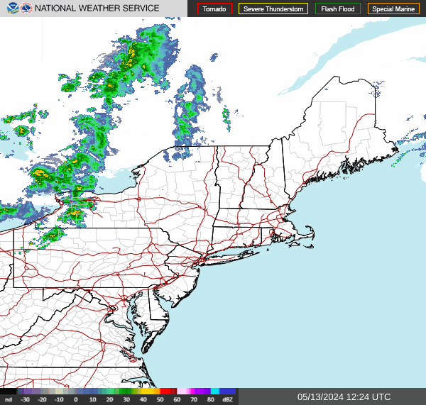
Short lives as the batch of showers/rain in CPA coming in the next hour or two
-
1
-
-
-
-
Records:
Highs:
EWR: 104 (2012)
NYC: 101 (1953)
LGA: 101 (2012)
JFK: 100 (2013)
Lows:
EWR: 58 (1946)
NYC: 57 (1925)
LGA: 62 (1962)
JFK: 58 (1962)
Historical:1889 - A cloudburst in West Virginia along the small creeks in Wirt County, Jackson County and Wood County claimed twenty lives. Rockport, WV, reported nineteen inches of rain in two hours and ten minutes that Thursday evening. Tygart Creek rose 22 feet in one hour, and villages were swept away on Tygart, Slate, Tucker, and Sandy Creeks. (The Weather Channel)
1936 - The all time record high temperature for the state of Kansas was set when a 121-degree high temperature fried Fredonia. (US National Weather Service Wichita)
1936: This day marked the end of the hottest period on record for La Crosse, WI. From the 5th through the 18th, temperatures climbed to 90° or better everyday, and at or above 100° eight times. During this time six record temperatures were set and the average high temperatures for the period was 101.0°.
(Ref. Wilson Wx. History)
1942: A record deluge occurred at Smethport in northern Pennsylvania, with 30.7 inches in just six hours. The downpours and resultant flooding in Pennsylvania were devastating. The following U.S. records were set at Smethport, PA: rainfall in three hours: 28.50 inches, rainfall in 4 hours and 30 minutes: 30.70 inches and 12-hour rainfall: 34.30 inches.(Ref. Wilson Wx. History)1942 - A record deluge occurred at Smethport in northern Pennsylvania, with 30.7 inches in just six hours. The downpours and resultant flooding in Pennsylvania were devastating. (David Ludlum)
1970: A tropical depression formed east of the Yucatan Peninsula. As the system developed into Tropical Storm Becky, it provided National Hurricane Center forecasters their first opportunity to study the evolution of a tropical cyclone with the aid of time-lapse movies of ATS (Applications Technology Satellite) photographs in real time, or, The Movie Loop. Becky moved into the Florida panhandle as a tropical storm. (Ref. Wilson Wx. History)
1972: Heavy rain, unofficially measured at 10 to 11 inches, fell in the Mooreland and Mutual areas of Woodward County Oklahoma. The heavy rain caused severe soil erosion, but crop damage was minimal, as wheat already had been harvested. (Ref. Wilson Wx. History)1986 - One of the most photo-genic tornadoes touched down in the northern suburbs of Minneapolis, MN, during the late afternoon. The very slow moving tornado actually appeared live on the evening news by way of an aerial video taken by the KARE-TV helicopter crew. The tornado, unlike most, was quite the prima donna, staying visible to tens of thousands of persons for thirty minutes. It was moderate in intensity, with winds of 113-157 mph, and caused 650 thousand dollars damage. (Storm Data)
1987 - Cool weather prevailed in the western U.S. Seven cities reported record low temperatures for the date, including Alamosa, CO, with a reading of 38 degrees. The low of 52 degrees at Bakersfield, CA, was a record for July. Up to eight inches of snow covered the Northern Sierra Nevada Range of California from a storm the previous day. During that storm, winds gusting to 52 mph at Slide Mountain, NV, produced a wind chill reading of 20 degrees below zero. Susanville, CA, reached 17 degrees that previous day, Blue Canyon, CA, dipped to a July record of 36 degrees, and the high of 44 degrees at Klamath Falls, OR, smashed their previous record for July by ten degrees. (The National Weather Summary)
1988 - Sweltering heat continued in California, with record highs of 111 degrees at Redding and 112 degrees at Sacramento. Death Valley, CA, hit 127 degrees. Late afternoon and evening thunderstorms in the Central Plains Region produced baseball size hail at Kimball, NE, wind gusts to 79 mph at Colby, KS, and six inches of rain near Lexington, NE. (The National Weather Summary) (Storm Data)
1989 - Thunderstorms produced severe weather in Oklahoma, northern Texas and Arkansas during the afternoon, and into the night. Thunderstorms produced baseball size hail at Stamford, TX, and wind gusts to 92 mph near Throckmorton, TX. Record heat continued in the southwestern U.S. Phoenix AZ reported a record high of 115 degrees, and a 111 degree reading at Midland, TX, was second only to their all-time record high of 112 degrees established sixteen days earlier. (The National Weather Summary)
1992: On this date through the 18th, Thunderstorms crossed Wayne County in western New York State dumping heavy rains over already saturated grounds and swollen streams. Rainfall amounts exceeded six inches in two hours on the 17th. (Ref. Wilson Wx. History)
1993: In south central Kansas, heavy rains in and around Stafford County caused flooding of the normally dry Antelope Creek. Flooding of roads and streets began in Radium during the morning hours. The flooding continued until the morning hours on the 19th. This was the worst flooding in Radium since the spring of 1973. Flooding continued until about 9 am on the 19th. (Ref. Wilson Wx. History)
1996: An F5 tornado struck Oakfield, WI during the evening, injuring 17 people and destroying 47 of the 320 homes in the town. Damage estimates totaled over $40 million dollars. In addition, 56 homes as well as numerous businesses and churches sustained heavy damage. A massive rainstorm in north central and northeast Illinois led to widespread flooding. Aurora reported 16.91 inches of rain, establishing a state record for the most rain in a single day. Other heavy totals included 13.60 inches at Joliet, 9.24 inches in Wheaton, 8.09 inches in DeKalb, and 7.82 inches at Elgin.
(Ref. Wilson Wx. History)
1997: Hurricane warnings were posted along the Gulf Coast from Louisiana to Alabama as Hurricane Danny headed toward shore, first brushing southeastern Louisiana where tropical storm force winds and high tides caused severe erosion. Grand Isle, LA recorded a wind gust to 95 mph shortly before midnight. 100 mph winds and torrential rains, downed power lines, damaged or sunk boats and left flooding in its wake.
Thunderstorms developed ahead of a strong cold front and brought high winds and large hail to the western southern tier, Niagara frontier and Genesee Valley in western New York State. A 74 mph gust was recorded in Orchard Park. Hail, as large as golf balls, damaged crops in Niagara and Orleans counties. Several fires were reported as a result of lightning strikes. (Ref. Wilson Wx. History)
2003: Miles City, MT set their all-time high temperature record with 113°. Highs of 100° or higher occurred 6 times between the 12th through the 19th. (Ref. Wilson Wx. History) .
2008: A man and a woman went outside a home in Standish, ME to get a pair of sunglasses the family dog had taken from 1 of the 3 young children inside. Unfortunately, lightning hit a nearby tree, then traveled through the ground, killing both people. (Weather Guide Calendar with Phenomenal Weather Events 2011 Accord Pub. 2010, USA)
2010: Thunderstorm winds gusted to 72 mph at BWI late evening on 18th. Ref. July PRESTO Page 1

July 2026
in New York City Metro
Posted
The next batch / round into PA
