

SACRUS
-
Posts
13,169 -
Joined
-
Last visited
Content Type
Profiles
Blogs
Forums
American Weather
Media Demo
Store
Gallery
Posts posted by SACRUS
-
-
30 minutes ago, LibertyBell said:
after mid July it's fair game because we'll have enough time to reload-- see the summers of 1953, 1966 and 1983 as prime examples of summers with multiple 100+ degree heatwaves.
'66 was a mid Jun - mid July focused heat summer,
1983 was hot throughout Jun-Jul-Aug / early Sep,1
953 was similar but had share of cooldowns culminating in the record torch late Aug-early September heat.-
 1
1
-
-
Just now, bluewave said:
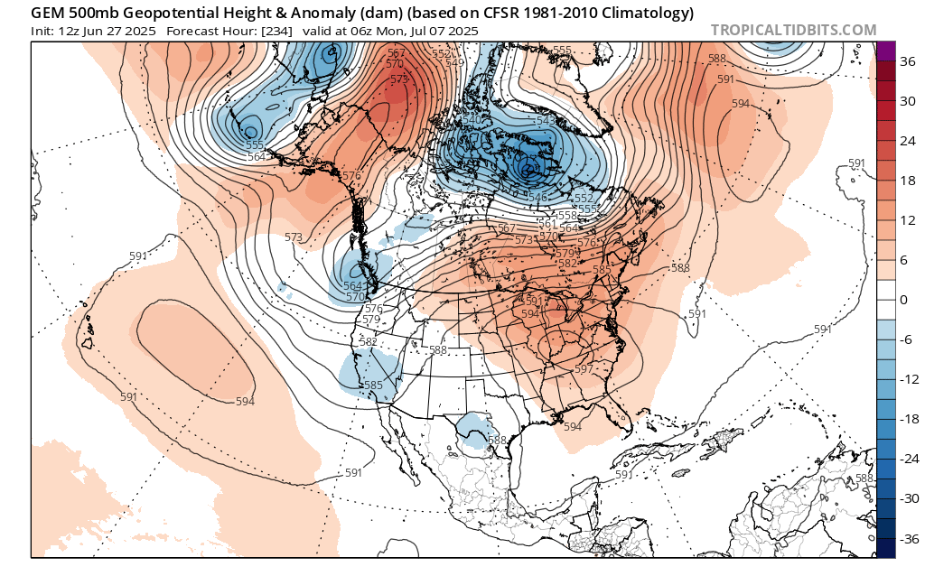
Unfortunately, the 12z guidance wants to reload another 594+ ridge in about 10 days. I was hoping we could get a break from the 100° heat. But it looks like the pattern may have other ideas. Past instances of 103° to 105° heat didn’t usually have such a quick follow up of the ridge rebuilding. So maybe we can keep it more in the 95° to 100° range in early July rather than pushing 105° again. But who knows for sure with this climate.

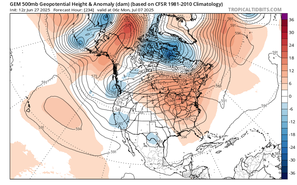
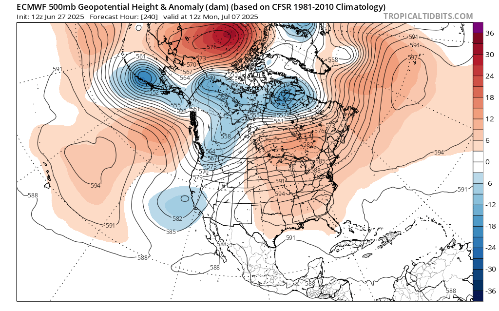
The Euro op has 600 DM ridge center in MO/KS at H 288
-
1
-
 1
1
-
-
High so far here is 69
-
3 minutes ago, forkyfork said:
i grew up in bayonne and a huge storm in the early/mid 90s is what got me into wx. it might be this one
2.05 inches of rain between the 29- 30 , 1994 at EWR
-
1
-
-
-
-
25 minutes ago, Sundog said:
Are almost all of these fake midnight highs?
Most in the area north of PHL had overnight Wed - Thu or were mtached in the pm.
-
1
-
-
Again, not ideal when convective in nature focus this evening/ overnight, Sat evening, Mon PM / Tuesday. Looks drier Wed - Fr (4th)
-
On 4/26/2011 at 9:17 AM, SACRUS said:
2025:PHL: 7 (Apr: ; May: ; Jun: 7 ; Jul: ; Aug: ; Sep: )
EWR: 8 (Apr: ; May: ; Jun: 8 ; Jul: ; Aug: ; Sep: )
TTN: 4 (Apr: ; May: ; Jun: 4 ; Jul: ; Aug: ; Sep: )
LGA: 6 (Apr: ; May: ; Jun: 6; Jul : ; Aug: ; Sep: )
ACY: 8 (Apr: ; May: ; Jun: 8 ; Jul: ; Aug: ; Sep: )
TEB: 8 (Apr: ; May: ; Jun : 8 ; Jul: ; Aug: ; Sep: )
NYC: 3 (Apr: ; May: ; Jun: 3; Jul: ; Aug: ; Sep: )
JFK: 5 (Apr: ; May: ; Jun: 5; Jul: ; Aug: ; Sep: )
ISP: 4 (Apr: ; May: ; Jun: 4 ; Jul: ; Aug: ; Sep: )New Brunswick: 5 (Apr: ; May: ; Jun: 5 ; Jul: ; Aug: ; Sep: )
BLM: 5 (Apr: ; May: ; Jun: 5 ; Jul: ; Aug: ; Sep: )89 Degree Days:
New Brnswck: 2
TTN: 1
TEB: 1
BLM: 1
------------------------------------------------------------------------------------------------------------------------------------------------------------------------------------------
6/26 Highs
PHL: 92
ACY: 90
EWR: 86
NYC: 85
JFK: 85
ISP: 84
TEB: 84
New Brnswck: 84
LGA: 83
TTN: 83
BLM: 79-
1
-
-
6/26 Highs
PHL: 92
ACY: 90
EWR: 86
NYC: 85
JFK: 85
ISP: 84
TEB: 84
New Brnswck: 84
LGA: 83
TTN: 83
BLM: 79-
1
-
-
8 hours ago, Wxoutlooksblog said:
My 5th floor apartment in Douglaston facing west with open sky got so hot with the westward facing wall of the building and now an easterly wind I am running my a/c full blast to try to fully get the heat out. I ran it all night last night and probably will need to run it over night another night to finally get it comfortably cool. Then it warms up with plenty of humidity on Saturday. Unless we sneak a 90 in on Saturday, Sunday, Monday or Tuesday (and it's unlikely since winds will be out of the s-sw) I do not think we see another 90+ day in NYC until the second or more likely the third week of July.
WX/PT
Even central park on Monday may make a run at 90, 850 MB temps spiking to >18c , looks p cloudy.
-
1
-
-
Records:
Highs:
EWR: 101 (1966)
NYC: 101 (1966)
LGA: 97 (2003)
JFK: 98 (1963)
Lows:
EWR: 52 (1940)
NYC: 55 (1940)
LGA: 56 (1972)
JFK: 54 (1965)
HIstorical:1881: Intense downpour of 2.34 inches in Washington, DC. was recorded in 37 minutes.
1901 - There was a rain of fish from the sky at Tiller's Ferry. Hundreds of fish were swimming between cotton rows after a heavy shower. (David Ludlum)
1915 - The temperature at Fort Yukon AK soared to 100 degrees to establish a state record. (The Weather Channel)
1923" Boston, Massachusetts recorded its lowest pressure 29.26 inches of mercury for the month of June. (Ref. NOAA Boston Weather Events)
1957 - Hurricane Audrey smashed ashore at Cameron, LA, drowning 390 persons in the storm tide, and causing 150 million dollars damage in Texas, Louisiana and Mississippi. Audrey left only a brick courthouse and a cement-block icehouse standing at Cameron, and when the waters settled in the town of Crede, only four buildings remained. The powerful winds of Audrey tossed a fishing boat weighing 78 tons onto an off-shore drilling platform. Winds along the coast gusted to 105 mph, and oil rigs off the Louisiana coast reported wind gusts to 180 mph. A storm surge greater than twelve feet inundated the Louisiana coast as much as 25 miles inland. It was the deadliest June hurricane of record for the U.S. (David Ludlum) (The Weather Channel)
1978: Worst thunderstorm in 20 years wind gust greater than 70 mph in the Washington, DC. with over 1000 trees down in DC. and 100,000 homes with no power. (The Washington Post)1987 - Thunderstorms moving out of Nebraska produced severe weather in north central Kansas after midnight. Thunderstorm winds gusting to 100 mph damaged more than fifty camping trailers at the state park campground at Lake Waconda injuring sixteen persons. Thunderstorm winds gusted to 80 mph at Beloit and Sylvan Grove. (The National Weather Summary) (Storm Data)
1988 - The afternoon high of 107 degrees at Bismarck, ND, was a record for the month of June, and Pensacola, FL, equalled their June record with a reading of 101 degrees. Temperatures in the Great Lakes Region and the Ohio Valley dipped into the 40s. (The National Weather Summary)
1989 - Thunderstorms produced severe weather from the Ohio Valley to western New England. Thunderstorm spawned six tornadoes, and there were 98 reports of large hail and damaging winds. Tropical Storm Allison spawned six tornadoes in Louisiana, injuring two persons at Hackberry. Fort Polk LA was drenched with 10.09 inches of rain in 36 hours, and 12.87 inches was reported at the Gorum Fire Tower in northern Louisiana. (The National Weather Summary) (Storm Data)
1992: A severe thunderstorm dropped hail to golf ball size near the top of WA’s Sherman Pass; accumulations to 8 inches. 2 motorcyclists were injured in separate accidents due to the hail-clogged highway. Several cars slid into ditches. (Ref. Weather Guide Calendar with Phenomenal Weather Events 2011 Accord Pub. 2010, USA)
1994: Waste Isolation. Pilot Plant, New Mexico: High temperatures in the Southwest as New Mexico sets its hottest temperature ever: 122°F the state record.All-time record temperatures for the state tied at Tipton, Oklahoma: 120°F.
1995: The Madison County Flood on June 27, 1995, was the worst flash floods Virginia had seen since the remnants of Camille dropped up to 30 inches of rain one night in Nelson County in August 1969. The Nelson County flood ranked as one of the nation's worst flash floods of this century and resulted in the deaths of 117 people. The Madison County flood killed one person.
-
67 / 58 clouds . 24 hours remaining in the June gloom / onshore flow. Flow comes around Sw - tomorrow. Much warmer. Sat - Mon and with enough sun the hotter spots get to 90 or above, especially Monday with another area of 850 MB temps >18c crossing through. Storms bring locally > 1 inch and perhaps up to 2 inches focus later tonight, Sunday night and Tuesday afternoon. Beyond there the drier / warm 3rd and 4th. The 5/6 weekend is a mix pending. Beyond there into the week of the 8th hotter.
6/27 : Cool / onshore showers
6/28 - 7/2 : Warm - hot / humid, storms (focus Fri PM, Sun PM, Tue PM) 1-2 inches locally
7/3 - 7/4 : Warm / Dry fourth
7/5 - 7/7 : could be wetter / humid
7/8 - beyond : turning hotter
-
1
-
-
67 / 58 clouds . 24 hours remaining in the June gloom / onshore flow. Flow comes around Sw - tomorrow. Much warmer. Sat - Mon and with enough sun the hotter spots get to 90 or above, especially Monday with another area of 850 MB temps >18c crossing through. Storms bring locally > 1 inch and perhaps up to 2 inches focus later tonight, Sunday night and Tuesday afternoon. Beyond there the drier / warm 3rd and 4th. The 5/6 weekend is a mix pending. Beyond there into the week of the 8th hotter.
7/3 - 7/4 : Warm / Dry fourth
7/5 - 7/7 : could be wetter / humid
7/8 - beyond : turning hotter-
1
-
-
12z was similar - GFS/Euro a bit cooler the 5th-6th
-
-
19 minutes ago, FPizz said:
80 again! Sun trying to pop out
breaking out into some sun here in CNJ as well

-
1
-
-
3 hours ago, forkyfork said:
sat-mon looks like our next potential heat wave
Sun contingent Even Tue (7/1) /Wed (7/2) pending on clouds/rain could push 90 in the hot/sunnier spots. Thu/ th fourth look warm as well.
-
3 hours ago, forkyfork said:
we all had midnight highs in the 80s so this little cool blip will only show up as one day in the records
42 hour cool down.
-
76 / 65 / 84 was the high before the cloud deck came n.
-
79 / 70 as we goto a So-Cal marine layer the next 42 hours.
-
June gloom rolling NE - SW
-
24 minutes ago, winterwarlock said:
So once again another weekend with rain chances..only 1 true beach day so far on the weekend yet
GFS went drier for next wekeend, while the ecm is still stormy/wet 7/5 - 7/6, this weekend looks like storms focus Sat pm/evening, less so on Sunday.
-
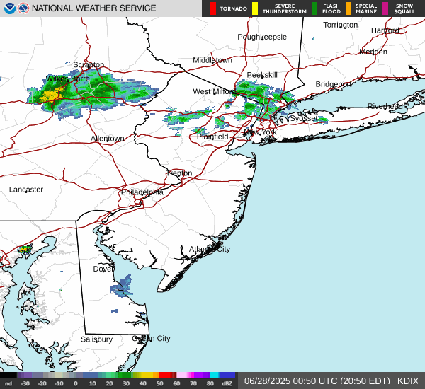
Rain focused north today and east
June 2025 discussion-obs: Summerlike
in New York City Metro
Posted
I attached the readings in the post above as a pdf for EWR. Similar coold downs for sure and lower minimums in 1953