

SACRUS
-
Posts
13,162 -
Joined
-
Last visited
Content Type
Profiles
Blogs
Forums
American Weather
Media Demo
Store
Gallery
Posts posted by SACRUS
-
-
1 hour ago, LibertyBell said:
that 0.22 in August was mostly on the 31st I think. I thought we'd make it through the entire month and just before midnight as the last day of the month was about to end this really weird front came down from the north and deposited that small amount of rain just before midnight :-(
JFK 5th, 6th and 12th had light rainfall in Aug 1995
-
 1
1
-
-
-
-
Kick in the gut MCS about through raining into NJ - clearing continues to build from the NE. We have 3.5 hours to heat up
83/ 70 here
-
1 minute ago, LibertyBell said:
This might have been our final rain for the summer, I remember there was zero rain in August that year and all those wildfires.
JFK
1995Rainfall totals
May: 3.44
June: 2.73
Jul: 3.37
Aug: 0.22
Sep: 3.41
-
1
-
-
Up to 83 with the slowly visible sun

-
16 minutes ago, Sundog said:
Never thought I'd be sitting at 75 degrees at noon today, but here we are.
Kind of the worst timing and track to spoil part of the day - second half of the day looking more salvageable
-
77 / 72 here skie s brightening
-
Uniquely odd clearing building down NE-SW (ish)
-
3
-
-
76 . 70 steam bath ensuing once we clear out
-
Rain slowing down about 0.10
-
6 minutes ago, Sundog said:
Does this have any implications for tomorrow's wind direction?
Good question this further sw track argued the ridge is building in a bit later so would go with more onshore component eastern sections.
-
1
-
-
15 minutes ago, LibertyBell said:
the only place that will hit 90 today will be Newark and even they will be close.
Once the sun comes out (we'll see when) maybe 1/2 itll be off to the races and we'll see if we hve some kate 4/5PM highs.
Cloud magnet strikes again
-
1
-
-
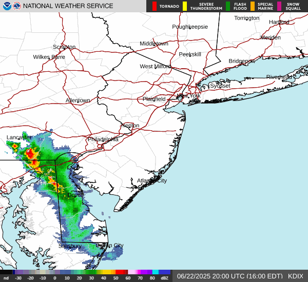
at this trajectory SSE of the mcs lp around the building ridge even Balt may get in the rain/clouds, looks like the low is about to cut south west of NJ
-
4
-
-
-
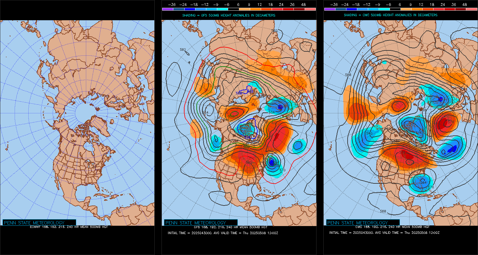
Ridge into the east to open JUl
-
About 300 hours away. Both the GFS and EURO in relatively tight agreement. Highs mid / upper 80s - and dry. Leading in its humid/warm with storms 2-3 , beyond 5-6 GFS maintaines warm/humis storm potential and euro builds in next wave of heat.
-
1
-
-
Cloud magnet back and winning out for the next 3-4 hours
-
3-4 hours and this mess should pass but it adds , for some, to the streak of wet weekend days
-
1
-
-
6 minutes ago, Sundog said:
Tuesday there's a very good chance
Tue - Wed (NJ locations)
-
Records:
Highs:
EWR: 101 (1988)
NYC: 98 (1988)
LGA: 99 (1988)
JFK: 94 (2012)
Lows:
EWR: 48 (1940)
NYC: 52 (1940)
LGA: 52 (1992)
JFK: 55 (1992)
Historical:1886: At Lynchburg, a "terrific rain" led to street flooding, setting a new record for the wettest June at the site (5.44 inches Record at this time). In Washington, DC, (4.16 inches Record at this time) of rain fell on the 22nd alone, setting a 24-hour rainfall record for June. (Ref. for Heavy Rainfall)
1906: A destructive hailstorm struck the town of Chelsea, VT, covering an area 1 by 10 miles. There were drifts up to two feet deep, and most crops were destroyed. (Ref. Wilson Wx. History)
1919: 59 people were killed as an F5 tornado ripped through the town of Fergus Falls, MN. 400 buildings were destroyed. A blank check was found over 60 miles away and lumber was carried 10 miles. (Ref. Wilson Wx. History)1928: A farmer near Greensburg, KS looked up into the heart of a tornado. He described its walls as "rotating clouds lit with constant flashes of lightning and a strong gassy odor with a screaming, hissing sound."
1944: A violent tornado, which touched down in southwest Wisconsin, crossed the border into Illinois, northeast of Freeport. Both states had at least $1 million damage each. In Illinois, 66 farms lost barns, and 21 homes were destroyed. Two people were killed in Illinois, with seven more in Wisconsin. (Ref. Wilson Wx. History)
1947 - Twelve inches of rain fell in forty-two minutes at Holt, MO, establishing a world rainfall record. That record was tied on January 24-25, 1956, at the Kilauea Sugar Plantation in Hawaii, as their state record was established with 38 inches of rain in 24 hours. (The Weather Channel)
1972 - Hurricane Agnes deluged Pennsylvania and New York State with torrential rains resulting in the most costly flood in U.S. history. In the Middle Susquehanna Valley of Pennsylvania, 24 hour rainfall amounts were generally 8 to 12 inches, with up to 19 inches in extreme southwestern Schuylkill County. At Wilkes-Barre, PA, the dike was breached destroying much of the town. Flooding resulted in 117 deaths and 3.1 billion dollars damage. (David Ludlum)
1981 - A young woman from Lubbock, TX, was struck by lightning. The bolt of lightning struck just above her right shoulder near her neck, and passed right to left through her body, tearing her warm-ups, causing her tennis shoes to explode, and lifting her two feet into the air. (The Weather Channel)
1987 - Thunderstorms in southern Texas produced wind gusts to 116 mph near Quemado. Thunderstorms in New York State produced 5.01 inches of rain in 24 hours at Buffalo, an all-time record for that location, and produced an inch of rain at Bath, PA. The temperature at Fairbanks AK soared to 92 degrees, establishing a record for the date. (The National Weather Summary) (Storm Data)
1988 - Sixty-five cities in twenty-four states reported record high temperatures for the date. Tucson AZ reported an all-time record high of 114 degrees, surpassing the previous record of 112 degrees established a day earlier. Highs of 98 degrees at Pittsburgh, PA, and 100 degrees at Baltimore, MD, tied records for the month of June. (The National Weather Summary)
1989 - Record cold temperatures were reported in the High Plains Region. Rapid City, SD, reported a record low of 39 degrees, in sharp contrast to their record high of 102 degrees two days earlier, on the 20th. (The National Weather Summary)
2003: A hailstone measuring 7.0 inches in diameter with a circumference of 18.75 inches and weighing 1.33 pounds falls in Aurora, Nebraska. The National Weather Service reports this is the second largest hailstone ever documented in the U.S. by weight, and the largest by size at that time. The world's largest hailstone NOW was produced from storms in South Dakota; 8" in diameter and 1.9375 lbs. on July 23, 2010.
2009: Florida: Temperature records tumble with Vero Beach leading the record heat parade with a record high of 102°F and a heat index of 111°F. Elsewhere in the state, Tallahassee hits 103°F; Daytona and West Palm Beach, 96°F and Miami 98.°F.
(Ref. WxDoctor)
2016: June 22-24. Part of a severe weather outbreak that produced over two dozen tornadoes from Illinois to West Virginia, up to 10 inches of rain fell in just 12-24 hours on June 23, setting off West Virginia's third deadliest flood. Twenty-three people lost their lives.-
1
-
-
75 / 67 here clouds early from the MCS that was a bit more widespread and too a more SSE track than some modeled. Clouds this morning , rain in northern areas from storms will limit max heating to low - mid 90s. Areas in CNJ south who avoid rain and clear out sooner may get to the upper 90s. Clearing by noon (3-4 hours. Hot Mon - Wed 85 MB temps >21 c, only wind flow direction and clouds, and maybe park overgrowth will get in the way of the century mark Tue/Wed. Thus may be dealing with lingering debris clouds but there will be a sharp change from upper 90s to low 90s to 80s near the city.
Friday onshore flow and scattered showers. We'll see how much we clear out and if we can get a dry weekend 28-29th.
Beyond there overall warm - hot / humid and wetter to open with ridge and next heat building north and east towards the 3rd.

-
11PM
EWR: 85
LGA: 82 (wenr up a degree from 951)
NYC: 80
New Brnswck: 79
JFK: 78 (up 6) -
Warm night
Still in the 80s

June 2025 discussion-obs: Summerlike
in New York City Metro
Posted
Notice when we have ridges of this magnitude and strong, the heat overperforms - assuming enough clearing and no seabreeze, outside of central park.