
SACRUS
-
Posts
15,692 -
Joined
-
Last visited
Content Type
Profiles
Blogs
Forums
American Weather
Media Demo
Store
Gallery
Posts posted by SACRUS
-
-
Post cards
-
 1
1
-
 1
1
-
 2
2
-
-
-
-
Just now, Prue11 said:
What time is the heaviest snow and winds modeled for LI?
2000 (8pm) - 800 monday-
 1
1
-
-
2/22 18z HRDPS (HRDPS = High-Resolution Deterministic Prediction System)
Convection-allowing (~2.5 km) regional model
Snow

-
3 minutes ago, winterwarlock said:sort of meh wet accumulations in Belle Mead after 2 hours of sticking and 4 hours of total snow
approaching an inch on grass and about half inch on paved where its very wet
31 and havent got into any heavier rates yet
Heavier bands one the way

-
 2
2
-
 1
1
-
-
2/22 21z RRFS (planned to replace nam) 4AM Mondaythrough 100am monday

snow
-
-
Latest 18h HRR through 100AM Monday

Snow

-
 1
1
-
-
-
-
2/22 18z GFS
Snow

-
Just now, MANDA said:
My vote is leave everything in this thread. Easier, IMO.
Agreed - its all related to the storm obs, radar , short term forecasts, etc.
-
 1
1
-
-
-
-
20z hrr through 9:00 AM - a little moremore to go after this


-
-
more important


-
 2
2
-
-
2/22 18z RGEM for trends fwiw
-
Feb 19:
Records:
Highs:
EWR: 69 (2017)
NYC: 66 (1997)
LGA: 66 (2017)
JFK: 68 (2017)
Lows:
EWR: 1 (1936)
NYC: 1 (1936)
LGA: 9 (2015)
JFK: 9 (2015)
Historical:1884 - Severe thunderstorms spawned sixty tornadoes in the southeastern U.S., killing more than 420 persons and causing three million dollars damage. Georgia and the Carolinas hardest were hit in the tornado outbreak. (David Ludlum)
1888 - A tornado struck Mount Vernon IL. The tornado killed sixteen persons along its 62 mile path. (David Ludlum)
1888: Severe thunderstorms over southern Illinois spawned a violent tornado in Jefferson County and devastated the southeast half of Mount Vernon. The tornado killed 24 people, injured 80 others, and destroyed or damaged 300 homes and 50 businesses. In addition, overturned wood stoves ignited many fires in the wreckage. The tornado currently stands as the 9th deadliest Illinois tornado on record and was one of the first disasters to which the American Red Cross responded.
1954 - High winds across the southern half of the Great Plains, gusting to 85 mph, caused the worst duststorms since the 1930s. Graders were needed in places to clear fence high dirt drifts. (The Weather Channel)
1987 - A winter storm over the southern and central Rockies produced 28 inches of snow at Echo Lake CO, and two feet of snow at Gascon NM and Los Alamos NM. Mora County NM was declared a disaster area following the storm. (The National Weather Summary) (Storm Data)
1988 - Showers and thunderstorms in the southeastern U.S. drenched Valdosta GA with more than five inches of rain, and the 24 hour rainfall total of 7.10 inches at Apalachicola FL more than doubled their previous 24 hour record for February. (The National Weather Summary) (Storm Data)
1989 - An upper level weather disturbance brought heavy snow to parts of Nebraska, with six inches reported at Loup City and Surprise. (The National Weather Summary) (Storm Data)
1990 - A moist Pacific storm worked its way into New Mexico and southern Colorado. Up to 36 inches of snow blanketed the Wolf Creek and Red Mountain passes of southwest Colorado, and up to 15 inches of snow was reported around Trinidad. In New Mexico, the eastern slopes of the Sangre de Cristo Mountains were blanketed with 9 to 28 inches of snow, and 50 to 60 mph wind gusts were reported from Taos to Albuquerque. (The National Weather Summary) (Storm Data)
2011 - Strong winds reaching as high as 40 mph with gusts to 53 mph topple the 48 year old National Christmas tree. The 42 foot tall Colorado blue spruce sat just south of the White House on the Ellipse. It was transplanted there from York, Pennsylvania in 1978. The Weather Doctor
---------------------------------------------------------------------------------------------------------------------------------
Feb 20
Records:
Highs:
EWR: 70 (1939)
NYC: 69 (1939)
LGA: 70 (2018)
JFK: 64 (2018)
Lows:
EWR: 1 (2015)
NYC: 2 (2015)
LGA: 3 (2015)
JFK: 3 (2015)
Historical:
1805: The Potomac River was opened after being closed by ice for a period of two months.(Sandra and TI Richard Sanders - 1987) (Bob Ryan’s 2002 Almanac)
1896: The minimum temperature for the date is +8 °F in Washington, DC. (Bob Ryan’s 2002 Almanac)
1898: Eastern Wisconsin experienced a big snowstorm. Racine received 30 inches, and drifts around Milwaukee measured 15 feet high. (Ref. Wilson Wx. History)
1912: An F3 tornado killed 9 people and injured 50 others as it crossed Shreveport, LA. Centenary College was struck, an event that would be repeated in 1940. (Ref. Wilson Wx. History)
1918: 31.93 inches of rain fell in 24 hours at Honomu, HI located on the northeastern part of the Big Island north of Hilo. (Ref. Wilson Wx. History)
1930: The maximum temperature for the date is 76 °F in Washington, DC and at the peak of heat wave a 76° also at WBO. (Bob Ryan’s 2002 Almanac)
1934: A severe blizzard was in its 2nd day across southern New England. The snowfall was one of Connecticut's worst in modern times with 20 inch accumulations, high winds, and temperatures that dropped from near 32° to 5° during the course of the storm (Ref. Wilson Wx. History)
1953: A snowstorm in Nebraska, South Dakota, Iowa and Minnesota produced drifts ten-feet high which derailed trains.(David Ludlum)
1960: Feb. 18-20 A snowstorm dropped up to two feet in the western Virginia mountains.
1971: On the 20th and 22nd a blizzard blanketed TX Panhandle with 6-26 inches (in Follett) snow; drifts to 12 feet deep. Some cattle from wheat pastures strayed 45 miles when electric fences shorted out from snow. 13,000 head of cattle killed, many smothered or trampled when groups bunched up to keep warm. (Ref. Weather Guide Calendar with Phenomenal Weather Events 2011 Accord Pub. 2010, USA)
1980: Mammoth Mountain, CA in the southern Sierra Mountains received 109 inches of snow between the 13th and 20th. (Ref. Wilson Wx. History)
1987: A storm system over Arizona spread heavy snow from the Southern Rockies into the Southern Plains Region. Thunderstorms in central Texas produced golf ball size hail about the same time north central Texas was being blanketed with up to 8 inches of snow, closing many schools. (The National Weather Summary) (Storm Data)
1988: Snow and strong northerly winds ushered arctic air into the Great Lakes Region. The temperature at Sault Ste Marie, MI plunged from 30 degrees at 5 AM to one below zero by 3 PM with a wind chill reading of 40 degrees below zero. Five cities in Florida reported record high temperatures for the date. The afternoon high of 90 degrees at Lakeland was just a degree shy of their February record. (The National Weather Summary)
1989: Thunderstorms developing during the early afternoon produced severe weather from eastern Texas to Alabama and northwest Florida. Thunderstorms spawned a dozen tornadoes during the afternoon and evening. Thunderstorms also produced 90 mph winds around Vicksburg, MS and 100 mph winds around Jackson, MS. (The National Weather Summary) (Storm Data)
1990: Heavy snow spread into southwestern Kansas and the panhandle region of Oklahoma and Texas. Heavier snowfall totals included 12 inches at Boise City OK, 11 inches at Liberal KS, and 10 inches at Spearman TX. Blowing and drifting snow closed roads in the Oklahoma panhandle. (The National Weather Summary) (Storm Data)
1993: Two strong areas of low pressure, one over Colorado and the other off the coast of Washington state, produced high winds, heavy rain, and heavy snow across the western U.S. Winds gusted to 85 mph at Fort Carson, CO and to 96 mph at Rock Springs, WY. Flagstaff, AZ was deluged with 3.93 inches of rain in 24 hours; their greatest 24 hour rainfall on record. Duck Creek, UT was buried under 49 inches of snow in 48 hours and the Sierra Ski Ranch in California recorded 74 inches of snow over a 4-day period to raise its snow cover to 200 inches.
Farther to the east, a strong overrunning pattern developed ahead of the area of low pressure over Colorado. Sioux City, IA was hit with 14 inches of snow in just 6 hours. (Ref. Wilson Wx. History)
1995: The temperature at the Civic Center in Los Angeles, CA soared to 95°; the highest temperature ever recorded at the location during the month of February. (Ref. Wilson Wx. History)
----------------------------------------------------------------------------------------------------------------------------------------
Feb 21Records:
Highs:
EWR: 80 (2018)
NYC: 78 (2018)
LGA: 79 (2018)
JFK: 65 (2018)
Lows:
EWR: 6 (1959)
NYC: 5 (1968)
LGA: 6 (1968)
JFK: 5 (1968)Historical:
1918 - A spectacular chinook wind at Granville, ND, caused the temperature to spurt from a morning low of 33 degrees below zero to an afternoon high of 50 degrees above zero. (David Ludlum)
1935 - Frequent duststorms occurred in eastern Colorado during the month, forcing schools to close and people to stay indoors. A fatality occurred on this date when two section cars collided on the railroad near Arriba CO, due to poor visibility. (The Weather Channel)
1936 - The temperature at Langdon, ND, climbed above zero for the first time in six weeks. Readings never got above freezing during all three winter months. (David Ludlum)
1971 - An outbreak of tornadoes hit northeastern Louisiana and northern and central Mississippi. The tornadoes claimed 121 lives, including 110 in Mississippi. Three tornadoes accounted for 118 of the deaths. There are 1600 persons injured, 900 homes were destroyed or badly damaged, and total damage was 19 million dollars. (David Ludlum)
1971 - Elk City, OK, was buried under 36 inches of snow to establish a 24 hour snowfall record for the state. (David Ludlum)
1971: A tornado outbreak struck portions of the Lower Mississippi River Valley and the Southeastern United States on February 21–22nd. The two-day tornado outbreak produced at least 19 tornadoes, probably several more, primarily brief events in rural areas, and killed 123 people across three states. The tornadoes "virtually leveled" entire communities in the state of Mississippi.
1987 - Low pressure over central California produced gale force winds along the coast, and produced thunderstorms which pelted Stockton, Oakland and San Jose with small hail. (The National Weather Summary) (Storm Data)
1988 - A storm tracking across southern Canada produced high winds in the north central U.S., with gusted to 90 mph reported at Boulder CO. The high winds snapped trees and power lines, and ripped shingles off roofs. The Kentucky Fried Chicken Bucket was blown off their store in Havre MT. An eighteen foot fiberglass bear was blown off its stand along a store front in west Cody WY, and sailed east into downtown Cody before the owners were able to transport their wandering bear back home in a horse trailer. (The National Weather Summary) (Storm Data)
1989 - Thunderstorms developing during the morning hours spread severe weather across Georgia and the Carolinas. Strong thunderstorm winds caused one death and thirteen injuries in North Carolina, and another four injuries in South Carolina. (The National Weather Summary) (Storm Data)
1990 - Overnight thunderstorms produced heavy rain in central Texas. Rainfall totals ranged up to 2.80 inches at Camp Verde, with 2.20 inches reported at Leakey. Thunderstorms early in the day produced high winds in southern Texas, with wind gusts to 60 mph reported at Alice. Daytime thunderstorms in eastern Texas drenched Rosenberg with four inches of rain. (The National Weather Summary) (Storm Data)
2013: An astonishing 515 cm (202.8" or almost 17') level of snow depth was measured at Sukayu Onsen, Aomori on Honshu Island in Japan, on February 21, 2013, the deepest snow measured at an official weather site in Japan records. (Last Updated in 2020).
--------------------------------------------------------------------------------------------------------------------------------------
2/22Records:
Highs:
EWR: 70 (1997)
NYC: 66 (1997)
LGA: 70 (1997)
JFK: 64 (1991)
Lows:
EWR: 8 (1963)
NYC: 8 (1963)
LGA: 9 (1963)
JFK: 9 (1968)
Historical:1773 - The memorable "Cold Sabbath" in New England history. Many persons froze extremities while going to church. (David Ludlum)
1773: According to David Ludlum, "The memorable Cold Sabbath in New England history" took place on February 22, 1773. "Many persons froze extremities while going to church."
1936 - Although heat and dust prevailed in the spring and summer, early 1936 brought record cold to parts of the U.S. Sioux Center IA reported 42 inches of snow on the ground, a state record. (20th-22nd) (The Weather Channel)
1971: One of the worst snowstorms in Oklahoma history dumped up to 3 feet of snow on northwest Oklahoma from February 20nd to February 22. By the time the snow ended on the 22nd, the city of Buffalo had 36 inches of snow on the ground, setting the state record for storm-total snowfall. Winds of 30 to 50 mph caused snowdrifts up to 20 feet high. Follett, Texas, picked up 26 inches while Amarillo recorded 14 inches.
1986 - A twelve siege of heavy rain and snow, which produced widespread flooding and mudslides across northern and central California, finally came to an end. The storm caused more than 400 million dollars property damage. Bucks Lake, located in the Sierra Nevada Range, received 49.6 inches of rain during the twelve day period. (Storm Data)
1987 - A storm moving northeastward out of the Gulf of Mexico began to spread heavy snow across the Middle Atlantic Coast Region. Thunderstorms in northern Florida produced wind gusts to 65 mph in Alachua County. (The National Weather Summary) (Storm Data)
1988 - Dry weather prevailed across the nation, with windy conditions from the Central Rockies to northern New England. Winds gusted to 58 mph at Cleveland OH, and reached 63 mph at Erie PA. Winds in the Central Rockies gusted to 120 mph at Mines Peak CO and Rendezvous Peak WY. (The National Weather Summary) (Storm Data)
1989 - Strong northwesterly winds ushering cold arctic air into the north central U.S. produced snow squalls in the Great Lakes Region, with heavy snow near Lake Michigan. Totals in northwest Indiana ranged up to 24 inches at Gary, and up to 16 inches buried northeastern Illinois. (The National Weather Summary) (Storm Data)
1990 - Thunderstorms developing along and ahead of a cold front produced severe weather from southern Mississippi to North Carolina. One thunderstorm spawned a tornado just prior to dawn which touched down near Opp AL injuring ten persons and causing half a million dollars damage. Thunderstorm winds injured four persons south of Troy AL, and five people at Columbus GA. Thunderstorm winds gusted to 76 mph at Dothan AL. (The National Weather Summary) (Storm Data)
-
33/32 snowing. Week looks to hover near / below normal with more rain/mix or snow towards thu. Wed - beyond above freezing during the day will melt the piles quickly vs last month.
-
33 / 32 SN sticking almost everywhere LE : 0.15 so far - hoping for 1.15 - 1.50 for a 10-18 snowfall.-
 1
1
-
-
-
2/22 19z HRRRThis is 18h or through 13z / 8:00 AM Monday - more to come beyond here





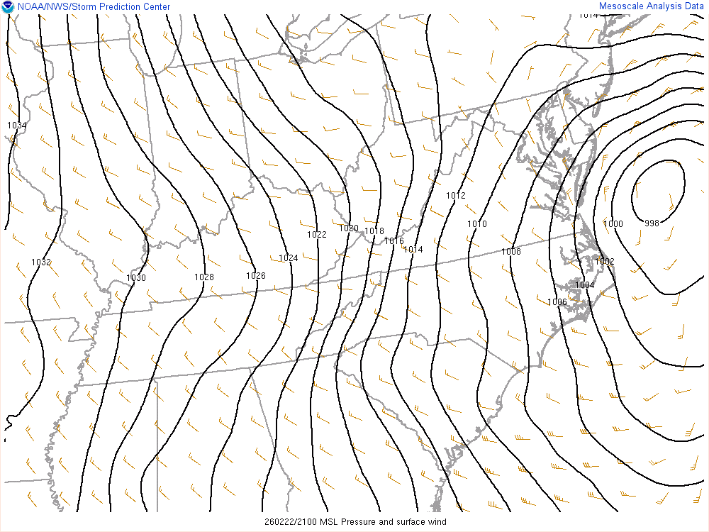

The Allsnow Blizzard of 2026
in New York City Metro
Posted
Happy looking image below