

SACRUS
-
Posts
13,080 -
Joined
-
Last visited
Content Type
Profiles
Blogs
Forums
American Weather
Media Demo
Store
Gallery
Posts posted by SACRUS
-
-
-
59 here at 11AM
-
3 minutes ago, LibertyBell said:
Yes these highs have been much weaker in the last few years than they were in the 90s when they overpowered the ocean.
Its all or more about the position center of the ridge, we have had record ridges in the past 10 years >600DM's.
-
You have to go back to 2015 for consecutive highs in the 60s for most of the board, that was the first week of Jue. June 2012 had a 3 day streak similar to this wthigh high near or below 70 around the same time.
-
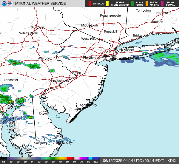
Spotty light rain on this chilly April morning
-
 1
1
-
-
2 minutes ago, LibertyBell said:
sounds a little like 1988 too.
No 100 degree days in any of those years in NYC or JFK (dont know about LGA.)
No 100 degree days at LGA in 1988, 1987 nor 1994
-
10 minutes ago, LibertyBell said:
sounds a lot like June 1994 (although June 1994 heat was more widespread). Why did the heat abruptly end after June in 1994, Tony? I saw that Philly still had a very high number of 90 degree days that entire summer (although it didn't match 1993 which was historic everywhere), but why did the heat end early in NYC that year?
I noticed that the records for today are from June 1994 (including a 101 at EWR?)
1994 continued hot through July and August was close to normal for those west of the City - similar to 2024 i assume where onshore prohibited the heat from extending into eastern sections
AT EWR there were 39 90 degree days. AT LGA 26 and NYC: 18
It also happened in 1987
-
 1
1
-
-
38 minutes ago, LibertyBell said:
last year *heat* didn't even register with me lol.
It has to be hot everywhere otherwise it's not real heat.
Was much more pronounced west of the city during that June heatwave where EWR and C/N NJ hit 90 (9 of 10 days) with maxes of 100, 97, 98,99, 98 so the folks west of there felt it.
-
34 minutes ago, LibertyBell said:
Does this indicate big heat for July too? In my experience we don't hit 100 in June (it has never happened here before and in NYC it hasn't happened since 1966), but I predict if we get to at least 95 in June we will definitely have multiple days over 100 in July.
You should preface that with Central park in NYC - LGA hit 100 in June in 2021 (6/30).
-
Thu night into Fri morning

-
22 minutes ago, bluewave said:
Yeah, the 500mb heights and 850mb temperature forecasts would suggest our first 100° of the season would be possible for the usual warm spots. But a wrinkle may be whether the ridge elongates too much into Canada. Notice how the models have a high over Canada and Bermuda. So there could be a subtle backdoor front nearby.
If the Bermuda High wins out than the first 100° for places like Newark could be possible. But it the high to the north is too strong, then more onshore flow in later runs east of NYC and perhaps the 100° potential over interior NJ.
We probably won’t know for sure until the period gets under 120 hrs out. But we should at least see mid 90s as a floor. And be could get closer to 100° if the ridge is flatter with more westerly flow.
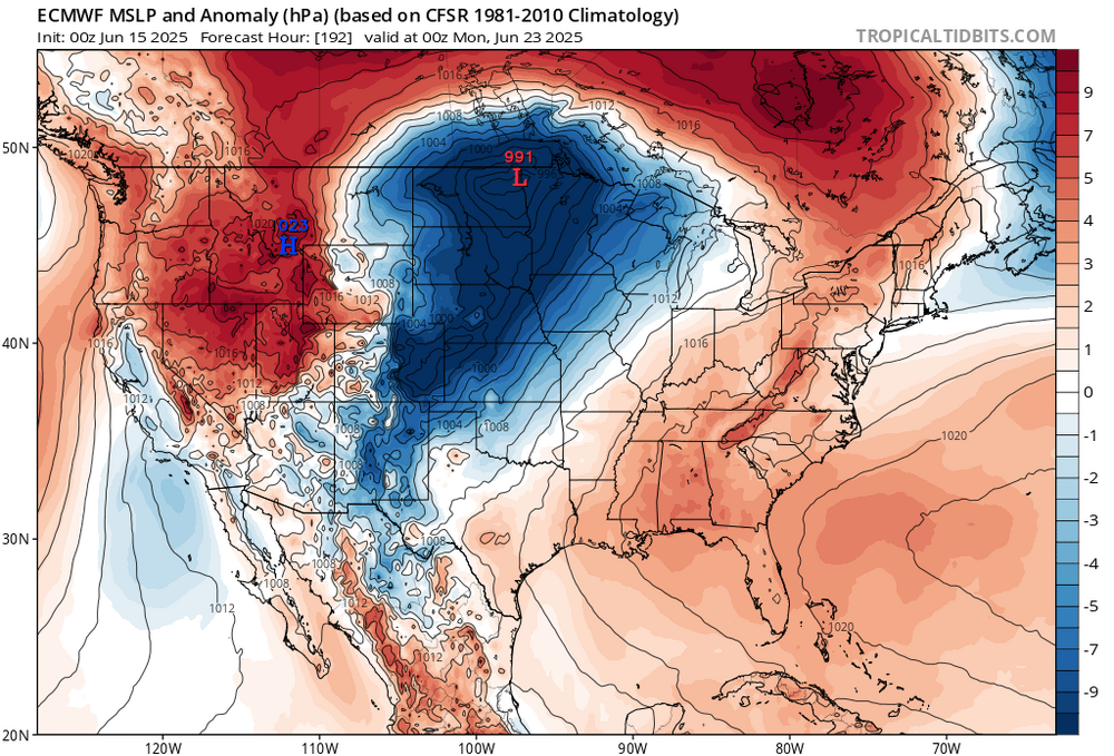
Astonishingly we had similar progression with the signal for the same period, last year which lead to the strong heat in NJ 6/20 - 6/27. The center of the ridge will be key as you detail if those east of NJ continue with the recent tendency for onshore or if its full blast westrlry
-
Euro is also in alignment
-
Records:
Highs:
EWR: 101 (1994)
NYC: 96 (1994)
LGA: 96 (1988)
JFK: 93 (1988)
Lows:
EWR: 48 (1933)
NYC: 48 (1933)
LGA: 54 (1951)
JFK: 51 (1965)
Historical:1662 - A fast was held at Salem MA with prayers for rain, and the Lord gave a speedy answer. (David Ludlum)
1879 - McKinney ND received 7.7 inches of rain in 24 hours, a state record. (The Weather Channel)
1884: Boston, Massachusetts recorded its highest pressure 30.57 inches of mercury for the month of June. (Ref. NOAA Boston Weather Events)
1896 - The temperature at Fort Mojave, CA, soared to 127 degrees, the hottest reading of record for June for the U.S. The low that day was 97 degrees. Morning lows of 100 degrees were reported on the 12th, 14th and 16th of the month. (The Weather Channel)
1940: A high temperature of 116° at Las Vegas, NV set their all-time hottest June reading. (Ref. Wilson Wx. History)
1953 - Dust devils are usually rather benign weather phenomena, however, two boys were injured by one near Prescott AZ. One of the boys suffered a black eye, and the other boy had two vertabrae fractured by wind-blown debris. (The Weather Channel)
1957 - East Saint Louis was deluged with 16.54 inches of rain in 24 hours, a record for the state of Illinois. (The Weather Channel)
1959: On this day Mt. Mansfield, near Stowe, Vermont, received four inches of snow. (The Farmer's Almanac)
1960: A heat burst struck Kopperl, TX, located about 50 miles southwest of Fort Worth from a dying thunderstorm. As the air sank, it warmed to around 140°. When the heat burst struck the ground, winds fanned out at over 75 mph. People had to wrap themselves in wet blankets to protect themselves from the heat. All crops were destroyed by the heat. (Ref. Wilson Wx. History)
1963: Heavy rain and hail raved parts of the northern Colorado Rockies. In southeast Denver, heavy rain flooded homes and streets. Hail to a depth of 4 inches on the ground stripped trees and drifted in to depths of 3 to 4 feet in places. Flood waters were as deep as 19 feet in places trapping many cars. Many creeks ran over their banks. A cell passed over Denver dropping 4 inches of rain in just 90 minutes. Damage totaled near a million dollars. (Ref. Wilson Wx. History)
1968: Severe thunderstorms brought heavy rain and high winds to much of the western two-thirds of Oklahoma. Winds gusting more than 70 mph dislodged a home from its foundation in Lawton, while winds stronger than 100 mph did extensive damage in Chickasha. The exact wind speed in Chickasha was not determined; because the wind gauge could only measure winds up to 100 mph. Torrential rain amounted to 7 inches in just a few hours near Loyal. (Ref. Wilson Wx. History)
1975: Carlisle, Tex.--An 11-year-old girl was burned to death in a fire caused by lightning. The lightning struck a window air conditioner and the home exploded into a blaze of fire. Another girl was injured. Plymouth, Ind.--Lightning killed a 55-year-old man as he was taking shelter under a pine tree on a golf course. (Ref. Lightning-The Underrated Killer.pdf)
1977: Heavy rains fell for two consecutive days across east central South Dakota through the 16th. Thunderstorms would develop and then move across the same areas repeatedly in what is called a train echo pattern. Rain amounts in the area included 6.9 inches at Watertown, 6.5 inches at Volga, and 7.5 inches at Bruce. (Ref. Wilson Wx. History)
1978: This was a rough day across portions of western and central South Dakota. A tornado touched down in Lemmon then skipped through town causing considerable damage. Numerous severe storms tore through central South Dakota with hail as large as baseballs and winds to 80 miles an hour causing $20 to $25 million dollars in damage across 15 counties. Several counties were declared disaster areas by the Governor of South Dakota. (Ref. Wilson Wx. History)
1986: 91 °F - Heart of June heat wave with 8 of first 16 days 90° or more in Washington, DC. (Ref. Washington Weather Records - KDCA)1987 - Thunderstorms developing along a cold front produced severe weather in the northwestern U.S. A tornado damaged five homes and destroyed a barn near Salmon ID. It lifted a metal shed 100 feet into the air, and deposited it 100 yards away. Hail an inch and a half in diameter caused ten million dollars damage to automobiles at Nampa ID. (The National Weather Channel) (Storm Data)
1988 - Severe thunderstorms in the Central High Plains Region spawned five tornadoes around Denver, CO, in just one hour. A strong (F-3) tornado in southern Denver injured seven persons and caused ten million dollars damage. Twenty-six cities in the eastern U.S. reported record high temperatures for the date. The high of 97 degrees at Portland ME was a record for June. (Storm Data) (The National Weather Summary)
1989 - Thunderstorms produced severe weather over the Southern and Middle Atlantic Coast States. The thunderstorms spawned eight tornadoes, including strong (F-3) tornadoes which injured three persons at Mountville PA and four persons at Columbia, PA. There were 111 reports of large hail and damaging winds, including wind gusts to 80 mph at Norfolk, VA, and Hogback Mountain, SC. (The National Weather Summary) (Storm Data)
1989: A late-season frost occurred over parts of the Midwest. Scattered areas of frost caused considerable damage to the corn crop in low-lying areas across northern Iowa. Damage was estimated to be around $2 million dollars. The hardest hit counties were in Winnebago, Kosuth and Hancock Counties. (Ref. Wilson Wx. History)
1991: The second largest volcanic eruption of the 20th Century began as Mt. Pinatubo injected 15 to 30 million tons of sulfur dioxide 100,000 feet into the atmosphere. 343 people were killed in the Philippines as a result of the eruptions, and 200,000 were left homeless. Material from the explosion would spread around the globe, leading to climate changes worldwide as the sun's energy was blocked out and global temperatures cooled by as much as one degree Fahrenheit. 1992 was globally one of the coldest since the 1970s.
-
59 / 56 cloudy and cool. 48 more hours in the muck with mainly light showers/rain amounting to another 0.25 at most. Clears out later on Tuesday now and that day looks lost to cooler/cloudy conditions through most the afternoon. By Wed sun returns and it should quickly warm as front comes back north it could trigger scattered storms later Wed. Thu first (2nd/3rd) 90s for many with surge of heat, additional showers/storms Thu night possible. Heat builds north and east by the 20th and into the weed of the 22nd and beyond.
6/14 - 6/17 : Cloudy cool
6/18 - 6/19: warm up (90s on Thu) storms possibility each day in the pm/evening
6/20 - Beyond : Heat builds in - sustained ridging into the eastClouds magnet has reloaded not much in the way of breaks or poked of sun today

-
Jun 10 2019 last June high in the 60s for most.
Today's Highs
ACY: 71
PHL: 70
EWR: 70
TEB: 69
NYC: 67
New Brnswck: 67
LGA: 67
TTN: 67
JFK: 66
BLM: 66
ISP: 63-
1
-
-
We'll see if the Western and pushing into CPA breaks in the clouds make it this way and we see some pokes of sun tomorrow and maybe get us above forecasted crumby highs
-
Mod - heavy rain and 0.63 in the bucket.
-
3 minutes ago, winterwarlock said:
4 weekends out of 15 summer weekends flushed down the drain
The loss of money of the beach businesses losing 9 days so far has to be enormous
Last dry / warm and sunny weekend day was May 17th
-
2
-
-
Moderate rain into CNJ with heavier rain in EPA
-
The next week is spotty rains Sat-Mon then some overnight showers storms Wed- and scattered storms Thu-FRi,

-
 1
1
-
-
Only saving grace is while cool and cloudy we should avoid the heaviest rains these next 72 hours.
-
1
-
-
Records:
Highs:
EWR: 99 (1988)
NYC: 99 (1956)
LGA: 99 (1956)
JFK: 95 (2005)
Lows:
EWR: 49 (1978)
NYC: 49 (1875)
LGA: 51 (1978)
JFK: 52 (1980)
HIstorical:1886: Many people were lost when high seas from a hurricane inundated the area near Sabine, TX. (Ref. Wilson Wx. History)
1903 - The Heppner Disaster occurred in Oregon. A cloudburst in the hills sent a flood down Willow Creek, and a twenty foot wall of water swept away a third of the town in minutes, killing 236 residents and causing 100 million dollars damage. (David Ludlum)
1953: The warmest June on record occurred in Oklahoma City, OK. The main part of the heat wave extended from the 11th through the 21st, and seven of the daily high temperatures during that stretch remain records for their respective dates. June 14th was the hottest day, reaching a toasty 106°. The other records ranged from 100° to 105°. Even the nighttime lows were records. Eight daily minimum temperatures from June 1953 are still record-warm daily minimum temperatures, ranging from 75° to 80°. (Ref. Wilson Wx. History)
1957: An F4 tornado moved across the south and southeast sides of Springfield, IL. The tornado destroyed 25 homes and severely damaged 175 others; property damage was around $3 million dollars. On the north side of town, the storms produced a wind gust of 98 mph at Capital Airport, which still stands as Springfield's record wind speed. Two people died during the storm, with over 50 others injured. A separate tornado touched down in downtown Jacksonville, destroying or damaging 40 buildings. East St. Louis, IL recorded the state record for rainfall in 24 hours with 16.54 inches. (Ref. Wilson Wx. History)
1961 - The temperature in Downtown San Francisco, CA, soared to 106 degrees to establish an all-time record for that location. (The Weather Channel)
1974: A tornado took an intermittent 53 mile long path across northwest and west central Illinois. The tornado first touched down just southeast of the Quad Cities, and moved southeast into Knox County. In Abingdon, 200 homes were damaged or destroyed. (Ref. Wilson Wx. History)1987 - Thirty-two cities in the central U.S. reported record high temperatures for the date. The high of 97 degrees at Flint, MI, tied their record for June, and the high of 101 at Milwaukee WI marked their first 100 degree reading in 32 years. Thunderstorms brought much needed rains to South Texas, drenching McAllen with 3.2 inches in one hour. A thunderstorm soaked the town of Uncertain with 2.3 inches of rain in one hour. (The National Weather Summary)
1988 - Thirty cities in the eastern U.S. reported record high temperatures for the date. (The National Weather Summary)
1989 - Thunderstorms developing ahead of a cold front produced severe weather from the Central Gulf States to the Middle Atlantic Coast Region during the day and into the night. There were 62 reports of large hail and damaging winds. Thunderstorm winds caused 28 million dollars damage in Montgomery County MD. (Storm Data) (The National Weather Summary)
1990: Shadyside, OH was destroyed by a wall of water up to 30 feet high causing 26 fatalities. The flooding was caused by 4 inches of rain that fell in just 75 minutes. Localized, excessive rainfall fell on saturated ground over southeastern Ohio during the evening, resulting in a 15 to 20 foot wall of water that raced down three small tributaries of the Ohio River. (Ref. Wilson Wx. History)
1994: Norfolk: a bolt of lightning struck and critically injured a 50-year-old woman and a 38-year-old man playing in a golf tournament at Greenbrier Country Club in . Both suffered severe burns.
1998: On June13th and 14th Boston, MA had 5.99 inches precipitation the greatest in a 24 hours for June. (Ref. NOAA Boston Weather Events) and Atlantic, Iowa, set a state record for daily precipitation, measuring 13.18 inches of rain. (Ref. Wilson Wx. History)
2010: During June 14, training thunderstorms associated with a nearly-stationary cold front and an intense low-level jet brought torrential rains to the Oklahoma City, Oklahoma, area. Six to nine inches of rain in little more than three hours caused flash floods, resulting in more than three dozen water rescues. The North Canadian River at Oklahoma City rose from eight feet to over 21 feet almost instantly during the morning of June 14, Oklahoma City's wettest day on record (7.62 inches). -
64 / 59 light rain. Kinds of luck yesterday going partly sunny as the next 72 hours starting today look like Ireland - coold cloudy and spotty rain / drizzle. Heaviest rains stay south and today looks the wettest of the next 3. Highs near or below 70 each of the 3 days. Clear out and warm up by Tuesday. 80s by Wed and next shot at 90 by Thu with continued storm chances. Het builds out of the west to the north and east by the 20th with shot of a much hotter pattern especially inland from there and beyond.
6/14 - 6/16: Cool / cloudy wet around 0.5 for most
6/17 - 6/19: Warmer / still chance of shower/storms
6/20 - beyond : Heat builds north and east / Overall warm-hot and wet-
2
-
-
Today's Highs
PHL: 83
TEB: 81
EWR: 81
JFK: 79
New Brnswck: 79
NYC: 78
ACY: 78
ISP: 77
LGA: 77
TTN: 77
BLM: 74

June 2025 discussion-obs: Summerlike
in New York City Metro
Posted
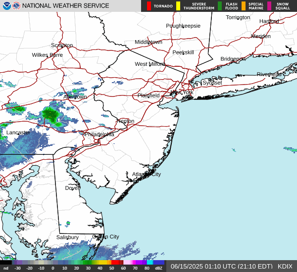
Light rain moving through the same areas as yesterday 0.22 in the bucket today (so far) total from the ugliness is 0.84