

CaryWx
-
Posts
2,667 -
Joined
-
Last visited
Content Type
Profiles
Blogs
Forums
American Weather
Media Demo
Store
Gallery
Posts posted by CaryWx
-
-
Queencity, Might I impose for the RDU numbers?
")
-
 1
1
-
-
10 minutes ago, Orangeburgwx said:
Welcome back Grit
Well, he does have a day job.
")
-
6 minutes ago, ILMRoss said:
Raleigh will be in the running for 1-3 inches of front end thump before switching to... something else. Learn from the NE from that mid Nov storm... that front end thump can stymie even the most experienced models and forecasters, especially with a solid CAD in place. Might not happen, but I’d keep an eye on that possibility. Lastly, I would not make any absolute statements about surface temps until we’ve seen a few cycles of the nam, raleigh still firmly capable of a significant sleet/ice event in my opinion
Thanks for the fresh update. As I recall front end thumps don't work out so well for our area usually. Back to the sw piedmont usually has better luck. The moisture always seem to get here too late and not before the nose
-
16 minutes ago, wake4est said:
The NAM is primed to bring a fat juicy storm to the SE when it gets in range...
Not so much for us I think
-
Well, sounds like Wake county is bowing out of the game.
-
1
-
 1
1
-
-
11 minutes ago, Cold Rain said:
Awesome. Thanks! Yep, sucks for us. But pretty typical.
I see a nasty warm nose there, literally
-
 2
2
-
-
1 minute ago, griteater said:
It's hard to beat the ewall 4 panel...I wish other vendors would go to that with the Euro etc.
The 12z UKMet goes big with the phase but still keeps the storm to the south, moving off Jacksonville roughly...similar to GFS really...it's a late, but big phase
J'ville, NC or J'ville FL?
-
It's close for Cary. Is that CAD eroding? If so this will not amount to much. If it holds could be a decent event.
-
1 minute ago, jjwxman said:
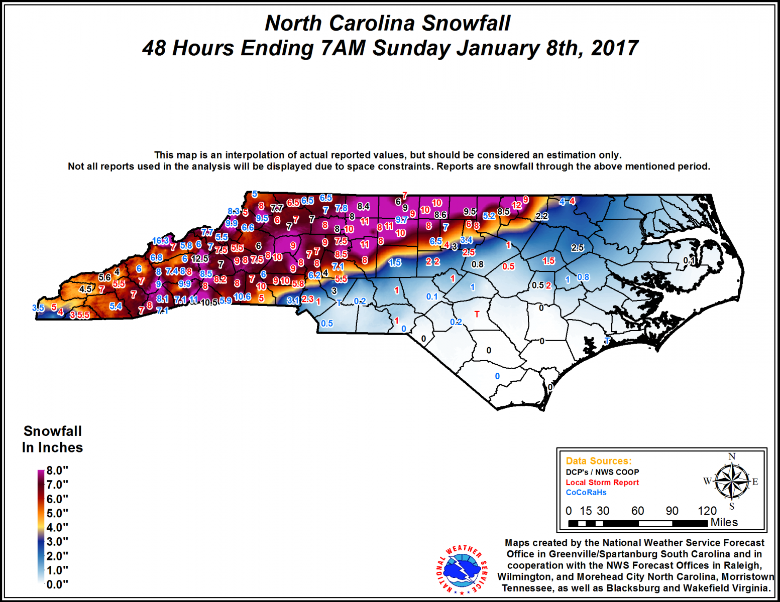
The HRRR also nailed the warm nose in that Jan 2017 system.
-
1 minute ago, WidreMann said:
This is as silly as the Euro, albeit in a different direction. The number 18 may be relevant for RDU, but I guarantee you it won't be with regards to inches of snow fallen.
Come on Widre. You know better than to take these numbers literally. Cut them in half and still don't expect that much. Bottom line is we may get a little sleet/snow in theTriangle if this keeps up. Maybe more.
-
The GFS LP is not in the best of places (MB, SC) for the Triangle
-
1
-
-
59 minutes ago, BornAgain13 said:
I know we are still far out folks, but what is almost certain is, that their will be a storm. Nailing down the specifics will be interesting as we get closer.
I agree with BornAgain. We have a storm. Details to come
-
 1
1
-
-
51 minutes ago, Jonathan said:
So, our elusive Modoki Nino is off the table. That is pretty much set. Now I'm reading the Nino itself is basin-wide and now getting into moderate to possibly strong territory? Is that correct? If so, that is a MAJOR bummer for us.
Also, look at all these cutters with the "OMGOMGOMG WE GOTTA HAVE -NAO FOR SNOW IN THE SOUTH". We should all now learn that a -NAO isn't as important as the +PNA/-EPO combination. The Pacific RUINS cold patterns in the east way, way more than the Atlantic does.
I'm not seeing all that just yet.
-
48 minutes ago, Orangeburgwx said:
I second this
Too strong of a block leads to extremely suppressed tracks (too far off the coast). The block breakdown is like a rubber band settling back in place, gives us a better chance, but at the same time if it relaxes TOO much the low comes too far inland. It is all about timing, all we can do is watch, wait, and pray.
Correct. Bob Chill has presented good commentary on this in the past.
Can also be good for snow on the front end of blocking but seems to line up better for our area when it either relaxes or flexes.
Prefer just enough flex to throw copious moisture into advecting (is that a word?
) cold air though.
-
1
-
-
That gets me all jiggly inside
-
2
-
-
Oh yeah this is gonna go up the flagpole

-
Nice work Grit. Look forward to your posts as this winter unfolds
-
1
-
-
Come on Orange we're likely not getting snow but may need to open the fireplace sooner than expected.
-
 1
1
-
-
6 hours ago, Orangeburgwx said:
Chance it snows on Christmas day I see not snow on the ground which is a much higher percentage.....well, north of my location anyway
-
We need whatever we can get Falls to kill these 'skeeters.
-
I still have powe
-
1
-
-
15 minutes ago, fountainguy97 said:
It has before but no. That is the same time each image. Its the HRRR trend not a progressive run. So instead of 991mb the HRRR shows 989 at the same hour.
Darn it! Should have caught that and did not pay attention.
Going to have my coffee now.
-
1
-
-
Intensifying and dropping 3 clicks to a 989? Is this really going to happen over land?
-
Wondering if the gusts will be more like straight line winds with the fropa as the storm pivots out of the region
December 8-10, 2018 Winter Storm
in Southeastern States
Posted
Thanks Falls and Queencity.
CantralNC, After January 2017 I'm all conditioned for this one to have the sharp cutoff west of my location")