

CaryWx
-
Posts
2,667 -
Joined
-
Last visited
Content Type
Profiles
Blogs
Forums
American Weather
Media Demo
Store
Gallery
Posts posted by CaryWx
-
-
16 minutes ago, Jet Stream Rider said:
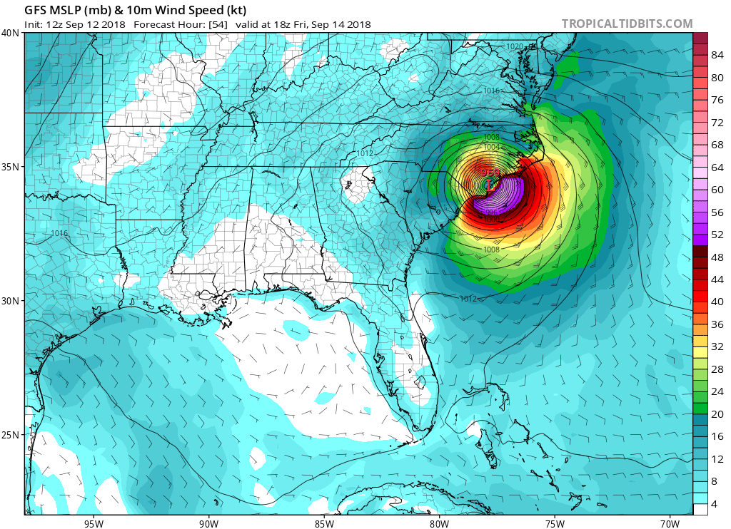
12z GFS makes landfall on Friday vicinity of Wrightsville Beach. That is far enough north to cause some power outages in parts of central and eastern NC especially downeast NC and the sandhills. Raleigh will feel it in this position. Don't let your guard down, Florence is an impressively strong storm and obviously very dangerous.
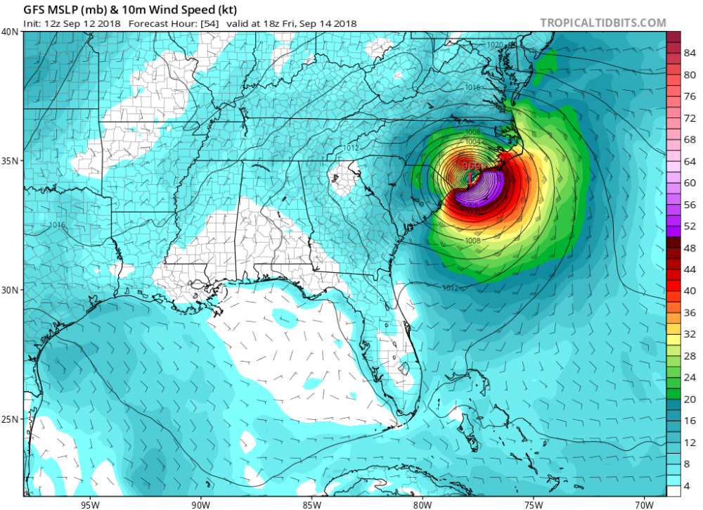
If the GFS is to be believed. Right now I'm not model hugging anymore like I was. Just too many solutions. Following the NHC products for about another 24hrs or until better consensus
-
 1
1
-
-
We get an update from the NHC at 11am ET right?
-
Any chance this continues to maybe move south for landfall? Maybe down at MB?
-
2 minutes ago, Justicebork said:
NAM - Florence stalls out east of Wilmington at 42 and refuses to budge for the rest of the run. There will be moisture.
So you're telling me I should put the top up on the convertible?
-
 2
2
-
-
3 minutes ago, wncsnow said:
A lot less rain. Less than 2 inches for most. A little more towards 95. Very little wind as well.
Wish I could believe that but this route is still tough for the Triangle. Not catastrophic though
-
13 minutes ago, Regan said:
Glad to see less rain for Raleigh. Glad to see the winds will be lots better. So far anyway. I guess because they think she will dispense herself on the coastal counties.
Selfishly we want to be as far sw of the eye & eyewall as we can. Having this projected to pass anywhere south of the triangle in my opinion is not good. Doubt it is going across SC so anywhere north of there is just too close.
-
3
-
-
Is it me or has the path shifted more NW and east once on shore?
-
1 minute ago, downeastnc said:
you would expect to see the NHC track at 5pm to not move or shift a tad bit north....I would also expect the inland plots to come east a bit....
That's what I'm expecting. (assuming you meant "now" instead of "not") Hoping the Triangle ends up west of the eyewall in future runs but know that puts you more in the worst zone.
-
skeptical on these 20"-30" numbers unless doesn't move out of here.
-
1
-
-
Just to further echo Jet Stream Rider's post.
I was in Cary, NC for Fran (c1996) and without power for 5 days plus had three trees on my house. This path, if to be believed, will rock not only the coastal plan but a great deal of the piedmont as well. I would take the initial steps for preparedness starting no later than Monday. It's projected landfall timetable has now raced ahead 12hrs. With Fran I was already without power when the eye came ashore 120 miles away.
-
1
-
-
WWAs just went up or Durham and Orange counties in NC
-
yowzers!
....but it is the ICON
-
Dammit! I had shut down until Dec. What's all this crap
-
1
-
-
That's swanky looking---wish it were about a month earlier
-
Huh...what---Who woke me? Thought it was Spring.
How's this looking for the Triangle
-
some potential here boys with 5-6th and I just dropped per-emergent today Go figure
-
An 18th storm maybe??
-
Giving this until week of Feb 19th-25th or so, but we should start seeing something on the 10 day maps this weekend I would think/hope.
-
I'm showing rain on my mobile weather app from Sat straight thru Thurs next week. Are we going to have a system stall or something?
-
1 minute ago, jburns said:
A thousand year event and two-thirds of this forum think we are overdue.
I've turned off the lights, shut my eyes and just can't see March 1960. I would make it happen if I could.
")
-
Looks like this [model name] run initialized incorrectly.
Wait until the wave gets onshore.
-
1
-
-
9 minutes ago, tramadoc said:12 minutes ago, CaryWx said:What, no bass?
Heck no. Well, maybe Chilean Sea Bass.
agitated sea bass?
-
1
-
-
Going to give this winter about another 10 days of modeling.
If it projects out from there like it is projecting out now 'bout ready to call it a season folks.
It indeed is close to pre-emergent time for sure
-
On 2/1/2018 at 8:52 AM, tramadoc said:
Flounder, Grouper, Mahi Mahi, Tuna, Snapper, Trout, or Cod. That's the only fish I will eat. Not eating a bottom feeder.
What, no bass?
Hurricane Florence
in Southeastern States
Posted
Honestly? Following WRAL attm. Winds gusting to 43mph at peak time. No real clear indication on precip amts. Thinking way more than 2-3 inches. 5-7 inches more likely and maybe up to 8 inches of rain. This thing is big and a slow mover so lots of water over an extended period of time is a bad combination.