

CaryWx
-
Posts
2,832 -
Joined
-
Last visited
Content Type
Profiles
Blogs
Forums
American Weather
Media Demo
Store
Gallery
Everything posted by CaryWx
-
Yes, right now Christmas looks rainy
-
Looks to be a little faster than originally projected. At least from my radar Obs
-
Well I have to be totally transparent. Just a weakness of mine. We are both correct depending on how you read this. Just the NWS. What do they know.
-
-
Found this but believe it was mostly sleet.
-
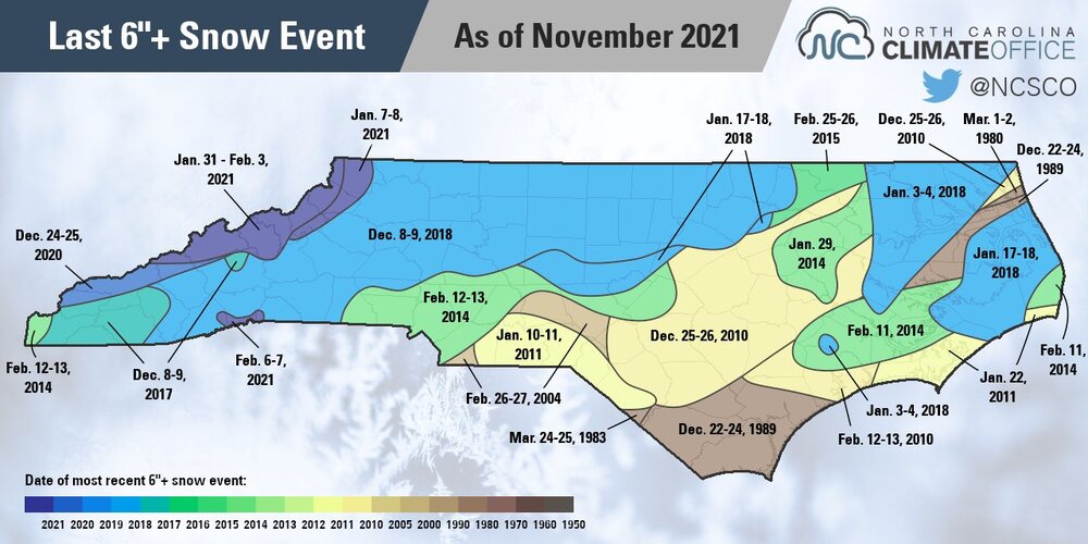
Yes, but I've not seen even 4 since early Dec 2018.
-
Decent measurable? Like warning criteria (~4")? Don't think we've sniffed that
-
Don't think I've seen a decent measurable snow in Cary since early Dec '18. That's five yrs now.
-
Kind of a wonky shift to me. Still not resolved imho
-
oy
-
tor?
-
Well it's not even astro winter yet and we are only at 35N so my expectations aren't there yet. I do get your larger point though No cold in sight, anywhere, is worse than our usual 'delayed' winter at this point.
-
Maybe I'm reading this incorrectly but I see a projection out to the 23rd and certainly while in the CoD is still in phase 7. How is this a 5-6 regime forecast?
-
-
No worries. The coming winter STJ will solve our problems
-
Also from NWS... Winter Forecasting Tools: Here’s What’s New at NOAA this Year This winter, NOAA will implement a series of upgrades and improvements. In November, the experimental Probabilistic Winter Storm Severity Index (PWSSI) will become operational. The product will enhance communication with external partners, media, and the general public by graphically depicting the likelihood of potential societal impacts due to expected winter hazards over a 7-day period. This is complemented by a version of the Winter Storm Severity Index (WSSI) based on the official National Weather Service forecast of the most likely conditions over the next three days. NOAA’s Weather Prediction and Climate Prediction Centers will continue to use Winter Key Messages, which highlight the agency’s most essential information for upcoming winter weather, including extreme cold and heavy snow potential. These can be found under “Top Stories” on the Weather Prediction Center’s and Climate Prediction Center’s websites. This winter, NOAA will complete its implementation of Impact-Based Warning Tags for Snow Squall Warnings. Snow Squall Warnings are warnings issued for short duration intense bursts of snow and wind leading to whiteout visibility and possible flash freezes on roads. To distinguish high-impact snow squalls, the National Weather Service will issue impact-based Snow Squall Warnings using the “Significant” tag for events that pose a substantial threat to safe travel. Wireless Emergency Alerts, which are emergency messages sent by authorized government alerting authorities through wireless carriers, will be limited to only high-impact Snow Squall Warnings with the Snow Squall Impact Tag of “Significant.”
-
https://www.climate.gov/news-features/understanding-climate/2023-24-us-winter-outlook-wetter-south-warmer-north
-
That plus the Vancoverish ridge and western Alaskan trough
-
Skeptical right now that midwest blast makes it into the southeast but we'll feel some effects east of the apps.
-
I think we need to give NWS a little room here. A bit premature
-
96.7? Don't think it hit that in my neck of the woods
-
Ryan Hall is not really calling for a strong nino this year but it's still early.
-
What's a good Nino signal for next year for the southeast? I think no more than moderate. Maybe 1.5-1.75?? Asking the experts. Thanks
-
If that ULL at 500 on the 18z gfs could just get some intensity going we'd have good storm


