michsnowfreak
-
Posts
17,980 -
Joined
-
Last visited
Content Type
Profiles
Blogs
Forums
American Weather
Media Demo
Store
Gallery
Everything posted by michsnowfreak
-
Definitely had less than here but perhaps 1.5 is a bit low. Not sure. Ann Arbor had 1.6", DTW 3.0", Wyandotte 3.3", Monroe 4.0". Possibly near 6-7" right at the state line. 2 day totals Feb 2-3 Garden City- 7.7" Ann Arbor - 7.8" (6.2+1.6) DTW - 9.2" (6.2+3.0) Wyandotte- 9.3" (6.0+3.3) Carelton - 10.0" Monroe - 10.2" Toledo - 12.7" (4.3+8.4)
-
Nice. I Picked up 3.2" today as of 10:30 PM and still snowing. This is on top of yesterday's 6.0", so 9.2" between the 2 days. Deep Winter outside. Report out of Monroe of 4" today and 6" yesterday
-
Actually with today's over performance DTW has had an 8+ storm (2 waves but seems everyone is considering 1 storm). Just off the top of my head, Chicago, Milwaukee, Albany have not had a 6"+ storm yet.
-
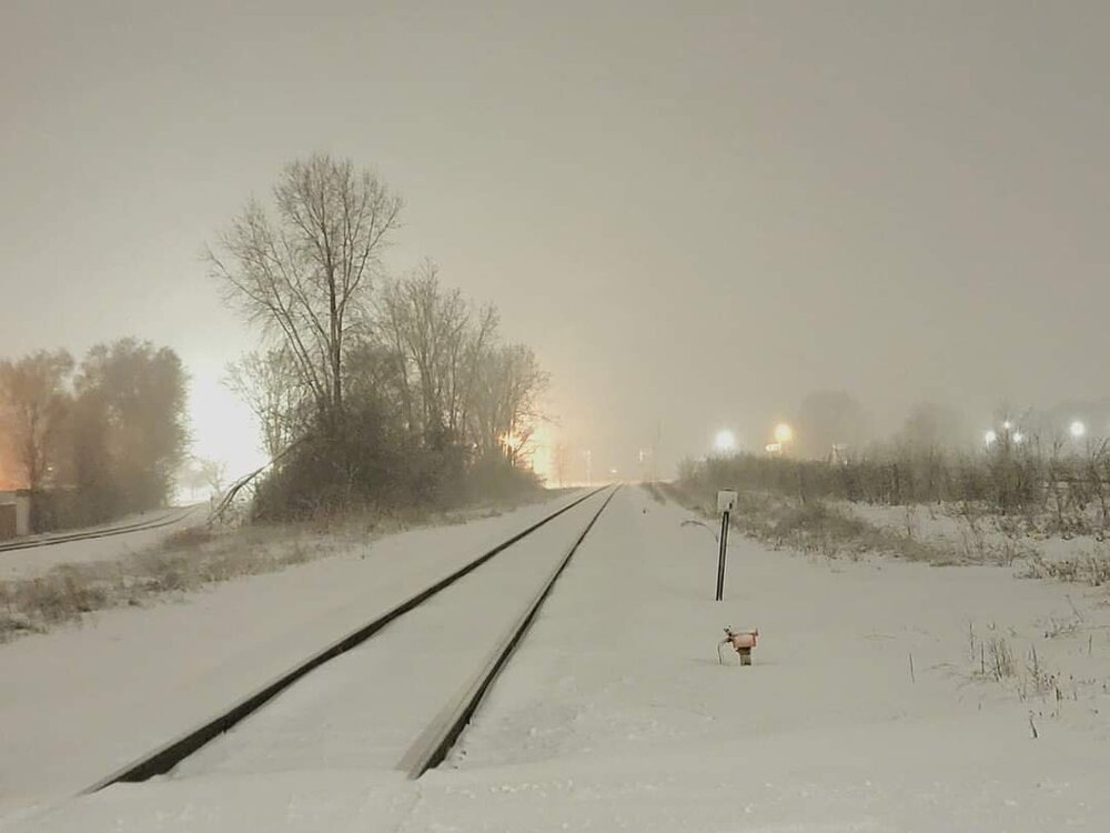
Measuring very hard today. My snowboard had 4" on it but I'm accounting drifting for that. I have a big driveway and I took a ton of measurements, ranges from 1-5 and going with 2.6 so far and still snowing and blowing. Visibility has been half mile most of the afternoon. Today's drifty snow covers up the massive frozen chunky snowbanks with a marshmallow look. Top notch winter scenery. Should end up with 9 to 10" between the 2 waves.
-
You mean 8 between yesterday or 8 just today?
-
I'm glad I had the driveway clear because the snowboard is useless it's so drifty. But it does seem to be already be approaching 2", we should be able to easily see 3" today
-
Guess today's storm really did trend Northwest as well. For the radar the snow line goes all the way back to Lansing and right now DTW is at 0.5 mile visibility. Frustrations of the storm aside it's a very classic Winter day outside right now. Edit- Very surprised at how today is over performing. Just stepped outside for a minute and there's probably about 1.5 already, did not officially measure though. Will easily exceed 8 for the 2 day total
-
Chicago got 5.6". And actually, DTW very well may eclipse 8" since todays wave moved farther Northwest. I mean yeah it's 2 waves and I don't consider them the same event but that's what everyone was tracking the whole time. I'm surprised you are actually lowering the bar to 8", which Detroit has actually had more of than many of the cities you just listed, in the past 5 years. I thought you only cared if it was 18"+ otherwise you wanted 85 and Sunny. This storm was a nw trending, warm tongue, cement snow, flash freeze bust, but you know darn well Detroit has no problem typically getting 8 to 12" snow storms. It's eclipsing the foot that is that is like pulling teeth and the ironic thing about 2015 is that the jackpot zone actually lined up around the DTW corridor. The storm itself, while a good one, was not as fierce as the 1 the year before, but in that 2014 storm DTW only saw 11" while other areas saw 15 or 16".
-
Snowy, blowy and drifty. Today will definitely be over performing.
-
Records fell like domino's in 2013-14. But in terms of snowSTORM records, we just had the 3rd largest snowstorm in 2015. I foresee us eventually knocking over 2nd place, the 1974 storm, but I really doubt we ever touch the 1886 storm. Which was in April of all things. I really doubt you will ever surpass the 1967 or 1978 storm either, but you should be able to make a run at your 3rd.
-
I imagine down there in open areas ot is bad. It's snowing and blowing all over the place here. Some roads are still treacherous even where plowed.
-
I did my driveway and my mom's. It was OK but had to run the snow blower over multiple times because of the icy layer. Plow piles are quite impressive due to the water content. Today is a beautiful Winter day with snow falling and blowing. Should tack on a few inches of powder.
-
Monroe had 5 to 6" and they could easily get another 3" today. Not out of the question for them to hit 10" in total lol. And pixie dust my ass, after that cement we dealt with this deserves to come in as pure fluff lol.
-
Sheets of ice where the snow has been cleared. Definitely treacherous going. 6" of snow fell but would have been 10" if the vaunted kuchera ratios panned out. Looking like today's wave will give us some snow as well, fingers crossed.
-
Not sure but if that's the case you definitely were in some sort of screw hole. Depth here is 5-6 and as said you don't even touch ground when walking on it lol. Most reports coming in are around 6" give or take a few tenths. I'm being lazy so I haven't thawed out my rain gauge yet but I'm definitely interested to see what the total liquid equivalent was. It will be easy to figure out because there was 0.10" of rain ahead of the switch to snow so I will be able to just subtract the 0.10 from the total. 1st order of business tho is to get this stuff cleared. This should be a very interesting task lol. 6z models inched North with some snow today. DTW 6.2, ARB 6.2", FNT 11.0", MBS 4.5"
-
We were a tad less than that at 1230. It was like an April snow, complete with a few hours of SN+ obs at DTW that just couldn't stack up, but then it definitely started adding up into a solid concrete slab as the afternoon wore on then took on a legit snowstorm feel by evening as temps fell and snow was blowing and drifting.
-
Picked up over 2" of powder after 7pm. It will be interesting to see what the total liquid equivalent of the snow was when I thaw out my rain gauge
-
You only got 4"? There was a time late this afternoon when you were supposedly between banding, but without an accurate radar who knows. 6" More or less here to Monroe
-
Frustrations with THIS storm aside, we've certainly been doing better than Saginaw with snow storms on the whole the past many years. Flint or Fenton definitely would be a better option storm wise haha.
-
Got 6.0" here, the top drifted and fluffed up nicely to give it that "marshmallow" look but the bottom is unreal. You don't even hit ground when walking on it (and I'm a big guy). Definitely a solid snow base. Will be interesting to see how hard it gets as temp continues to drop. Low 20s now.
-
The total snow from this system is definitely a disappointment, but the real lesson is don't get so caught up in kuchera snowmaps without looking at other factors (in this case warm nose). Obviously the QPF was overdone in this case, but I have noticed that many of the times that we either over or under perform it is tied to ratios. I probably had more liquid in this snowfall than I had in last February's 11" powder snowfall.
-
I hear lots of people's are clogging. That damn warm nose screwed us with ungodly low ratios. The heavy wet snow fell all day at quarter to half mile visibility and we struggled, now this evening it's stacking much faster. Glad we are fluffing up some tonight.
-
At least we're making a nice evening run of a snowy blowing night. The concrete blanket of snow that fell earlier is no joke. I hope my snowblower doesn't clog because it's a heart attack waiting to happen. I can honestly say I've never walked in more dense snow. An hour ago near 5", maybe closing in on 6" now. The first 3.5" or so were less than 5-1 ratio.
-
Moderate to heavy snow all afternoon at DTW yet we have about 2.5" of the lowest ratio cement I can recall. Prob 5-1 ratio. Wind picking up, temp dropping, finally should turn powdery. Roads a disaster of glued slush starting to freeze. Watch that warm nose toronto folks. It sucks.
-
Let's go