

pasnownut
-
Posts
9,002 -
Joined
-
Last visited
Content Type
Profiles
Blogs
Forums
American Weather
Media Demo
Store
Gallery
Posts posted by pasnownut
-
-
was out on snowmobiles w/ son tonight. Basically burnt some OLD gas out and put some fresh in for weekend.
First time in almost 2 years since we've been able to ride down here. Was bony as hell in plowed fields, but hoping we take care of that this weekend. Decent amount of other tracks, so I guess we weren't the only ones anxious to ride. Have fun model watchin all, I'm headed to bed.
-
 1
1
-
-
54 minutes ago, mitchnick said:
Based purely on the Nam, this is really close to something bigger. 4-6 hour difference between this and a general 6-10" event for many imho.
looks notably better wrt spacing and qpf field. Crowd pleaser for many (of course w/ normal adjustments made to said model bias)
-
2 hours ago, Blizzard of 93 said:
18z Euro had its best run since a couple of days ago.
after reading the last few pages, I will giggle my ass off if this starts to moisten up as often IS the case as we get closer and we get back into 2-4".
Most of us know how things roll and know that EVERY map has a degree of bias/adjustment needed when viewing. Didnt think this needed said after doing this for as long as we have.
I'm assuming you know better as well . If not, catch up...
")
-
 1
1
-
-
9 minutes ago, mitchnick said:
18z HRRR pretty good starting 10 miles north of me....lol
Still around 2.5" here, but some 4"+ to the north.
IF that verifies, the only ones that wouldnt approve would be the plain clothes snowmobilers from Quarryville that were jackpotted this morning

-
5 minutes ago, Itstrainingtime said:
I posted CTP's map last evening for the Friday event - looks like they've ADDED 1" to their new map:
looks like they followed a few of our
forecasts....i mean guesses.-
1
-
-
btw, one of "our" guys is coming back from a break on the board. I'll let you figure out who....
I promised him that most of the crap that's been going on recently seems to have subsided and that trolls seem to have crawled back into their caves. Of course good "outsiders" ARE ALWAYS WELCOME.
Hoping we keep it that way.
Heres to HH not shartin the bed any further and keeping our 1-3 safely in play so we can all enjoy a winter weekend.
-
2
-
 3
3
-
-
6 minutes ago, paweather said:
Well we got a good bit of winter out of it whatever they are counting and more to come.
and an upcoming period of neg departures to subtract from the "ugly". Like you I'll enjoy the current winter and will worry about ugly later, and with a few beers, it may not look so bad after all...:).
-
1
-
-
56 minutes ago, mitchnick said:
We're at a peak in the solar cycle, which adds to the sun's heating efficiency.
and dont forget that for where its melting on the roads, there's this thingy called brine...
-
1
-
-
Just now, mitchnick said:
SSW events are not voodoo. They really do occur. Predicting the results, if any, of SSW events to the weather at any particular location(s) is voodoo imho.
Agreed pal. I'm guessing the numbers guys just look at the odds and say....meh.
IF we keep the PNA + that could at least offset less than stellar looks from other tellies like NAO etc.
-
1
-
-
3 minutes ago, Superstorm said:
Doing think we see a couple days in the 50s.
yeah, we seem to overachieve wrt how well we warm, so I'd not want to wager any bets w/ you. While 850s start to warm about a week from now, 2m temps hold on a little longer to respond. The realist in me says that I'll take a week of white and be fine w/ a relax. I'd think many here would as well.
-
and lastly, if one looks at 2m temps (looking at GFS), it looks like we stay in 30's through mid next week. If you add 5 on, low 40's will feel nice for a few days, till we ease back into colder stuff into last week of Jan. As long as we keep the torches at bay...alright by me. Could get close a couple days, but it happens.
-
10 minutes ago, Rd9108 said:
Even if that doesn't materialize you still have the MJO going into favorable phases once it gets out of phase 7. So there should be chances for all of us unlike last year.
Yeah after we Jan thaw, it looks decent as of now. Lets hope momentum builds for a quick relax/reload.
-
1
-
-
11 minutes ago, mitchnick said:
Sudden Stratospheric Warming event ocurring today. No guarantees the cold comes on our side of the Pole, but if it does, February into March will be sweet and white. Normally takes 15-20 days on average before we see it translate to the troposphere, so we'll know then who the winter benefactors in the Northern Hemisphere are. Keep your fingers crossed...eyes too if you want to make driving fun.
I'm glad YOU brought it up, as when I've done it over they years, I get plenty of flack for discussing such weather voodo. Hoping your comments are better than mine. That lag time could work well w/ other tellies as we turn the page into our best month for snow.
-
Quarryville plain clothes snowmobile crowd approves of this map. All i got for ya...

-
1
-
-
CMC is no longer a GEM to look at as it depicts my last statement. Spacing too far and qpf responds. Snow maps went from 7-10 to 3" in last 3 runs.
As I've always stated, looking for consensus/continuity, and not best snow map. Consensus is this looks too strung out. Just hoping we hang onto the 1-3" and that'll be a win.


-
Spacing/separation of NS/SS really has turned this into a strung out mess. Hoping that coastal doesnt rob us easters of more qpf than already being shown. Just somethin I'm "worrying" about...
-
13 minutes ago, mahantango#1 said:
Face it, these 1-3, 2-4 aren't gonna cut it the rest of the winter. The snow lovers want to see several 12plus this season to fill their desire. But beggars can't be choosy.
actually i think most of us beggars are fine w/ these kinda events. Not stirring pot, but after the horrid winters of late coupled w/ the fact that historical odds are highly against 10-12" events....many know this, but of course, are always in search of it. 2-3" is a nice event to me, and if we can get that Friday, sign me up.
-
2
-
-
26 minutes ago, DDweatherman said:
I just look at the QPF maps. I’m thinking about 12:1 SLR’s for this. 6z runs weren’t bad vs some of the 0z suite. I’ll take another 3” any day. Bar is 2”
Great point. QPF maps are a safer bet when there are no precip issues. Easy to do the math w/ standard 10:1 ratios and use that as a baseline.
-
38 minutes ago, Bubbler86 said:
TT uses True SLR for the Icon which I read was an alternate to Kuch. It is not necessarily 10-1 and, in this case, does not match up with the qpf map if it were 10-1. Here is the Icon 10-1 on Pivotal. Much higher than TT with the point being gross differences between model sites snow maps is always a cause for confusion. WB is almost always higher than the rest for true snow situations.
I wish this wasnt true, as I prefer TT over Pivotal (ease of use), but it has been discussed before, and there is more truth to this than not. algorithms are often a tad off w/ TT snow maps....and likely one of many reasons that @Itstrainingtimeloves to see them so much
-
38 minutes ago, paweather said:
Pretty Long duration of light snow event coming...Dawn to Dusk type.
Thats what I'm focusing on, no matter what map shows what. Snow on snow is a win.
Overnighters went to the look of the GFS concern that i posted yesterday. SS stays out in front and doesnt play w/ the NS, so its more strung out, and light mood kinda snows here. RGEM still is close enough and one we still wanna hug, but I'd also say that NAM'rs didnt look horrible at all. I was thinking 3-6 early call, and think that Blizz's 2-4 is better (4" is really pushin it but I'm not sure most would care if they got 3" instead of 4. Only us nerds fight over that stuff.

-
1
-
-
1 hour ago, Festus said:
5 here at the moment. Lowest since January 2022.
I saw a 2 between rothsville and lititz, and by the time I got my phone out to take a pic to share w/ y'all (yes while driving) it went up to 5. I didnt feel like turning around to search for the cold spot. On average 7-10 was seen on car thermo most of way into Etown. Just a beautiful winter morning.
-
3
-
-
3 minutes ago, Blizzard of 93 said:
The 18z GFS wasn’t far off on showing something a little more, but it still gets another Advisory level event to CTP this run.
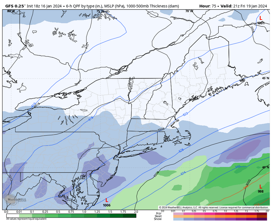
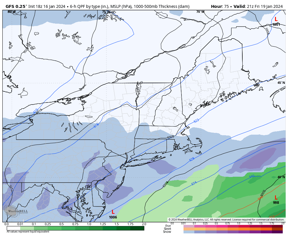
GFS has SS energy waayyyy out in front of NS meet n greet, which is muckin up a better event IMO. RGEM has enough interaction to enhance qpf round here, and snow maps above show it. Not saying its right, but its the one to hug for now.
-
1
-
-
2 minutes ago, MillvilleWx said:
Glad to see everyone cashed in on the storm. Looks like 3-5” was very common. Let’s smack another on Friday!
I posted a few snippets about nooners and what is showing. Whatchu thinkin for the Friday deal?
Looks like we get some phasing of NS, but not really a big trifecta of sorts. Trough rather progressive so once again, while a good event, upside to me would be coastal slowing down and hangin back a bit, but not really sure how much further amplification there could be. RGEM was nicest to look at, ICON wasnt too shabby, and GFS a little strung out but workable. I'd think a 3-6 kinda deal isnt far fetched??
-
1
-
-
Just now, AccuChris said:
Up to 3.5” now in Lebanon with steady snow still falling
back to pixie dust here, but its coming down pretty well. Def windage increase as well.
Central PA Winter 23/24
in Upstate New York/Pennsylvania
Posted
Nice to see overnighters holdin on to another event for Friday. Getting close enough that the carpet might get tugged on, but it shouldnt get ripped out from under us. 2-4 on top of earlier week event makes for an awesome week, as no matter the end result....its snow on snow.
Happy Pre Snowy Friday to all.