

pasnownut
-
Posts
9,002 -
Joined
-
Last visited
Content Type
Profiles
Blogs
Forums
American Weather
Media Demo
Store
Gallery
Posts posted by pasnownut
-
-
9 minutes ago, MAG5035 said:
I just think it’s boiling down to the antecedent airmass in place and the storm evolution itself. We’re set up fairly decently for this event as far as features in place but the antecedent cold isn’t very impressive. The high is there but it doesn’t seem like it’s being progged to be very efficient with drawing the cold air associated with the high into the system much at all until the storm gets going more off the coast under New England when it’s past us.
This is where I think the earlier miller B solutions would have been better for us. A more developed primary trying to come up and transferring under us would have established the northeasterly flow to draw more cold air from the high. This has become pretty much a straight miller A that’s winding up later and making the event here pretty much an quicker hitting 8-10hr one for the best precip… and it’s not pulling in more cold during the event in time to push the rain/snow line in our region. Surface low track is going to be key and a little bit of difference is going to go a long way either direction in that LSV southern tier.
Great read as always. Good luck out there, you lucky bugger.
-
34 minutes ago, Mount Joy Snowman said:
Been studying the overnight runs and I think the writing is on the wall for us down here in the SE part of the LSV. This was mine and Training's and some other's fear all along. Just seen this movie too many times before with the strong coastal Low warming the mid-levels with ocean air when it gets ramped up. I think most of the Mesos will start to show copious mixing issues over the next 24-48 hours. Reducing our forecast for most of Lancaster to 1-3", and 2-4" for anyone SE of the Gettysburg-Harrisburg-Lebanon-Reading line. Although I do think this is one of those scenarios where Elizabethtown could do a good bit better than Lancaster City, with the most prolonged rain/snow/sleet battle setting up somewhere around NW Lancaster County. Also, marginal surface temps will make for less efficient accumulation (certainly less than 10:1), particularly when rates lighten up. Overall, a bit of a disappointment considering where things stood for most of the week but I'll still be happy to see snow and cheer on those in the money. As always, put me in Laporte ha.
In truth, I'm not sure how many of us LSV/Lanco folk, were ever over expecting to be in the big stuff down here. Pattern never really suggested it, and thats why I've stated things about the column is going to be marginal for us, and dynamic cooling in higher qpf was needed for us. For the norther and westers, they should be fine. Nothing we've seen has been supportive of big snow here. Factor in knowing normal biases and climo for your backyard, and it should temeper any big expectations for US. Norther/westers....congrats in advance.
For me anyway, my efforts have been to see a storm in for CTP during a time that pattern really hasnt looked great and was written off by some.
if I get into the better stuff, then all the better, but my 3-6 for lanco is where my flag is placed, and I'll keep it there until shot down or we take the hill. Everyone has seen our area ranging from 1-8" model dependent, and I'm not gonna say well 25% of this and that worked, as I'm not that good and will not search for ways to say I was right.
No matter the end result, the forum is staring down a decent winter event.
Thats a win no matter how you slice it.
-
 1
1
-
-
39 minutes ago, mitchnick said:
Well new Cansips has a great January. I just wish MR modeling would cooperate because they're showing nothing but lake cutters.
.thumb.png.9c136427c6912b9b17d3f304b26a511a.png)
GEFS and GEPS have been hinting at LR basin look, and tellies are supportive of it.
Hoping for ENS guidance to increase that look as it would be a nice pattern to get stuck in for a while.
Frozen bowlin balls from the west w/ a 2 finger palm grip for extra left spin to hit us king pins here in the east.
and yes....thats how I bowl.
-
1 hour ago, mitchnick said:
If we don't stop the bleeding today, preferably reverse direction, I'm toast.
I recall discussions at easternwx years ago that the reason for slow north drifts was because modeling incorrectly forecasted the strength of blocking/high pressure to our N/NE. If that was, in fact, the problem, they haven't fixed it yet.
Never heard what the problem was attributed to...but I've never stopped factoring that into my expectations. I'm stickin w/ my 3-6 gun as nothing overnight scared me off. Actually 6z euro that anthony posted was rather encouraging, as euro has been running warm. Regardless, I'm on the razors edge as usual, and have kept my expectations in check for the LSV, but as i suggested yesterday, Altoona (MAG) to Poconos are looking pretty sweet for a nice event.
-
1 hour ago, mitchnick said:
Honestly, I have not watched local tv for weather, when I lived in MD or here, since PD2 in 2/03.
Since Calhoun and 27’s guy left I stopped watching as well. Don’t miss local weather stations.
-
6 minutes ago, MAG5035 said:
To further on what Anthonyweather shared a couple posts above from DT about the miller A vs miller B scenario, the Miller B scenario in this case would have been best for a longer duration system and more of a broad shield of precip across PA. The A solution that most guidance has settled upon shortens the duration and tightens the band of best QPF up since the system itself isn’t progged to be overly strong anymore. So the folks that see some of the best amounts are probably gonna be living dangerously in terms of the proximity to that changeover line.
Said it the other day…Gotta smell the rain for the best snows.
NAM looked way too paltry based on a ton of other guidance, but it has been locked once or twice before. signals been strong for too long.
The words “toss it” come to mind (even if it knows something the rest don’t). That fits my feelings better for now.
-
well at least on the HH NAM, i'm safe from mixing.

-
9 minutes ago, Voyager said:
Maybe you should stay out of our thread. Most of us get along quite well and don't mind the off topic (and sometimes off color) banter. We're all friends here, and every one of the regular, long term posters are well respected.
Guessing someone got offended and called the popo in. Sure hope Atomix is not out as there are others that have tried harder to muck up our crew...and they are left unchecked.
and btw, I'm dead to a couple in here.

Enjoy your snow this weekend. You know you will a weee bit.
-
2
-
-
1 minute ago, paweather said:
CTP on board:
.SHORT TERM /THURSDAY NIGHT THROUGH SATURDAY NIGHT/...
Arrival of 1030mb high pressure ends snow shower activity
Thursday evening with clearing skies. Low temps trend about 10F
lower night over night with minTs in the mid teens to low 20s
Friday morning. Fair wx to end the week with sunshine giving way
to increasing clouds Friday night ahead of weekend storm
system.

The weekend coastal storm has its origins in the Four Corners
region of the southwest US Thursday afternoon, with another area
of low pressure forming along the Mississippi Gulf Coast by
later Friday. The broad, double barrel low will track to near
the Delmarva region by 00z Sunday, when the coastal low becomes
dominant.

The potential still exists for a high end advisory to low end
warning level snow event. Snow onset timing looks like Saturday
morning to early afternoon with precip spreading from south to
north across CPA. Heaviest snowfall would most likely be in the
afternoon/evening into the first part of Saturday night with,
with lighter snow tapering off between 12-18Z Sunday. The
greatest uncertainty with rain/snow ptype is from I81/78 to the
I95 corridor.

&&

.LONG TERM /MONDAY THROUGH WEDNESDAY/...
The transition to a very active flow pattern over North America
is forecast to continue during the long term period. Monday
will be a quiet day, after what is forecast to be a considerable
coastal storm over the weekend likely bringing the first
significant snow for Central PA in some time, another wintry system
looks promising for mid week. At the current time, the mid week
storm system is forecast to be stronger and with a track of the
primary sfc low going west of PA. This presents a snow to mix
to rain scenario for the region.

Another key impact with this storm is the potential for
strong winds with MSLP anomalies (sub 990mb) reaching 3-4SD
below the mean.

Much too early for details, but much excitement for sure for
snow lovers as we plunge into the New Year.
thats about as good as one could ask for....considering the source and normal bias.
-
1
-
-
anyone feeling a good ol NAM'ing for HH?
Hope that offends noone.....
-
@Atomixwxi'm just messin w/ ya dude.
You add alot of "color" to the group.
")
-
5 minutes ago, Porsche said:
Very true, we are sometimes on the good side of the edge and other times not so much. Either way like you said, it's nice to be tracking something. Hopefully we can all enjoy some shoveling this weekend.
Yeah, to the other side, we've had some years that we've been in the goods whily they might have pushed Atomix over the edge a tad....
-
5 minutes ago, mitchnick said:
Same movie as with 6z. Operational goes off on one of its wild tangents and ensembles bring us back to reality, for better or for worse. In this case, as at 6z, for better.
Agreed. Not sure why my TT is seemingly slower than y'alls/ younz? Happy for you rich retired guys that get the premium stuff.

-
Just now, Porsche said:
Living on the edge, like to see this shift south slowly over the next 48 hours.
Its what we do down here. IMO to cry about what we often see here is silly and we should know better than that (or move)..especially based on pattern and lack of deep cold air. Just happy to see "us" in the game...even if some of us are not the stars of the show. Any snow is welcome snow in MBY. I'll be at cabin, so I'll likely be on the northern periphery anyways. NBD.
Hoping you get your souther tick before the dreaded norther one comes a callin. At least we are slowly runnin outta time for big changes.
-
2 minutes ago, anthonyweather said:
Do we do separate threads here for storms or keep it within winter talk?
.We NEVER separate threads here. You'll get everything you wanted (and didnt) all in one big lump....and like it.
-
4 minutes ago, Superstorm said:
EPS slightly higher from 06Z and 00z.
pleasant surprise eh....
-
11 minutes ago, KPITSnow said:
storm mode only counts if the mid Atlantic is involved
or when they say so.
-
22 minutes ago, mitchnick said:
Lots of mix or even some rain in eastern areas there too. Inland different story as usual.
Based on track its no surprise to some of us that are used to this. MAG to Poconos has always been my early goalposts w/ about 75-100 miles on either side "getting the goods". I may be wrong but Im not afraid to share my thoughts. Me thinks 8-10 is big winners and I'm ok w/ my 3-6" until further notice. lol
-
10 minutes ago, Voyager said:
I can relate to the snow hole as models always predicted a lower total "horseshoe" around Tamaqua no matter which way the storm was coming.
"Tamaqua split" is what you called it.
-
No matter how the cards fall in the next couple weeks, it's great to see chances lining up in the short/medium terms.
ENS guidance still wants to dump the trough in the west until about 8-10 days when a more basin wide look seems to show. Hoping we can score a couple before that happens. Further out, with AO/NAO still neg and PNA showing a move twds neutral, that basin wide look might have merit and could be fun for us.
-
11 minutes ago, mitchnick said:
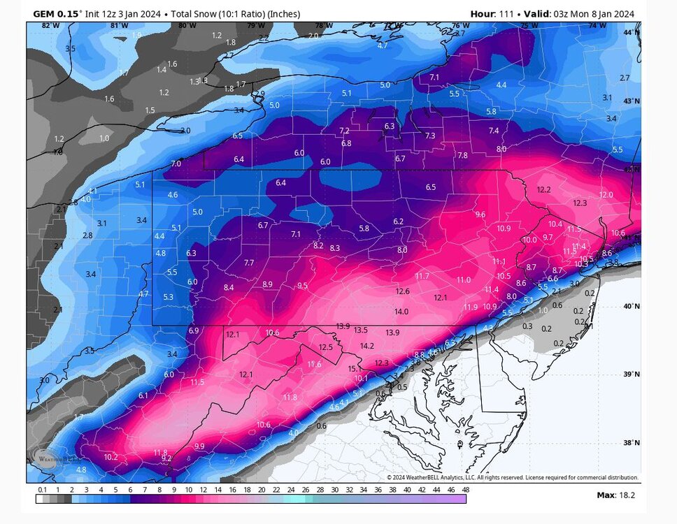
Ukie held
.thumb.png.a47c236c0e3e8d63c286106690f43ba4.png)
and like so many times in the past, that blue dot between the 4.9 is right over my house. Some things never change....hehe (not for a second do I really care or worry about it) - just funny how models consistently do that for Lanco. It's like they troll me.
-
 1
1
-
 1
1
-
-
After general review of nooners, only worry I've got down here in LSV'ville is that 540's ticked north, and at 72hr out, still some subtle jogs left to decide winners and losers....Hoping that trend stops, but as many of us know, that is something that happens all too often.
That said, there should be a decent amount of winners in our group (norther/westers).
-
2
-
-
5 minutes ago, Wxdavis5784 said:
12 Z Canadian
Definitely the "hug worthy model" .
Nice to see nooners upping the % of a widespread event for many snow starved geeses (cause y'all LOVE geeses).
-
2
-
-
8 minutes ago, Atomixwx said:
I thought that even with those rules established, we still considered der iKon such a laughable model that it wasn't even given the benefit of "look at what this shows," except to point and laugh when it fails miserably.
Now watch this be der iKon's NAM moment.
Sent from my motorola edge 5G UW (2021) using Tapatalk
Iget ya. For me/others its all about consensus building and creating goalposts. Happy to see its on board for something. Thats all.
.png.799d331a38648eb129fb9fa01124ecae.png)
.png.78baee4521d53e974e6ebaccc8db178d.png)

Central PA Winter 23/24
in Upstate New York/Pennsylvania
Posted
Looks like its coming around. Right or wrong, its a CTP special and I'd think most here would take it and run (even if we take totals and multiply by .6)