

pasnownut
-
Posts
9,002 -
Joined
-
Last visited
Content Type
Profiles
Blogs
Forums
American Weather
Media Demo
Store
Gallery
Posts posted by pasnownut
-
-
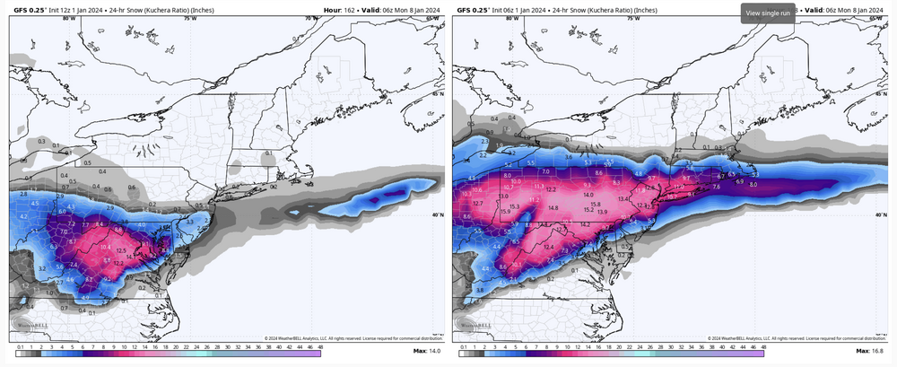
11 minutes ago, GrandmasterB said:
Quite a bit more snow than the 6Z
6z seemed to be an outlier (right or wrong)
-
 2
2
-
-
11 minutes ago, Mount Joy Snowman said:
GFS is in a good spot but is such a swift mover it dampens totals a bit....
Edit: totals go up a wee bit more as snow showers linger through Sunday
pattern always suggested this would be a quickish hitter with no deep troughing to help slow things down. I'll take my progressive 3-6 and be giddy at that.
Beggars........
-
1
-
-
34 minutes ago, anthonyweather said:

Hr 84 of RGEM would lead you to believe central and eastern pa get hit pretty good. CMC should be good here shortly
.RGEM thermals a tick better for LSV at 78. All i can see for now.
-
34 minutes ago, Atomixwx said:
So we take der iKon seriously now? Lol
Sent from my motorola edge 5G UW (2021) using Tapatalk
You've been doing this long enough. Weenie rule #1 is hug ANY model that give you snow, then cherrypick for your wish list.
-
2
-
-
51 minutes ago, Itstrainingtime said:
I really, really do hope he is wrong...but until he is wrong, he isn't. I've seen models/forecasts for a lot more snow than this disappear with much less time remaining before onset.
I'm not negative, but I am jaded. Many, many years of last second failures has taught me to assume nothing when it comes to snow. Until it's on the ground, that is.
I get your being jaded, as we share same weather and like you, i've been at this hobby for over 35 years.
Point I'm making is that while we still may fail, many here can see signs for optimism and didnt need to wait for someone to say so.
Doesnt mean we all win, (and we all know that losing is always the safer bet wrt our precious snow), but unless the bottom drops out, we are in short term, and staring down our first appreciable event and cautious optimism is warranted.
The reasonings why have been shared by some of us for some time now...and are largely ignored/dismissed by others.
On a disco forum, that's the rub for me anyway, and while almost all of us have no formal titles or pins to put on our chest....we still have plenty to offer towards good weather disco and offer info to support our claims...right or wrong. Isn't that what a disco forum is for? While he and others are pretty/really damn good, they are capable of being off....just like the best of the best here and everywhere. Part of the fun for some/many is trying to nail down an event long before it happens, and frankly for me, what I enjoy most. The event is almost anti climactic, as i need to start searching for the next one to hunt and sometimes they are few and far between (2016 and last year come to mind).
Here's to some great nooners.
-
1 hour ago, Blizzard of 93 said:
When the low gets towards the DelMarVa, I think most of CTP will be good for snow.
I just want a juiced system that doesn’t cut & we should be good for snow.
Agreed, its nice to have a system stay under us...no matter how it unfolds. While I see all of the nice maps, like some/many, I realize the typical climo says LSV is often on the edge.
Me thinks that IF we can get things in E Central Ohio to clean up a tad, that may help to protect our precious thermals down here. See below and you'll see what i'm getting at. CMC also has it to some degree. GFS notsomuch. Mind you we cant wish things away, but as not all models have it, its what I'm focusing on for the next few runs.

-
52 minutes ago, Blizzard of 93 said:
When the low gets towards the DelMarVa, I think most of CTP will be good for snow.
I just want a juiced system that doesn’t cut & we should be good for snow.
looking over Euro 850's there is a warm punch on the MD line on 6z where it was 50-75 miles further south on 0z. Unfortunately it's not outside of the rhealm of possibilities. Hoping consensus says otherwise with nooners.
-
55 minutes ago, mahantango#1 said:
Time to start panicking?
Some never stop....

-
1
-
-
1 hour ago, mahantango#1 said:
From your fiends ss:
 Favorites · 30m ·
TODAY IS WEDNESDAY 1-3-2024FORECAST ISSUED AT: 6:45 AMSNOW AMOUNTS OF 10-15” ARE BEGINNING TO LOOK PROMISING
Favorites · 30m ·
TODAY IS WEDNESDAY 1-3-2024FORECAST ISSUED AT: 6:45 AMSNOW AMOUNTS OF 10-15” ARE BEGINNING TO LOOK PROMISINGlol I cant believe anyone still follows them after the debacle they had some time ago. Guess memory is short term for some, or if you keep throwin enough crap at the wall, some still sticks.
you are settin pretty for this one pal. Try to enjoy it, and we look forward to some awesome pics.
-
1
-
-
1 hour ago, Mount Joy Snowman said:
Low of 26 here. Lancaster continues to appear to be in a great spot for the upcoming storm, almost too good ha. I continue to like the idea of an area-wide 4-8”. Things are getting clearer. By 12z tomorrow we should be full-go.
After parsing over overnighters, my loins are starting to feel something as well.....
Just remember, that guy from MU said no snow till mid late month or early Feb, so none of this really counts, so is all bonus stat padder kinda stuff. Hehe.
-
1
-
-
11 minutes ago, mitchnick said:
Welp, day 10 Euro has some big potential.
good. look forward to seeing it in a few minutes.
-
Just now, mitchnick said:
Just out and a touch better than 6z.
.thumb.png.6e0fd2f8fda999473418208f3bf6bb44.png)
thats good to see. Euro only out to 90 for me, so I'm relying on all of the pbp's .
-
1
-
-
16 minutes ago, mitchnick said:
Fast movement also reduces the amount of warm air off the ocean can get involved, so there's that.
Good point. Axis is NE enough to thwart cookin us too much.
Were trough axis deeper, then we'd have more to worry about (other than Euro just shartin da bed a bit).
-
18 minutes ago, Wxdavis5784 said:
0z Euro Run
12 Z hot
off the press:messFYP
-
 1
1
-
-
One other note is that at 114 GFS is coldest a 500's while GEPS/GEFS are warmer.
Gotta love the model drama.
-
16 minutes ago, MAG5035 said:
Weatherbell really didn’t send a changeover across the Mason-Dixon Line. I know the algorithm gets a rap for being snowy or whatever but that particular map is a 6hr frame and if you use a 3hr frame bulk of QPF is thru York/Lancaster by 111hr. Thermals at 850/925mb/surface are still fine at that point. At the 114 hr frame the 850mb 0 line is shaped pretty much like the changeover line on that TT map but the 850 temps are still within tenths of a degree of zero in that little rain area that intrudes into PA as are 925 and surface. So if there’s any heavier precip left between that 111-114hr frame there it’s probably going to be snow… albeit likely at reduced ratios.
Great post. Like you , I looked at timestamps for periods in question and noticed much the same. Skew T's had me at 33 max and much qpf was already laid down, and column was close enough to not yet worry (but 700's to surface were scarily close). Even if I did end as drizzle/snizzle, I'd be happy to see an appreciable event.
Mind you not much dissecting will matter at 4+ days out, and we should just be looking for consistency/trends to get hammered out right now, but it sure is fun to be seeing winter on the maps though.
-
21 minutes ago, GrandmasterB said:
Too close for comfort down here with 4 days left to go. For MBY I’d like to see the stronger primary/less confluence trend reverse tonight or tomorrow or we’re in trouble.
Yep, but this is par for the normal course of play down here. Only thing I'd add to your thoughts is that while stronger primary can kill thermals, if close enough temp wise qpf can overcome marginal temps. Not saying thats the case but something to ponder.
-
1
-
-
6 minutes ago, mitchnick said:
Icon a big hit for us again.
nooner extrapolation of Z German model
1.slp slightly weaker - likely not as good for CTP qpf wise,
2. a bit slower
3. a tad colder at surface (see below) but later panels really close for LSV and show a touch warmer for Lanco ish
Overall, still in the game, but nerves of steel need to come outta the closet for some of us SE'rs. The old saying you gotta smell the rain for the best snows comes to mind. I'd be smellin it. ESE winds in next panels always scare down here. Its just one run w/ many many more left. Nice to see all the same.
6z

12z

-
56 minutes ago, Blizzard of 93 said:
If you want to treat yourself, go take a look at the 6z GFS total snow map through day 16….
As we've been suggesting #1 sorta sets the table for #2 and yeah #2 looks a touch better. Might not lose all of our precious snowpack. If we do, #3 looks to freshen it up (verbatim).
parsing over GFS progression, it has come notably further S w/ #2, IMO the -NAO should help to keep this from cutting, so I'm gonna believe what the 6z is showing for that reason.
-
2
-
-
14 minutes ago, Blizzard of 93 said:
The second storm for the 9th or 10th always has looked for days like a cutter on the ensembles & now we are barely in Op range for the Euro & Canadian.
Our best hope for the second storm is a good front ender if the High in Quebec is strong & holds a bit.
The 12z GFS says no this run, but the Canadian says we have a chance on the front end with a stronger High up north.


I think we need to get closer to event 1 before getting too worried abt storm 2 (not that you are worried..hehe).
Gonna be lots of wiggle n wobbles for the next few days for #2. verbatim 1038hp way up in land of kanooks is stoudt, but ridging out ahead is kiss of death. Hoping that supresses as time moves on.
-
2
-
-
31 minutes ago, Itstrainingtime said:
You may be right.
But I still would rather be in our position now then holding on to the SE edge of snowfall.
Where were we 5 days out in 1983? 1996? 2009? 2010? 2016? We were on the outside looking in. All 5 of those came north and clocked us. Sure, no guarantee that will happen this time but I'm actually more optimistic now than I've been in years.
just getting caught up and saw this.
agree 100%
-
1
-
-
Happy New Year to all.
Hoping for health and happiness to all in 2024.
-
3
-
-
30 minutes ago, MAG5035 said:
Well the run to run consistency was fun while it lasted lol
I'm fine w/ slp placement at 6 days out...and likely not far enough south for much comfort down here. Hunch says it comes north like they usually do. Once the 500's clean up a bit (12z showing 2 areas closed off) me thinks thats not likely and prob what gave the 12z southern slider look.
-
3 minutes ago, anotherman said:
Embarrassing. I’m done with this coaching staff. Just complete ineptness across the board.I was resistant to this mindset, but now am starting to think more of it....
Just dont seem hungry, and its ok to stick w/ a plan when working, but when its not....
.png.2152a42cf7d021fb8febe3d03804d50e.png)


Central PA Winter 23/24
in Upstate New York/Pennsylvania
Posted
and for marginal areas, intensity is the way to the snowy white promise land.
Words that live in infamy....we can overcome.....