

pasnownut
-
Posts
9,519 -
Joined
-
Last visited
Content Type
Profiles
Blogs
Forums
American Weather
Media Demo
Store
Gallery
Posts posted by pasnownut
-
-
102 also transfers in N Va. good spot for us, as dry slot would be muted up here.
-
 1
1
-
-
102 has snow up to NY border.
Crowd pleaser fo sho
-
Trend continues at 96.
-
SLP at 90 a smidge N of 6z
qpf field similar
thermals a tad N (which should allow a better adjustment N in next couple panels. I80 and S may approve
-
Just now, paweather said:
84 looks primed and loaded.
yep. Looking a touch N of 6z. Money panels incoming
-
1
-
-
at 72, nooner GFS is a tick N of 6z wrt thermal boundaries and SLP
good start, how will it finish....
-
1
-
-
2 minutes ago, Itstrainingtime said:
I'm hugging it until we find a model that gives us more.
absolutely. Regardless of how these next couple weeks work out, legit tracking has commenced and is most welcomed by many. Nice to see a couple of chances looming.
-
24 minutes ago, Superstorm said:
ICON not too shabby....

I'd think many/most would take the 12z evolution in a heartbeat. I know I would. Nice to see most bigguns coming around to more norther options. Not sure I'd call it a consensus yet, but its starting to look like one is forming, and the souther whiff appears a bit less likely.
-
1
-
-
19 minutes ago, paweather said:
ICON is a good run.
But is it a good model......???
Well for today it sure is...
")
-
 1
1
-
-
48 minutes ago, Blizzard of 93 said:
12z Euro with a similar idea as the Canadian.
Advisory snow this run to the LSV & Warning snow just over the MD line.Only minor adjustment needed to get southern PA into the better goods.
qpf ticked south tho. You know trends are what we need to watch for now....not perty (or not so) snow maps. Just one run, and CMC came north so I say no blood.
-
6 minutes ago, Itstrainingtime said:
Confluence can weaken as we approach events. That's not a weenie statement. It has both helped and hurt us in the past. This could go further south or come back north. Pretty sure it won't go down exactly as depicted now. Lots of time to go.
Sure can. IMO biggest takeaway is we are getting into a new pattern, and one we've not seen in a while. Might have to dust the books off as to how things can and do evolve w/ setups like this. We've grown so accustomed to shoehornin our way into snows, antecedent cold blah blah blah. Now we've got cold where we want it and just need to see where the vort pops and start looking at 500/700 maps to see where this puppy goes.
-
2
-
-
2 hours ago, Superstorm said:
Definitely like what I see from the models.
.Yeah not a bad set of moves. As cold is often over modelled, it wouldnt surprise if we see a further adjustment north......
or is that the weenie in me coming out?
Happy New Years to all.
-
3
-
-
37 minutes ago, Voyager said:
I'm not sure I'm buying what the GFS is selling. This may stay south, but I'm not sure it'll be that far south.
cold press is legit and once established, you need to look at trough axis w/ each vort. Suppressed is surely an option, but when 3 op runs give 3 notably different solutions as to where the letter L is on said run, that means alot, and we just need time to see where the boundary sets up and go from there. Fortunately there are notable diff's from each model, so that tells us this is far from decided.
Happy to see the reshuffle now being reshuffled to a funnr pattern.
Happy and healthy New Years to all.
-
5
-
-
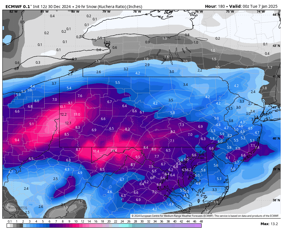
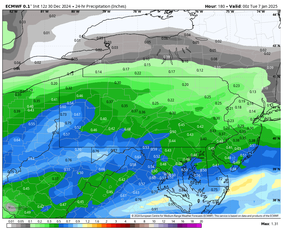
2 hours ago, MAG5035 said:
I’ll quote it, with 24 hour precip/snowfall
24hr Kuchera
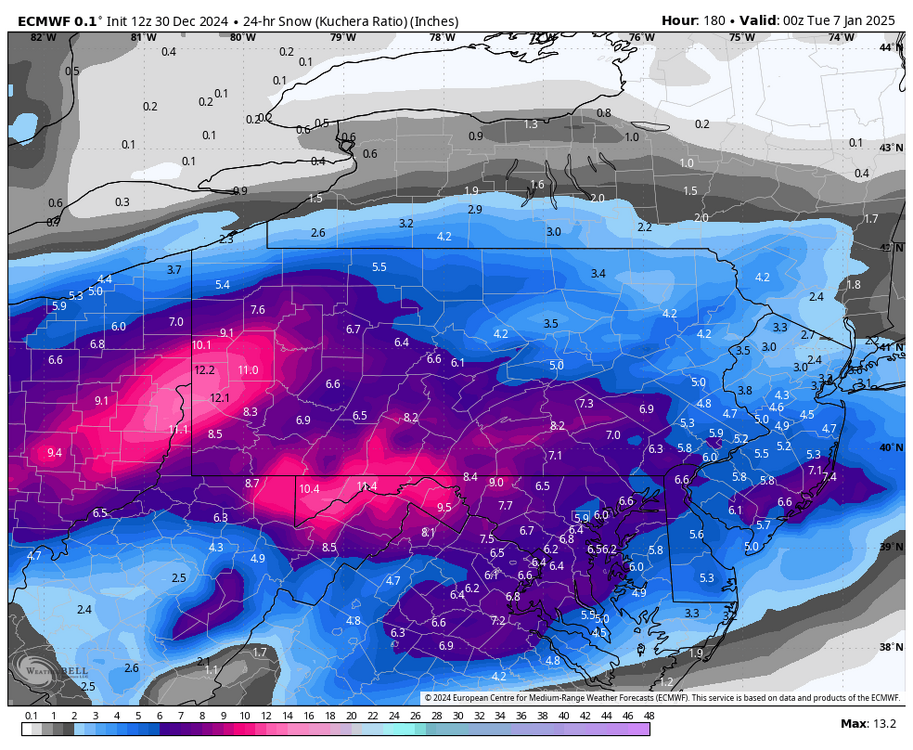
24hr total QPF:

I’m not gonna go too crazy with mathing all the locations but MDT’s 8.2” at 0.5” is about a 16:1 ratio… which is somewhat better than January climo. The 12z Euro had a very cold column with this event, with the -8ºC 850 isotherm never getting above MDT and surface temps in the low to mid 20s area wide. Definitely cold enough for better than climo ratios. Just strictly interpreting what the model is outputting, I’m okay with those higher snowfall numbers.
Whether thats the actual solution is obviously debatable at this range. It seems that guidance wants to bring more of this energy out front to make the main system in the 1/5 to 1/6 timeframe. We don’t have the 500mb alignment the whole way in place yet (western ridge asis off the Pac coast).. a stronger system that phases more energy in would likely cut. The GFS actually does cut the low but it’s weakening into what will be a decent antecedent cold airmass so result would probably be a majority frozen event for most here but mixing would be on the table. The Euro managed to get the low just underneath PA to a coastal transfer. If this is going to be the main system to get us here in C-PA, that’s probably the ideal solution.
Euro has been a bit inconsistent, big difference between it and the GFS at 12z. Very little blocking in the NAO realm and also trying to hang troughing back into SW (Euro bias)
12z GFS v Euro

Euro ensembles are more in line with GFS/GEFS. Still weaker in the NAO realm like the Euro op but big difference in not really supporting the Euro op’s trough digging in the SW
12z GEFS v Euro EPS

Pretty far out in range yet, but I’m leaning cold given the general consensus right now. Models have been targeting that 1/10 to 1/11 timeframe for a major arctic shot more often than not so far.
Great stuff as always Mag. Thanks for sharing. Looking forward to keeping an eye on this period.
-
4 hours ago, mitchnick said:
Nice runs on the 0z Euro and 6z Gfs.
yeah looks like all systems go and that 2025 may get us off to a good start. Op runs still doing their bouncin around a bit, but should lock in over next couple days and pattern stabilizes...me thinks. Low amp 8/1/2 while a muted signal, sure doesnt hurt with other tellies looking pretty perty.
-
1
-
-
Great weekend at cabin. Arrived Friday to 6” of snow to plow. Low key chill weekend. Left today at 840 am with 4” still otg and 37 deg. Once to wspt we hit the 40’s.
saw about 2 min of sun here at home but it’s warm.
Don’t worry blizz, hoping you won’t be alone on the limb soon enough. Looking forward to seeing how this evolves vs how modeled. Looks perty so far.-
7
-
-
1 hour ago, Voyager said:
I'm so glad it remained overcast today. Hope tomorrow is dark and overcast as well.
For some reason, I prefer cloudy on Christmas Day.
Amended for my rendition of perfect Christmas weather.
")
-
1
-
-
15 minutes ago, Blizzard of 93 said:
This guy is not an internet hype artist. I like when he is optimistic…

Sounds good by us...
while MJO influence may be muted, its proven to be stoudt when it show bad, so now we just need the goodr look as it propogates thru 7 and into 8 to hold. NAO/AO looking great on 2 week progs. PNA workable. I'm actually ok w/ no pig ridge out west, as if and when? it rolls over, like it often does, conus floods w/ pac and not polar pac origin air. As shown above, I'd pull many chips outta pocket and push em forward. Hold my ass baby.
-
1
-
-
44 minutes ago, Coop_Mason said:
I had a trace. 2025 gonna be rockin!
Starting to get a better feeling about first 1/2 of Jan. after that....dunno, but lets ride this train as long as we can (assuming it doesnt derail before it gets here...:)).
-
1
-
-
1 hour ago, Porsche said:
moderate snow here in New Holland, roads are covered and looks absolutely gorgeous on Christmas Eve. Merry Christmas to you all!!
up at 3:15 to take daughter to philly intl for her flight back to Colorado. Snow started to fall on way home around downingtown. Bittersweet as she loves snow like I do, so a nice (but sad) ride. At least we got to see her for a couple days (although rather sick).
It was and is gorgeous to see on Christmas Eve.
Wishing all a very Merry Christmas and safe travels.
-
8
-
-
27 minutes ago, mitchnick said:
Good news is the the Euro operational/Eps/Geps all agree on a continued decent look.
Ultimately, Gefs ending is not so bad, but delays in decent storms or patterns rarely work out well.
tellies are looking nice as we enter the new year.
IF the look holds, i'd think we'd be trackin stuff a week from now. Biggest help is that the MJO is looking to go solidly into 8 and with NAO/AO and PNA looking pretty good, just may need a little patience....grasshoppers.
-
 1
1
-
-
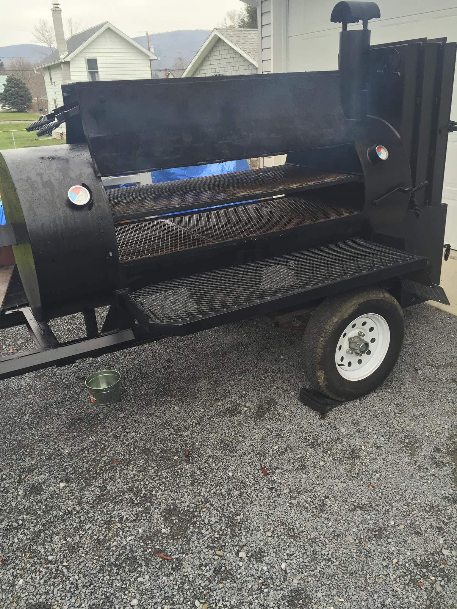
4 hours ago, pawatch said:
2 degrees this morning.
Nut I have a wood burner.
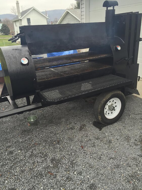
That'll do....
VERY nice stick burner. Hope the smoke was a good one.
-
1
-
-
9 minutes ago, pawatch said:
10 degrees this morning.
Tomorrow morning I have a big brisket smoke. Not looking forward to the cold.
No real surprises or upsets yesterday.
do you have a thermal blanket for your smoker? I've got a Green Mtn pellet smoker that has the blanket. It's a big help in temp control and pellet usage in the cold months.
check it out. https://www.bestproductguider.com/best-thermal-blanket-for-pellet-grill/
I've tried with and without, and yeah, over the long haul, worth the coins IMO. Mind you mine came w/ purchase off FB market, but I'd spend it knowing how it helps.
Enjoy smoking the brisket. at least beers wont get warm :).
-
8 hours ago, Mount Joy Snowman said:
I’m somehow still awake at a family holiday gathering in Northumberland. Let’s just say it’s been a long day ha. Big bounce back by the B10 today. Also solid snowpack up here. They’ll have a white Xmas for sure. I love everything, mainly penn state and snowpacks, but also everything. My uncle keeps feeding me Labatts, so there’s that.
A great day for you. Enjoy!
-
 1
1
-


Central PA Winter 2024/2025
in Upstate New York/Pennsylvania
Posted
of course, but now you have the GFS sayin.....
hold my beer