

mahk_webstah
-
Posts
11,845 -
Joined
-
Last visited
About mahk_webstah

Recent Profile Visitors
13,081 profile views


-
 That line was talking a big game. All show and no grow.
 -
How’d it turn out?
-
Bryan, you must have more than 1.2 inches. Look at this. I mean that’s more than 3 inches on top of the birdbath already. 79726418536__E72723D6-6D1E-43C6-8719-887BABD3CDC7.MOV
-
Not enjoying this 79725774645__97044C0A-00DE-458F-B690-F596D6828E3A.MOV
-
Glad we’ve been getting good rain recently. Time to warm the soil.
-
Happy to say no snow here, though it probably is snowing at Brian’s
-
Don’t feed the beasts
-
Ughhhh thanks
-
I’m so tuned out. Really? A lot?
-
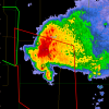
Pretty interesting on the ECAIFS for next Saturday through Monday
-
2-3” here and getting a very heavy snow shower now with perfect growth
-
3 coastals on the euro ai thru 3/21
-
My husband said it was more than he expected, but he refuses to measure. I’m guessing 5 inches based on looking at the cameras.
-
No snow condoms for you.
-
Wpc kinda hinting at that on its winter weather maps for Wednesday into Thursday. If the season holds to form that will trend colder. I’m guessing we’re not out of this until the MJO goes through phase 8 and we get rid of the polar vortex being near to us. Maybe we get an end to winter by the end of the third week of March? I hope so, there’s things to plant.


