

NavarreDon
-
Posts
2,819 -
Joined
-
Last visited
Content Type
Profiles
Blogs
Forums
American Weather
Media Demo
Store
Gallery
Posts posted by NavarreDon
-
-
First off Merry Christmas to all of you!
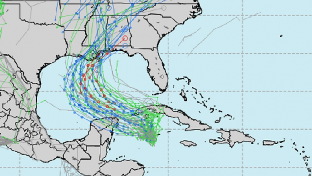
Spent some time this morning reminiscing by going back thru the old Christmas 2010 threads. Lot's of new faces but, lot's of us who rode that roller coaster. If you have time check those old threads & or post your memories of this classic! Mine were the gut wrenching model runs. The highs, lows, & highs. Waking up before my kids on Christmas morning to catch up the discussion threads, then seeing actual snow falling in Weaverville, NC, my all time favorite AFD by GSP that started with "Sometimes I think I should have been a farmer!", to finishing with over a foot of snow. What are some of your favorite memories?.......has it really been 10 years!!!
-
 3
3
-
-
Definitely the wrong time of the year to shave your head, if there is ever a right time!
Front is starting to show its power. Temps have crashed into the upper 40s in the middle of the day in the Western Panhandle, including the Pensacola, Fort Walton Beach, and Crestview areas.
‘Twas a brutal day up this way! Already in the 30’s with a stiff NW wind. High tomorrow just lower 40’s & then upper 20’s Saturday morning.
.-
1
-
-
Merry Christmas guys!!! Congrats to all who cashed!
.-
2
-
-
Got down to 30.4° near the coast this am! Forecast was for 34°. Had to start the wife's car to rid it of frost.
-
2
-
-
14 hours ago, turtlehurricane said:
Freeze watch in the westernmost part of the Panhandle... first freeze advisories of the year in Florida? I'm not 100% sure, but I think so.
...FREEZE WATCH REMAINS IN EFFECT FROM MONDAY EVENING THROUGH
TUESDAY MORNING...

* WHAT...Sub-freezing temperatures as low as 25 possible.

* WHERE...Portions of south central and southwest Alabama,
  northwest Florida and southeast Mississippi.

* WHEN...From Monday evening through Tuesday morning.

* IMPACTS...Frost and freeze conditions could kill crops, other
  sensitive vegetation and possibly damage unprotected outdoor
  plumbing.
Yes they are the first. Currently in the low 50's with a strong NW wind (Wind advisory all day). Temps won't budge all day!
-
1
-
-
13 hours ago, Prospero said:
For the first time this year, I am actually starting to get a gut feeling like we might get hit harder than we've been expecting here in Tampa Bay.
Not a lot of time to get ready, and no warnings up yet.
Hopefully I am wrong.
")
Welcome to Hurricane season 2020!
-
2
-
-
Just saw this, hope I’m in! 903 155KT
. -
52 minutes ago, Windspeed said:
Banding on the south side of evident mid-level cyclonic rotation. Still no certainty of a vortex down at the surface but with that strong convective band aligned west to east and curving into the MCS, I have seen far worse classified a Tropical Depression. Getting a little impatient. We do not have any recon flight plans yet.


Has the TD look for sure!
-
This may be one of the strangest disco's I've ever seen (MOB).....2020 I guess.
.NEAR TERM UPDATE /Now Through Friday/...Hurricane Zeta was
moving rapidly northeast at ~30 mph over the interior of southeast
MS/southwest AL. Along the path, Zeta has been responsible for
downing widespread trees which have taken out power lines and
have contributed to structural damage. Life threatening/dangerous
storm surge will continue over the coast. Zeta will continue to
accelerate northeast through the night and is progged to lift out
of the forecast area shortly after midnight. As the center of Zeta
lifts out and weakens, strong winds will begin to taper as well
as the tornado threat. Rain bands will also gradually move from
west to east. A vigorous southern stream mid-level trof ejects
eastward over the Lower MS River Valley Thursday and makes steady
eastward progress over the southeast US Thursday night. This
feature supports the passage of a strong cold front Thursday,
which brings drier and cooler air to the local area in its wake.

Coolest highs will be over the western zones with numbers in the
mid 60s. Mid 70s along I-65 and 77 to 82 east of I-65 southward to
the FL Panhandle. Overnight lows dip down into the mid to upper
40s north of the coast Thursday night.
-
 1
1
-
 1
1
-
-
Getting a decent blow in Navarre now, gusting to the mid 50’s.
. -
-
Lightning in the eyewall this late in the game....wow!!!

.-
1
-
-
-
-
Found this little gem while checking our weather.

.-
2
-
 1
1
-
-
Impressed with the HWRF on this one. It wasn’t perfect but it got the gist of it.
. -
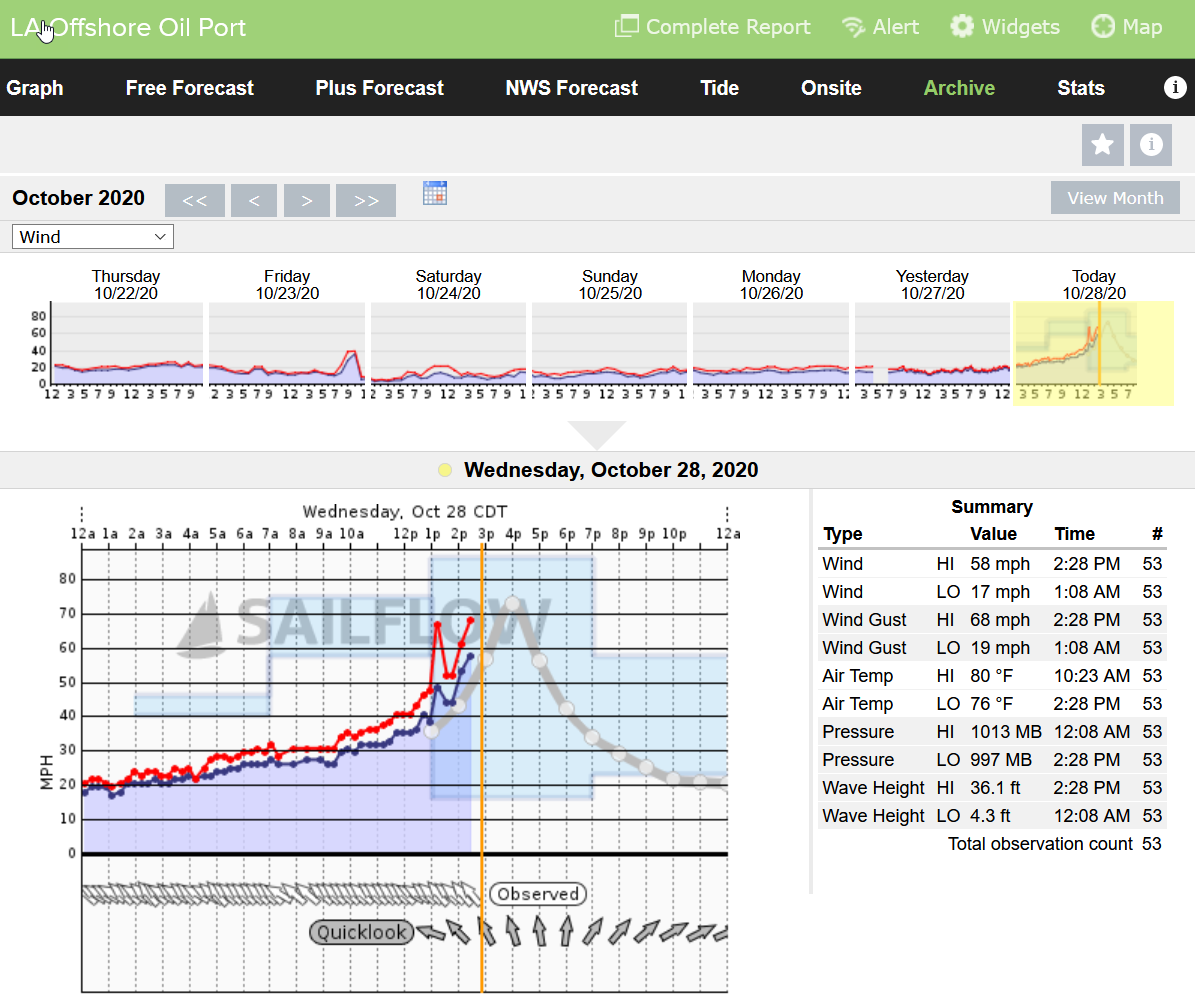
Looks like LA Offshore Oil Port just went offline. I think most in the area have dropped in last 30 minutes or so.
36.1 ft wave height. Whew, wonder how that will translate with any storm surge.
Look at this!!!
.-
2
-
-
-
Looks like these are flagged but it makes one wonder what they’ll find in the NE pass.

.
-
-
MOB has a decent write up about some of the inland affects below in last nights ST disco...
SHORT TERM /Wednesday night Through Thursday night/...Bands of
heavy rain and gusty winds will increase across the area on
Wednesday night as Zeta approaches the local area from the
southwest. At this time, landfall is forecast to occur in southeast
Louisiana sometime early Wednesday evening and then lift northeast
across southeast MS and into parts of southwest AL Wednesday
night. Tropical storm conditions (strong wind gusts and heavy
rain) will spread northeast across our forecast area Wednesday
evening into the early predawn morning hours Thursday. This system
will be interacting with a cold front and broad region of
associated diffluence aloft, so it is unlikely we see the typical
decay after landfall that we would see in storms earlier in the
season. In fact, model soundings continue to suggest upwards of 80
to 100 knots of flow in the eastern quadrant just off the surface
(925-850 mb layer) persisting well after surface winds have
weakened as Zeta moves inland over interior southeast Mississippi
even up into central Alabama. This will serve as a source of
momentum for heavy convective bands to transport to the surface.
Therefore, while locations along and west of I-65 will have the
greatest chance of seeing sustained tropical storm conditions
Wednesday night, can`t rule out frequent strong gusts to tropical
storm force farther east as well. As a result, a Tropical Storm
Watch has been issued for the entire local area. a weakening Zeta
accelerates quickly northeastward and by early Thursday morning
Zeta is expected to be over northeast AL and moving rapidly away
from the area with winds and rains gradually subsiding during the
day on Thursday.
.
-
2
-
-
-
Recon just arrived, let’s see what they find.
. -
Hello!
-
1
-


10 year anniversary of the Christmas 2010 snowstorm
in Southeastern States
Posted
Found some old GSP discos that just bring back the excitement!
.NEAR TERM /THROUGH TONIGHT/...
THE PAST FEW MODEL RUNS HAVE VEERED DRAMATICALLY BACK INTO THE HEAVY
SNOW CAMP FOR THE WESTERN CAROLINAS AND NE GA FOR TODAY AND TONIGHT.
A NRN STREAM STREAM SHORT WAVE IS DIGGING MORE THAN THE MODELS HAD
ORIGINALLY PREDICTED. THIS FEATURE CONTINUES TO STRENGTHEN AS
INDICATED BY THE INCREASING DARK BAND ON WATER VAPOR IMAGERY OVER
THE SRN PLAINS. THIS IS RESULTING IS DOWNSTREAM UPPER DIVERGENCE AND
QG FORCING. A BAND OF 600 MB FRONTOGENESIS EXTENDS ACROSS TN AND
INTO WRN NC. THIS BAND IS MOST CLOSELY ASSOCIATED WITH THE PCPN OVER
SRN TN. THE FRONTOGENESIS IS PROGGED TO STRENGTHEN THROUGH 18
UTC...WHICH MATCHES THE INCREASING PCPN TREND. THE LATEST GFS AND
ECMWF NOW HAVE 0.50 TO 0.75 INCHES OF LIQUID EQUIVALENT PCPN OVER
THE MTNS OF NC/SC/GA AND THE NC FOOTHILLS THROUGH 00 UTC TODAY. WITH
A SNOW RATIO OF 12:1...THIS WOULD YIELD OVER 8 INCHES OF SNOW IN
SPOTS. WE/VE BEEN PLAYING CATCHUP WITH THIS EVENT...AND THE 6 INCH
TOTALS I HAVE IN THE CENTRAL AND SRN NC MTNS TODAY WILL PROBABLY
NEED TO BE BUMPED UP ANOTHER COUPLE INCHES AT LEAST. THIS AMOUNT OF
SNOW IS LIKELY TO DOWN TREES...CAUSE POWER OUTAGES AND WILL MAKE
CHRISTMAS TRAVEL NEARLY IMPOSSIBLE OVER MUCH OF THE MTNS BY LATER IN
THE MORNING....WITH THE NC FOOTHILLS EXPERIENCING SIMILAR CONDITIONS
LATER IN THE DAY. IN SHORT...THIS IS GOING TO BE A SIGNIFICANT AND
DANGEROUS WINTER STORM FOR THE MTNS AND FOOTHILLS TODAY.
THEN THERE IS PART TWO. A POTENT SRN STREAM SHORT WAVE...WHICH IS
ONLY INDIRECTLY RESPONSIBLE FOR THE HEAVY SNOW TODAY...WILL BE
PICKED UP BY THE NRN STREAM WAVE. AS THE NRN STREAM WAVE IS SLOWER
AND DEEPER...IT LOOKS TO PHASE MORE WITH THE SRN STREAM ENERGY THAN
ORIGINALLY EXPECTED. AS STRONG DEEP LAYER Q-VECTOR CONVERGENCE
DEVELOPS OVER THE REGION TONIGHT...A PIVOTING BAND OF SNOW IS
EXPECTED TO CONTINUE OVER THE EASTERN PART OF THE FA. BOTH NAM AND
GFS CROSS SECTIONS SHOW A GOOD AREA OF NEGATIVE EPV CROSSING THE
FOOTHILLS AND PIEDMONT TOWARD 0600 UTC. AS THIS HAPPENS...A PERIOD
OF HEAVY SNOW IS EXPECTED ACROSS THE I-77 CORRIDOR AND INTO THE
CENTRAL AND SOUTHERN UPSTATE. FOR NOW I/M JUST GOING WITH 2 TO 4
INCHES OF SNOW FOR THESE AREAS...WHICH IS STILL ENOUGH TO WARRANT A
WINTER STORM WARNING UP THE I-85 AND I-77 CORRIDORS. HOWEVER...IF
THIS WESTWARD ADJUSTMENT AND PHASING CONTINUES...THEN HEAVIER SNOW
IS VERY POSSIBLE.