

NavarreDon
-
Posts
2,890 -
Joined
-
Last visited
Content Type
Profiles
Blogs
Forums
American Weather
Media Demo
Store
Gallery
Posts posted by NavarreDon
-
-
Just saw this, hope I’m in! 903 155KT
. -
52 minutes ago, Windspeed said:
Banding on the south side of evident mid-level cyclonic rotation. Still no certainty of a vortex down at the surface but with that strong convective band aligned west to east and curving into the MCS, I have seen far worse classified a Tropical Depression. Getting a little impatient. We do not have any recon flight plans yet.


Has the TD look for sure!
-
This may be one of the strangest disco's I've ever seen (MOB).....2020 I guess.
.NEAR TERM UPDATE /Now Through Friday/...Hurricane Zeta was
moving rapidly northeast at ~30 mph over the interior of southeast
MS/southwest AL. Along the path, Zeta has been responsible for
downing widespread trees which have taken out power lines and
have contributed to structural damage. Life threatening/dangerous
storm surge will continue over the coast. Zeta will continue to
accelerate northeast through the night and is progged to lift out
of the forecast area shortly after midnight. As the center of Zeta
lifts out and weakens, strong winds will begin to taper as well
as the tornado threat. Rain bands will also gradually move from
west to east. A vigorous southern stream mid-level trof ejects
eastward over the Lower MS River Valley Thursday and makes steady
eastward progress over the southeast US Thursday night. This
feature supports the passage of a strong cold front Thursday,
which brings drier and cooler air to the local area in its wake.

Coolest highs will be over the western zones with numbers in the
mid 60s. Mid 70s along I-65 and 77 to 82 east of I-65 southward to
the FL Panhandle. Overnight lows dip down into the mid to upper
40s north of the coast Thursday night.
-
 1
1
-
 1
1
-
-
Getting a decent blow in Navarre now, gusting to the mid 50’s.
. -
-
Lightning in the eyewall this late in the game....wow!!!

.-
 1
1
-
-
-
-
Found this little gem while checking our weather.

.-
2
-
 1
1
-
-
Impressed with the HWRF on this one. It wasn’t perfect but it got the gist of it.
. -
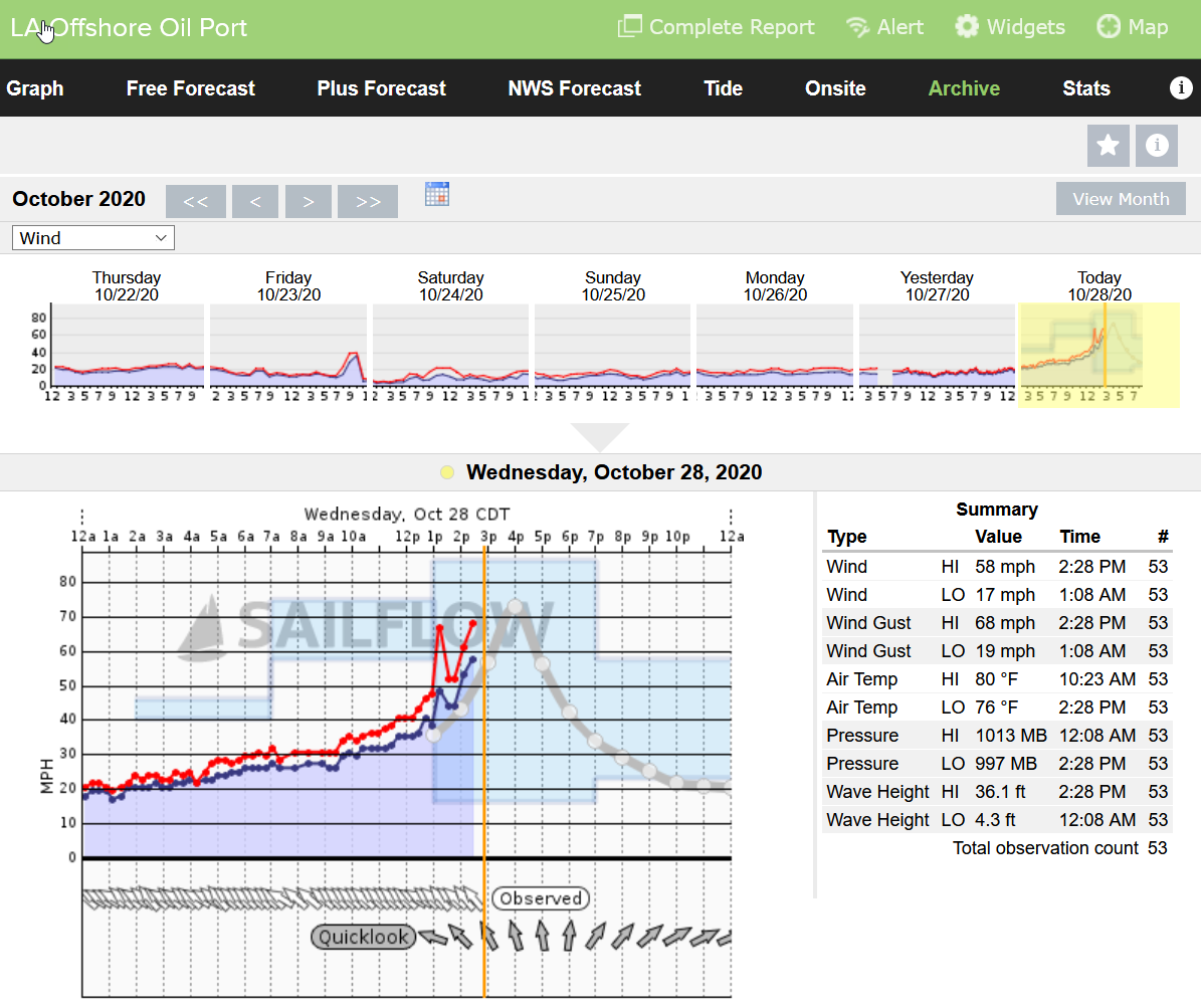
Looks like LA Offshore Oil Port just went offline. I think most in the area have dropped in last 30 minutes or so.
36.1 ft wave height. Whew, wonder how that will translate with any storm surge.
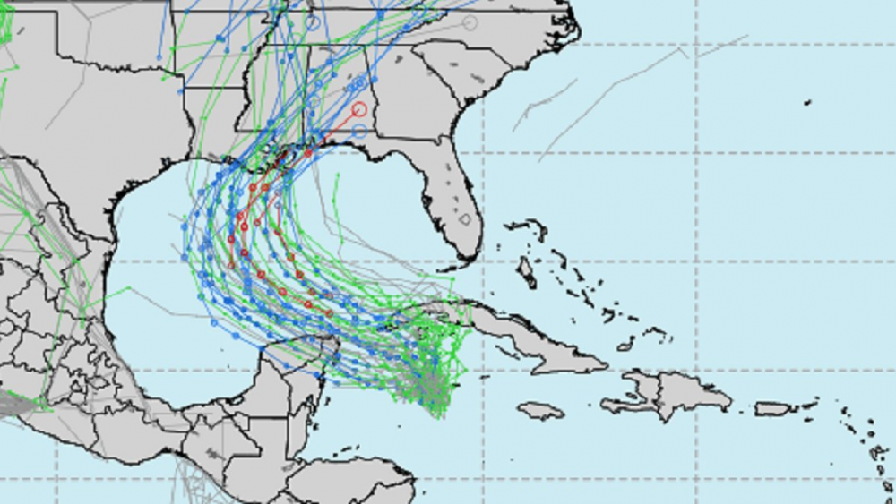
Look at this!!!
.-
2
-
-
-
Looks like these are flagged but it makes one wonder what they’ll find in the NE pass.

.
-
-
MOB has a decent write up about some of the inland affects below in last nights ST disco...
SHORT TERM /Wednesday night Through Thursday night/...Bands of
heavy rain and gusty winds will increase across the area on
Wednesday night as Zeta approaches the local area from the
southwest. At this time, landfall is forecast to occur in southeast
Louisiana sometime early Wednesday evening and then lift northeast
across southeast MS and into parts of southwest AL Wednesday
night. Tropical storm conditions (strong wind gusts and heavy
rain) will spread northeast across our forecast area Wednesday
evening into the early predawn morning hours Thursday. This system
will be interacting with a cold front and broad region of
associated diffluence aloft, so it is unlikely we see the typical
decay after landfall that we would see in storms earlier in the
season. In fact, model soundings continue to suggest upwards of 80
to 100 knots of flow in the eastern quadrant just off the surface
(925-850 mb layer) persisting well after surface winds have
weakened as Zeta moves inland over interior southeast Mississippi
even up into central Alabama. This will serve as a source of
momentum for heavy convective bands to transport to the surface.
Therefore, while locations along and west of I-65 will have the
greatest chance of seeing sustained tropical storm conditions
Wednesday night, can`t rule out frequent strong gusts to tropical
storm force farther east as well. As a result, a Tropical Storm
Watch has been issued for the entire local area. a weakening Zeta
accelerates quickly northeastward and by early Thursday morning
Zeta is expected to be over northeast AL and moving rapidly away
from the area with winds and rains gradually subsiding during the
day on Thursday.
.
-
2
-
-
-
Recon just arrived, let’s see what they find.
. -
Hello!
-
1
-
-
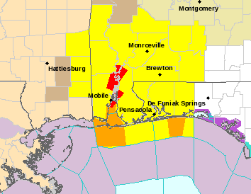
Multiple warnings popping up in this watch area. More added after this screenshot!
-
On the ground obs from well outside the cone: We have gorgeous outflow clouds and tropical soup at the lower levels here in Navarre.
.-
3
-
-
-
Yikes!
064
WTNT41 KNHC 062034
TCDAT1
Hurricane Delta Discussion Number 9
NWS National Hurricane Center Miami FL AL262020
500 PM EDT Tue Oct 06 2020
Shortly after the release of the 1500 UTC advisory package, the
NOAA Hurricane Hunter aircraft measured a peak flight-level wind
of 132 kt, and during its final passage through the northeast
eyewall around 1700 UTC it reported a peak SFMR wind of 121 kt.
The aircraft continued to report an extremely small 4-to-5-nmi-wide
eye. The central pressure did level off somewhat on the final
couple of penetrations, with the latest reported central pressure
at 956 mb. The initial wind speed was raised to 120 kt on the
earlier intermediate advisory, and has been set at 125 kt for this
advisory. The next reconnaissance aircraft mission into the
hurricane is scheduled for this evening.
There has been no evidence of an outer eyewall from the aircraft
reports or earlier radar imagery from Grand Cayman. As a
result, some additional strengthening is likely to occur before
Delta reaches the northeastern coast of the Yucatan peninsula late
tonight or early Wednesday. The NHC intensity forecast is once
again a little above the various intensity aids until landfall in
Mexico. When the small inner core of Delta moves over land,
weakening is expected, but warm waters and low vertical wind shear
over the southern Gulf of Mexico should support re-strengthening,
and a second peak in intensity is likely when Delta is over the
central Gulf of Mexico in 48-60 hours. After that time, increasing
southwesterly shear and the cooler shelf waters over the
northern Gulf are expected to cause some reduction in wind speed.
The global models, however, depict a significant increase in the
size of Delta's wind field while it is over the Gulf of Mexico,
which increases the spatial extent of the storm surge and wind
threats for the northern Gulf coast. So regardless of Delta's
final landfall intensity, the projected large size of the hurricane
is likely to result in a significant storm surge and wind event for
portions of the northern Gulf coast later this week.
Delta has been moving steadily west-northwestward today at 300/15
kt. The track forecast reasoning remains unchanged from the previous
advisory. A mid-level ridge over Florida and the northeastern Gulf
of Mexico is expected to continue steering Delta west-northwestward
during the next 36-48 hours. After that time, a developing trough
over the south-central United States should cause Delta to turn
northward, and by Friday the hurricane is forecast to begin
accelerating northward or north-northeastward ahead of the trough.
This motion will bring Delta onshore along the northern Gulf coast
between 72 and 96 hours. The dynamical models continue to be
tightly clustered through 48-72 hours with some increase in spread
thereafter. The overall trend in the guidance has been slightly
westward, and the new forecast has been adjusted accordingly and
lies near the middle of the envelope. Supplemental upper-air balloon
launches at 0600 and 1800 UTC have begun at upper-air sites across
portions of the southeastern United States. In addition, a NOAA
G-IV synoptic surveillance mission is in progress and should provide
additional data for the 0000 UTC cycle of the dynamical models.
Key Messages:
1. Life-threatening storm surge and potentially catastrophic wind
damage are expected within portions of the northern Yucatan
Peninsula of Mexico beginning tonight. All preparations to protect
life and property should be rushed to completion.
2. Heavy rainfall will affect portions of the Cayman Islands,
western Cuba and the northern Yucatan Peninsula through midweek.
This rainfall could lead to significant flash flooding and
mudslides. The potential for heavy rain, flash and possible minor
river flooding will increase across portions of the central Gulf
Coast, Tennessee Valley, and southeastern United States as Delta
moves inland later this week.
3. There is an increasing likelihood of life-threatening storm surge
and dangerous hurricane-force winds, especially along the coasts of
Louisiana and Mississippi, beginning on Friday. Residents in these
areas should ensure they have their hurricane plan in place and
follow advice given by local officials. Storm surge and hurricane
watches will likely be issued for portions of the northern Gulf
Coast on Wednesday.
FORECAST POSITIONS AND MAX WINDS
INIT 06/2100Z 18.9N 84.1W 125 KT 145 MPH
12H 07/0600Z 20.2N 86.1W 135 KT 155 MPH
24H 07/1800Z 21.8N 88.8W 105 KT 120 MPH
36H 08/0600Z 23.0N 91.1W 110 KT 125 MPH
48H 08/1800Z 24.4N 92.6W 115 KT 130 MPH
60H 09/0600Z 25.9N 93.2W 115 KT 130 MPH
72H 09/1800Z 28.0N 92.9W 110 KT 125 MPH
96H 10/1800Z 32.4N 90.9W 55 KT 65 MPH...INLAND
120H 11/1800Z 35.5N 87.3W 20 KT 25 MPH...POST-TROP/REMNT LOW
. -
145/956 @ 5
. -
He’s not going to miss penetrating something this tight and cute
I see what you did here!!! Lol
.


Tropical Storm Eta
in Tropical Headquarters
Posted
Welcome to Hurricane season 2020!