

NavarreDon
-
Posts
2,819 -
Joined
-
Last visited
Content Type
Profiles
Blogs
Forums
American Weather
Media Demo
Store
Gallery
Posts posted by NavarreDon
-
-
Here is some thoughts from the MOB office on where they currently think the surface low is headed thru their FA. This will pertain more to the Upstate SC & WNC crew. It might be worth the read for you guys up north. Down here I have to wonder if we will ever dry out!
LONG TERM /Friday Through Monday/...Another mild day expected
Friday with daytime high temperatures climbing into upper 50s to
lower 60s...within a few degrees of seasonal norms. Easterly
surface winds will gradually strengthen during the afternoon and
become southeasterly in response to an approaching low pressure
system to our west. By Saturday night, an eastward propagating
cold front is projected over the Western Gulf with a surface low
just offshore of the Southwest Louisiana and Texas border with a
warm front extending eastward across the Northern Gulf. There
still remains a lot of variability between the models on the
evolution of this system as well as its timing. Have trended this
forecast package more towards the GFS and UKMET solutions of
keeping the surface low and attendant warm front generally along
the coast as if moves east, but did address the potential for more
convection inland with increased PoPs and isolated thunderstorms
due to the more northerly track advertised by the ECMWF, GEM and
some of the GFS ensemble members. It currently looks like the best
chance of precipitation will occur Saturday afternoon through
Saturday night with rainfall amounts heaviest closer to the coast
where forcing for ascent will be strongest and precipitable water
amounts will approach two inches. Rainfall amounts of 2 to 4
inches appear possible at this time along the coast tapering off
to 1 to 2 inches inland. Indications are this system will be
relatively fast moving so not anticipating widespread flooding but
localized flooding will remain possible. Another critical concern
is whether or not the warm sector shifts inland if it does, this
could lead to strong to possibly severe thunderstorms especially
along the coastal counties of Alabama and the Western Florida
Panhandle. We will continue to monitor trends and adjust
accordingly. For now, continued with the previous thinking of the
surface low moving east along the coast with most of the surface
based instability remaining offshore.
-
 4
4
-
-
I'm over 4 years removed from Weaverville & reading a LT disco like this still gets me excited! Some of you guys are gonna be living the dream come the weekend! (Jason i agree with HT, I see no reason why the Asheville crew would get dry slotted with this one)
.LONG TERM /FRIDAY THROUGH MONDAY/...
As of 340 AM Tuesday: Confidence continues to grow that a
significant winter storm will impact portions of the forecast area
beginning sometime Saturday and continuing in earnest Sunday and
possibly evening Monday. However, the details this far out are still
sketchy at best as any small changes in the track or strength of the
storm system or parent sfc high pressure to the north could make the
different be mostly a cold rain or significant ice/snow. The
greatest confidence in significant ice/snow accumulations continues
to be across the mountains and east facing foothills where WPC
continues to advertise a 50-70 percent chance of winter storm
warning level ice/snow accumulations. The latest forecast blends the
EC and GFS, leaning towards the slower EC in line with neighboring
offices and WPC. Now for the forecast details as they stand now.

Zonal flow will continue into the extended time frame Friday with
surface high pressure continue to exert its influence across the
region into Saturday. The net result will be fair skies with
reinforcing cool and dry air Friday night as air damming or a wedge
sets up east of the mountains Friday night, which will likely
persist through the weekend. This will set the stage for the
potentially significant winter storm as wet bulb temperatures fall
into the mid 20s to mid 30s across the FA Saturday. An amplified
upper trough will push through the southern Plains states into the
Deep South Friday into Saturday with an attendant sfc low pressure
system riding the Gulf of Mexico coastline before moving off the
Southeast coastline Sunday. The CAD and increasing clouds and precip
Saturday into Sunday will lock in cold temps with lows only in the
20s to 30s and highs only in the 30s to low 40s this weekend. This
scenario looks to favor mostly wintry precipitation and possibly
mostly snow across the mountains with a mix bag of precipitation
across the NC Piedmont with some combination of rain or mixed
precipitation further south into the Upstate of SC and northeast GA.
While its too early to get into precipitation type details, wouldn`t
be surprised to see more wintry look to precip across the region
near onset and towards the end with more rain or ice in between when
the storm is closest and pushes warmer air at mid levels (aka warm
nose) into the region. The heaviest precip currently looks to take
place Saturday night into Sunday. In addition to the wintry this
weekend, model guidance shows some potential for significant snow on
the backside of the storm late Sunday into Monday. Now is the time
to put your winter weather plan together to be prepared for this and
future potential winter storms.
-
1
-
-
2 hours ago, maytownpawx said:
Good morning everyone. My wife and daughters will be driving from Central PA to Boone this weekend. They'll be coming down I-77 and then I think it's 421 from there all the way into Boone. What is 421 like in winter events? Is this a route that is usually kept pretty clear? Also...as of right now, what does the timing look like for onset of the steadiest snow?
I'm trying to figure out if and when it would be best for her to travel. It's just about 500 miles from up here and i'm hoping to maximize her mileage in good weather.
Thanks in advance to anyone who can help me out with advice. I appreciate it!
Sounds like you've gotten some good info but wanted to add a couple things. Your family is driving into the most prepared region in the South for handling winter weather & winter road maintenance. That being said it is probably nothing like you're used to in Central PA. If the snow, IP, ZR, comes in hard the roads pay the price of not enough equipment or manpower to keep up. Your family is also coming into a region with many micro climates (wide variations of weather over short distances). Finally what kind of vehicle they are traveling in will be critical also ie: 4WD, AWD, FWD, RWD. The Mets @ GSP & RNK are some of the best in the NWS due to dealing with the areas wide variety of weather and their disco's should be watched closely. Boone is under the RNK watch but with a storm riding in from the SW you should get a great idea about timing from GSP. As has been pointed out the best advice, in the area they will be traveling, is to beat the storm in! Good luck & safe travels.
-
Same here. Old timers say that if you get flurries on a Monday, you'll get a monster gulf low snow storm on Saturday.
Just enough time for Woodfin priorities!!!
. -
I used to love GSP's LT disco's like this one when I lived in Weaverville! Some will be disappointed but some are going to cash big time unless there is a dramatic change with this set up.
.LONG TERM /THURSDAY NIGHT THROUGH MONDAY/...
As of 230 PM Monday: No major changes to the overall forecast from
the 12z guidance. If anything, they continue to trend a little
slower/delayed on the onset of precip, and also a little heavier in
QPF. The 12z ECMWF has come in more northerly/inland with the sfc
low track, and results in warmer thicknesses across the FA thru the
event. This allows a stronger warm nose, and perhaps, more of a
mixed bag of p-types, versus more ra/sn that previous runs
suggested. I opted to blend a little 12z ECMWF into the partial
thickness p-type nomogram tool for this forecast. Still get a lot of
snow in the mountains and the I-40 corridor with this solution, but
if the new ECMWF trend holds, these values will likely be a lot
lower, due to the sleet/frza mixing in. With all that said, it still
looks like a significant winter storm on tap for most of the
mountains and adjacent foothills in NC, while the Piedmont south of
I-40 is highly uncertain. Temps will start out below normal Friday,
as a reinforcing cold front pushes thru. Then classic cold air
damming sets up Friday night thru Sunday, as a strong sfc high
builds in across the Ohio Valley to the Mid-Atlantic. The heaviest
precip looks to be mainly Saturday night into early Sunday, but that
time may change slightly as we get closer to the event. Temps will
be tricky with the CAD. I stuck close to WPC, but these may be too
warm within the heart of the CAD wedge.
-
1
-
-
Pretty darn exciting LT disco by GSP for this far out!
.LONG TERM /THURSDAY THROUGH SUNDAY/...
As of 410 AM Monday: Threat for significant winter weather next
weekend continues, especially for the NC mtns and adjacent piedmont
and points north. However, confidence is very low on the exact
details. The 00Z EC was preferred for the extended given its better
consistency and it falls between the faster and warmer operational
GFS and the slower and colder GFS ensemble members. Thursday into
Friday will be the quiet before the storm. Zonal flow aloft will
prevail during this time with surface high pressure weakening and
shifting southeast of the FA Friday. A northern stream disturbance
passing to the Thursday night north may bring some clouds to the
mountains with an outside shot at a few snow showers. Otherwise
expect increasing clouds by late in the day Friday ahead of a
surface low pressure system developing along the northwestern Gulf
of Mexico. Temperatures will warm some into Friday but will likely
remain below normal.

The surface low is currently expected to track near the northern
Gulf Coast Friday into Saturday before crossing FL and arriving
somewhere near the Southeast coast Sunday. the timing and location
of the low would support continued increasing clouds with
precipitation starting sometime Saturday, possibly late in the day.
Most guidance shows a 1030mb+ sfc high pressure system building into
the Mid Atlantic states Friday night into Saturday just ahead of the
storm system. This supports much colder air filtering into the region
by Saturday with highs expected to only be around 40, setting the
stage for the potentially significant winter storm. Saturday night
into Sunday currently look like the period for the most significant
precipitation with a strong southerly low level jet pumping moisture
into the region above the cold dome of high pressure wedging down
east of the mtns. Much uncertainty exists with the eventual
precipitation type across the region. At this time it appears that
the biggest ice/snow issues would be on the front end of the storm
system. Although, if the fairly strong sfc high pressure system gets
locked into the Mid-Atlantic states on some models suggest, then
significant snow and ice will be possible, especially across NC.
Although at least light snow and especially ice accumulations are
possible even across southern portions of the FA as well. The
forecast will likely change multiple times this week, but now is the
time to begin putting a winter weather plan together for this
potentially significant winter storm.
-
2
-
-
42 minutes ago, NC_WX10 said:
A little concerned about too much suppression for those of us in the northern mountains. Trends are definitely in the favor of SW NC imo.
Synoptics & climo might argue against this. I'd be really leery of a cold rain in the Hayesville, Murphy area. Maybe even a rain to snow event in the Franklin area (elevation dependent in the SW). Central & Northern Mountains could get clobbered!
-
Hey guys!,
Just wanted to jump in and say.....raise those eyebrows. This has the makings of a Mountain special. It will be interesting to watch the placement of the key players as time progresses. Right now it looks like the typical set up for big Southern low snow. I will be bumping in with some thoughts periodically. If I was most of you I'd be pretty excited to track this. As always there is the bust potential but someone should cash!
-
1
-
-
1 hour ago, CAD_Wedge_NC said:
To find the wet-bulb temperature you take the difference between the actual temperature and the dew point and divide it by 3. Then you subtract it from the actual temp. In other words a temp of 42 degrees with a dew point of 30 degrees would yield a wet bulb of 38 degrees. This is a down and dirty way of knowing what you will be able to achieve by evaporational cooling from precipitation.
-
 2
2
-
-

Up to 40% 2 day & 70% 5 day.
.
-
-
-
-
NHC not buying the stall and SW movement in their 5pm map

This would be a bad setup for the Mnts in WNC especially along the escarpment!
. -
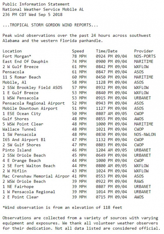
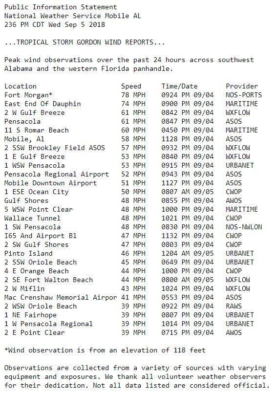
Up to 7” here at the house in Navarre. This matches up well to storm accumulation on radarscope. Rain is starting to wain out in the Gulf.

.-
1
-
-
Over 10” of rain in Pensacola area so far. Sadly one fatality as a child was killed when a tree fell on a mobile home in Escambia county (W Pensacola area). The river of moisture is just to the west of us here in Navarre, we are @ 5” currently.
. -
Multiple tornado warnings now in Santa Rosa county in FL.
.-
1
-
-
Here we go tornado warning for this cell that just went thru here. It was hairy for a minute!!!

.-
1
-
-
Flash Flood Warning
Flash Flood Warning
ALC003-FLC033-113-050715-
/O.NEW.KMOB.FF.W.0019.180905T0124Z-180905T0715Z/
/00000.0.ER.000000T0000Z.000000T0000Z.000000T0000Z.OO/
BULLETIN - EAS ACTIVATION REQUESTED
Flash Flood Warning
National Weather Service Mobile AL
824 PM CDT TUE SEP 4 2018
The National Weather Service in Mobile has issued a
* Flash Flood Warning for...
Southern Baldwin County in southwestern Alabama...
Central Santa Rosa County in northwestern Florida...
Southern Escambia County in northwestern Florida...
* Until 215 AM CDT.
* At 822 PM CDT, Doppler radar indicated thunderstorms producing
heavy rain across the warned area. Two to four inches of rain have
fallen. Flash flooding is expected to begin shortly.
Additional rainfall amounts of three to six inches are possible in
the warned area over the next six hours.
PRECAUTIONARY/PREPAREDNESS ACTIONS...
Turn around, don`t drown when encountering flooded roads. Most flood
deaths occur in vehicles.
Be especially cautious at night when it is harder to recognize the
dangers of flooding.
.-
1
-
1
-
-
Wind has backed off some here in Navarre but, the Gulf is open for business with the precip. I'm a little surprised at the amount of rainfall so far.
-
1
-
-
Good sig of rotation moving toward your location.
Nice call, noticeable increase in rain & wind. Probably gusts up to 50+ and a tornado watch is now in affect.
. -
This is for perspective of my location.

.-
1
-
1
-
-
Getting our worst weather currently with sustained wind of 30mph with gusts of 45mph here at the house. Went to the beach about an hour ago and took some vid & pics.


.
-
4
-
1
-
-
I’m in Fort Walton Beach at work, getting ready to head home to Navarre in about an hour. It’s been raining for about 3hrs with a 15-20 mph wind, gusts to around 30 so far.
.


2018/2019 Mountains and Foothills Fall/Winter Thread
in Southeastern States
Posted
This is a carbon copy of the WPC's %'s.