

NavarreDon
-
Posts
2,819 -
Joined
-
Last visited
Content Type
Profiles
Blogs
Forums
American Weather
Media Demo
Store
Gallery
Posts posted by NavarreDon
-
-
Gulf convection always disrupts the transport. I've heard it a hundred times after they say "we dodged the bullet" because of the thunderstorms down south.
I'm a long way from the escarpment and that cuts totals here too. You can see the sharp cutoff near the TN line which is only 6 miles from me as the crow flies. I'm thinking maybe 4 to 6 for mby, GFS has me at 5. You foothills guys and girls are going to get crushed.
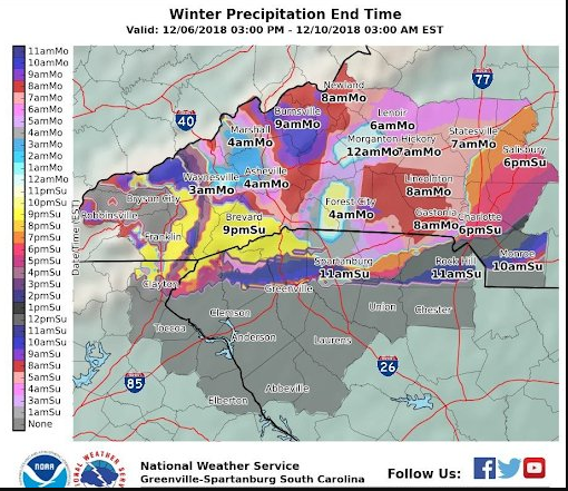
And now for a little color, a link to Rays call map.
http://grads.raysweather.com/modelData/event.png
Joe, I’ll bet you a bottle of Makers you exceed your predictions!
. -
Guys I’m not one for hyperbole & things are always fluid but, this has all the makings of an amazing event! I hope all of you exceed your expectations and we’re able to reference the December 18 storm for years to come!!! Good luck and I’ll be living vicariously through all of you.
.-
 1
1
-
-
We do need to watch this. But seems that given the moisture transport mechanism off of the Gulf and Atlantic, perhaps this won't be too big an issue.
Been busy at work but MOB is not super worried about it down this way.
.-
1
-
-
Again to piggy back on what HT has been say for the past several days. Here is MOB's short term for our area. This is the fire hose he has been talking about. In this type of set up the QPF transports up to your region.
.SHORT TERM /Saturday Through Sunday night/...Widespread rainfall
spreads from west to east across the region Saturday through
Saturday night as a surface low pressure system moves eastward
along the coast from LA into the Western FL panhandle.

Deep layer moisture, with precipitable water values consistently
advertised by the GFS to climb to around two inches, coupled with
large scale forcing for ascent should lead to periods of heavy
rainfall. Widespread rainfall totals of 2 to 4 inches with
isolated totals as high as 6 inches remain possible. Current
trends indicate that the heaviest rainfall will fall over
Southeast Mississippi during the late morning hours tapering off
during the early evening hours, Alabama counties West of the I-65
corridor during the afternoon through early evening and Western
Florida Panhandle counties and Alabama counties East of the I-65
corridor mid to late afternoon into the late evening hours.

Concerns for potential flooding remain especially over the area
southeast of a Mobile to Andalusia line due to last weeks heavy
rains last week keeping the soils in this area relatively moist.
Heavy rain fall occurring within short period of time is possible
which could create areas of flash flooding. Furthermore,
widespread rainfalls of 4 inches could lead to minor and possibly
moderate river flooding in this area. A Flash Flood Watch may
be issued for this area in the next 12 hours. Based on the
current forecast track of the surface low, a marginal severe
threat will exist along the coast just ahead of the surface low
in the warm sector. The primary risks being brief tornadoes and
damaging straight line winds Saturday and Saturday night.

A high risk of rip currents will exist along area Gulf beaches
from Friday night through Sunday night. High surf, and minor
coastal flooding will also be possible Saturday afternoon into
Saturday night.

As the region remains under the base of the upper level trough, a
few sprinkles and a lingering chance of some light rain will
continue Sunday through Sunday evening/night time frame. /08
-
1
-
-
4 minutes ago, HurricaneTracker said:
 1 minute ago, ncjoaquin said:
That meets the old E/E money in the bank.
It really doesn't get much better than this! I have no dog in this fight so to speak & I get really excited looking at these 2 side X side!!!
-
2
-
-
14 hours ago, BretWheatley said:
This can't be right... ?
 12 hours ago, NavarreDon said:
Wanted to say a couple things about GSP. 1st off you have different Mets writing AFD’s and they have different perspectives. While they collaborate the lead forecaster has the most input. 2nd. This is essentially their 1st call map and will change at least 4 more times before the storm arrives. 3rd they are some of the best in the business but are human and prone to error (anyone remember the farmer reference in the AFD from the Christmas 2010 storm). I would much rather have them bust calling for less and getting more than vice versa. Take a breath and let’s see where it goes.
.1 hour ago, BretWheatley said:And.... we’re back!
I did want to post this and just say remeber to take a deep breath when things don't go your way & there's still time for change. Things may change again but the chase is a huge part of the fun. Try to make sure your highs aren't to high & your lows aren't to low.
-
Nice!....giddy up!!!

.SHORT TERM /SATURDAY THROUGH MONDAY/...
As of 330 AM Friday: Confidence is high enough on significant
snow/wintry precip in the heart of the expected cold air damming,
that after collaboration with WFO RNK, portions of the watch have
been upgraded to a winter storm warning. The rest of the watch will
be left as is, as there is still some time to fine tune details.
Overall, no big surprises in the 00z guidance. If anything, they`ve
trended a little wetter. Adequate QPF for winter storm warning
criteria accums is not an issue. The two biggest concerns are the
evolution of a warm nose above the CAD, and the sfc-based warm layer
around the periphery of the wedge. These will determine the p-type
thru the event. I opted to take a 50/50 blend of the GFS/NAM
profiles. The NAM has the much stronger warm nose, bringing it even
into the central NC mountains for a time on Sunday.

So precip should start expanding north and east across the forecast
area during the day on Saturday. Thermal profiles suggest most of
the precip will start out as rain, except in the central and
northern mountains and adjacent foothills in NC. By early Saturday
evening, CAD should be really strengthening across the Piedmont, as
precip rates will be at their highest and the ~1036 mb parent high
reaches PA. The wedge looks to advect enough cold/dry air to
wet-bulb temps down into the upper 20s to mid 30s across the entire
Piedmont by daybreak Sunday. This will be about the time the warm
nose will punch in from the east, resulting in a wintry mix of
rain/sleet/freezing rain. Meanwhile, most of the I-40 corridor looks
to remain all snow. The sfc low will track from the FL panhandle
east to off the Georgia coast by Sunday aftn. The NAM has a dry air
punching in from the southwest, which could cut off ice nuclei
activation and turn snow/sleet to freezing rain/drizzle. However,
the GFS/ECMWF/CMC all seem to keep deeper moisture within a
developing deformation zone thru Sunday night. For now, I keep ice
nuclei active thru the event. This allows snow totals to continue to
pile up.

Finally, Sunday night thru Monday, as the sfc low deepens off the
Carolina coast, cold air spills in behind the circulation and should
erode the warm nose aloft. Thermal profiles turn into ra/sn, with
some snow possible across even in the southern Upstate. However,
precip rates should be very light by this point. Temps will hover
mainly in the 28-35 deg range Sunday thru Sunday night, then rebound
slightly on the back side of the system on Monday to the upper 30s
to lower 40s.

We have expanded the watch to include the GA and SC mountains, along
with a tier of zones from Pickens to York County in SC, where
climatologically in CAD events should get higher wintry accums.
While the rest of the GA and SC Piedmont is still too low confidence
for a watch, but may need an advisory once the event is within 24
hours. Given the upward trend in QPF. Impacts from the combination
of what is expected to be a very wet snow, and icing in some areas,
look to be significant. Very windy conditions are expected Saturday
night and most of Sunday, which makes falling trees and power lines
likely.
-
URGENT - WINTER WEATHER MESSAGE
National Weather Service Greenville-Spartanburg SC
420 AM EST Fri Dec 7 2018
...MAJOR WINTER STORM TO IMPACT THE REGION THIS WEEKEND...
.Cold high pressure along the East Coast will interact with a
moist low pressure system moving out of the Gulf of Mexico
Saturday night into Sunday. Moderate to heavy precipitation will
fall as a mixture of snow, sleet, and freezing rain across the
region. Accumulations are expected to be greatest in western
North Carolina.
NCZ033-049-050-053-064-065-501-503-505-507-509-071730-
/O.UPG.KGSP.WS.A.0005.181208T1800Z-181210T1700Z/
/O.NEW.KGSP.WS.W.0006.181209T0000Z-181210T1700Z/
Avery-Yancey-Mitchell-Buncombe-Transylvania-Henderson-
Caldwell Mountains-Burke Mountains-McDowell Mountains-
Rutherford Mountains-Polk Mountains-
Including the cities of Ingalls, Banner Elk, Newland, Swiss,
Burnsville, Celo, Micaville, Ramseytown, Busick, Spruce Pine,
Poplar, Asheville, Brevard, Cedar Mountain, Little River,
Hendersonville, Fletcher, Dana, East Flat Rock, Tuxedo, Etowah,
Patterson, Jonas Ridge, Ashford, Sugar Hill, Woodlawn, Old Fort,
and Saluda
420 AM EST Fri Dec 7 2018
...WINTER STORM WARNING IN EFFECT FROM 7 PM SATURDAY TO NOON EST
MONDAY...
* WHAT...Heavy mixed precipitation expected. Total snow
accumulations of 10 to 16 inches and ice accumulations of
around one tenth of an inch expected.
* WHERE...Portions of western North Carolina, including the upper
French Broad Valley to the Northern Mountains and Northern
Foothills.
* WHEN...From 7 PM Saturday to noon EST Monday.
* ADDITIONAL DETAILS...Travel could be very difficult to
impossible. Road conditions could deteriorate as early as
Saturday evening, with highway travel continuing to be impacted
through early next week. Visibility may drop to less than a
half mile during periods of heavy snow. Widespread, prolonged
power outages are possible.
PRECAUTIONARY/PREPAREDNESS ACTIONS...
A Winter Storm Warning means significant amounts of snow, sleet
and ice will make travel very hazardous or impossible.-
1
-
-
5 hours ago, BlueRidgeFolklore said:
WTH is GSP doing?
I love GSP but they are taking a brutal beating on twitter for this map. I'm willing to bet this one may go into the closet, never to be seen again!
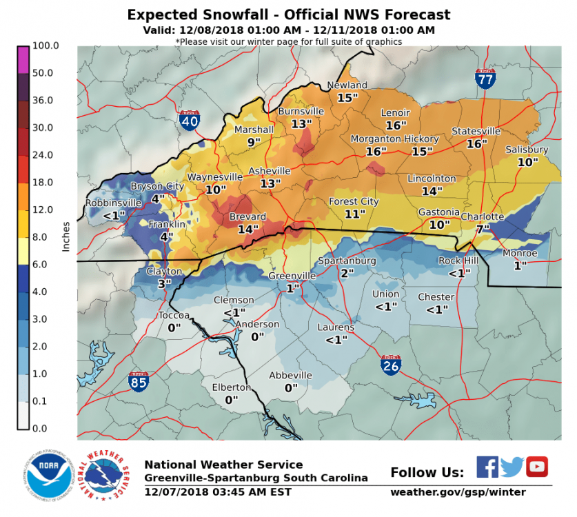
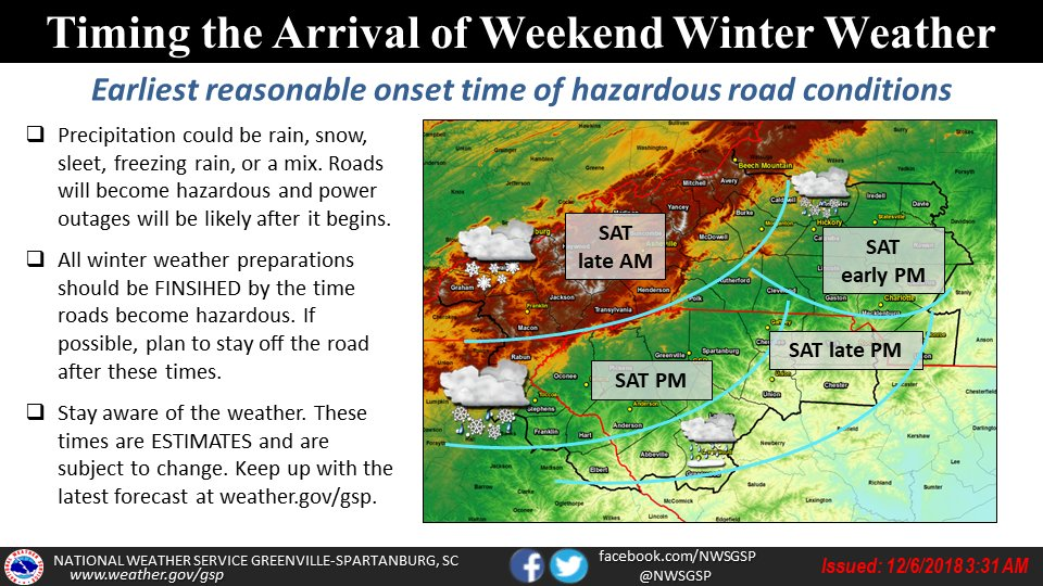
On a more serious note I have concerns that some places (eastern facing & above 3500') may be close to blizzard conditions during the event at times. I really feel like you will see some different maps, forecasts overnight & especially tomorrow from the crew in Greer if things hold the way they are.
-
1
-
-
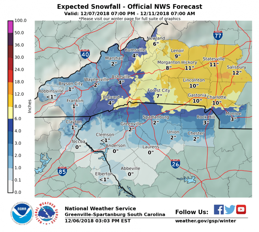
Wanted to say a couple things about GSP. 1st off you have different Mets writing AFD’s and they have different perspectives. While they collaborate the lead forecaster has the most input. 2nd. This is essentially their 1st call map and will change at least 4 more times before the storm arrives. 3rd they are some of the best in the business but are human and prone to error (anyone remember the farmer reference in the AFD from the Christmas 2010 storm). I would much rather have them bust calling for less and getting more than vice versa. Take a breath and let’s see where it goes.
. -
As long as I’ve been on this board some people hug each model run. Here’s a friendly psa. Watch trends not individual model runs. No reason to cliff dive now.
As far N FB river valley goes after living there for 11 years I will be stunned if their is freezing rain issues or major dry slotting. Not saying it won’t happen but I think it’s unlikely.
Take a breath, the chase is part of the fun!
.
-
2
-
-
-
I realize we're all big boys & girls with the capability to find it own our own but the ST disco from GSP is well......simply stunning! It needs to be posted for posterity. Even a mention of the B word!
.SHORT TERM /FRIDAY NIGHT THROUGH MONDAY/...
As of 355 AM EST Thursday: High confidence that a nearly ideal
synoptic set up for widespread and significant winter weather will
commence across the forecast area this weekend and possibly continue
into early next week. The highest in significant winter weather is
placed across the mountains foothills and NC Piedmont along and
north of I-40 where snow is expected to be the dominant
precipitation type, although periods of sleet and freezing rain are
also likely, especially outside of the mountains. Moderate
confidence for significant winter weather exists in the SC/NC
Piedmont along and north of I-85 and south of I-40 mainly east of I-
25. South of I-85 is not out of the woods with periods of moderate
to heavy ice and/or snow possible, but rain is expected to mix in
most often here, likely limiting ice/snow accumulations and related
impacts.

The expected overall synoptic setup has not really changed much for
several days, although model guidance has fairly uniformly tracked
track of the winter storm a bit further south and therefore leading
to snow and mixed precip types becoming more likely a bit further
south. A key to the upcoming winter storm is that cold air will be
locked in place across the region as confluence aloft ahead of the
system maintains a 1030+ mb W-E elongated sfc high pressure system
to our north with cold air damming (CAD) persisting through most of
the event. Good model consensus shows sfc low pressure riding along
the fringe of the strong high, initially along the Gulf Coast
Saturday before riding along or just off the Southeast Coastline
while intensifying Sunday. This setup will bring light to moderate
precip overspreading much of the sometime Saturday afternoon or
evening before becoming heavy at times overnight into Sunday. The
latest NAM indicates very dry air courtesy of the CAD possibly
delaying precip onset, especially across NC foothills, Piedmont and
northern mountains. A strong low level jet of 40+ kt is expected to
push through the region Sunday bring breezy conditions to many
location and gusty winds to the mountains above 3K or 4K feet where
wind gusts in excess of 40 mph are likely. This combined with period
of heavy snow may support at least brief blizzard conditions,
especially across east facing mountains. The strong low level jet
will also support an elevated (700-800mb), but now somewhat cooler
warm nose which will likely increase the icing threat which model
guidance and climatology would suggest would change somewhere
between the I-85 and I-40 corridors, lasting at least 3-6 hours. The
timing of the change over is likely sometime late Sunday night
though early evening and would like be limited across the mountains,
although sleet and freezing rain may mix in at times during this
period, especially south of I-40.

The CAD will likely gradually dissipate late Sunday into Monday but be
replaced by cold air filtering in behind the storm. Any ice should be
large over during this time with snow the predominate type area-wide,
except during the afternoon when rain may mix in at times outside of
the mountains mainly into the Upstate of SC and northeast GA. A
deformation zone with banding precip is possible during this time,
but there is still some uncertainly where exactly sets up and how
much precipitation we may see. The bottom line is the additional
snow is possible just about anywhere during this time.

Melted snow/ice or liquid precip storm total amounts continue to be
around 2 inches across most of the forecast area with local amounts
approaching 3 inches possible south of I-85 and across higher east
facing mountains due to upslope enhancement. Early estimates
continue to place snow amounts between 10 and 20 inches across the
mountains, foothills Piedmont northwest of I-85. Local 20+ amounts
are possible across higher east facing mountain and foothill
locations. Dangerous freezing rain and sleet accumulations in excess
of one half an inch continue to be possible with the high totals and
therefore impacts between I-85 and I-40 outside of the mountains.
Although latest model trends suggest areas closer to I-85 might have
the most cause for concern.

the bottom line is that a potentially very dangerous winter storm
looms for much of the forecast area this weekend. And as the day
shift yesterday put it, this could be a once-in-a-generation event
for areas that experience mostly snow and ice. Now is the time to
prepare. Finish preparations by Friday as if this storm speeds up
Saturday may be too late, especially for the Upstate of SC into
northeast GA.
-
And now the Disco has entered the ST, it just gets better & better. I even see the B word! Hold your socks fellas cuz this one may knock your shoes off!!!
.SHORT TERM /FRIDAY NIGHT THROUGH MONDAY/...
As of 355 AM EST Thursday: High confidence that a nearly ideal
synoptic set up for widespread and significant winter weather will
commence across the forecast area this weekend and possibly continue
into early next week. The highest in significant winter weather is
placed across the mountains foothills and NC Piedmont along and
north of I-40 where snow is expected to be the dominant
precipitation type, although periods of sleet and freezing rain are
also likely, especially outside of the mountains. Moderate
confidence for significant winter weather exists in the SC/NC
Piedmont along and north of I-85 and south of I-40 mainly east of I-
25. South of I-85 is not out of the woods with periods of moderate
to heavy ice and/or snow possible, but rain is expected to mix in
most often here, likely limiting ice/snow accumulations and related
impacts.

The expected overall synoptic setup has not really changed much for
several days, although model guidance has fairly uniformly tracked
track of the winter storm a bit further south and therefore leading
to snow and mixed precip types becoming more likely a bit further
south. A key to the upcoming winter storm is that cold air will be
locked in place across the region as confluence aloft ahead of the
system maintains a 1030+ mb W-E elongated sfc high pressure system
to our north with cold air damming (CAD) persisting through most of
the event. Good model consensus shows sfc low pressure riding along
the fringe of the strong high, initially along the Gulf Coast
Saturday before riding along or just off the Southeast Coastline
while intensifying Sunday. This setup will bring light to moderate
precip overspreading much of the sometime Saturday afternoon or
evening before becoming heavy at times overnight into Sunday. The
latest NAM indicates very dry air courtesy of the CAD possibly
delaying precip onset, especially across NC foothills, Piedmont and
northern mountains. A strong low level jet of 40+ kt is expected to
push through the region Sunday bring breezy conditions to many
location and gusty winds to the mountains above 3K or 4K feet where
wind gusts in excess of 40 mph are likely. This combined with period
of heavy snow may support at least brief blizzard conditions,
especially across east facing mountains. The strong low level jet
will also support an elevated (700-800mb), but now somewhat cooler
warm nose which will likely increase the icing threat which model
guidance and climatology would suggest would change somewhere
between the I-85 and I-40 corridors, lasting at least 3-6 hours. The
timing of the change over is likely sometime late Sunday night
though early evening and would like be limited across the mountains,
although sleet and freezing rain may mix in at times during this
period, especially south of I-40.

The CAD will likely gradually dissipate late Sunday into Monday but be
replaced by cold air filtering in behind the storm. Any ice should be
large over during this time with snow the predominate type area-wide,
except during the afternoon when rain may mix in at times outside of
the mountains mainly into the Upstate of SC and northeast GA. A
deformation zone with banding precip is possible during this time,
but there is still some uncertainly where exactly sets up and how
much precipitation we may see. The bottom line is the additional
snow is possible just about anywhere during this time.

Melted snow/ice or liquid precip storm total amounts continue to be
around 2 inches across most of the forecast area with local amounts
approaching 3 inches possible south of I-85 and across higher east
facing mountains due to upslope enhancement. Early estimates
continue to place snow amounts between 10 and 20 inches across the
mountains, foothills Piedmont northwest of I-85. Local 20+ amounts
are possible across higher east facing mountain and foothill
locations. Dangerous freezing rain and sleet accumulations in excess
of one half an inch continue to be possible with the high totals and
therefore impacts between I-85 and I-40 outside of the mountains.
Although latest model trends suggest areas closer to I-85 might have
the most cause for concern.

the bottom line is that a potentially very dangerous winter storm
looms for much of the forecast area this weekend. And as the day
shift yesterday put it, this could be a once-in-a-generation event
for areas that experience mostly snow and ice. Now is the time to
prepare. Finish preparations by Friday as if this storm speeds up
Saturday may be too late, especially for the Upstate of SC into
northeast GA.
-
1
-
-
Great write up HT, very detailed and appreciated. I just want to piggy back on the fire hose part of the write up. This is the disco from MOB for our area. It will give you some insight into the downstream part of the storm.
SHORT TERM /Thursday night Through Saturday night/...A mid to
upper level zonal flow pattern will persist across the central
Gulf Coast region Thursday night through Friday, while surface
high pressure continues to ridge over the southeastern U.S. Cloud
cover will be on the increase across our forecast area through
Friday, but the forecast looks to remain dry as deeper moisture
remains to our west and northwest through Friday afternoon. Cool
temperatures continue with lows Thursday night in the 30s over the
interior, with lower to mid 40s near the immediate coast. Highs
Thursday should moderate into the upper 50s to the lower 60s.
The next upper level trough is forecast to move from the Desert
Southwest Friday evening to the vicinity the Mid-Mississippi and
Tennessee Valley region by Saturday night. An associated area of
surface low pressure should track eastward along the coastal
portions of Louisiana, Mississippi, Alabama, and northwest Florida
along a frontal boundary Saturday into Saturday night. Deep layer
ascent will spread into western and northwestern portions of our
forecast area Friday night into Saturday morning, then across the
remainder of the CWA Saturday afternoon into Saturday night ahead
of the approaching trough axis and low pressure system. Widespread
rain showers will impact the region Saturday into Saturday night,
and will keep categorical POPs in the 80-90% range during this
time frame. The primary concern with this event will be heavy
rainfall, as the latest medium range guidance continues to
advertise widespread 2-3 inches of rain over much of the region,
but there could be some localized amounts of 4-6 inches near the
coast which will be within a region of stronger forcing and
higher precipitable water values. Localized flooding/flash
flooding may become a concern near the coast, where soils remain
relatively saturated from the rainfall event last weekend. The
severe weather potential still remains more uncertain and
primarily relegated to areas near the immediate coast. There will
be plentiful deep layer and low level shear with this system, but
instability remains highly uncertain. A severe threat could
eventually impact locations near the AL coast and portions of the
northwest Florida panhandle Saturday afternoon into Saturday
night, where there are still some signs of a weak warm sector and
associated weak instability penetrating inland over this portion
of the area ahead of the low pressure system, and will continue
to monitor this potential over the next 2-3 days.
.-
1
-
 1
1
-
-
Just now, ncjoaquin said:
You are right. This is probably bonus snow this early in the winter. Good to have you here Met1985! You are our backbone.
Gonna be a good one for you Jason! Wouldn't trade the beach move for anything but, times like these I wish I was still on New Stock Rd! You're right it's great to see 85 sticking his pretty mug in this thread!
-
1
-
 1
1
-
-
Good Morning folks! When I read this LT disco from GSP it does nothing but tell me you guys are in for some early season fun.....buckle up!!!
.LONG TERM /FRIDAY NIGHT THROUGH TUESDAY/...
As of 350 AM Wednesday: Above normal confidence exists for a
significant winter storm across at least portions of the forecast
area this weekend and possibly lingering into early next week. This
is due to unusually good consistency between models and from run to
run really for several days now despite the storm system now pushing
into the southwest U.S. This has occurred in the past, especially
for unusually significant storms. This storm may fall in the unusual
significant category, especially across the mountains and foothills
as it seems to have all the necessary ingredients for a high impact
winter storm. This being said, below average confidence continues in
the exact forecast details and related potential impacts as
relatively minor shifts to the storm track or strength can lead to
significant changes where and how long wintry precip sets up.

High pressure will continue to nose into the Mid-Atlantic states
Friday night behind the cold front before wedging down east of the
mountains during the day Saturday, supporting colder and drier low
levels, ahead of this weekends storm system. The storm is expected
to slide along the Gulf of Mexico coastline Friday into Saturday
before turning the corner near the Southeast U.S. coastline by late
in the day Sunday. Increasing mid to high level clouds late Friday
night into Saturday will likely assist the CAD in locking in cold
temperatures with highs only in the 30s to around 40 or 15-20
degrees below normal. Increasing moist southerly flow enhanced by
isentropic lift up and over the established cold dome at the surface
will support increasing precip changes from the southwest through
the day. Saturday night into Sunday may be the most significant
precipitation of the storm as strong southeasterly 30 to 40 kt 850
mb winds originating from the Gulf of Mexico enhance moisture
transport. This flow is also perpendicular to the cold dome continue
to be supported by a 1030+ mb high to the north as well as the
perpendicular to the mountains which will enhance lift and therefore
precipitation intensity and totals across the region. Precipitation
types across the region is the most challenging aspect of this storm
as it appears areas along and northwest of I-85 will likely see at
least some wintry precip to the mountains which may experience
mostly snow and ice. Warmer air aloft (warm nose) may try to work
into the region with the heaviest precipitation Sunday into Sunday
evening leading to greater ice/rain potential at least briefly
across the region. The duration of precipitation types will be
critical as current liquid precipitation continues to fall in the 1-
2 inch range with uplope areas possibly seeing up to 3 inches. The
take home message is that were are potentially dealing with a
dangerous storm with significant snow and ice accumulation now
likely across the mountains and foothills and possible anywhere
along and northwest of I-85. Early estimates place a potential for
snowfall amounts in excess of 6 inches across the mountains and NC
foothills with ice accumulations possibly in excess of 1/2 of an
inch across NC foothills/piedmont, especially north of I-40. Now is
the time to put your winter weather plan together and prepare for
this potentially significant upcoming winter storm.

The low is expected to intensify fairly rapidly off and slow down or
stall off the NC/VA coast Monday guidance continues to show a
reinforcing short wave diving into the trough. This may support
enhancement of precipitation on the backside of the storm early next
week, leading to potentially additional wintry precip across the
region.
-
2
-
-
3 minutes ago, AirNelson39 said:
Hmm, Brad P on FB Live just now said even mtns will possibly change to rain at some point?? And def foothills and piedmont
I'm not implying they are similar events but, during the December 2009 storm we started as snow then went to rain then back to heavy snow. We ended up with 16" + 2" more of flow snow on the back side for a total of 18" in Weaverville. Could there be mixing.....sure. With the QPF amounts shown on most of the guidance how relevant can it be? I guess if 3' is your goal you're out of luck. If 12"+ makes you happy you'll have grins galore!!!
-
2
-
-
33 minutes ago, HKY_WX said:
Looks like I'll be setting up shop on valle crucis for this one guys... Going to start getting my chit together tomorrow. Just wish I knew some place in raleigh to get snow chains
Plan on being there for a while? LOL!!!
-
35 minutes ago, SnoJoe said:GSP seems to think it will only be all snow Sunday night. Leads me to believe we'll have temp issues here. We might be a little to far away from the CAD region. Anyhow, we'll see how it shakes out. Hope everyone sees something wintry. Looks like a nice little tease tonight before the bigger event this weekend.SaturdayA chance of freezing rain before 10am, then a chance of rain between 10am and 3pm, then a chance of rain, snow, and sleet after 3pm. Cloudy, with a high near 37. Chance of precipitation is 50%.Saturday NightRain, snow, and sleet likely before 7pm, then snow between 7pm and 2am, then snow and freezing rain after 2am. Low around 28. Chance of precipitation is 80%.SundaySnow and sleet likely before 11am, then rain and sleet likely between 11am and 1pm, then rain and snow likely after 1pm. Cloudy, with a high near 35. Chance of precipitation is 70%.Sunday NightSnow likely. Mostly cloudy, with a low around 27. Chance of precipitation is 60%.MondayA chance of rain and snow. Mostly cloudy, with a high near 38. Chance of precipitation is 40%.
Joe, I expect this forecast to be fine tuned many times before the event. At this point GSP is covering all the bases. I hope you've made a Woodfin run or are able to in short order. If I didn't have to work so damn much I'd be hitting you up for room and board during the event!!! Highly likely you will be giddy as a schoolgirl on a first date for this one!
-
For some if the old timers on the board Robert (Foothills) says their are some details as usual to get worked out but........This one has the potential to be truly historic for the Mnt. region!
-
3
-
-
Here ya go folks!
.LONG TERM /FRIDAY NIGHT THROUGH TUESDAY/...
As of 230 PM Tuesday: Still expecting a potentially significant
winter storm starting Saturday and possibly continuing into Monday.
However, the models continue to waffle a bit on the details. The
latest forecast blends the 12z ECMWF and GFS, which have both
trended a little south with the sfc low track across the Gulf
Coast/Deep South, resulting in slightly colder thicknesses. The 12z
guidance has generally trended upward on QPF, as has WPC. This looks
like a fairly heavy QPF event, if trends hold. The WPC days 4-7
winter outlook now shows 70-90 percent chance of winter storm
warning criteria ice/snow accumulations across portions of the NC
mountains from 12z Saturday to 12z Sunday, with additional amounts
likely from 12z Sunday to 12z Monday. One of the reasons the models
have trended wetter is that they show a strong secondary shortwave
that dives in behind the main southern stream wave on Monday. This
keeps a deformation zone over the area thru the day on Monday, with
thicknesses supporting mostly snow.

The set up still looks the same...a split flow regime across the
western CONUS with confluent flow and a northern stream trough in
the East. Sfc high pressure of 1032-1038 mb elongated east-west
across the Great Lakes supports classic/strong CAD. As the southern
stream wave ejects from the Four Corners region to the Southern
Plains, strong upglide and frontogenesis coupled with upper level
divergence should spread precip into the area sometime on Saturday.
The models continue to delay the onset a little with each run. The
brunt of the precip and strong CAD looks to be Saturday night thru
Sunday (again these times may slip further). The 12z ECMWF has a
very strong easterly jet on the north side of the low, resulting in
strong moisture transport. So this has a lot going for it, QPF-wise.
As for temperatures/thicknesses, it`s still so borderline with sfc
wetbulb temps and warm nose position and strength. Went with a
blend of 12Z ECMWF/GFS for the partial thickness nomogram technique.
Still looks like a wintry mix for much of the area, with possibly
heavy snow in the mountains and northern Foothills. Depending on the
strength of the CAD, Freezing rain could also be a bigger concern
across the Piedmont. Hopefully, things start converging on a
solution as we get closer to this weekend. But anyway, now is the
time to put your winter weather plan together to be prepared for
this upcoming and future potential winter storms.
-
9 minutes ago, BlueRidgeFolklore said:
.thumb.png.60efa2bcccfac6fa589bf6350f240c54.png)
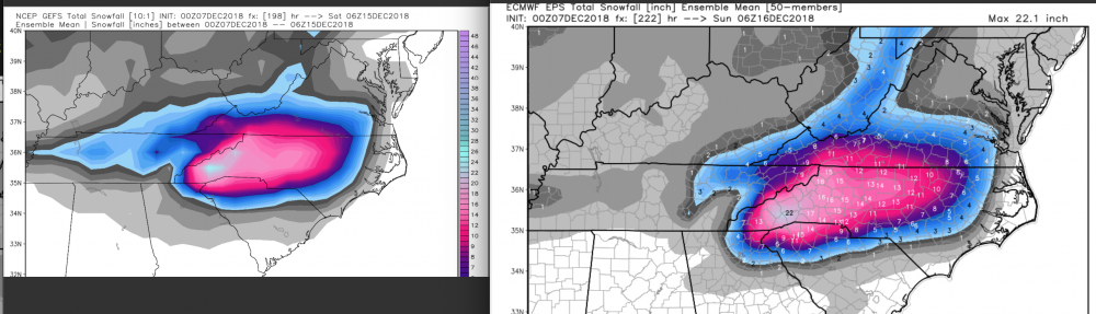
No matter what the outcome is with this system, staring at this map is hypnotic & makes me dizzy! You may never see something like this again in your lifetime.....32" @ KAVL is just mind boggling!
-
1
-
-
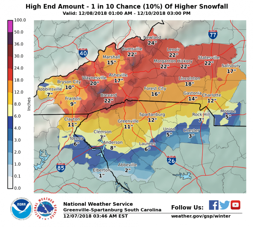
Model porn will keep you up at night! You fellas might want to pump the brakes a bit on the 2'-3' solutions. Not saying it won't happen or can't. I just would caution against verbatim model hugging. No matter what happens this is shaping up for many areas to cash with 12"+ totals which is amazing in it's own right! Exciting times in this thread for the next couple of days. Enjoy the ride folks!
-
3
-
1
-


.png.1623f0dfc82840e789e1ffca4b1f55d8.png)
2018/2019 Mountains and Foothills Fall/Winter Thread
in Southeastern States
Posted
Just wanted to post MOB's thoughts on downstream convection and the "Fire Hose".