Terpeast
-
Posts
6,687 -
Joined
-
Last visited
Content Type
Profiles
Blogs
Forums
American Weather
Media Demo
Store
Gallery
Everything posted by Terpeast
-
Down to 37/18. 2 deg last hour
-
39/19
-
What, really? That's surprising
-
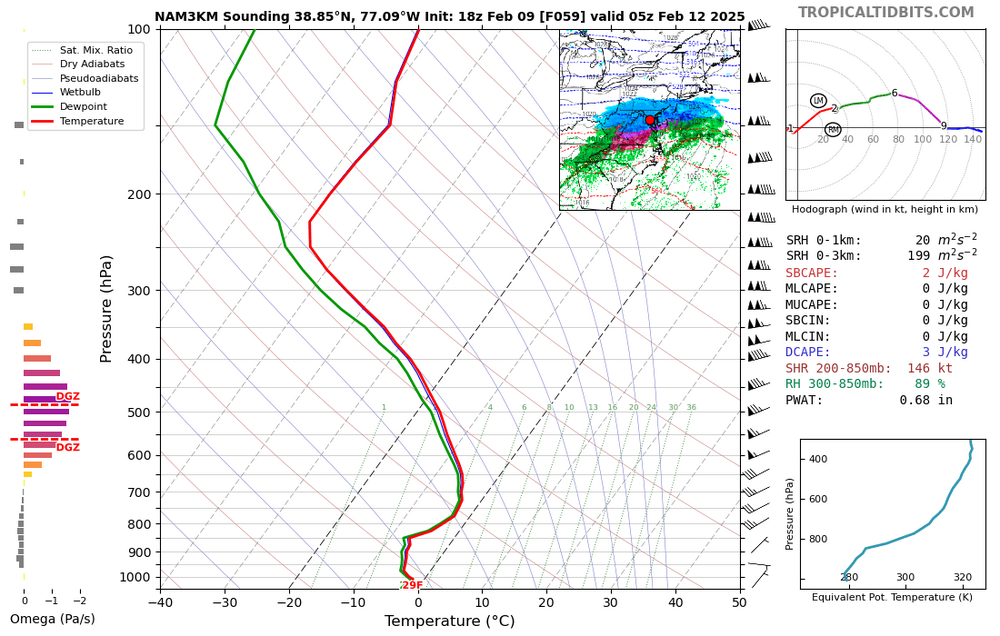
the 12k NAM was definitely overdone, and I don't see much change on the 3k NAM from previous run yet. looks like 5-6" when lopping off the initial inch before dark for DC metro including IAD. This is 10 to 1
-
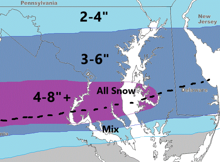
Sticking with my first call, no reason to change it yet. 3-6" DC & NW burbs, 4-8" south till you get to EZF then mixing further south
-
Looks like it removed all the double digit accums, and the rest is usual noise. It's a hold, I think
-
Maybe noise, but looks like precip shield is more robust northward
-
Even if we take out the most bullish outlier, it wouldn't change the forecast for our area.
-
The HRRR and temp issues is why I went conservative! Now there is a chance that even my forecast is too bullish. Hopefully most precip happens after 4 pm and the heaviest comes overnight.
-
First and probably final call unless things change dramatically. Last time I was too bullish, so this time I'm being conservative.
-
Thats what I was thinking. Commanders could also have beaten the Chiefs, though it would have been a much closer game for them.
-
And the north vs south camps are getting closer to each other. Before they were 50-75 miles apart, now only 25-40 miles. We’re in a good spot I think
-
It also appears to me that the timing is mainly an overnight event. If we get the rates, it could pile up pretty easily.
-
3k nam looks good too, 12k maybe a bit overdone but they’re not that far apart.
-
Nam gets northern folks in the game too
-
Halftime show already over? Didn’t realize. Was too busy reading the storm thread
-
I know its only the half, but it feels like the game is over.
-
WOW! Philly is killing it right now.
-
What pass interference? They aren’t playing flag football sheesh
-
As much as I want to say 5-8”, I was too bullish last time so I’m staying conservative this time. Different storm, different scenario though. Better cold air this time except right at the surface, which can be overcome with moderate rates.
-
That’s just smoothing across all ens members. But they’re converging on a max between dc and ezf. Still time to tick north, but probably not by a whole lot
-
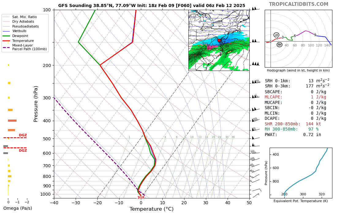
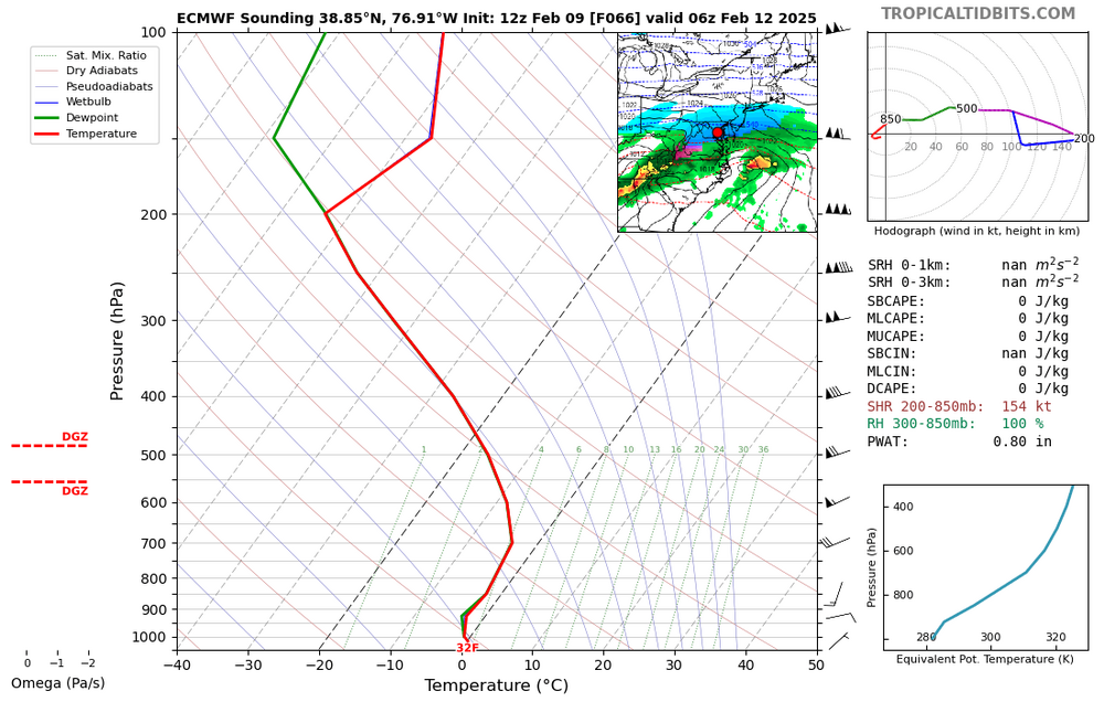
As a counterweight, here are gfs and euro soundings. Hrrr doesn’t go that far out, and rgem weirdly doesn’t have soundings on TT but guessing a degree or two warmer than 3k nam.

-
For posterity. DCA at the middle of the storm
-
Biggest forecasting question for this storm, from a regional POV, is where the heaviest banding sets up and is someone going to see double digit totals out of this.