Terpeast
-
Posts
6,649 -
Joined
-
Last visited
Content Type
Profiles
Blogs
Forums
American Weather
Media Demo
Store
Gallery
Everything posted by Terpeast
-
Feb 22nd/23rd "There's no way..." Obs Thread
Terpeast replied to Maestrobjwa's topic in Mid Atlantic
That little yellow band did wonders for that area. I was barely/briefly on the western edge of it -
Feb 22nd/23rd "There's no way..." Obs Thread
Terpeast replied to Maestrobjwa's topic in Mid Atlantic
BWI 1.9” DCA 1.0” IAD 2.0” -
Feb 22nd/23rd "There's no way..." Obs Thread
Terpeast replied to Maestrobjwa's topic in Mid Atlantic
Glad you’re out of the hospital and feeling better. -
Feb 22nd/23rd "There's no way..." Obs Thread
Terpeast replied to Maestrobjwa's topic in Mid Atlantic
Yeah, the differences between those under best banding and those in between were even more pronounced than usual in this storm due to marginal temps. -
The February 22-23 Late Season Miracle: JV Disco/Banter Thread
Terpeast replied to bncho's topic in Mid Atlantic
A lot of people were asking me about the storm when we got the WSW of 5" or more. "Is it going to snow? Are we really getting 5 inches?" Even though I was more bullish on AMWX (a bit to my detriment haha), I was much more conservative in real life saying "maybe 3 inches if that, and I don't think the roads are gonna be that bad" -
Feb 22nd/23rd "There's no way..." Obs Thread
Terpeast replied to Maestrobjwa's topic in Mid Atlantic
Looks like the models were too far west with the qpf, meaning the SLP capture took a bit longer than originally thought. Those kinds of details are tough to nail down, as are meso banding structures. -
Feb 22nd/23rd "There's no way..." Obs Thread
Terpeast replied to Maestrobjwa's topic in Mid Atlantic
Flurries, maybe get a dusting out of this little random band? -
12/5: 1.5” 12/14: 1.0” 1/1: 0.2” 1/17: 0.3” 1/25: 9.5” (5.5 sn 4.0 ip) 2/6: 0.3” 2/22: 2.5” Total: 15.3”
-
The February 22-23 Late Season Miracle: JV Disco/Banter Thread
Terpeast replied to bncho's topic in Mid Atlantic
I for one am happy to see the benchmark storm track alive and well. And it snowed and everything is white imby. No, we didn’t jack, but we can’t jack them all. We’ll definitely get ours sooner or later, I’m sure of it. And this nor’easter… ain’t she a beaut?! Gotta appreciate the raw power of this storm as a meteorologist.
-
Feb 22nd/23rd "There's no way..." Obs Thread
Terpeast replied to Maestrobjwa's topic in Mid Atlantic
Based on radar trends I think I am done with heavy rates. Light wind-blown snows should continue at least a couple hours before tapering. Not sure how much that’ll add to my 2.5” total, maybe make a run for 3” -
Feb 22nd/23rd "There's no way..." Obs Thread
Terpeast replied to Maestrobjwa's topic in Mid Atlantic
Latest measurement 2.5”, with heavy compaction it’s a little over half that otg -
Feb 22nd/23rd "There's no way..." Obs Thread
Terpeast replied to Maestrobjwa's topic in Mid Atlantic
Mod snow and wind is picking up. Looks like the best rates is just east of me. Things must be insane at dulles town center. At least KIAD should pad its stats!
-
Feb 22nd/23rd "There's no way..." Obs Thread
Terpeast replied to Maestrobjwa's topic in Mid Atlantic
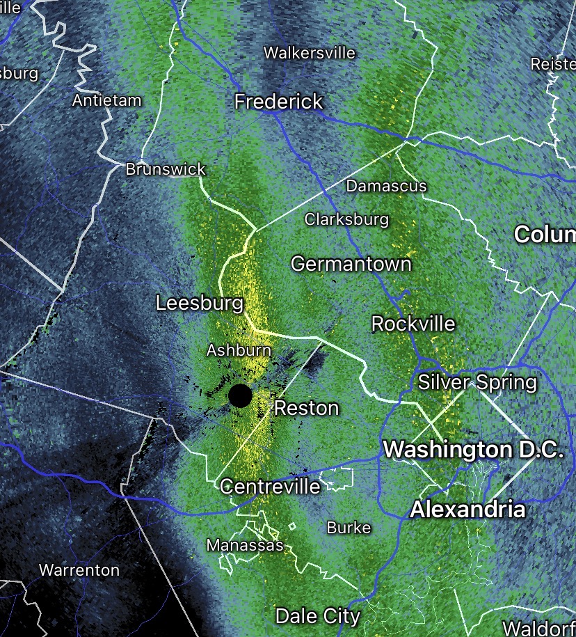
Western norlun band is probably a mile to the east of me. Snowing but not heavily imby -
Feb 22nd/23rd "There's no way..." Obs Thread
Terpeast replied to Maestrobjwa's topic in Mid Atlantic
I asked my wife if its still snowing and she said no (I’m on baby duty rn). Maybe she just didn’t look carefully -
Feb 22nd/23rd "There's no way..." Obs Thread
Terpeast replied to Maestrobjwa's topic in Mid Atlantic
Got a split. This wasn’t modeled, no?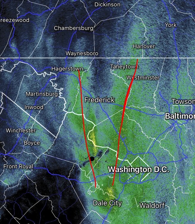
-
Feb 22nd/23rd "There's no way..." Obs Thread
Terpeast replied to Maestrobjwa's topic in Mid Atlantic
Before the flip to snow, I picked up 0.27” and now I have over 2”. Perhaps 5 degrees colder would have put me at 5”. But 2-3 degrees cooler? More blurry. Maybe 3-4” or something like that. -
Feb 22nd/23rd "There's no way..." Obs Thread
Terpeast replied to Maestrobjwa's topic in Mid Atlantic
It might extend north just west of the westiminster-hanover line, but iffy -
Feb 22nd/23rd "There's no way..." Obs Thread
Terpeast replied to Maestrobjwa's topic in Mid Atlantic
I think my wife might have something to say about that… but I appreciate the sentiment haha -
Feb 22nd/23rd "There's no way..." Obs Thread
Terpeast replied to Maestrobjwa's topic in Mid Atlantic
Yeah i think i’m just outside of the western edge, just hoping the back building from HGR keeps me going until midnight -
Feb 22nd/23rd "There's no way..." Obs Thread
Terpeast replied to Maestrobjwa's topic in Mid Atlantic
If you’re between the red lines, you’ll probably get the norlun jacks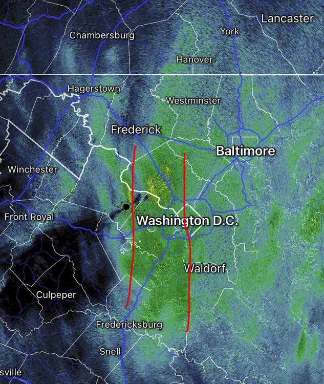
-
Feb 22nd/23rd "There's no way..." Obs Thread
Terpeast replied to Maestrobjwa's topic in Mid Atlantic
That bottom pic, wow! Good shot -
Feb 22nd/23rd "There's no way..." Obs Thread
Terpeast replied to Maestrobjwa's topic in Mid Atlantic
Same, 2”. Great jebwalk this afternoon! -
Feb 22nd/23rd "There's no way..." Obs Thread
Terpeast replied to Maestrobjwa's topic in Mid Atlantic
This might be it?? (Light snow imby atm)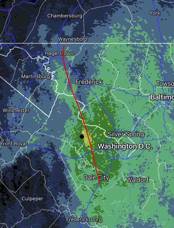
-
Feb 22nd/23rd "There's no way..." Obs Thread
Terpeast replied to Maestrobjwa's topic in Mid Atlantic
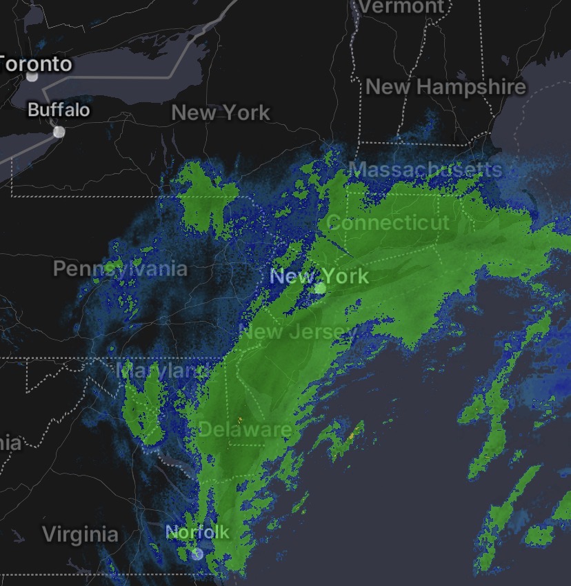
Have an outside chance of verifying at kuchera 3.5" on this map considering I'm already closing on 2" and the norlun hasn't formed/is just starting to form -
Feb 22nd/23rd "There's no way..." Obs Thread
Terpeast replied to Maestrobjwa's topic in Mid Atlantic
1.75" and still snowing moderately