Terpeast
-
Posts
6,591 -
Joined
-
Last visited
Content Type
Profiles
Blogs
Forums
American Weather
Media Demo
Store
Gallery
Everything posted by Terpeast
-
If I'm at 20.6" I'll tolerate a bit of ice. Whatever falls will become a glacier for at least two weeks maybe three.
-
This is 1960s cold.
-
Whatever it takes to get 20"+!
-
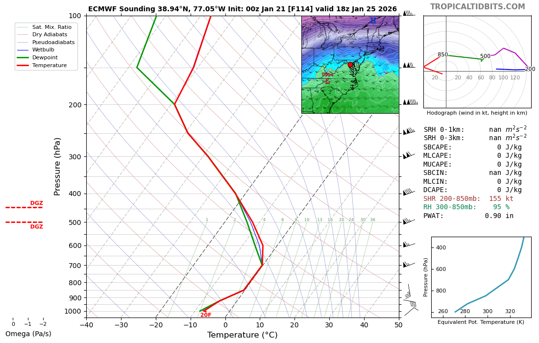
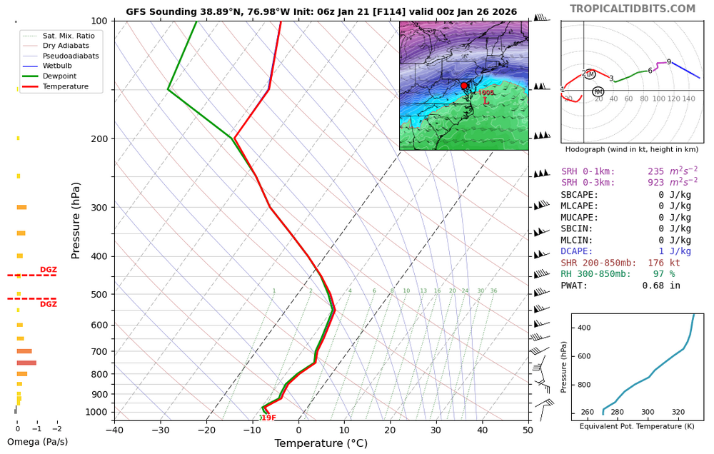
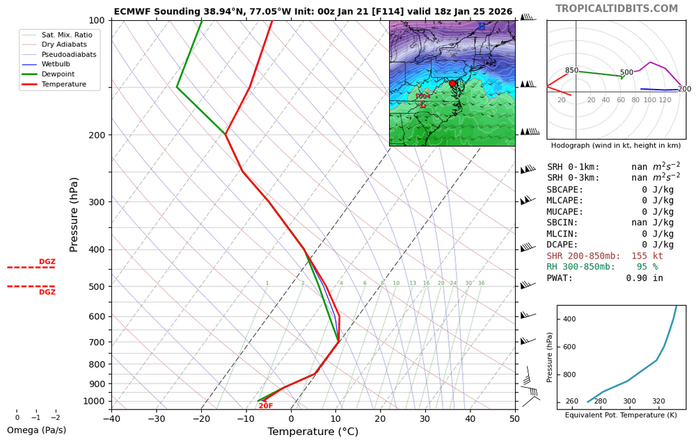
700 mb temps is the level we want to watch for any sleet. BL temps, as depicted right now, are very cold so freezing rain will be minimal. Warmest panel on GFS: Warmest panel on Euro: Warmest panel on CMC - no sounding, but looks like 0-1 degrees C on the sounding over DCA.
-
Now I find myself rooting for the GFS. How things have changed in 24 hours. Perhaps this is the "model reshuffle" I've been talking about for days. Hopefully the recon flights get us new data and things tick back south a bit. We don't want this thing phasing too fast too soon.
-
I see we’ve had a north trend where we flirt with mixing or do mix before the storm ends. I knew it. But still a good front ender.
-
If the cold air/high and TPV strength was overdone by the models AND the NS vort digs even more, that would do it. But I do think 100 miles is the max it can shift from this setup and lead time. Could be less. Hopefully not more.
-
I don’t want too much to change either. But if I had to guess, final track will be shifted about 100 miles north of what the entire model average is now. Maybe 150. Might put our forum in the jack, and maybe even flirt with mixing across the southern half. I’ve seen so many big ones shift north like this.
-
If I understood the brief correctly, 00z 1/22 runs would be the first to ingest that data?
-
This would be the thing that causes that 4 day reshuffle. May it fall in our favor.
-
I was holding my laptop when i refreshed the 18z euro and I almost dropped it!
-
I bet some of those 30” totals in NC is sleet. But a storm like this, especially a phaser, someone somewhere might get 2+ feet.
-
Looks like 12z gfs was a blip rather than a trend.
-
Qpf about the same actually
-
Crept north based on MSLP low position
-
I was coming here to say this. GEFS didn’t really move apart from noise level changes. Op was probably one of the few members that held the sw back too much.
-
We're still up for a model reshuffling probably 12z through 0z tomorrow. GFS is showing that it can still go either way, I just hope it's wrong and it'll cave back again.
-
Don't think its any surprise AI GFS would be similar to GFS since its based off the same initial model conditions
-
I learned from DT way back when that you don't go against the E/E rule.
-
Careful, we don’t want too much too fast. I am 90% sure the storm will come up north anyway. I’m thinking the mix line will reach as far north as EZF/SoMD despite the models saying it’ll stay south of the NC/VA border.
-
Actually GFS AI is very similar to op GFS at both 500mb and sfc low positions. It's the precip shield that's a bit different, but I don't trust AI models on precip. I trust them more on 500mb and storm tracks
-
I would think the mix line moves north from NC to somewhere across south/central VA into lower delmarva, and the snowfall amounts north of that stay the same or a bit less. Just an educated guess
-
I’m up. 200+ new replies. It must be good! Just saw the ens maps - I love where we are sitting right now, and its now <84 hrs where the models are phasing the two streams.
-
I’m gonna end this night on a high note and go to sleep.
-
On 120, precip shield 100 miles north maybe more