psuhoffman
-
Posts
27,419 -
Joined
-
Last visited
Content Type
Profiles
Blogs
Forums
American Weather
Media Demo
Store
Gallery
Everything posted by psuhoffman
-

Feb Long Range Discussion (Day 3 and beyond) - MERGED
psuhoffman replied to WinterWxLuvr's topic in Mid Atlantic
I debated where to put this because it affects the day 7 threat but it’s more about the pattern in general and the other thread will be flooded with 12z analysis so it’s going here. Wanted to illustrate the issue with temps using the 6z gfs because imo it’s a perfect example of DCs problem. this is yesterday... look where the flow is from...straight out of the Arctic. No it’s not a direct cross polar straight from Siberia shot but this is not a pac puke airmass. It’s a polar airmass. It’s just not that cold! 3 days from now...still a flow from the Arctic And look at that pattern!!!! That’s textbook PERFECT west based NAO Rex block, epo ridge bridge. This should dump a truly cold airmass into the northeast. 150 hours... and this is a critical point in the setup...but still not a pac puke issue. Yea pac air comes around the base of the western trough and pumps into the ridge from the south but that’s unavoidable (news flash you can’t completely block the pacific it’s kinda HUGE and upwind) and our source regions to our north are still being fed with air from the Yukon. The pac jet is buckled and there is no straight firehose pac puke blasting in. But...look at the thermals Look at 90 hours, after 5 days of direct flow from the Arctic through the Yukon... THATS IT????? Where’s the beef??? That’s a pathetically weak shallow and non expansive cold pool given the setup and the problem comes after when we need that cold to resist the southerly flow ahead of an approaching wave from the west. Now look at day 6 that cold was too weak to resist that northern steam wave from wrecking the thermals. And yes the flow ahead of the wave is from the south but the dominant flow to our north is still from the Arctic and yet no cold. Just a bubble of near normal air over northern New England. Nothing to resist the surge north of warmth ahead of the next wave. So now we see the effects on the specific surface systems. Wave 1... That’s not an over amped or particularly north wave yes just not cold enough. If there was a true deep cold airmass the snow line would be where the blue line is. We don’t really want a weaker souther wave that would just be bad for everyone. Much weaker and frankly there is no heavy snow anywhere. It just isn’t cold enough. Wave 2 again the track and amplitude are fine. Any weaker and it’s not a significant storm anywhere. It’s just not cold enough...even with the storm to the southeast of us and “cold” pressing its rain to the NW for many. I used the 6z gfs and I haven’t looked at any 12z guidance yet but honestly this post is about the general pattern and fact the thermal profile continues to be warmer then it should be regardless of what the source of the airmass is! That doesn’t mean we won’t get snow from this...but the lack of a truly deep cold airmass is going to make it harder. Less margin for error on every wave. The 6z gfs was a perfect example because both those waves would have been snow in DC simply with a colder airmass. There wasn’t a longwave pattern problem it was a “it’s late January where is the cold” problem. As for the “where is the cold” issue I don’t know what to say. Before someone points out the minor flaws no this isn’t the coldest most direct Siberian express Arctic shot ever. I didn’t say that. But it’s not pac puke. It’s a flow from the Yukon in late January. If that’s no good and we need a direct straight flow from Siberia direct over the North Pole well...ok how often do we ever get that? This setup shouldn’t be too warm to snow. -
Feb Long Range Discussion (Day 3 and beyond) - MERGED
psuhoffman replied to WinterWxLuvr's topic in Mid Atlantic
This is the one issue. Everything is trending towards the favored euro progression but the one problem is the temps are also trending warmer. The 6z eps is a good example. It doesn’t go out far enough to see the end result...but at 144 it’s definitely further south with the low track with less ridging in front. But it’s also still slightly warmer on top and ahead of the wave. What once looked like a colder setup is quickly becoming marginal again. Doesn’t mean it won’t work. It’s a really good pattern. But it means less margin for error. -
Feb Long Range Discussion (Day 3 and beyond) - MERGED
psuhoffman replied to WinterWxLuvr's topic in Mid Atlantic
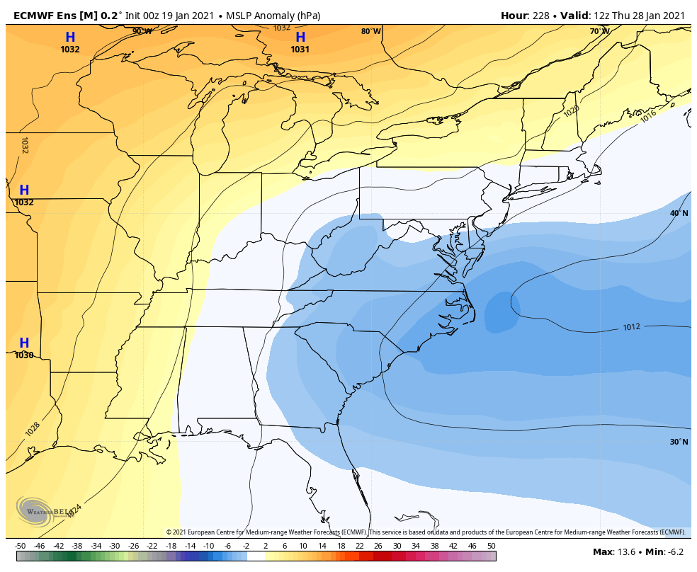
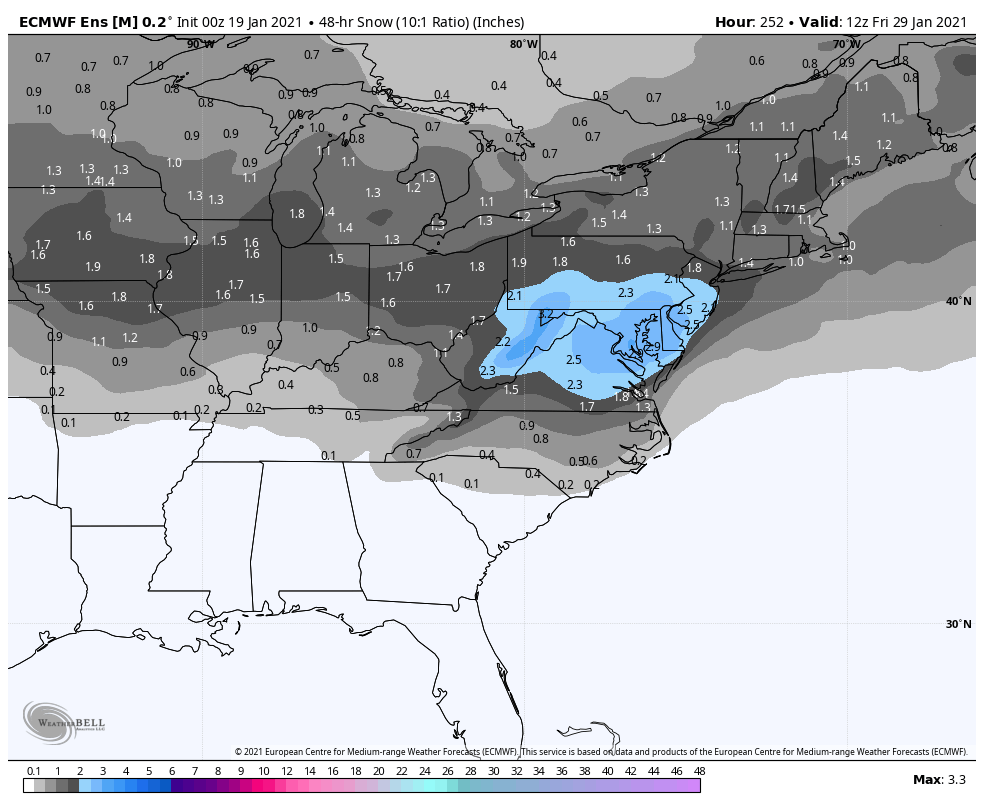
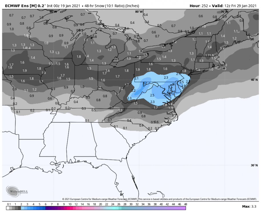
28/29 threat I like that distribution pattern very much. Reminds me of something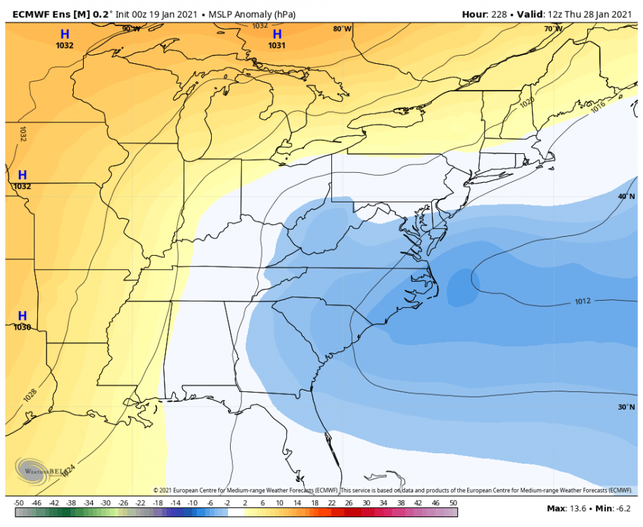

-
Feb Long Range Discussion (Day 3 and beyond) - MERGED
psuhoffman replied to WinterWxLuvr's topic in Mid Atlantic
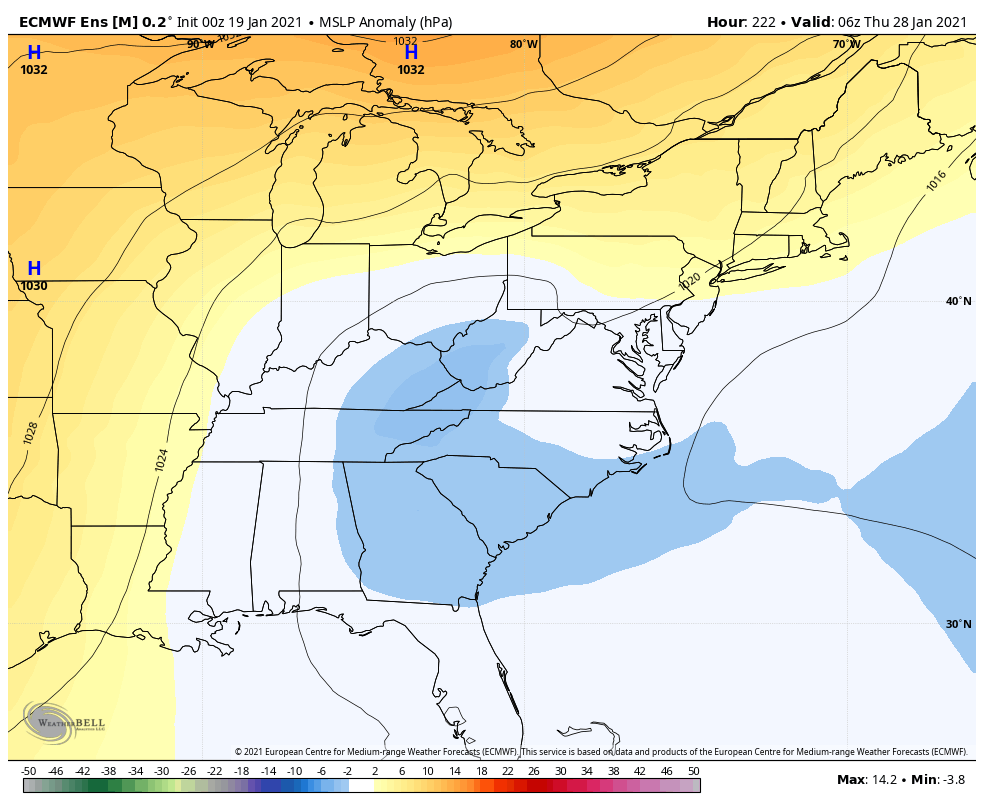
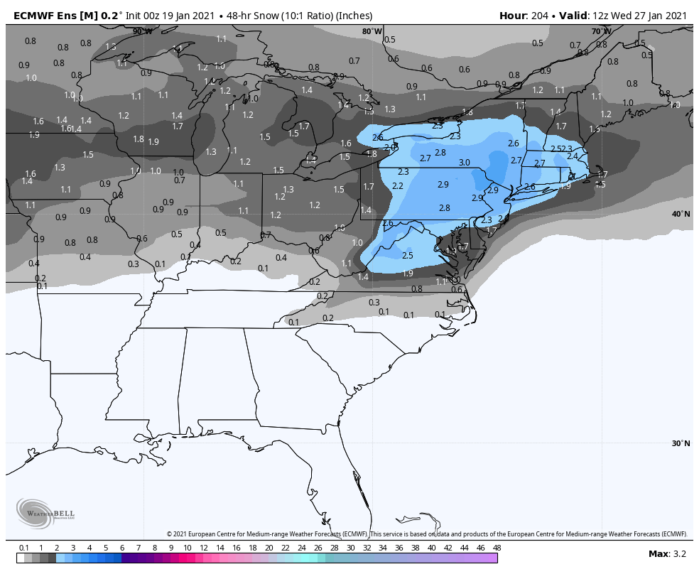
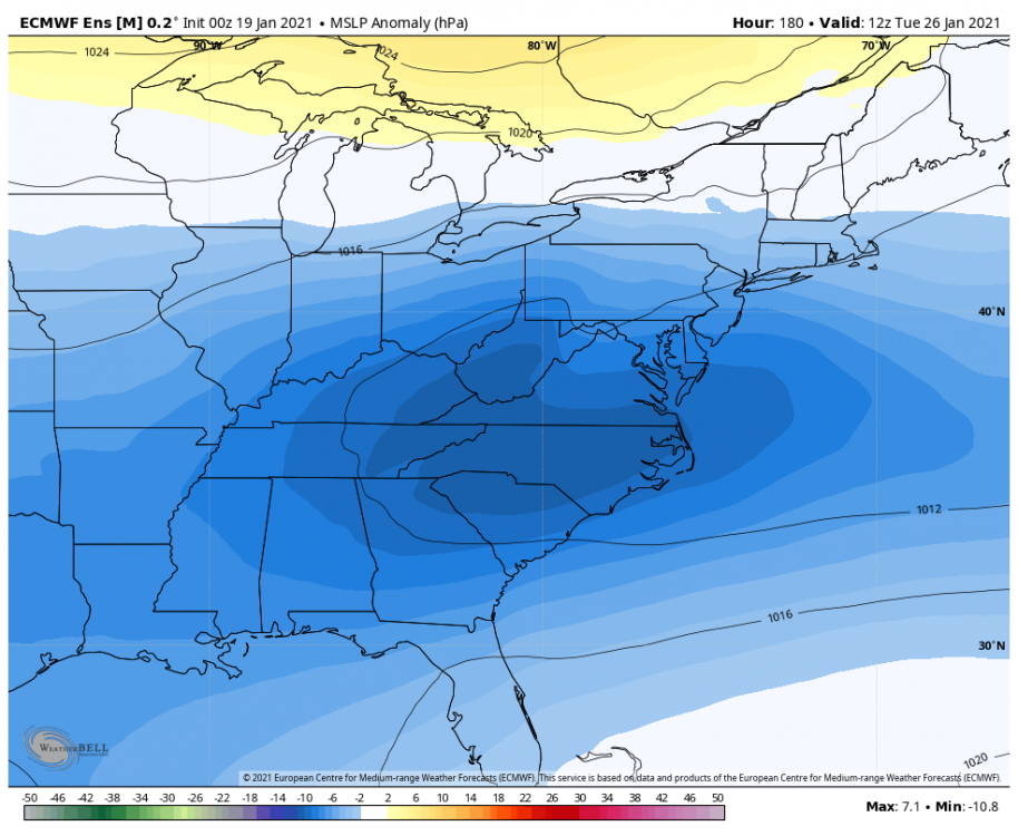
26th threat
-
Feb Long Range Discussion (Day 3 and beyond) - MERGED
psuhoffman replied to WinterWxLuvr's topic in Mid Atlantic
EPS still tracks the wave on the 26th to our south. We’re definitely on the edge flirting with the rain snow line but it’s not as far north as the op. -
Feb Long Range Discussion (Day 3 and beyond) - MERGED
psuhoffman replied to WinterWxLuvr's topic in Mid Atlantic
@Ralph Wiggum @yoda there is a closed h5 low in the Ohio valley tracking east about to cross right over us. Surface low will reorganize along the coast. That was about to crush us in the next 12 hours but the run ended. Figures. -
Feb Long Range Discussion (Day 3 and beyond) - MERGED
psuhoffman replied to WinterWxLuvr's topic in Mid Atlantic
it’s the same wave though the cmc bombs and we’ve been tracking for the 28/29 but the euro is slower with it so it’s a day later then on the cmc. But that’s not the same as kicking the can to the “next” storm. Same storm just slower to progression this run. I am a little disappointed it tracks the system on the 26th north of us but it wasn’t that far north that it might not adjust back. -
Feb Long Range Discussion (Day 3 and beyond) - MERGED
psuhoffman replied to WinterWxLuvr's topic in Mid Atlantic
It’s there just slower. Actually I like what I see at h5. Let’s see where it goes with it. -
Feb Long Range Discussion (Day 3 and beyond) - MERGED
psuhoffman replied to WinterWxLuvr's topic in Mid Atlantic
It over amplifies the wave and rides it just a bit too far north. Big snowstorm for central/northern PA. -
Feb Long Range Discussion (Day 3 and beyond) - MERGED
psuhoffman replied to WinterWxLuvr's topic in Mid Atlantic
Geps improved also but has a shotgun of everything under the sun as well. Hitting the 28/29 hardest. -
Feb Long Range Discussion (Day 3 and beyond) - MERGED
psuhoffman replied to WinterWxLuvr's topic in Mid Atlantic
The gefs is a shotgun of everything. They don’t support the op really but neither do they support any one solution. I count 11 members with a weak lead wave and stronger second wave like the euro. Some miss south. Some nice hits. A couple north. Then some have a stringer lead wave but are colder and snow with that wave. There are some members like the op too. For the 3rd wave that the cmc bombs they have that wave but are all over. Some hits. Some cutters. Largest camp with that is suppressed just south of us. The gefs is obviously not able to handle all the interaction between waves. They are a mess of every possible outcome. ETA: through day 11 a definite improvement though wrt number of hits and mean snowfall over 18z and 12z. -
Feb Long Range Discussion (Day 3 and beyond) - MERGED
psuhoffman replied to WinterWxLuvr's topic in Mid Atlantic
Next week has very good potential. And I still think the best window for something to amplify along the east coast is around the 28/29. But the tight spacing with all these waves makes this complicated and will wreak havoc with the guidance run to run. This isn’t a simple blocking setup with one juiced up stj wave slowly sliding across in a split flow. This involves several waves and how they interact. The first thing to root for us a weaker lead NS wave. The more that amps the more complicated the next wave becomes. If that NS wave gets out of the way the nest case scenario would be the next 2 waves both hit and without much separation between the two it could snow for most of 3 days from that solution. -
Feb Long Range Discussion (Day 3 and beyond) - MERGED
psuhoffman replied to WinterWxLuvr's topic in Mid Atlantic
You mean other then when it kept giving us 2 feet of snow long after every other model shifted north in December ? -
Feb Long Range Discussion (Day 3 and beyond) - MERGED
psuhoffman replied to WinterWxLuvr's topic in Mid Atlantic
I would never trust any one model if it’s on an island. I don’t consider this to be that. The cmc progression has support from the EPS. Maybe the 974 bomb is overdone but the general progression isn’t without support. But if I could only look at the gfs and cmc and had to judge based on that alone honestly CMC right now. It’s been better. Neither is perfect. CMC was way better then the GFS with the Dec storm. It caught the north shift a lot sooner. It also had that crazy trowel deform that gave some places 40” from like 4 days out. That’s impressive. -
Feb Long Range Discussion (Day 3 and beyond) - MERGED
psuhoffman replied to WinterWxLuvr's topic in Mid Atlantic
Ok you want to find excuses to be miserable or just exhale a sigh of relief if we finally get a flush hit and be happy? Btw you’re totally right. But we can’t ignore the really dreadfully awful pacific base state either. And we did (you and I) get a decent snow wrt out respective climo in Dec. If we get a couple more snows by the end of winter maybe that’s as good as we can expect given it’s a Nina in a really awful pac base state. -
Feb Long Range Discussion (Day 3 and beyond) - MERGED
psuhoffman replied to WinterWxLuvr's topic in Mid Atlantic
No model on it’s own is a good bet. But just for reference the CMC has been killing the GFS in verification since its upgrade last year. -
Feb Long Range Discussion (Day 3 and beyond) - MERGED
psuhoffman replied to WinterWxLuvr's topic in Mid Atlantic
The euro has been flirting close to that idea for a while and just missing the final phase by a thread. But it’s been in the ensembles. Some crazy members in there. It’s not the majority but enough evidence for me to stick to my call. -
Feb Long Range Discussion (Day 3 and beyond) - MERGED
psuhoffman replied to WinterWxLuvr's topic in Mid Atlantic
Just let this go the way the pattern says it should one freaking time and let’s call it a winter. This was never supposed to be a good year. Yea it’s frustrating to underperform a -AO winter. But if we can just get one big one...end the drought then relax and whatever else comes after is gravy. -
Feb Long Range Discussion (Day 3 and beyond) - MERGED
psuhoffman replied to WinterWxLuvr's topic in Mid Atlantic
BLUE....BLUE BLUE BLUE -
Feb Long Range Discussion (Day 3 and beyond) - MERGED
psuhoffman replied to WinterWxLuvr's topic in Mid Atlantic
I hate to pull a JB but I’m going too...the progression I went with was made before the ops showed this at the surface and was based on what I felt was the most likely surface result given the longwave pattern. Then some runs started showing exactly that. So long as there is still some support I’m sticking to it. It still makes sense. -
Feb Long Range Discussion (Day 3 and beyond) - MERGED
psuhoffman replied to WinterWxLuvr's topic in Mid Atlantic
Well the cmc definitely didn’t cave to the gfs fully. I don’t like that lead wave but nice progression after. Can only see h5 and slp so far but looks good Imo. And ends with this...obviously likes my idea of an amplifying system on the coast around the 28/29th. -
Feb Long Range Discussion (Day 3 and beyond) - MERGED
psuhoffman replied to WinterWxLuvr's topic in Mid Atlantic
Ok that was scary -
Feb Long Range Discussion (Day 3 and beyond) - MERGED
psuhoffman replied to WinterWxLuvr's topic in Mid Atlantic
The cmc has a healthy trailing wave again with more separation then gfs but that lead NS wave wrecked the thermals in front of it. There is a nice high coming in but dunno if it will get in. That lead NS wave makes this a complicated setup. I don’t like complicated. -
Feb Long Range Discussion (Day 3 and beyond) - MERGED
psuhoffman replied to WinterWxLuvr's topic in Mid Atlantic
That’s still too far out to worry about what an op run says. We’re getting to the range where it’s time to take them more seriously for the first wave though. -
Feb Long Range Discussion (Day 3 and beyond) - MERGED
psuhoffman replied to WinterWxLuvr's topic in Mid Atlantic
Still early but I don’t like some of the signs at 120 on the cmc either. More ridging. Stronger NS lead wave. Not as bad as the gfs but a step towards that look v the euro and previous cmc.