psuhoffman
-
Posts
27,419 -
Joined
-
Last visited
Content Type
Profiles
Blogs
Forums
American Weather
Media Demo
Store
Gallery
Everything posted by psuhoffman
-
Don’t confuse my willingness to acknowledge the very real and concerning longer timescale overall patterns and trends with analysis of a specific threat. I still think, and said so, that it snows in the next 2 weeks. I also think there are signs it’s getting a lot harder to get snow around here. It shouldn’t take this many things lining up. Both those thoughts can be true concurrently.
-

Feb Long Range Discussion (Day 3 and beyond) - MERGED
psuhoffman replied to WinterWxLuvr's topic in Mid Atlantic
Better let someone know -
Feb Long Range Discussion (Day 3 and beyond) - MERGED
psuhoffman replied to WinterWxLuvr's topic in Mid Atlantic
That’s the one that has the best chance actually. And yea @stormtracker I know it’s day 11 but it’s about the progression. As everything retrogrades once the western trough backs off there is a window there with the blocking over Canada for something to amplify in the east. After that Feb depends on whether the AO stays negative. If so I’ll take my chances recycling the same general pattern but with a colder base state going in. Maybe that works out. If the AO flips we torch. -
Feb Long Range Discussion (Day 3 and beyond) - MERGED
psuhoffman replied to WinterWxLuvr's topic in Mid Atlantic
I liked where the euro was going wrt the whole pattern day 10. Details at that range don’t matter. -
Feb Long Range Discussion (Day 3 and beyond) - MERGED
psuhoffman replied to WinterWxLuvr's topic in Mid Atlantic
You didn’t order the wet blanket? -
Feb Long Range Discussion (Day 3 and beyond) - MERGED
psuhoffman replied to WinterWxLuvr's topic in Mid Atlantic
Yea when people say “if the euro showed something twice in a row it used to be a lock” I roll my eyes. Yea it used to only run to 7 days and only ran once a day. So if it showed something twice that means it was at most only 5 days away and the euro held the idea over what would today be 4 consecutive runs. -
Feb Long Range Discussion (Day 3 and beyond) - MERGED
psuhoffman replied to WinterWxLuvr's topic in Mid Atlantic
Euro is night and day wrt how the block interacts with the mid latitude ridge. -
Feb Long Range Discussion (Day 3 and beyond) - MERGED
psuhoffman replied to WinterWxLuvr's topic in Mid Atlantic
Agree wrt Nina. The last few years weren’t a Nina. The pacific problem has been the same regardless of enso. And frankly we’ve barely had any Nina mid latitude pattern response this year. @CAPE but what is the right pattern? If we have a PNA western ridge there will be a trough off the west coast directing mid latitude pac puke into North America. Historically that worked so long as it wasn’t a full on vortex over AK because the puke mainly gets directed up and over into Canada and mixes with the cold continental air and the result is it’s not cold but not a furnace and just cold enough to get snow here But the last few times we tried that the pac jet was too strong and it completely obliterated cold to our north. Ok so that don’t work anymore. But what else does? If we put that ridge off the west coast as an epo ridge because that ridge will be elongated SW to NE (again stronger pac jet and central pac ridge base state effect) it will dump a trough into the southwest. That hasn’t worked because it pumps a ridge into the east (and news flash the Caribbean/gulf/Atlantic are on fire also lol) and the heat it picks up there pumps a huge ridge. We thought with a block it would (should) but if, and I do mean if because it’s not close to done yet, that doesn’t work then what? And relying on the incredibly rare epo NAO ridge bridge block combination isn’t going to save us often. That’s a super rare look. So where do we want the ridge/trough alignment out west exactly? If a pna and an epo doesn’t work? Yea if we somehow got the once in a blue moon rare broad epo and pna ridge...but that’s even more rare then a epo NAO ridge bridge. That’s not a typical wavelength. The epo and pna are typically opposite. If you get a ridge in one you likely get a trough in the other. And frankly it’s made even less likely with a faster pac jet, and that combo was super rare to begin with. Our best bet is as everything retrogrades because there was an epo ridge ahead of it and some cold got in, and as the pattern shifts back to a trough in the northeast pac there will be a window before the cold gets blasted out of North America again with a trough in the east. But that’s a temporary window that took weeks if factors going in an intricate progression. I fail to see this golden pac pattern that leads to a permanent snow friendly regime here if a +epo/+pna/-AO/NAO (what we’ve had for 6 weeks!) doesn’t work anymore. -
Feb Long Range Discussion (Day 3 and beyond) - MERGED
psuhoffman replied to WinterWxLuvr's topic in Mid Atlantic
The “something” is warmth. Even when the flow is suppressive it’s not even that cold. The storm that gets suppressed south of us this week is just rain. But when something amplifies were walking a thin line because warmth has no problem blasting north at any excuse. -
Feb Long Range Discussion (Day 3 and beyond) - MERGED
psuhoffman replied to WinterWxLuvr's topic in Mid Atlantic
That’s a pretty low bar. I still think the period holds the most potential we will see. I covered why at the end of my post to Frd. This threat around the 25 isn’t a done deal yet either. It’s far enough out to see things reverse. But the last 24 hours of trends have been discouraging. Everyone wanted that N pac trough to relax. It did. And so instead of getting mid latitude pac puke we get a heat flux from the tropical pac up through the gulf and pumps a ridge in front of the trough out west. -
Feb Long Range Discussion (Day 3 and beyond) - MERGED
psuhoffman replied to WinterWxLuvr's topic in Mid Atlantic
Unfortunately it’s not totally different it’s simply a continuation of the trend at h5 and what the natural effect of that is. This 24 hours ago was a block look... This is a full latitude ridge... the high latitude ridge does us no good if it links up with the mid latitude ridge. What makes it a “block” is the westerly flow under the ridge. If it links it just becomes a HUGE ridge. -
Feb Long Range Discussion (Day 3 and beyond) - MERGED
psuhoffman replied to WinterWxLuvr's topic in Mid Atlantic
Read the end of my post to Frd -
Feb Long Range Discussion (Day 3 and beyond) - MERGED
psuhoffman replied to WinterWxLuvr's topic in Mid Atlantic
@frd the epo goes negative from day 4-10. That should be sufficient to get cold into the pattern but it gets muted by mid latitude warmth. But what’s the real issue here? Let’s go through the variants. We’ve had an excellent high latitude pattern all winter. We had a pna ridge with eastern trough for most of the last 6 weeks but it didn’t matter because there wasn’t enough COLD in the trough. The trough west of the pna was blasting WARMTH over the top and the trough under it couldn’t create enough mid latitude cold domestically. Now the pna is retrograding into an epo ridge. But that dumps a huge trough into the west (which has been what happens during an epo ridge in the current pacific base state the last several years). Just throwing that out there for everyone crying for epo help! That trough out west pumps a ridge and too much WARMTH gets added by the TNH pattern out of the gulf and we get too much ridge in the central US. After that the ridge retrogrades to a WPO ridge and the trough pulls back into the epo region and we will go back to pac puke WARMTH flooding across eventually. So where do you want the ridge/trough axis in the pacific? There isn’t going to be a ridge across the whole pac with a huge trough across the whole N American continent. But wherever you put the trough in the pacific to the east of it will be a ridge that taps all that WARMTH and blasts it north towards N America. Everyone keeps saying we need the pac to improve but we’ve tried every pac ridge trough axis. So long as the pac is a raging ball of fire with a 200kt screaming jet what configuration do you think works? That all said @stormtracker is going to ban me probably, but I said a few days ago and still think our “best” chance at something is the 3rd wave in the progression (the one around the 30). As everything retrogrades the ridge there has pulled back enough that we could get something to amplify along the east coast. It’s a temporary window before pac puke starts to invade again but there is a really good window of a few days as the pattern retrogrades and essentially reboots back to where we started. That is often how we get a east coast storm. It’s why we usually warm up soon after. -
Feb Long Range Discussion (Day 3 and beyond) - MERGED
psuhoffman replied to WinterWxLuvr's topic in Mid Atlantic
I do think it’s a valid concern though. The blocking is centered a little far SW and has been trending further south recently. That would actually be fine if we didn’t have a deep western trough, but we do and there will be a mid level response to pump a ridge east of it. The trend the last 24 hours across all guidance is for the blocking ridge and the mid latitude ridge to link up and that wrecks the confluence under the block. If they link we essentially end up with a full latitude ridge and the storm will cut. That trend is there across ALL guidance even the EPS. The just has not gone all the way to a full link like the gfs and cmc...yet. But it’s there... On the eps it hasn’t yet become fatal to our chances but it was more pronounced on the op and it’s trending the wrong way. If that trend continues it will be a problem. The good news is we’re still at a range where details will jump around and change. This could reverse today. But the possibility the mid end high latitude ridge links is a serious threat to our snow chances from that wave. -
Feb Long Range Discussion (Day 3 and beyond) - MERGED
psuhoffman replied to WinterWxLuvr's topic in Mid Atlantic
-
Feb Long Range Discussion (Day 3 and beyond) - MERGED
psuhoffman replied to WinterWxLuvr's topic in Mid Atlantic
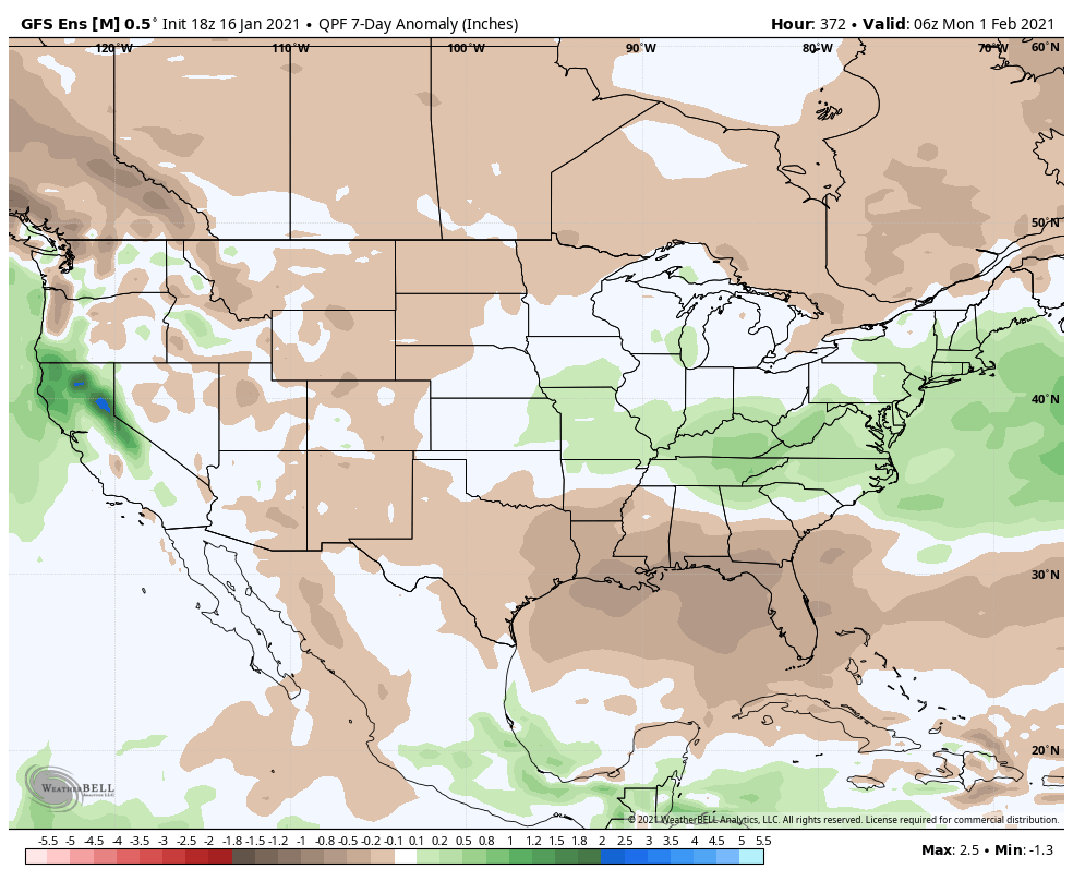
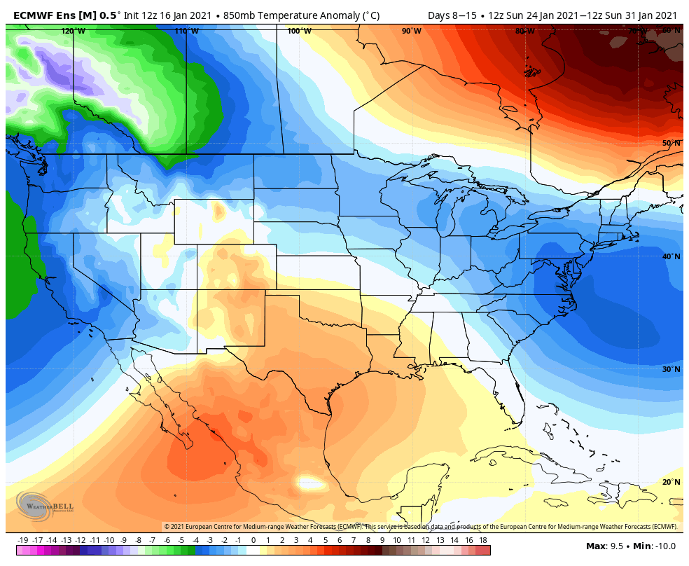
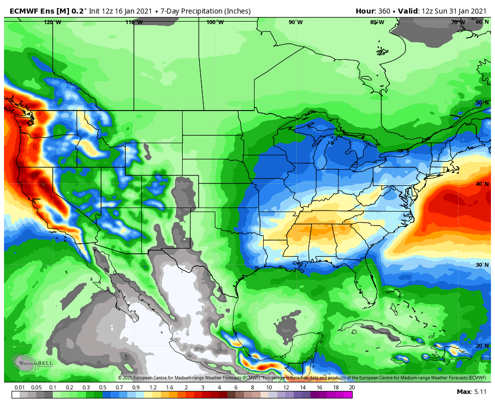
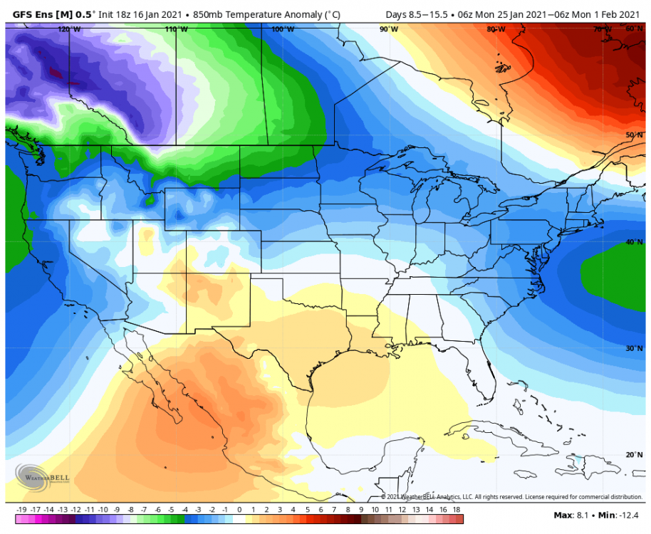
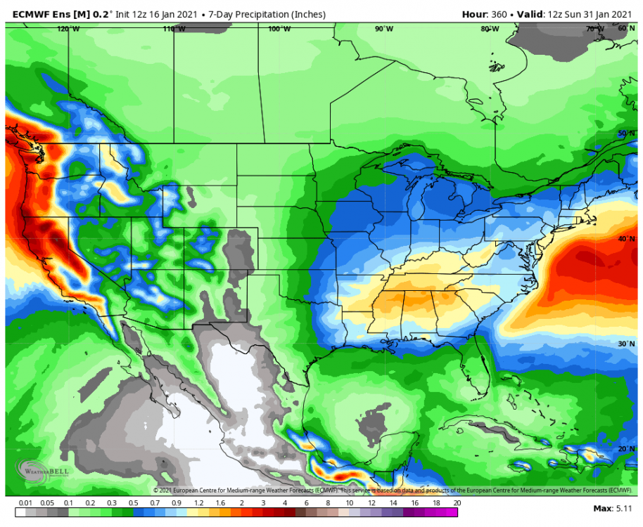
@WxUSAF @CAPE @frd how unlucky can we be with this look lol. 7 day 850 temp anomaly 7 day precip anomaly Same pattern on eps If this doesn’t work I’m out of ideas
-
Feb Long Range Discussion (Day 3 and beyond) - MERGED
psuhoffman replied to WinterWxLuvr's topic in Mid Atlantic
Let’s just simplify this... I’ll take this 7 day precip with these 7 day temps please and thank you.
-
Feb Long Range Discussion (Day 3 and beyond) - MERGED
psuhoffman replied to WinterWxLuvr's topic in Mid Atlantic
Thanks for making me feel REALLY old -
Feb Long Range Discussion (Day 3 and beyond) - MERGED
psuhoffman replied to WinterWxLuvr's topic in Mid Atlantic
It can’t decide what to do with the NS. Yesterday it was diving in front and squashing. 12z it phased and cut. This run it slides across on top. That runs some interference but it’s still a pathetic thermal presentation for late January and no pac puke excuse this time. -
Feb Long Range Discussion (Day 3 and beyond) - MERGED
psuhoffman replied to WinterWxLuvr's topic in Mid Atlantic
Anyone noticed they used the F scale not C. And the color scale has every half degree. So it’s a general 2 degree F difference over a 7 day period a week away. That’s not unusual variance run to run. Their presentation skews the perception imo. -
Feb Long Range Discussion (Day 3 and beyond) - MERGED
psuhoffman replied to WinterWxLuvr's topic in Mid Atlantic
DC averages 5.7” the whole month of January. And all that 5” mean is from a 6 day period. DCs highest avg weekly snowfall is probably about 1.5”. -
Feb Long Range Discussion (Day 3 and beyond) - MERGED
psuhoffman replied to WinterWxLuvr's topic in Mid Atlantic
Exactly but it’s been so long people probably forget how it works. A couple of those 2010 storms had primaries get pretty far NW also... -
Feb Long Range Discussion (Day 3 and beyond) - MERGED
psuhoffman replied to WinterWxLuvr's topic in Mid Atlantic
I must have missed when we asked for a wet blanket today. -
Feb Long Range Discussion (Day 3 and beyond) - MERGED
psuhoffman replied to WinterWxLuvr's topic in Mid Atlantic
1. The low moves up west of the apps then transfers to eastern NC 2. there is a banana high over the top 3. read my post about the dry air -
Feb Long Range Discussion (Day 3 and beyond) - MERGED
psuhoffman replied to WinterWxLuvr's topic in Mid Atlantic
It’s way too soon to be worried about this...but wanted to point something out that can be useful when we are closer to an event. There are lots of variables but one factor that helped us survive a primary track to our west was this. As the system approaches this looks precarious at a glance. The mid level boundary isn’t that far to our SW. But look at the 850 temps to our south and southwest. 1-2 c mostly. Now look at the humidity. that whole area is bone dry. All that air will advect north ahead of the low. As it saturates and lifts north it will be plenty cold enough. The actual boundary of air that wouldn’t support snow that would have to advect north is much further south.